Any feedback welcome. Planning a through walk from Lake Ada, to Mersey forest road late spring. Options are a) via Lake Fanny then nw b) SW from fanny to Lake Sally, then nw to lake ball and DK hut. Questions are
A) any tales fro hell vehicles parked o/n at Ada (possibly 3 nights)
B) relative merits either of these options- campsites/difficulty/navigation issues-(terrain effects on compass etc) /scenic qualities.
Proposal is to allow 2 full days for the through walk plus allow another 2 for general stuff in the walls area. At this point, I am considering doing it solo, so again, any feedback here is welcome. Whilst new to Tas. I am a fairly capable bw but also aware of the vagaries /challenges of climate in the Walls area, along with my approaching dotage (mid 60's) also aware of the increased risks involved in walking in remote areas. It is likely I will be carrying a PLB
Many thanks
WOJ from east
Forum rules
Tasmania specific bushwalking discussion. Please avoid publishing details of access to sensitive areas with no tracks.
Tasmania specific bushwalking discussion. Please avoid publishing details of access to sensitive areas with no tracks.
14 posts
• Page 1 of 1
WOJ from east
![]() by bluetongue » Mon 15 Jul, 2013 8:36 am
by bluetongue » Mon 15 Jul, 2013 8:36 am
- bluetongue
- Nothofagus gunnii

- Posts: 35
- Joined: Mon 25 Jul, 2011 8:06 pm
- Region: Tasmania
- Gender: Male
Re: WOJ from east
![]() by gayet » Mon 15 Jul, 2013 3:18 pm
by gayet » Mon 15 Jul, 2013 3:18 pm
I haven't done it yet but I have long considered walking into the Walls from Lake Ada, to Lk Antimony then round to Ball via Silver, Sally et al. I like the idea of this because it doesn't require hauling myself up onto the Plateau first.
I had planned to drive to Ada then walk to Antimony on day 1, Day 2 to Lake Ball and potter around there for a while, after that it depended on how much time I actually had as to where else I went. Return toi the car the same way but in one day rather than spread over 2.
From what I have gathered, Ada to Fanny or Antimony will be a bit bleak as it is very exposed and not much in the way of trees. The compensation is comparatively flat. No difficulties to navigation as far as I am aware, there are tracks through there and its easy enough (in the right weather) to be able to see your general destination.
There are camp sites around the lakes, as well as some small fishing huts (at Antimony and a hut at Ball). Sites at Dixons as well.
Doing it solo - shouldn't be a problem if you take the appropriate precautions and gear. My interest is less in climbing peaks and more in photographing interesting bits at ground level or eye level. Macro lens is the most important.
Enjoy it whenever you go.
- gayet
- Phyllocladus aspleniifolius

- Posts: 960
- Joined: Sat 12 Feb, 2011 8:01 pm
- Location: Wallan
- Region: Victoria
- Gender: Female
Re: WOJ from east
![]() by Ent » Mon 15 Jul, 2013 3:30 pm
by Ent » Mon 15 Jul, 2013 3:30 pm
Hi
The trip is pretty standard fare for largely off track walking, but unless you have a proper four wheel drive you might not make it as far to the start of the walk that you would think looking at the road maps.
Spring can mean any weather so take stuff that you would for winter. Navigation can be a challenge especially if the peaks are clouded out as all lakes can start to look the same. Also if it snows easy to follow tracks can get lost.
I know plenty of people would do the area solo but I am not one. Really it is a place for a small group to enjoy rambling around in. If you get lost or injured life would not be much fun as it would be considerable time before someone found you. Once you hit the Walls then you are on a super highway of bushwalking.
A GPS and ability to use it would be helpful as well. This area is notorious for people getting lost.
Cheers
"lt only took six years. From now on, l´ll write two letters a week instead of one."
(Shawshank Redemption)
(Shawshank Redemption)
-
Ent - Lagarostrobos franklinii

- Posts: 4086
- Joined: Tue 13 May, 2008 3:38 pm
- Region: Tasmania
Re: WOJ from east
![]() by mArt » Mon 15 Jul, 2013 4:00 pm
by mArt » Mon 15 Jul, 2013 4:00 pm
Tough along the top from Fanny to Dixons - its very rocky and would be difficult to navigate if the viz
was poor. I walked both routes in recent years.
As Ent says road might be closed (at eastern of Augusta), and I agree with him that the entire area is
challenging to navigate even in good visibility as the land-marks are generally distant and subtle in their
similarity.
was poor. I walked both routes in recent years.
As Ent says road might be closed (at eastern of Augusta), and I agree with him that the entire area is
challenging to navigate even in good visibility as the land-marks are generally distant and subtle in their
similarity.
- mArt
- Nothofagus gunnii
- Posts: 14
- Joined: Tue 12 Apr, 2011 12:48 pm
- Region: Tasmania
- Gender: Male
Re: WOJ from east
![]() by tigercat » Mon 15 Jul, 2013 4:05 pm
by tigercat » Mon 15 Jul, 2013 4:05 pm
As a solo bush walker I regard a PLB or sat phone as mandatory equipment.
Enjoy your walk
tc
Enjoy your walk
tc
Wilderness: restful and healing for the mind and spirit
-
tigercat - Athrotaxis selaginoides

- Posts: 1338
- Joined: Thu 29 Mar, 2012 8:21 pm
- Region: Tasmania
Re: WOJ from east
![]() by norts » Mon 15 Jul, 2013 4:35 pm
by norts » Mon 15 Jul, 2013 4:35 pm
Check that the gate at Lake Augusta is open or you are in for long walk on a boring road. We did Ada to Jerusalem via Antimony and Bernes Valley and then returned via Zion Gate and Lake Fanny. Saves a car shuffle. Also there is only a small distance of back tracking, unless the gate isn't open of course. That road was one of the most boring walks I have done, luckily we found a soccer ball at the Lake Ada Car park. So on the way back we were kept amused.
Roger
Roger
- Ada to Augusta Rd.jpg (71.02 KiB) Viewed 9385 times
-
norts - Lagarostrobos franklinii
- Posts: 2013
- Joined: Wed 01 Aug, 2007 10:45 am
- Location: Germantown Tas.
- Region: Tasmania
Re: WOJ from east
![]() by Graham51 » Mon 15 Jul, 2013 7:01 pm
by Graham51 » Mon 15 Jul, 2013 7:01 pm
I have walked Ada to Walls probably 6 or more times. I have normally followed the old road to Lake Fanny then followed a creek on the western side of Fanny up to the long tarn (NOT Long Tarns) that takes you almost all the way to Dixons Kingdom. Only scrub is a little following that creek up.
At the start of last year my wife and I followed the Pine River back but the track is nowhere near as clear as it was 10 or 15 years ago. On that trip we walked in to the lakes before Fanny (is it Powanna?) then headed a bit further north and on to Long Tarn and. Turrana Bluff. We headed directly to the Walls from about the middle of Long Tarn via Scoparia Ridge which wasn't as formidable as its name suggests.
In claggy conditions a GPS on the plateau would be invaluable if you punched in some waypoints before you set out. That's what I did when I walked from Lake McKenzie to Mt Of Jupiter and down to Lake StClair. Didn't use it much but a couple of times it was handy.
Good luck with your walk. It's beautiful up there.
-
Graham51 - Lagarostrobos franklinii
- Posts: 3306
- Joined: Mon 11 Oct, 2010 7:19 pm
- Region: Tasmania
- Gender: Male
Re: WOJ from east
![]() by Peaksnik » Mon 15 Jul, 2013 9:22 pm
by Peaksnik » Mon 15 Jul, 2013 9:22 pm
In a party of three, I did the walk from Lake Ada carpark to the Walls via Antinomy and Bernes Valley. If solo take a PLB since if you are injured help is unlikely to come via a passerby. There's a track to Antinomy hut that can be reached in a day (only a couple of spots where you might end up following lead that peters out; then just bactrack). The hut might be useful if the weather was extreme but otherwise it doesn't have much going for it. We chose to camp by Lake Silver then walked up to Dixons K. the next day. Plenty of route options up the valley. We tried to avoid stands of pine but some sections go down to lake edges making it slow going in parts. Otherwise it is very pleasant walking amidst untamed, open terrain.
I haven't done the walk to Lake Fanny and up the Powena Creek, although I have entered Zion Gate from the top of Powena after crossing from the NE. That experience of the northern end of Powena would not fill me with expectations of a pleasant time at its southern end - but I'm happy to have my trepidations put to rest by anyone with first hand experience. Enjoy.
I haven't done the walk to Lake Fanny and up the Powena Creek, although I have entered Zion Gate from the top of Powena after crossing from the NE. That experience of the northern end of Powena would not fill me with expectations of a pleasant time at its southern end - but I'm happy to have my trepidations put to rest by anyone with first hand experience. Enjoy.
- Peaksnik
- Athrotaxis cupressoides

- Posts: 112
- Joined: Wed 12 Mar, 2008 12:02 pm
- Location: Brisbane
- Gender: Male
Re: WOJ from east
![]() by Graham51 » Mon 15 Jul, 2013 9:42 pm
by Graham51 » Mon 15 Jul, 2013 9:42 pm
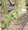
The top end of Poweena is open going as in this picture. I found it easy to navigate with just map and maybe a little compass.
- Attachments
-
- Signs of former use in the upper Poweena area
- P2040014 (Custom).JPG (110.64 KiB) Viewed 9330 times
-
Graham51 - Lagarostrobos franklinii
- Posts: 3306
- Joined: Mon 11 Oct, 2010 7:19 pm
- Region: Tasmania
- Gender: Male
Re: WOJ from east
![]() by PeterJ » Mon 15 Jul, 2013 10:33 pm
by PeterJ » Mon 15 Jul, 2013 10:33 pm
I agree with Graham51, who has done heaps of bushwalking.
I have walked from Lake Ada quite a number of times over the years and never had any problems with leaving the car there. Usually there are a few fishing folk abouty too. The first hour from Ada is a bit open and less interesting, but from then on it is beautiful walking country.
Care needs to be taken in picking the track down to Lake Antimony.
A GPS with preloaded waypoints is a good option and adds a level of certainty with navigation.
You can have a look a look at my photos from the last walk in the region from November 2012. https://picasaweb.google.com/1126595273 ... WallsNov12
If you would like a GPX file of waypoints and track or any detailed information send me a private message
Peter
My bushwalks pages
My bushwalks pages
-

PeterJ - Athrotaxis cupressoides
- Posts: 449
- Joined: Mon 24 Sep, 2007 5:06 pm
- Location: Lenah Valley
- Region: Tasmania
- Gender: Male
Re: WOJ from east
![]() by Peaksnik » Tue 16 Jul, 2013 3:50 pm
by Peaksnik » Tue 16 Jul, 2013 3:50 pm
The upper Powena area as shown in Graham51's photo is very unlike that which falls immediately from Zion Gate. The photo is an encouragement to explore this area further.
- Peaksnik
- Athrotaxis cupressoides
- Posts: 112
- Joined: Wed 12 Mar, 2008 12:02 pm
- Location: Brisbane
- Gender: Male
Re: WOJ from east
![]() by WildeOne » Sat 31 Dec, 2016 2:25 pm
by WildeOne » Sat 31 Dec, 2016 2:25 pm
Hello PeterJ, I'm a new member so i'm unable to private message.
We're travelling down from QLD to explore the WOJ. The original plan was to enter via Mersey Forest Rd but now we're entering via Lake Augusta.
Not being seasoned walkers we were hoping to rely on a track and it appears from Lake Fanny it's self navigation.
We have a GPS. I read above you have a GPX file of waypoints and track details, if you were able to share it would be much appreciated.
We were planning to hike in, camp at Dixon's, spend the next day exploring the walls, another night at Dixon's (or open to suggestions) then hike out.
Thanks John
- WildeOne
- Nothofagus cunninghamii

- Posts: 1
- Joined: Sat 31 Dec, 2016 2:10 pm
- Region: Queensland
- Gender: Male
Re: WOJ from east
![]() by taswegian » Sat 31 Dec, 2016 4:03 pm
by taswegian » Sat 31 Dec, 2016 4:03 pm
John I'd encourage you to also get a good map of that area.
That and a compass would serve you well.
GPS tracks are good, but if you can read a map, in clear (not misty) days that country can be traversed easily.
A map gives you idea of features that peering into a GPS don't.
I'm not for one minute knocking GPS. If battery fails you have a backup too.
Caveat is, you need some basic map skills.
You could go to LIST, and Walls of Jerusalem in their Map section and print your own from that.
Turn on Topographic as background. Need to zoom in to see appropriate level of detail.
Enjoy your trip. It's a fabulous place.
Be also prepared for any weather, even snow!
If you want to see temperatures, look on BOM (meteorological) site and search Liawenee.
-
taswegian - Phyllocladus aspleniifolius
- Posts: 888
- Joined: Tue 27 Jul, 2010 8:34 pm
- Region: Tasmania
- Gender: Male
Re: WOJ from east
![]() by PeterJ » Mon 02 Jan, 2017 8:12 am
by PeterJ » Mon 02 Jan, 2017 8:12 am
WildeOne wrote:Hello PeterJ, I'm a new member so i'm unable to private message.
Go to the "Control Panel" just below the "Board Index" below the banner heading and that will get you to your messages.
I have sent one to you.
Peter
My bushwalks pages
My bushwalks pages
-
PeterJ - Athrotaxis cupressoides
- Posts: 449
- Joined: Mon 24 Sep, 2007 5:06 pm
- Location: Lenah Valley
- Region: Tasmania
- Gender: Male
14 posts
• Page 1 of 1
Who is online
Users browsing this forum: No registered users and 40 guests