waterfall bagging
Forum rules
Tasmania specific bushwalking discussion. Please avoid publishing details of access to sensitive areas with no tracks.
Tasmania specific bushwalking discussion. Please avoid publishing details of access to sensitive areas with no tracks.
50 posts
• Page 1 of 2 • 1, 2
waterfall bagging
![]() by biggc » Sat 18 Apr, 2009 8:48 am
by biggc » Sat 18 Apr, 2009 8:48 am
hello all im currently bagging as many waterfalls as i can but are not sure how to find many of the lesser known falls overnight walks are not an option for me at the moment but any info would be great 
- biggc
- Nothofagus gunnii

- Posts: 46
- Joined: Sat 18 Apr, 2009 8:30 am
- Region: Tasmania
Re: waterfall bagging
![]() by sthughes » Sat 18 Apr, 2009 9:19 am
by sthughes » Sat 18 Apr, 2009 9:19 am
In the BWT Wiki there is a list of them! http://bushwalk.com/wiki/index.php?title=List_of_Tasmanian_Waterfalls
However most of them I don't know how to get to. But if you do a Google search (or a search of BWT) using the Waterfall name some more info might turn up.
However most of them I don't know how to get to. But if you do a Google search (or a search of BWT) using the Waterfall name some more info might turn up.
"Don't do today what you can put off 'till tomorrow." (Work that is!)
-
sthughes - Lagarostrobos franklinii

- Posts: 2427
- Joined: Wed 05 Mar, 2008 12:53 pm
- Location: Ulverstone
- Region: Tasmania
- Gender: Male
Re: waterfall bagging
![]() by biggc » Sat 18 Apr, 2009 1:26 pm
by biggc » Sat 18 Apr, 2009 1:26 pm
thanks mate already have the list just hoping people knew about some of them
- biggc
- Nothofagus gunnii
- Posts: 46
- Joined: Sat 18 Apr, 2009 8:30 am
- Region: Tasmania
Re: waterfall bagging
![]() by NETAssie » Sat 18 Apr, 2009 7:57 pm
by NETAssie » Sat 18 Apr, 2009 7:57 pm
There are some great waterfalls in the North East. You can see some brief details on the following link:
http://www.tindragontrailcottages.com.au/Waterfalls.htm
I hope this helps.
http://www.tindragontrailcottages.com.au/Waterfalls.htm
I hope this helps.
- NETAssie
- Nothofagus cunninghamii

- Posts: 1
- Joined: Sat 18 Apr, 2009 7:48 pm
- Region: Tasmania
Re: waterfall bagging
![]() by MrCAMEL » Sat 18 Apr, 2009 8:11 pm
by MrCAMEL » Sat 18 Apr, 2009 8:11 pm
biggc wrote:thanks mate already have the list just hoping people knew about some of them
Well,
Of the 230+ listed there, which ones do you what to know about?
Vrilen Snyson Racing: Finding us all a Vrilen
Asparagus: Experience the versatility
Asparagus: Experience the versatility
-

MrCAMEL - Athrotaxis cupressoides

- Posts: 104
- Joined: Fri 18 Jul, 2008 11:10 pm
- Location: Mongol Land
- Region: Other Country
Re: waterfall bagging
![]() by biggc » Sun 19 Apr, 2009 9:17 am
by biggc » Sun 19 Apr, 2009 9:17 am
barrow falls, leda falls, is preston falls actually called delaneys falls is cleft rock falls split rock falls has anyone been to betts falls near sisters beach is there 3 falls at lilydale cause i only found 2. On the map i have where the castra falls are there are 8 bars across the river i know three are called castra, silver and dynamo what are the names of the other 5 or perhaps to make it easier i should just list the falls i have bagged
- biggc
- Nothofagus gunnii
- Posts: 46
- Joined: Sat 18 Apr, 2009 8:30 am
- Region: Tasmania
Re: waterfall bagging
![]() by MrCAMEL » Sun 19 Apr, 2009 11:09 am
by MrCAMEL » Sun 19 Apr, 2009 11:09 am
biggc wrote:barrow falls, leda falls, is preston falls actually called delaneys falls is cleft rock falls split rock falls has anyone been to betts falls near sisters beach is there 3 falls at lilydale cause i only found 2. On the map i have where the castra falls are there are 8 bars across the river i know three are called castra, silver and dynamo what are the names of the other 5 or perhaps to make it easier i should just list the falls i have bagged
That was really hard to read
Maybe you might know a bit about the Falling water in this thread.
http://bushwalkaustralia.com/forum/view ... 83&p=12775
Here is a story about Preston Falls.
http://www.world-of-waterfalls.com/aust ... falls.html
Also, you should check out the Waterfall thread
http://bushwalkaustralia.com/forum/view ... p?f=9&t=41
It's pretty.
Vrilen Snyson Racing: Finding us all a Vrilen
Asparagus: Experience the versatility
Asparagus: Experience the versatility
-
MrCAMEL - Athrotaxis cupressoides
- Posts: 104
- Joined: Fri 18 Jul, 2008 11:10 pm
- Location: Mongol Land
- Region: Other Country
Re: waterfall bagging
![]() by biggc » Sun 19 Apr, 2009 2:21 pm
by biggc » Sun 19 Apr, 2009 2:21 pm
thanks for that should keep me busy for a day or so 
- biggc
- Nothofagus gunnii
- Posts: 46
- Joined: Sat 18 Apr, 2009 8:30 am
- Region: Tasmania
Re: waterfall bagging
![]() by walkinTas » Fri 12 Jun, 2009 2:22 am
by walkinTas » Fri 12 Jun, 2009 2:22 am
I'll skip the first two because you seem to be getting somewhere with separate posts (Barron Falls and Leda Falls).
Actually, the whole Meander Valley Falls question needs a bit more work. Split-rock/cleft rock Falls, Bastion Cascades, Chasm Falls, Smoko Falls, Smoko Creek (unnamed) Falls, Mother Cummings Rivulet Falls all need an accurate Lat/Long reading for confirmation. As you can see from the Smoko Falls link, some of the work has been done.
Not sure if all this helps, but I hope some of it is useful. Anyway, good luck with your falls bagging and please let me know if you visit any falls and get an accurate set of co-ordinates. A little report on each trip would also help.
I've made a few mods to the Wiki List including changes to the co-ordinates after a recent walk to Cuckoo Falls. One day I would like to divide the List of Waterfalls into three lists: Short Walks, Day Walks and Camping Trips. One day
There are two sets of falls shown on tasmaps: Falls (-41.2889645, 146.0636210) and Delaneys Falls (-41.2863875, 146.0645916). TheList clearly identifies Preston Falls as per the first reference. Both theList and the tasmap clearly identify the other set as Delaneys Falls. So according to theList, Preston falls and Delaneys Falls are two separate falls - hence the Wiki List shows both. But others would say that the falls are called Upper Preston Falls and Preston or Delaney Falls.biggc wrote:is preston falls actually called delaneys falls
- excellent question. I concluded they were the same, but I'm not confident. That is why they are in the bottom list on the Wiki along with all the other unresolved issues. TheList shows Cleft Rock Falls but no grid reference. There is no Split Rock Falls on theList. The track on the map is called Split Rock Track, but there is no fall marked. I'd be pleased for any additional info that anyone can supply.biggc wrote:is cleft rock falls split rock falls
Actually, the whole Meander Valley Falls question needs a bit more work. Split-rock/cleft rock Falls, Bastion Cascades, Chasm Falls, Smoko Falls, Smoko Creek (unnamed) Falls, Mother Cummings Rivulet Falls all need an accurate Lat/Long reading for confirmation. As you can see from the Smoko Falls link, some of the work has been done.
- can't help with that.biggc wrote:has anyone been to betts falls near sisters beach
I also only found two. I amended the Wiki list. Foolishly, I didn't have the GPS in my pocket on that walk so I didn't get co-ordinates.biggc wrote:is there 3 falls at lilydale cause i only found 2.
Violet, Coxs, Step, Dynamo, and Silver Falls are clearly shown on the map. Castra Falls on the List of Waterfalls is shown as per the co-ordinates on theList. This map (below) shows one unnamed set of falls. That makes seven, so can you tell me where the other one is?biggc wrote:On the map i have where the castra falls are there are 8 bars across the river i know three are called castra, silver and dynamo what are the names of the other 5
- Castra-Falls.png (694.82 KiB) Viewed 23898 times
Not sure if all this helps, but I hope some of it is useful. Anyway, good luck with your falls bagging and please let me know if you visit any falls and get an accurate set of co-ordinates. A little report on each trip would also help.
I've made a few mods to the Wiki List including changes to the co-ordinates after a recent walk to Cuckoo Falls. One day I would like to divide the List of Waterfalls into three lists: Short Walks, Day Walks and Camping Trips. One day
- walkinTas
- Lagarostrobos franklinii
- Posts: 2934
- Joined: Thu 07 Jun, 2007 1:51 pm
- Region: Tasmania
Re: waterfall bagging
![]() by johnw » Fri 12 Jun, 2009 1:49 pm
by johnw » Fri 12 Jun, 2009 1:49 pm
walkinTAS wrote:There is no Split Rock Falls on theList. The track on the map is called Split Rock Track, but there is no fall marked. I'd be pleased for any additional info that anyone can supply.
wT this might not be much help, but I've been to what I think is Split Rock Falls. However it was only a dribble if I recall correctly and I'm still not certain we actually reached the falls. Some of the tracks around there are a bit vague. I was following some notes/map from the Chapman day walks book (probably the ones listed for Meander Falls, but we didn't do that walk). I remember going up through Split Rock itself and then following a vague wet track through the forest for a while to a small amphitheatre containing the "falls". We were a bit short on time and it was getting dark in the forest so didn't explore further. It's possible I may have a photo at home, I'll have a look for it later. Someone may come up with better info in the meantime.
John W
In Nature's keeping they are safe, but through the agency of man destruction is making rapid progress - John Muir c1912
In Nature's keeping they are safe, but through the agency of man destruction is making rapid progress - John Muir c1912
-

johnw - Lagarostrobos franklinii
- Posts: 9026
- Joined: Wed 23 Jan, 2008 11:59 am
- Location: Macarthur Region - SW Sydney
- Region: New South Wales
- Gender: Male
Re: waterfall bagging
![]() by biggc » Sat 13 Jun, 2009 1:19 pm
by biggc » Sat 13 Jun, 2009 1:19 pm
thanks walkintas it did help ill have to get back to you on the other fall its off this huge map thats hanging on the wall at my work, i recently purchased one myself from a place in hobart asking for the exact same one but alas it is different. cost me 150 dollars and is about six feet tall. Ive got access to all tasmanias section maps so im transfering the falls from them onto the big map with pins, red pins are the ones i havent done and the blue ones are completed, needless to say the map is quite red.. A section map called sophia has 74 waterfalls on them and most are unnamed. I will also have to invest in a gps any reccomendations?
- biggc
- Nothofagus gunnii
- Posts: 46
- Joined: Sat 18 Apr, 2009 8:30 am
- Region: Tasmania
Re: waterfall bagging
![]() by walkinTas » Sun 14 Jun, 2009 12:03 pm
by walkinTas » Sun 14 Jun, 2009 12:03 pm
74 eh! I knew there were a few, but I hadn't tried counting them. 16 of these falls are on the list of named falls.biggc wrote: A section map called sophia has 74 waterfalls on them and most are unnamed. I will also have to invest in a gps any reccomendations?
You'd need a big wall to have the whole 1:100 000 map of Tasmania on the wall!
- walkinTas
- Lagarostrobos franklinii
- Posts: 2934
- Joined: Thu 07 Jun, 2007 1:51 pm
- Region: Tasmania
Re: waterfall bagging
![]() by biggc » Sun 14 Jun, 2009 3:25 pm
by biggc » Sun 14 Jun, 2009 3:25 pm
i looked at the map and there are definately 8 falls on it im not sure where the 8th goes in order of the others because none of them are named on the map, but i was thinking that perhaps one of the falls had two sets which could explain the 8th bar across the river. I think it may have been between dynamo and step falls. As for my map its actually four 1:250 000 maps joined together it lacks some detail but it is good enough for finding the general area of things.
- biggc
- Nothofagus gunnii
- Posts: 46
- Joined: Sat 18 Apr, 2009 8:30 am
- Region: Tasmania
Re: waterfall bagging
![]() by Taurë-rana » Mon 15 Jun, 2009 2:24 pm
by Taurë-rana » Mon 15 Jun, 2009 2:24 pm
I've been to Split Rock Falls a couple of times, but I've never heard of Cleft Rock Falls. Split Rock Falls is a lovely spot in a really interesting area. It can be done as part of a loop past Meander Falls.
Peak bagging points: 170ish
Recent walks - Picton, Wylds Crag, Rogoona
Recent walks - Picton, Wylds Crag, Rogoona
-
Taurë-rana - Athrotaxis selaginoides

- Posts: 1031
- Joined: Mon 14 Jan, 2008 8:28 pm
- Location: Devonport
- Region: Tasmania
Re: waterfall bagging
![]() by north-north-west » Mon 15 Jun, 2009 4:30 pm
by north-north-west » Mon 15 Jun, 2009 4:30 pm
Yep, it should be on the same map as Meander - as should Shower Cave Falls, which is a bit further down the same side loop as Split Rock. Though there are a fair few intersecting tracks up there. I seem to recall one that leads off up Ironstone Mountain . . .
Anyway, Split Rock Falls:
Worth a visit if you have the time to do the loop - and the river's not too high to cross . . .
Anyway, Split Rock Falls:
Worth a visit if you have the time to do the loop - and the river's not too high to cross . . .
"Mit der Dummheit kämpfen Götter selbst vergebens."
-

north-north-west - Lagarostrobos franklinii
- Posts: 15121
- Joined: Thu 14 May, 2009 7:36 pm
- Location: The Asylum
- ASSOCIATED ORGANISATIONS: Social Misfits Anonymous
- Region: Tasmania
Re: waterfall bagging
![]() by johnw » Tue 16 Jun, 2009 12:25 am
by johnw » Tue 16 Jun, 2009 12:25 am
scavenger wrote:Yep, it should be on the same map as Meander - as should Shower Cave Falls, which is a bit further down the same side loop as Split Rock. Though there are a fair few intersecting tracks up there. I seem to recall one that leads off up Ironstone Mountain . . .
Anyway, Split Rock Falls . . .
Well that solves my mystery, thanks
- Split Rock Falls GR 609802
Shower Cave Falls GR 612803
- Split Rock Falls GR 610804
Shower Cave Falls GR 612805
"The feature you selected does not have a spatial definition"
I don't have the relevant 1:25,000 map but suspect it may be Quamby Bluff.
John W
In Nature's keeping they are safe, but through the agency of man destruction is making rapid progress - John Muir c1912
In Nature's keeping they are safe, but through the agency of man destruction is making rapid progress - John Muir c1912
-
johnw - Lagarostrobos franklinii
- Posts: 9026
- Joined: Wed 23 Jan, 2008 11:59 am
- Location: Macarthur Region - SW Sydney
- Region: New South Wales
- Gender: Male
Re: waterfall bagging
![]() by walkinTas » Tue 16 Jun, 2009 3:26 am
by walkinTas » Tue 16 Jun, 2009 3:26 am
Yeah DA, the only reference to Cleft Rock Falls is theList. I haven't yet contacted them to ask.Devon Annie wrote:...but I've never heard of Cleft Rock Falls.
Yep John, which is the same result for Cleft Rock Falls. Split Rock Falls is not mentioned on theList.johnw wrote:Shower Cave Falls is listed as a feature when you search for it but on selection displays an error page: "The feature you selected does not have a spatial definition"
As you can see we are in the corners of four maps. There are obvious omissions. The Dixon Track and MF Track are mixed up. Shower Cave Falls, Split Rock Falls are missing - I'm guessing they are on the little side track??? Bastion Cascades are not shown - I'm guessing they're at the end of the track??? The SR Track also crosses the rock scree and joins the MF Track closer to the falls - at the sign - but I haven't walked it.
- SRT sign.jpg (192.45 KiB) Viewed 23774 times
- sign2.jpg (95.85 KiB) Viewed 23773 times
So who can play "pin the falls on the map".
And who knows about the Wood Maynard Loop? What is it? Where does it go? btw this sign had fallen over last time I visited.
- walkinTas
- Lagarostrobos franklinii
- Posts: 2934
- Joined: Thu 07 Jun, 2007 1:51 pm
- Region: Tasmania
Re: waterfall bagging
![]() by Taurë-rana » Tue 16 Jun, 2009 1:34 pm
by Taurë-rana » Tue 16 Jun, 2009 1:34 pm
That's right.walkinTas wrote: Shower Cave Falls, Split Rock Falls are missing - I'm guessing they are on the little side track???
They are on the Bastion Creek along the track shown near the creek. This is a lovely and interesting walk as well.walkinTas wrote: Bastion Cascades are not shown - I'm guessing they're at the end of the track???
I have, and it nearly killed me - it was the first bushwalk I had done in years and was harder than I expected. I think it would be a bit easier now though. The scree slope was fairly long, and I was expecting an easier track out from the Meander Falls as it is such a well known, almost touristy, track. I was having a rest, drink and a bit of scroggin every 15 minutes in the end, just to make it out! Amazing how different tracks can be depending on your level of fitness.walkinTas wrote: The SR Track also crosses the rock scree and joins the MF Track closer to the falls - at the sign - but I haven't walked it.
[/quote]
Last edited by Taurë-rana on Tue 16 Jun, 2009 3:46 pm, edited 1 time in total.
Peak bagging points: 170ish
Recent walks - Picton, Wylds Crag, Rogoona
Recent walks - Picton, Wylds Crag, Rogoona
-
Taurë-rana - Athrotaxis selaginoides
- Posts: 1031
- Joined: Mon 14 Jan, 2008 8:28 pm
- Location: Devonport
- Region: Tasmania
Re: waterfall bagging
![]() by johnw » Tue 16 Jun, 2009 1:50 pm
by johnw » Tue 16 Jun, 2009 1:50 pm
walkinTas wrote:As you can see we are in the corners of four maps. There are obvious omissions. The Dixon Track and MF Track are mixed up.
Correct, according to Chapman's map, probably 100-200 metres in from either end of it respectively.walkinTas wrote:Shower Cave Falls, Split Rock Falls are missing - I'm guessing they are on the little side track???
I'd like to do the circuit at some point. Planning to come down in August to do some touring and day walks in the far NE and NW, but don't know if we'll visit Meander Valley area enroute as yet.walkinTas wrote:The SR Track also crosses the rock scree and joins the MF Track closer to the falls - at the sign - but I haven't walked it.
John W
In Nature's keeping they are safe, but through the agency of man destruction is making rapid progress - John Muir c1912
In Nature's keeping they are safe, but through the agency of man destruction is making rapid progress - John Muir c1912
-
johnw - Lagarostrobos franklinii
- Posts: 9026
- Joined: Wed 23 Jan, 2008 11:59 am
- Location: Macarthur Region - SW Sydney
- Region: New South Wales
- Gender: Male
Re: waterfall bagging
![]() by north-north-west » Tue 16 Jun, 2009 7:26 pm
by north-north-west » Tue 16 Jun, 2009 7:26 pm
The route down via Split Rock and Shower Cave Falls is steepish, though it's a clear enough track. That map ^ up there doesn't look all too accurate, though.
The crossing would be roughly at the first S in 'State Forest'. After the river crossing, there's a fair scramble up to a saddle via the big boulder field, then a shortish more-or-less level section, then a little way down past the Ironstone Mtn track there's a turn off on the right, with a rough sign indicating Split Rock Falls. This side track does eventually rejoin the main descent track, so people can do a shorter loop from the carpark without the longer climb up to Meander Falls.
The crossing would be roughly at the first S in 'State Forest'. After the river crossing, there's a fair scramble up to a saddle via the big boulder field, then a shortish more-or-less level section, then a little way down past the Ironstone Mtn track there's a turn off on the right, with a rough sign indicating Split Rock Falls. This side track does eventually rejoin the main descent track, so people can do a shorter loop from the carpark without the longer climb up to Meander Falls.
"Mit der Dummheit kämpfen Götter selbst vergebens."
-
north-north-west - Lagarostrobos franklinii
- Posts: 15121
- Joined: Thu 14 May, 2009 7:36 pm
- Location: The Asylum
- ASSOCIATED ORGANISATIONS: Social Misfits Anonymous
- Region: Tasmania
Re: waterfall bagging
![]() by davehenderson » Thu 18 Jun, 2009 12:16 pm
by davehenderson » Thu 18 Jun, 2009 12:16 pm
I did the walk to Split Rock Falls on Good Friday and what walk it was! Walked up trough Split Rock itself 1st and then around to The falls. It was a tough slog, especially for someone like me that only does 4 or 5 walks a year, but what a truly magical place and will definitely visit again.
I'll posy some pics soon
Dave
I'll posy some pics soon
Dave
Quamby Bluff, Mt Arthur, Mt Barrow, Split Rock Falls, Warner's Track, Bastion Cascades, Lady Lake, Mt Roland (King's Rd)
-

davehenderson - Nothofagus gunnii
- Posts: 33
- Joined: Sun 11 Jan, 2009 10:29 pm
- Location: Evandale
- Region: Tasmania
- Gender: Male
Re: waterfall bagging
![]() by tastrekker » Tue 23 Jun, 2009 11:56 pm
by tastrekker » Tue 23 Jun, 2009 11:56 pm
walkinTas wrote:And who knows about the Wood Maynard Loop? What is it? Where does it go? btw this sign had fallen over last time I visited.
Tim Maynard was a student and John Wood a teacher on a Hellyer College walk to Meander Falls. The walk ended in tragedy when a tree fell on the group. Tim died at the scene and John died in hospital from his injuries some time later.
At the time of this incident, Forestry Tas were in the process of re-routing the walk to follow the River more closely from Huntsmans Hideaway. The last 2km of road between the hut and Staggs Creek would be rehabilitated. The tree fell approx 300m NE of Staggs Creek at the upper limit of vehicular access on the old road.
A few months later students, family and friends were keen to establish some form of memorial in the area. Simon Cubit who was a manager at Forestry Tas came to a meeting in Burnie where it was decided to construct a loop track allowing walkers to visit the memorial cairn after the new track bypassed the location.
A large, enthusiastic group made up mainly of Hellyer College students and Burnie Baptist Youth Group members had a working bee to cut the loop track and to help construct the new bridge over Staggs Creek in memory of Tim and John.
The memorial cairn has a bronze plaque featuring the image of an eagle and the following text:
Thess. 4:13,14
In loving memory of JOHN WOOD and TIMOTHY MAYNARD
17 August 1993
If the path be beautiful, let us not ask where it leads.
Anatole France.
As well as providing access to the memorial cairn, the loop track has the following benefits:
* The location where the tree fell gives a good view of Meander Falls in the distance only a short walk from the carpark. The new Meander Falls track has no view of the falls until you are quite close.
* On the eastern side of Staggs Creek, at the end of the old road, are the remains of a makeshift stock-yard which bears testimony to the mountain cattle folk who, in years gone by, took cattle onto the plateau via the Dixons Track to graze in summer.
-

tastrekker - Athrotaxis cupressoides
- Posts: 498
- Joined: Thu 20 Sep, 2007 9:04 pm
- Location: Lenah Valley
- Region: Tasmania
- Gender: Male
Re: waterfall bagging
![]() by walkinTas » Wed 24 Jun, 2009 12:55 am
by walkinTas » Wed 24 Jun, 2009 12:55 am
Thanks TasTrekker, you never cease to amaze! Great info! I'll have to wonder around the loop next time I go to the falls (probably last week of July first week in August).
- walkinTas
- Lagarostrobos franklinii
- Posts: 2934
- Joined: Thu 07 Jun, 2007 1:51 pm
- Region: Tasmania
Re: waterfall bagging
![]() by holleysguide » Thu 02 Jul, 2009 8:52 am
by holleysguide » Thu 02 Jul, 2009 8:52 am
St Marys had the wettest June on record with the happy result all the long dry falls are now flowing including the Grey Mare's Tail, ten minutes off the highway at the top of the Pass.
If the passenger gazes to the right near the top of the pass you get a brief glimpse. Once you walk in you realize it drops about twice the distance you first saw.
trouble is I am at loss how to paste a pic or update the waterfall list. Will work on that.
If the passenger gazes to the right near the top of the pass you get a brief glimpse. Once you walk in you realize it drops about twice the distance you first saw.
trouble is I am at loss how to paste a pic or update the waterfall list. Will work on that.
its only by getting lost I can find where I am
- holleysguide
- Nothofagus gunnii
- Posts: 14
- Joined: Sun 17 May, 2009 8:37 am
- Region: Tasmania
Re: waterfall bagging
![]() by holleysguide » Thu 02 Jul, 2009 9:03 am
by holleysguide » Thu 02 Jul, 2009 9:03 am

its only by getting lost I can find where I am
- holleysguide
- Nothofagus gunnii
- Posts: 14
- Joined: Sun 17 May, 2009 8:37 am
- Region: Tasmania
Re: waterfall bagging
![]() by walkinTas » Fri 03 Jul, 2009 9:53 pm
by walkinTas » Fri 03 Jul, 2009 9:53 pm
Thanks for the picture. I updated the list as well, though I won't vouch for the accuracy of the co-ordinates.holleysguide wrote:...I am at loss how to paste a pic or update the waterfall list. Will work on that.
- walkinTas
- Lagarostrobos franklinii
- Posts: 2934
- Joined: Thu 07 Jun, 2007 1:51 pm
- Region: Tasmania
Re: waterfall bagging
![]() by holleysguide » Tue 07 Jul, 2009 1:35 pm
by holleysguide » Tue 07 Jul, 2009 1:35 pm
Thanks, Shonky Maps on Garmin Mapsource shows the Grey Mares Tail falls at
55 G 600637 5398870 but I dont know how to convert that to Latitude/Longitude decimal point readout which seems to be the preferred method.
There is a parking/picnic area and a well maintained wheelchair assessible 200 metre path to the viewing area. Nice drop, not very busy.
55 G 600637 5398870 but I dont know how to convert that to Latitude/Longitude decimal point readout which seems to be the preferred method.
There is a parking/picnic area and a well maintained wheelchair assessible 200 metre path to the viewing area. Nice drop, not very busy.
its only by getting lost I can find where I am
- holleysguide
- Nothofagus gunnii
- Posts: 14
- Joined: Sun 17 May, 2009 8:37 am
- Region: Tasmania
Re: waterfall bagging
![]() by walkinTas » Tue 07 Jul, 2009 9:43 pm
by walkinTas » Tue 07 Jul, 2009 9:43 pm
Thanks, That's forty metres from the listed points, so we are looking good.
- walkinTas
- Lagarostrobos franklinii
- Posts: 2934
- Joined: Thu 07 Jun, 2007 1:51 pm
- Region: Tasmania
Re: waterfall bagging
![]() by Phil » Wed 08 Jul, 2009 10:45 am
by Phil » Wed 08 Jul, 2009 10:45 am
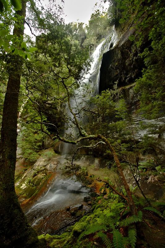
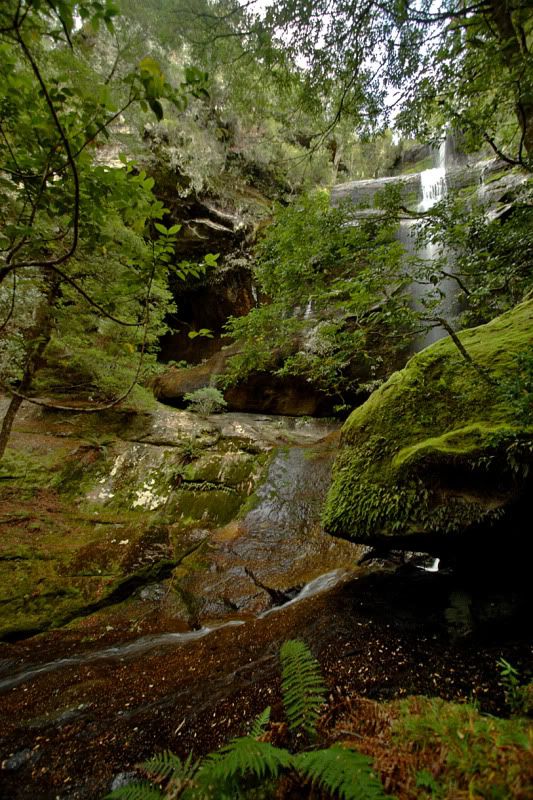
I was passing through the area for work yesterday and dropped in at St Columba Falls (how convenient.......I have a change of clothes and sneakers with me in the car!). It was a perfect day and plenty of water was coming over the top. It's only a 5-10 minute walk to the viewing platform and I still had plenty of spare time so decided to make my way through the scrub up to the top of the falls where I spent a very relaxing 60min or so before heading back to the car and off to my next client!
Note to self......be sure to book 2 hours of annual leave in my timesheet for the excursion
Note to self......be sure to book 2 hours of annual leave in my timesheet for the excursion
- Attachments
-
- St Columba Falls from the base
-
- River and gorge at the top of the falls
-
- Looking down - 90m drop! (or thereabouts)
-
Phil - Phyllocladus aspleniifolius

- Posts: 695
- Joined: Mon 25 Aug, 2008 2:06 pm
- Location: Launceston
- Region: Tasmania
- Gender: Male
Re: waterfall bagging
![]() by biggc » Thu 09 Jul, 2009 11:06 am
by biggc » Thu 09 Jul, 2009 11:06 am
thanks phil nice pics we have a shack at binalong bay and do these falls about 4 or 5 times a year they would have to be one of my favourites. Ralph falls and halls falls are not too far from there either.
- biggc
- Nothofagus gunnii
- Posts: 46
- Joined: Sat 18 Apr, 2009 8:30 am
- Region: Tasmania
50 posts
• Page 1 of 2 • 1, 2
Who is online
Users browsing this forum: No registered users and 39 guests