Is Sharpes Falls in or out of the Mt Field National Park?
Or is in an undisturbed Forestry Land?
Anyone know of any issues accessing this fall?
And how does this compare to accessing Marriot Falls lower and upper?
Sharpes Falls
Forum rules
Tasmania specific bushwalking discussion. Please avoid publishing details of access to sensitive areas with no tracks.
Tasmania specific bushwalking discussion. Please avoid publishing details of access to sensitive areas with no tracks.
7 posts
• Page 1 of 1
Sharpes Falls
![]() by wander » Fri 15 Jan, 2016 2:05 pm
by wander » Fri 15 Jan, 2016 2:05 pm
- wander
- Phyllocladus aspleniifolius

- Posts: 883
- Joined: Mon 26 Oct, 2009 11:19 am
- Region: South Australia
- Gender: Male
Re: Sharpes Falls
![]() by Caedo12 » Sun 19 Jun, 2016 10:34 pm
by Caedo12 » Sun 19 Jun, 2016 10:34 pm
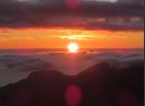
I made it to Sharpes Falls a couple of weeks ago. Certainly not easy but well worth it!
Turn off onto Newbury Road a few kilometres past Mt Field, cross over the Tyenna River, and then park at a locked gate a little ways past the bridge. The sign says that there is no entry beyond this point, but the waterfall itself is on a public reserve (not national park), so there isn't really any issue walking on along the road. There are a few 4WD tracks branching off the main road, but it isn't too difficult to figure out which way to go, up until there is a fork in the road where two equally significant roads branch off from each other. Head left here, and walk for about another 5 minutes, before a side road heads off sharply to the left. Go down this one for about 100 metres, before meeting up with some 4WD track. Turn right, and then head right again into the bush maybe 20 metres further along. There are some ribbons tied to trees once you get into the forest, but finding the right spot to enter it is tricky. The route to the base of the falls is completely undeveloped, and very steep and slippery towards the end (similar to the Quaile Falls trail except a bit worse) but the view of the falls makes the effort all seem worthwhile.
Certainly a fun adventure to be had!
- Attachments
-
- Sharpes Falls
-
- Landscape Shot
-

Caedo12 - Athrotaxis cupressoides

- Posts: 128
- Joined: Sat 14 May, 2016 5:35 pm
- Region: Tasmania
- Gender: Male
Re: Sharpes Falls
![]() by naturelover » Wed 11 Oct, 2017 5:40 pm
by naturelover » Wed 11 Oct, 2017 5:40 pm
Hey, thanks Credo for this information. I hope to tackle these fairly soon
-

naturelover - Athrotaxis cupressoides
- Posts: 291
- Joined: Mon 23 Apr, 2012 7:07 pm
- Region: Tasmania
- Gender: Female
Re: Sharpes Falls
![]() by north-north-west » Thu 12 Oct, 2017 8:06 am
by north-north-west » Thu 12 Oct, 2017 8:06 am
Roads and track shown on ListMaps (even the sat images) seem to follow that route for a while - except it shows fewer sideroads, and the falls are to the left (west or south) of the road when driving in, not the right . . . you must cross the creek somewhere downstream to get that side of the falls. But it would have to be a fairly new set of roads not to be shown on the sat images.
- Attachments
-
-
"Mit der Dummheit kämpfen Götter selbst vergebens."
-

north-north-west - Lagarostrobos franklinii

- Posts: 15120
- Joined: Thu 14 May, 2009 7:36 pm
- Location: The Asylum
- ASSOCIATED ORGANISATIONS: Social Misfits Anonymous
- Region: Tasmania
Re: Sharpes Falls
![]() by Caedo12 » Sat 14 Oct, 2017 4:08 pm
by Caedo12 » Sat 14 Oct, 2017 4:08 pm
In terms of the number of roads, there are a couple of more minor roads that aren't on the map (probably because they only go a short distance in to access the logging areas). At any rate, that doesn't really matter as it's pretty hard to confuse them with the main road, so forget I mentioned it.
Reading over what I posted before the directions aren't quite right, and I'll post a screenshot of a makeshift drawn route I put together. Once you head down the side road and reach the 4WD track you turn left, which I didn't mention before, before making the right turn I mentioned about 10 metres later near a small pile of dirt (which may or may not still be there). Hopefully the picture clears it up:
Reading over what I posted before the directions aren't quite right, and I'll post a screenshot of a makeshift drawn route I put together. Once you head down the side road and reach the 4WD track you turn left, which I didn't mention before, before making the right turn I mentioned about 10 metres later near a small pile of dirt (which may or may not still be there). Hopefully the picture clears it up:
- Attachments
-
-
Caedo12 - Athrotaxis cupressoides
- Posts: 128
- Joined: Sat 14 May, 2016 5:35 pm
- Region: Tasmania
- Gender: Male
Re: Sharpes Falls
![]() by north-north-west » Sat 14 Oct, 2017 4:56 pm
by north-north-west » Sat 14 Oct, 2017 4:56 pm
That makes more sense. Looks like you turn near where than obvious rectangular coupe is in the sat image. Then turn downstream and then turn off to pick up the marked route. Thanks.
"Mit der Dummheit kämpfen Götter selbst vergebens."
-
north-north-west - Lagarostrobos franklinii
- Posts: 15120
- Joined: Thu 14 May, 2009 7:36 pm
- Location: The Asylum
- ASSOCIATED ORGANISATIONS: Social Misfits Anonymous
- Region: Tasmania
Re: Sharpes Falls
![]() by L_Cham_67 » Thu 12 Jul, 2018 1:34 pm
by L_Cham_67 » Thu 12 Jul, 2018 1:34 pm
Went to have a look at Sharpes Falls earlier today. I took my bike to avoid a road walk up Newbury road and found the boom gate open! Turns out I rode into an active logging site which put an end to my plans...
EDIT: Here's a pic of what I came across. I went a little further and saw moving machinery in the distance so thought it'd be best to get outta there
EDIT: Here's a pic of what I came across. I went a little further and saw moving machinery in the distance so thought it'd be best to get outta there
- Attachments
-
-
L_Cham_67 - Athrotaxis selaginoides

- Posts: 1045
- Joined: Thu 17 Dec, 2015 6:43 pm
- Region: Tasmania
- Gender: Male
7 posts
• Page 1 of 1
Who is online
Users browsing this forum: No registered users and 26 guests