Mother Cummings Peak/Head - Abel? And the Valley access...

Tasmania specific bushwalking discussion.
Forum rules
Tasmania specific bushwalking discussion. Please avoid publishing details of access to sensitive areas with no tracks.

Mother Cummings Peak/Head - Abel? And the Valley access...

Postby headwerkn » Sun 27 May, 2018 9:13 pm

Hi all,

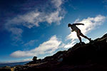
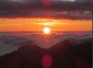
Headed up Mother Cummings Head earlier today, via the Smoko Rd/Mother Cummings Creek... initially in heavy mist as seems to happen every time I summit a mountain lately (!), but after hiding under the alpine heath for a bit and recharging with a cup of tea, the heaven's cleared and good (if hazy) views were to be had. Not a bad way to spend a Sunday.

Some questions if I may. First, is the southern summit/peak/trig point the Peak or the Head? Because literally, every map I've seen varies on this. Probably the majority say the northern, more pronounced peak is the Head and the southern, less pronounced but higher peak the Head, but I've seen the reverse on some maps online too.

33534204_10157346855057542_8858467676901605376_n.jpg
The 'northern' Peak


Secondly, which one's the official Abel? Again, seems to be some variance on this... the 'official' (aka. book) site refers to Cummings Head, however plenty of other sites refer to the Peak.

And lastly, does the 'Valley' track, approximately 2/3rds up the Creek track, provide a good route up to the northern peak? I had planned to reach both peaks (thus negating the previous questions!) but decided not to push my luck with the weather and limited afternoon light, and save it for another day. I'm assuming the Valley track continues up along the rivulet to the south-west side of the peak - is this a recommended approach? Or is it better to take the ridge from the south summit to the north and back? Or the northern track from Westrope Road?

30806362_10157346865922542_1740502476995428352_n.jpg
View west from Southern Peak, showing 'the valley' below leading right towards the Northern Peak (lost in mist)


33653566_10157346856322542_172738486518939648_n.jpg
Southern summit - initially found via electronic means due to < 50m visibility


33696485_10157346869567542_4376116317896310784_n.jpg
Marked access point for the 'Valley track'


Cheers, Ben.
User avatar
headwerkn
Phyllocladus aspleniifolius
 
Posts: 628
Joined: Sat 09 Nov, 2013 3:50 pm
Region: Tasmania
Gender: Male

Re: Mother Cummings Peak/Head - Abel? And the Valley access.

Postby L_Cham_67 » Sun 27 May, 2018 9:50 pm

As far as I'm aware, the southern peak (or in this case, head) is the Abel. If you look on LISTmap, you'll find that Cummings Head is located at the southern end, and the Abels book calls it 'Cummings Head'. But yes, it does cause confusion ;)
User avatar
L_Cham_67
Athrotaxis selaginoides
 
Posts: 1045
Joined: Thu 17 Dec, 2015 6:43 pm
Region: Tasmania
Gender: Male

Re: Mother Cummings Peak/Head - Abel? And the Valley access.

Postby north-north-west » Mon 28 May, 2018 9:07 am

Some of the confusion is due to official name changes. I've always refered to it simply as Mother Cummings, with the understanding that the higher southern point is the Abel. That's the thing with Abels - if there's higher ground without the 150m all round drop, then that higher bit is the Abel.

The Valley track does lead into the clear ground beside the creek and peters out there. There is a rough occasionally cairned pad that descends from the southern plateau to the clear ground in the saddle above the valley. Don't know if the pad continues beyond that to the northern peak. Slow going if it does. It would be quicker to go up from the valley or Westrope Rd.
"Mit der Dummheit kämpfen Götter selbst vergebens."
User avatar
north-north-west
Lagarostrobos franklinii
 
Posts: 15120
Joined: Thu 14 May, 2009 7:36 pm
Location: The Asylum
ASSOCIATED ORGANISATIONS: Social Misfits Anonymous
Region: Tasmania

Re: Mother Cummings Peak/Head - Abel? And the Valley access.

Postby Tortoise » Mon 28 May, 2018 9:27 am

As an aside, I thought Westrope Rd was still closed somewhere well short of the Mother Cummings track, due to some damage or other. Can't see it on the SST website, though. It may be worth checking if anyone plans to go that way.
User avatar
Tortoise
Lagarostrobos franklinii
 
Posts: 5158
Joined: Sat 28 Jan, 2012 9:31 pm
Location: NW Tasmania
Region: Tasmania
Gender: Female

Re: Mother Cummings Peak/Head - Abel? And the Valley access.

Postby teak » Mon 28 May, 2018 9:56 am

I went up Westrope Road last week and there is a road closed sign just past Syds track.
teak
Phyllocladus aspleniifolius
 
Posts: 719
Joined: Mon 02 Jan, 2012 10:33 am
Region: Tasmania
Gender: Male

Re: Mother Cummings Peak/Head - Abel? And the Valley access.

Postby Tortoise » Mon 28 May, 2018 5:40 pm

Thanks, Teak. Good to have the update.
User avatar
Tortoise
Lagarostrobos franklinii
 
Posts: 5158
Joined: Sat 28 Jan, 2012 9:31 pm
Location: NW Tasmania
Region: Tasmania
Gender: Female

Re: Mother Cummings Peak/Head - Abel? And the Valley access.

Postby Doonish » Fri 01 Jun, 2018 10:09 pm

I researched this question for the updated Abels book - there's a helpful summary at Placenames Tasmania.

This is the entry for Cummings Head:

"Assigned at Meeting Number 336: 19910912, over what had been mistakenly labelled Mother Cummings Peak, coordinates are reasonable. Administrative Note: Important - Cummings Head (to the south-east) and Mother Cummings Peak (to the north-west) are distinctly different features, and the history of the relative naming is quite confused, as some of the comments attributed to each feature's name could in fact relate to the other. Historical Note: Qualified by the previous admin note, the old card reads thus, Cummings Head shown on Plan 65 Westmorland by George Frankland 4th May 1837 and on his State Map. Copy of sketch of Cummings Head by W C Piguenit in Geology of Tasmania by R M Johnston 1888 (copy in M/537 Correspondence). Administrative Note: In effect, this name was mislaid between the 1830s and the 1990s."

I like the last bit. There's also some useful info under the entry for Mother Cummings Peak.

It's interesting too - if you look in Trove at references in early newspapers, "Cummings Head" turns up much earlier than any reference to "Mother Cummings Peak."
Doonish
Atherosperma moschatum
 
Posts: 54
Joined: Sat 15 Sep, 2012 12:19 pm
ASSOCIATED ORGANISATIONS: Fullers Bookshop
Region: Tasmania
Gender: Male


Return to Tasmania

Who is online

Users browsing this forum: No registered users and 28 guests