Dry's Bluff
Tasmania specific bushwalking discussion. Please avoid publishing details of access to sensitive areas with no tracks.
Dry's Bluff
![]() by wello » Sat 05 Apr, 2008 10:51 am
by wello » Sat 05 Apr, 2008 10:51 am
- wello
- Athrotaxis cupressoides

- Posts: 147
- Joined: Sat 05 Apr, 2008 10:43 am
Re: Dry's Bluff
![]() by tastrekker » Sat 05 Apr, 2008 12:07 pm
by tastrekker » Sat 05 Apr, 2008 12:07 pm
Past landowners have been happy for this and there was even a "Trespassers Welcome" sign on the gate. I'm not sure if this is still the case. If anyone knows anything different please let us know.
This is a great walk with approx. 1000 metres of altitude gain. Serious peak baggers will insist on pushing 3km south over the plateau to the highest point. Most groups are happy to make it to the trig point on the slightly lower but closer northern peak.
-

tastrekker - Athrotaxis cupressoides
- Posts: 498
- Joined: Thu 20 Sep, 2007 9:04 pm
- Location: Lenah Valley
- Region: Tasmania
- Gender: Male
Re: Dry's Bluff
![]() by wello » Sat 05 Apr, 2008 11:17 pm
by wello » Sat 05 Apr, 2008 11:17 pm
Apparantly that house and the "trespassers welcome" sign belong to Senator Bob Brown. Saw that in The Age, but there was no info on how to get to the start of the track.
Wello
- wello
- Athrotaxis cupressoides
- Posts: 147
- Joined: Sat 05 Apr, 2008 10:43 am
Re: Dry's Bluff
![]() by walkinTas » Sat 05 Apr, 2008 11:46 pm
by walkinTas » Sat 05 Apr, 2008 11:46 pm
- walkinTas
- Lagarostrobos franklinii

- Posts: 2934
- Joined: Thu 07 Jun, 2007 1:51 pm
- Region: Tasmania
Re: Dry's Bluff
![]() by Speculator » Sun 06 Apr, 2008 1:21 pm
by Speculator » Sun 06 Apr, 2008 1:21 pm
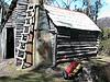
tastrekker wrote:Follow the Liffey Falls signs from the Bass Highway near Carrick. You will make a right turn in the middle of Bracknell then another right turn at a T-Junction near the old Liffey School. Soon after this, you cross the Liffey River as you enter bushland. 1.6km past this bridge, look for a driveway heading down to a small bridge and weatherboard house. Park near the main road, walk over the private property past the house and the track heads into the bush crossing a small creek before starting the relentless climb.
Past landowners have been happy for this and there was even a "Trespassers Welcome" sign on the gate. I'm not sure if this is still the case. If anyone knows anything different please let us know.
This is a great walk with approx. 1000 metres of altitude gain. Serious peak baggers will insist on pushing 3km south over the plateau to the highest point. Most groups are happy to make it to the trig point on the slightly lower but closer northern peak.
Sweet!
Thanks Tastrekker, and thanks to wello for posing the question. I didn't even know there was a track up there at all. There's another one added to the todo list!
Tastrekker - is the view as good as I'd imagine it to be?
L8r.
Peak bagging points: 10. Peak bagging bagging points: 10000.
-

Speculator - Optimus Imago

- Posts: 521
- Joined: Fri 15 Jun, 2007 10:35 pm
- Location: Ulverstone
- Region: Tasmania
Re: Dry's Bluff
![]() by tastrekker » Mon 07 Apr, 2008 6:42 am
by tastrekker » Mon 07 Apr, 2008 6:42 am
Speculator wrote:Tastrekker - is the view as good as I'd imagine it to be?
Yes, the view is amazing. From the northern peak, the start of the track looks like it is almost vertically below you. The view extends right over the northerm Midlands and lower Meander valley and is dominated by pasture lands and forestry operations (Cluan Tiers). To the south over the plateau, human intrusion is almost invisible.
From the southern summit, there are excellent views south over the plateau, down into the Liffey Falls area and right along the Tiers to the west.
Speculator wrote:I didn't even know there was a track up there at all.
If anyone wants something different, it is also possible to approach Drys Bluff using Westons Road. This is a locked Hydro road that heads NW from the top of the Poating Highway along to a canal and wiers on Westons Rivulet and Brumby's Creek. I have ridden a mountain bike along to the end of this wier. From this spot you are only 5km from the southern peak of Drys with only a modest climb required. On the day I rode along this way, there was quite a bit of snow so I did not continue on to the peak. I have heard of others doing this though by getting a key from the Hydro and driving to the end of the road.
-
tastrekker - Athrotaxis cupressoides
- Posts: 498
- Joined: Thu 20 Sep, 2007 9:04 pm
- Location: Lenah Valley
- Region: Tasmania
- Gender: Male
Re: Dry's Bluff
![]() by pkbgr » Mon 14 Apr, 2008 8:43 pm
by pkbgr » Mon 14 Apr, 2008 8:43 pm
- pkbgr
- Nothofagus gunnii

- Posts: 22
- Joined: Fri 19 Oct, 2007 1:55 pm
Re: Dry's Bluff
![]() by Speculator » Mon 14 Apr, 2008 8:54 pm
by Speculator » Mon 14 Apr, 2008 8:54 pm
pkbgr wrote:I'm leading a HWC walk there on Saturday, weather permitting
I hope you and the Hat Wearers Club get a good day for it then!
Peak bagging points: 10. Peak bagging bagging points: 10000.
-
Speculator - Optimus Imago
- Posts: 521
- Joined: Fri 15 Jun, 2007 10:35 pm
- Location: Ulverstone
- Region: Tasmania
Re: Dry's Bluff
![]() by flyfisher » Mon 14 Apr, 2008 9:10 pm
by flyfisher » Mon 14 Apr, 2008 9:10 pm
Whichever way, have a nice day. FF
-
flyfisher - Athrotaxis selaginoides

- Posts: 1532
- Joined: Sat 14 Jul, 2007 8:39 pm
- Location: hobart
- ASSOCIATED ORGANISATIONS: landrover owners club of tasmania
- Region: Tasmania
Re: Dry's Bluff
![]() by Speculator » Thu 29 May, 2008 3:21 pm
by Speculator » Thu 29 May, 2008 3:21 pm
pkbgr wrote:I'm leading a HWC walk there on Saturday, weather permitting
Hey pkbgr, did you end up doing this one? Was it as hard as The Abels suggests (one of Tassies most strenuous)?
L8r.
Peak bagging points: 10. Peak bagging bagging points: 10000.
-
Speculator - Optimus Imago
- Posts: 521
- Joined: Fri 15 Jun, 2007 10:35 pm
- Location: Ulverstone
- Region: Tasmania
Re: Dry's Bluff
![]() by rohjoe » Mon 09 Jun, 2008 7:16 pm
by rohjoe » Mon 09 Jun, 2008 7:16 pm
Hey pkbgr, did you end up doing this one? Was it as hard as The Abels suggests (one of Tassies most strenuous)?
I was fortunate to be one of pkbgr's party of six to Drys Bluff on 19/4, starting near the senator's place. It was a great day - the commanding views made the steep climb very worthwhile. The track to the trig is well worn & easy to follow. We went to the true summit which required some scrub bashing across the plateau; I think it helped to stay close to the edge of the escarpment on top. RJ.
-
rohjoe - Athrotaxis cupressoides
- Posts: 107
- Joined: Fri 04 Jan, 2008 8:40 pm
- Region: Tasmania
Re: Dry's Bluff
![]() by forthferalz » Fri 26 Sep, 2008 10:59 am
by forthferalz » Fri 26 Sep, 2008 10:59 am
ps anyone have aprox. return time for small slower person ( not 6 foot 2 person sized stride time ) to climb to the first peak?
- forthferalz
- Nothofagus gunnii
- Posts: 31
- Joined: Wed 19 Sep, 2007 8:19 pm
Re: Dry's Bluff
![]() by tastrekker » Fri 26 Sep, 2008 7:26 pm
by tastrekker » Fri 26 Sep, 2008 7:26 pm
forthferalz wrote:ps anyone have aprox. return time for small slower person ( not 6 foot 2 person sized stride time ) to climb to the first peak?
Something around 3 to 4 hours up and 2 to 3 hours down is respectable.
The spectacular sandstone rock formations are close to half way up. This is a great rest spot and the first spot where the views really start to open up. I always find it encouraging to reach this spot knowing the climb is half over and done with. Whatever time it takes to reach these is usually about half the time it will take to reach the "first peak."
-
tastrekker - Athrotaxis cupressoides
- Posts: 498
- Joined: Thu 20 Sep, 2007 9:04 pm
- Location: Lenah Valley
- Region: Tasmania
- Gender: Male
Re: Dry's Bluff
![]() by forthferalz » Fri 26 Sep, 2008 8:58 pm
by forthferalz » Fri 26 Sep, 2008 8:58 pm
- forthferalz
- Nothofagus gunnii
- Posts: 31
- Joined: Wed 19 Sep, 2007 8:19 pm
Re: Dry's Bluff
![]() by forthferalz » Thu 30 Oct, 2008 2:15 am
by forthferalz » Thu 30 Oct, 2008 2:15 am
-41.70342 146.82116
- forthferalz
- Nothofagus gunnii
- Posts: 31
- Joined: Wed 19 Sep, 2007 8:19 pm
Re: Dry's Bluff
![]() by tastrekker » Thu 30 Oct, 2008 6:22 am
by tastrekker » Thu 30 Oct, 2008 6:22 am
The track starts at the while weatherboard house here: -41.680364,146.824744 You need to park out on the road and follow the driveway up to the house. The driveway is marked on the GoogleMap. From the house, you head straight uphill to where a creek emerges from the bush. You cross the creek on a bridge and the walking track becomes more obvious after you enter the bush.
You may also be interested to know that the coordinated you posted in not the highest point. There is a trig point at your spot and that is where the most spectacular views are to be had out to the north.
The 'true summit' is located at the southern end of a long west-facing bluff. From the satellite image, I think it would be at : -41.715948, 146.804488. From this point the view down over boulder fields towards Liffey Falls is good and so is the view south to Great Lake. However, you lose the view to the north.
It was interesting to see that the walking track is visible on the satellite image where it crosses the rock scree below the northern 'named summit.'
Have fun. It's a long way up!
-
tastrekker - Athrotaxis cupressoides
- Posts: 498
- Joined: Thu 20 Sep, 2007 9:04 pm
- Location: Lenah Valley
- Region: Tasmania
- Gender: Male
Re: Dry's Bluff
![]() by forthferalz » Thu 30 Oct, 2008 7:32 pm
by forthferalz » Thu 30 Oct, 2008 7:32 pm
PS need distance traveled in one direction and is the track marked in any way? or just a footpad?
- forthferalz
- Nothofagus gunnii
- Posts: 31
- Joined: Wed 19 Sep, 2007 8:19 pm
Re: Dry's Bluff
![]() by MJD » Fri 31 Oct, 2008 8:05 am
by MJD » Fri 31 Oct, 2008 8:05 am
The notes that I have are:
Park 0485570E 5385875N. Cross the old bridge and the private property on the other side. The track starts directly behind the house and crosses a small bridge before heading up and up and up. If you lose the track then pick it up at 0484975E 5384175N before ascending to the sandstone cliffs. The plateau is reached at 0484945E 5383315N via a gully with a track continuing to the trig point at 0485420E 5383085N. Head directly across to the summit at 0483865E 5381940N 1352m and return along the cliff line to the gully. The other potential high points are 0484175E 5382244N 1349m and 0483805E 5381780N 1347m.
The heights are from my GPS which is usually to be about 8m higher than the AHD. I also used the barometer to compare the high points. I do have a gpx file if anyone is interested.
-

MJD - Athrotaxis selaginoides
- Posts: 1023
- Joined: Mon 26 May, 2008 11:24 pm
- Region: Tasmania
Re: Dry's Bluff
![]() by forthferalz » Fri 31 Oct, 2008 8:51 am
by forthferalz » Fri 31 Oct, 2008 8:51 am
- forthferalz
- Nothofagus gunnii
- Posts: 31
- Joined: Wed 19 Sep, 2007 8:19 pm
Re: Dry's Bluff
![]() by MJD » Fri 31 Oct, 2008 9:15 am
by MJD » Fri 31 Oct, 2008 9:15 am
My camera batteries died while I was in the sandstone cliffs so I don't have any photos of the top.
-
MJD - Athrotaxis selaginoides
- Posts: 1023
- Joined: Mon 26 May, 2008 11:24 pm
- Region: Tasmania
Re: Dry's Bluff
![]() by AddisonPascal » Sat 23 Dec, 2017 3:54 pm
by AddisonPascal » Sat 23 Dec, 2017 3:54 pm
- AddisonPascal
- Nothofagus cunninghamii

- Posts: 1
- Joined: Sat 23 Dec, 2017 3:52 pm
- Region: Tasmania
- Gender: Male
Who is online
Users browsing this forum: No registered users and 27 guests