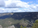
I have been familiarising myself with the various Schedule 1 Forbidden Zones in the Warragamba catchment with a view towards a short jaunt from Wattle Ridge down the Nattai Road and ultimately popping out at Thirlmere Lakes National Park. Sadly, there is about 8km total of track on this route which falls within the Forbidden Zone, which Sydney Water would have us believe is bristling with 3G trail cams and security patrols ready to apprehend any errant bushwalkers and hit them with $eleventythousand fines simply for walking along those 8km of track.
It's a beautiful, scenic and historic route, which I believe should be open to bushwalkers. The northern and southern bits of the Burragorang Valley Forbidden Zones have bushwalker's corridors so I wonder how many hoops would need to be jumped through to get a further corridor established for that particular route, so we may legally bushwalk those 8km through the Forbidden Zone? Was anyone on the forum involved in getting the existing bushwalker's corridors implemented? I'd be interested to hear how you did it.
Personally I find it ridiculous that there isn't some sort of easy-to-get permit system for bushwalkers to walk through the Forbidden Zones outside the existing Bushwalker's Corridors. As we all know, bushwalking by responsible walkers is about as low-impact an activity as you'll find. The risk of contamination of the water supply by bushwalkers passing through is laughably miniscule. Then of course there's the fact that the Cox's and the Nattai rivers receive treated sewage and contaminated stormwater which flows straight into the lake, and ultimately out of Sydneyfolk's taps, which renders all the powers that be's concerns about someone harming Sydney's water quality by bushwalking next to the water completely and utterly invalid.
And while I'm whingeing about the Forbidden Zones, I read with interest that they are planning on raising the Warragamba dam(n) wall, which will back up the waters even further and probably turn the Nattai River below Starlights into an unhealthy, sewage-contaminated lake. Sure, it'll mean I can take prettier pictures from the various lookouts on the plateau, but they will also envoke their magical 3-point-whatever-it-is km exclusion zone around the water line, so all Nattai valley access to the Joorilands area Bushwalker's Corridor and Yerranderie beyond will be lost.
Bushwalker's Corridors through the Forbidden Zones...
Forum rules
NSW & ACT specific bushwalking discussion. Please avoid publishing details of access to sensitive areas with no tracks.
NSW & ACT specific bushwalking discussion. Please avoid publishing details of access to sensitive areas with no tracks.
26 posts
• Page 1 of 1
Bushwalker's Corridors through the Forbidden Zones...
![]() by Bushman_Craig » Thu 21 Jun, 2018 3:25 pm
by Bushman_Craig » Thu 21 Jun, 2018 3:25 pm
- Bushman_Craig
- Atherosperma moschatum

- Posts: 67
- Joined: Mon 05 Sep, 2016 4:30 pm
- Region: New South Wales
- Gender: Male
Re: Bushwalker's Corridors through the Forbidden Zones...
![]() by Grabeach » Thu 21 Jun, 2018 7:57 pm
by Grabeach » Thu 21 Jun, 2018 7:57 pm
Decades back I recall being at Water Board presentation to a bushwalking club. The Board gave the impression the presentation was to be about opening up the 3 km area to walkers among others. Turned out it was only about introducing the Beloon Pass or whatever its called corridor. The board spokesman gave water quality as the reason to retain the 3 km, but had difficulty reconciling this with our examples of the various pollution sources within the catchment. In private afterwards he admitted that the real reason for the 3 km was to prevent fires occurring near the shoreline resulting in complaints by consumers about the colour of the water coming out of their taps. I assume this reasoning still applies. At least there is some logic in this, unlike my pet hate of the restrictions on cyclists on formed roads up on the plateaus nowhere near the dam.
- Grabeach
- Athrotaxis cupressoides

- Posts: 309
- Joined: Wed 12 Oct, 2011 2:09 pm
- Region: New South Wales
- Gender: Male
Re: Bushwalker's Corridors through the Forbidden Zones...
![]() by LachlanB » Thu 21 Jun, 2018 8:53 pm
by LachlanB » Thu 21 Jun, 2018 8:53 pm
Grabeach wrote:In private afterwards he admitted that the real reason for the 3 km was to prevent fires occurring near the shoreline resulting in complaints by consumers about the colour of the water coming out of their taps.
I'd happily forgo campfires within the 3km exclusion zone in exchange for being able to walk in it...
- LachlanB
- Athrotaxis cupressoides
- Posts: 381
- Joined: Mon 21 Apr, 2014 5:07 pm
- Region: New South Wales
- Gender: Male
Re: Bushwalker's Corridors through the Forbidden Zones...
![]() by michael_p » Fri 22 Jun, 2018 1:39 pm
by michael_p » Fri 22 Jun, 2018 1:39 pm
We'd all like to walk in the forbidden zone but alas it is not to be. There are good reasons for this. The Water Board person was on the right track as sedimentation of materials in the lake is the major method for cleaning the water before it gets to the dam. The water moves at a very slow rate and is surprisingly clean by the time it gets to the dam and doesn't need much more processing before being distributed to households.
We all should be extremely thankful for Warragamba as it is the reason we have so many excellent NPs to enjoy.
A far bigger problem is the dam wall raising. Good chance the property developers who want to rezone all the flood plain along the Nepean/Hawkesbury River will get thier way.
Cheers,
Michael.
One foot in front of the other.
-
michael_p - Athrotaxis selaginoides

- Posts: 1378
- Joined: Sun 15 Nov, 2009 6:58 pm
- Location: Macarthur Region of Sydney.
- Region: New South Wales
- Gender: Male
Re: Bushwalker's Corridors through the Forbidden Zones...
![]() by Wollemi » Fri 22 Jun, 2018 2:12 pm
by Wollemi » Fri 22 Jun, 2018 2:12 pm
"...sedimentation of materials in the lake is the major method for cleaning the water before it gets to the dam." Chifley Dam supplies 100% of the potable water to the city of Bathurst, yet sediment-inducing water-skiing is encouraged. The pretty Lake Oberon supplies all of the drinking water to the adjacent town - and to upper Blue Mts townships, yet I was kayaking on it as I watched cattle stand and drink in it (June 2017).
Live everyday as if it were your last... one day you will be right.
- Wollemi
- Athrotaxis cupressoides
- Posts: 275
- Joined: Tue 24 Jul, 2012 10:32 am
- Location: lower Blue Mts
- Region: New South Wales
- Gender: Male
Re: Bushwalker's Corridors through the Forbidden Zones...
![]() by Bushman_Craig » Sat 23 Jun, 2018 12:13 pm
by Bushman_Craig » Sat 23 Jun, 2018 12:13 pm
@Wollemi, Chifley Dam and Lake Oberon aren't (yet) run by whatever for-profit corporation replaced the NSW Water Board, but I'll bet one of the family jewels they will be sooner or later. These types of vital once-public utilities are such a cash cow for these corporations and their shareholders.
The national parks surrounding the Forbidden Zones were planned long before they flooded the Burragorang Valley. Warragamba Dam isn't to thank for these parks, conservationists such as Myles Dunphy and Alex Colley from back in the day are the ones we should be thanking since they planned out and lobbied hard for these areas to be protected and gazetted as national parks.
I was reading the Nattai Reserves management plan again the other day. This document dates from 2001, well before the Sydney Catchment Authority was replaced by whatever for-profit corporation replaced it, but I understand the plan is still in operation.
This NPWS document mentions that out of the whole Nattai Reserves system (comprising the Nattai NP, Bargo SCA, Burrograng SCA, Nattai SCA and Yerranderie SCA) 75% falls within the Schedule One area AKA the Forbidden Zone where some for-profit corporation is able to have you fined within an inch of homelessness if all their scary signs out there are to be believed.
This is all going over old ground again. Organisations such as the Colong Foundation and the Confederation of Bushwalking Clubs of NSW have lobbied for very low impact bushwalker access to these areas time and again, and time and again such access has been granted then revoked for operational reasons, then granted again, then revoked again. Now it seems no-one is interested in maintaining bushwalker access to historic tracks within the Forbidden Zone.
Both Francis Barrallier and Governor Lachlan Macquarie entered the Burragorang/Nattai Valley system via what is now Sheehys Creek Road. Barrallier first recorded the use of the "coo-ee" by the local Dhaurg people and guess where he heard it? Near the junction of the Nattai and Little Rivers. I won't even mention the various Indigenous Songlines which exist in the valley system and surrounds. Can we sit in quiet contemplation by the water at the same Nattai/Little River junction and imagine the valley as Barrallier first saw it in 1790s? Nope. Forbidden. An historic location denied to the Australian people by a for-profit corporation which has inexplicably been granted statutory authority status by an Australian state government, but can pretty much do as they like because they have a monopoly. That's just one example of the social importance of the area.
Solution? I'd like to see the NSW Water Minister's office grant regular specific permits for bushwalkers or parties of bushwalkers to transit the various tracks and trails in the Forbidden Zones with "self-reliant recreation" being an acceptable reason. Obviously there would have to be quite stringent conditions attached such as no camping or fires within the Schedule One area as with the bushwalker's corridors. There would be fees payable ("for-profit" corporations only understand money after all), and identifiable details of the party and its memberships recorded by the Minister's office or some other agency like NPWS or NSWPOL in case of irresponsible or ignorant meetup.org "bushwalking" groups deciding they'd like to walk these tracks.
I don't think it'd be too difficult and all stakeholders' interests could be served by such a system of access permits.
- Bushman_Craig
- Atherosperma moschatum
- Posts: 67
- Joined: Mon 05 Sep, 2016 4:30 pm
- Region: New South Wales
- Gender: Male
Re: Bushwalker's Corridors through the Forbidden Zones...
![]() by Lophophaps » Sat 23 Jun, 2018 4:35 pm
by Lophophaps » Sat 23 Jun, 2018 4:35 pm
I don't know the region. Is it likely to attract many people, small or large parties, newbies blundering or experienced people complying with established and accepted bushwalking ways?
Between Murray Gap and Cotter Gap the AAWT crosses part of the catchment for Canberra's water supply. This is 14 kilometres, and can be crossed in a day from Oldfields Hut to Sawpit Creek, about 19 kilometres. Camping on the Victorian side of Murray Gap and just inside the catchment at Cotter Gap make this an easy day. Permits are required, and ACT PWS seem to readily give these out to small parties of experienced people. I gather that most parties attempt to camp outside or at the edges of the catchment.
Given all the contamination cited above I cannot see why bushwalkers are denied entry. Maybe list the contamination and say that bushwalkers are in small numbers, and hence have a tiny impact compared to the rest. Ask for solid evidence.
If this is not supplied then several remedies exist. I've used this approach in Victoria and it works a treat.
-

Lophophaps - Auctorita modica

- Posts: 3382
- Joined: Wed 09 Nov, 2011 9:45 am
- Region: Victoria
- Gender: Male
Re: Bushwalker's Corridors through the Forbidden Zones...
![]() by rcaffin » Sun 24 Jun, 2018 5:42 pm
by rcaffin » Sun 24 Jun, 2018 5:42 pm
There is another reason why the Water Board do not want walkers in that area. Butchers Creek and Green Wattle creek must have several hundred cows and horses in the lower parts of those valleys, and even more pigs and goats. If this became widely known the 'public' would demand that they were cleaned out to avoid the massive contamination they create. But that would deprive some vested interests of their quiet and illegal stock supply.
Butchers Creek is the source of the stock which regularly strays over Scotts Main Range into the Kowmung valley. Up and over is very easy walking. The NPWS has to routinely muster them in the Kowmung and remove them.
A rather interesting observation. There is an obvious spur which runs from Scotts down to Butchers. It is trail-marked for horse riding and horseshoe marks have been seen going down the spur. Someone checking on their stock supply?
The above estimates are NOT blind guesses. At the risk of encouraging illegal activities, I suggest doubters go and look for themselves. The lower end of Butchers stinks. If you do go, take LOTS of photos, and do not surrender them.
Cheers
Roger
-

rcaffin - Athrotaxis selaginoides
- Posts: 1225
- Joined: Thu 17 Jul, 2008 3:46 pm
Re: Bushwalker's Corridors through the Forbidden Zones...
![]() by LachlanB » Sun 24 Jun, 2018 6:10 pm
by LachlanB » Sun 24 Jun, 2018 6:10 pm
Bushman_Craig wrote:Solution? I'd like to see the NSW Water Minister's office grant regular specific permits for bushwalkers or parties of bushwalkers to transit the various tracks and trails in the Forbidden Zones with "self-reliant recreation" being an acceptable reason. Obviously there would have to be quite stringent conditions attached such as no camping or fires within the Schedule One area as with the bushwalker's corridors. There would be fees payable ("for-profit" corporations only understand money after all), and identifiable details of the party and its memberships recorded by the Minister's office or some other agency like NPWS or NSWPOL in case of irresponsible or ignorant meetup.org "bushwalking" groups deciding they'd like to walk these tracks.
I don't think it'd be too difficult and all stakeholders' interests could be served by such a system of access permits.
I agree with you in principle; that there should be an avenue for public access to these areas.
But I couldn't disagree with your proposed mechanism for providing that access more!
These tracks and areas are on public land, and access to them has been closed for no justifiable reason (from my perspective, anyway). Why should camping, which is acceptable within the constraints of MIB be prohibited? Why shouldn't walkers be allowed to walk off-track, an activity that often has lesser impacts than forming an eroding trail? Why should access be restrained to members of bushwalking clubs on club trips, excluding the vast majority of bushwalkers? Why shouldn't meetup style walking groups have access? And also, why should walkers have to pay for an access permit to public land?
The best eventual solution I could envisage is the complete removal of the exclusion zones for bushwalkers. Acknowledging this is unlikely to happen, a good outcome would be a digital register- telling the Water Board who is walking, when the walk is, where the walk is going, any bushwalking club affiliations, and contact details of walk leader as well as an emergency contact. On filling this out, walkers acquire automatic permission to enter the exclusion zone, unless the Water Board requests supporting details on how impacts on water quality can be avoided. It's not the job of the Water Board to be assessing if a walker is capable of completing a walk or not... I've loosely based the register suggestion on the system used by NPWS for caving, canyoning and walking at Bungonia NP, which seems to work.
- LachlanB
- Athrotaxis cupressoides
- Posts: 381
- Joined: Mon 21 Apr, 2014 5:07 pm
- Region: New South Wales
- Gender: Male
Re: Bushwalker's Corridors through the Forbidden Zones...
![]() by Lophophaps » Sun 24 Jun, 2018 9:34 pm
by Lophophaps » Sun 24 Jun, 2018 9:34 pm
Publicity about the matter backed with solid evidence could work. Let the facts speak.
-
Lophophaps - Auctorita modica
- Posts: 3382
- Joined: Wed 09 Nov, 2011 9:45 am
- Region: Victoria
- Gender: Male
Re: Bushwalker's Corridors through the Forbidden Zones...
![]() by LachlanB » Sun 24 Jun, 2018 10:05 pm
by LachlanB » Sun 24 Jun, 2018 10:05 pm
Lophophaps wrote:Publicity about the matter backed with solid evidence could work. Let the facts speak.
How do you argue with the water quality claims though?
WaterNSW wrote:Public access to the Special and Controlled Areas is restricted to protect water quality. This helps create a buffer of land around water storages and infrastructure which act as a filter for water quality, restricts harmful activities and helps us manage the resources.
This protects and preserves:
- Water quality used by over four million residents
- Critical water supply infrastructure for Greater Sydney
- Natural and cultural heritage
(my emphasis)
I can claim that small numbers of bushwalkers following minimal impact bushwalking ethics will have negligible impact on the catchment, especially when compared to WaterNSW's network of firetrails, until I'm blue in the face. But as soon as WaterNSW claims that they're protecting the integrity of the catchment, won't any argument be lost?
- LachlanB
- Athrotaxis cupressoides
- Posts: 381
- Joined: Mon 21 Apr, 2014 5:07 pm
- Region: New South Wales
- Gender: Male
Re: Bushwalker's Corridors through the Forbidden Zones...
![]() by Grabeach » Sun 24 Jun, 2018 10:36 pm
by Grabeach » Sun 24 Jun, 2018 10:36 pm
When it was the Water Board, they controlled the whole system from catchment to your tap. If the replacement Sydney Catchment Authority had their way the whole Restricted Area would have been No Entry. Mt Solitary would have been off limits. When it was the Water Board, catchments were only one part of their operation, hence anecdotal evidence suggests they were more lenient about the occasional intrusion into the No Entry area. When created the SCA's sole purpose in life was to control catchment areas, hence they have resisted anything that lessons their authority. Whether there is any change now that they are part of WaterNSW, I do not know. Just don't hold your breath.
- Grabeach
- Athrotaxis cupressoides
- Posts: 309
- Joined: Wed 12 Oct, 2011 2:09 pm
- Region: New South Wales
- Gender: Male
Re: Bushwalker's Corridors through the Forbidden Zones...
![]() by Walk_fat boy_walk » Mon 25 Jun, 2018 9:40 am
by Walk_fat boy_walk » Mon 25 Jun, 2018 9:40 am
rcaffin wrote:There is another reason why the Water Board do not want walkers in that area. Butchers Creek and Green Wattle creek must have several hundred cows and horses in the lower parts of those valleys, and even more pigs and goats. If this became widely known the 'public' would demand that they were cleaned out to avoid the massive contamination they create. But that would deprive some vested interests of their quiet and illegal stock supply.
Butchers Creek is the source of the stock which regularly strays over Scotts Main Range into the Kowmung valley. Up and over is very easy walking. The NPWS has to routinely muster them in the Kowmung and remove them.
A rather interesting observation. There is an obvious spur which runs from Scotts down to Butchers. It is trail-marked for horse riding and horseshoe marks have been seen going down the spur. Someone checking on their stock supply?
Had no idea about any of this! Probably a naive question (and I think just circling around the point your making) but I thought the NP boundary extended all the way to the lakeshore, which begs the question why NPWS wait for the stock to cross SMR before removing them? Are NPWS also denied entry to the SCA area or is the implication that there is dodgyness on all sides?
- Walk_fat boy_walk
- Lagarostrobos franklinii

- Posts: 2087
- Joined: Sat 21 Nov, 2009 6:59 am
- Gender: Male
Re: Bushwalker's Corridors through the Forbidden Zones...
![]() by Lophophaps » Mon 25 Jun, 2018 7:13 pm
by Lophophaps » Mon 25 Jun, 2018 7:13 pm
The Sydney Catchment Authority may fall under Freedom of Information
https://www.service.nsw.gov.au/accessing-information
SCA seems to be Water NSW
https://www.waternsw.com.au/about/who-we-are
If FOI applies, then asking for the water quality readings may bear fruit. I used FOI to get the Falls Hotham submissions published, worked well. Shining a light on darkness is good.
-
Lophophaps - Auctorita modica
- Posts: 3382
- Joined: Wed 09 Nov, 2011 9:45 am
- Region: Victoria
- Gender: Male
Re: Bushwalker's Corridors through the Forbidden Zones...
![]() by north-north-west » Tue 03 Jul, 2018 10:43 am
by north-north-west » Tue 03 Jul, 2018 10:43 am
Given the latest legislation, I think you might want to think again about public protests. Or even challenging the gov't on this.
"Mit der Dummheit kämpfen Götter selbst vergebens."
-

north-north-west - Lagarostrobos franklinii
- Posts: 15119
- Joined: Thu 14 May, 2009 7:36 pm
- Location: The Asylum
- ASSOCIATED ORGANISATIONS: Social Misfits Anonymous
- Region: Tasmania
Re: Bushwalker's Corridors through the Forbidden Zones...
![]() by rcaffin » Wed 04 Jul, 2018 4:37 pm
by rcaffin » Wed 04 Jul, 2018 4:37 pm
I thought the NP boundary extended all the way to the lakeshore, which begs the question why NPWS wait for the stock to cross SMR before removing them? Are NPWS also denied entry to the SCA area or is the implication that there is dodgyness on all sides?
A very interesting Q. I don't know.
It may be that the NPWs feels pressured to deal with the Kowmung valley because it is open to bushwalkers who get to SEE the stock, while Butchers Creek is closed and 'no-one knows'. Mind you, this approach might also sit comfortably with certain vested interests.
Cheers
-
rcaffin - Athrotaxis selaginoides
- Posts: 1225
- Joined: Thu 17 Jul, 2008 3:46 pm
Re: Bushwalker's Corridors through the Forbidden Zones...
![]() by Hughmac » Wed 04 Jul, 2018 6:55 pm
by Hughmac » Wed 04 Jul, 2018 6:55 pm
Whole thing is a crock. I personally doubt that there is much surveillance on the tracks in question, or that they would have staff on call to catch transgressors. Given government staffing reductions there would be little chance of getting caught on a Sunday I reckon. I did once question a middle manager at Sydney Water about the restrictions on mountain bikes, and he said they have had a number of instances of groups of people tearing up areas in catchments to create tracks off road, although I don't see why this should preclude responsible riders. His advice to me if I ever got caught where I shouldn't be was to tell the individual in question I wasn't comfortable dealing with them and to walk away.
- Hughmac
- Athrotaxis cupressoides
- Posts: 154
- Joined: Sat 14 Apr, 2012 9:20 pm
- Region: New South Wales
Re: Bushwalker's Corridors through the Forbidden Zones...
![]() by LachlanB » Thu 05 Jul, 2018 10:15 am
by LachlanB » Thu 05 Jul, 2018 10:15 am
Hughmac wrote:His advice to me if I ever got caught where I shouldn't be was to (...) walk away.
Not advocating it, but what powers do NPWS and Sydney Water have to compel people to identify themselves and follow instructions? Sydney Water widely publicises that they conduct remote surveillance of the catchment area, but how does that help them identify a walker, one of millions of people in the state? Backpacks don't come with numberplates... Plus, if a walker was to be stopped by a patrol, could't you just do a 90-degree turn off the track into the bush, and keep walking until they gave up? It's not like a patrol could manhandle you into the back of their ute.
This document (http://www.environment.nsw.gov.au/resou ... s06172.pdf) would seem to indicate that both NPWS and Sydney Water can request your identity and address, with the possibility of arrest if you refuse to provide it.
- LachlanB
- Athrotaxis cupressoides
- Posts: 381
- Joined: Mon 21 Apr, 2014 5:07 pm
- Region: New South Wales
- Gender: Male
Re: Bushwalker's Corridors through the Forbidden Zones...
![]() by Hughmac » Thu 05 Jul, 2018 8:58 pm
by Hughmac » Thu 05 Jul, 2018 8:58 pm
They do have the power to demand your name and address, and arrest if you refuse or give obviously false details. I guess it would depend on the individual officer concerned and how far they are willing to go. I've never met anyone from NPWS who I think would detain you, but Sydney Water may be different. As you say, I can't imagine them using force to detain you if just calmly walked away. To be honest I'm seriously considering trying my luck come spring. If I do I'll just ensure I don't enter the area on the road and claim ignorance if I'm caught. As I said before, I doubt they are paying their staff to work Sundays, and as you say a random photo or video is no help to them.
- Hughmac
- Athrotaxis cupressoides
- Posts: 154
- Joined: Sat 14 Apr, 2012 9:20 pm
- Region: New South Wales
Re: Bushwalker's Corridors through the Forbidden Zones...
![]() by Grabeach » Thu 05 Jul, 2018 11:54 pm
by Grabeach » Thu 05 Jul, 2018 11:54 pm
If I do I'll just ensure I don't enter the area on the road .....
I think this was Wilf Hilder's theory. He always said that the only signs he ever saw were as he was leaving.
May be difficult with my pushy though.
- Grabeach
- Athrotaxis cupressoides
- Posts: 309
- Joined: Wed 12 Oct, 2011 2:09 pm
- Region: New South Wales
- Gender: Male
Re: Bushwalker's Corridors through the Forbidden Zones...
![]() by LachlanB » Fri 06 Jul, 2018 12:53 pm
by LachlanB » Fri 06 Jul, 2018 12:53 pm
Grabeach wrote:If I do I'll just ensure I don't enter the area on the road .....
I think this was Wilf Hilder's theory. He always said that the only signs he ever saw were as he was leaving.
That might be a bit more difficult now. Those signs seem to have multiplied like mushrooms over the last few years...
- LachlanB
- Athrotaxis cupressoides
- Posts: 381
- Joined: Mon 21 Apr, 2014 5:07 pm
- Region: New South Wales
- Gender: Male
Re: Bushwalker's Corridors through the Forbidden Zones...
![]() by climberman » Fri 06 Jul, 2018 5:43 pm
by climberman » Fri 06 Jul, 2018 5:43 pm
It's not Sydney Water (www.sydneywater.nsw.gov.au), they do retail water and wastewater.
It's WaterNSW, who used to be the Sydney Catchment Authority (but are NOT NSW Office of Water [NSW Water - who seem to be transitioning to Dept Industry - www.industry.nsw.gov.au/water]).
water, water, everywhere.....
It's WaterNSW, who used to be the Sydney Catchment Authority (but are NOT NSW Office of Water [NSW Water - who seem to be transitioning to Dept Industry - www.industry.nsw.gov.au/water]).
water, water, everywhere.....
- climberman
- Phyllocladus aspleniifolius

- Posts: 656
- Joined: Tue 09 Dec, 2008 7:32 pm
Re: Bushwalker's Corridors through the Forbidden Zones...
![]() by Hughmac » Fri 06 Jul, 2018 6:04 pm
by Hughmac » Fri 06 Jul, 2018 6:04 pm
Cheers Climberman, I can't keep up with the changes. Hi Grabeach. Don't know if you've been down Nattai Rd recently, but once you drop off the plateau you'd be hard pressed to ride very much of it. Hard to believe how recently it was still accessible to vehicles. It is very much just a walking track now.
- Hughmac
- Athrotaxis cupressoides
- Posts: 154
- Joined: Sat 14 Apr, 2012 9:20 pm
- Region: New South Wales
Re: Bushwalker's Corridors through the Forbidden Zones...
![]() by juxtaposer » Sun 08 Jul, 2018 9:12 am
by juxtaposer » Sun 08 Jul, 2018 9:12 am
Got caught camping at Cox/Kowmung junction one long ago Easter. The Water Board ranger spotted us from the White Dog Road. I remember filling the billy and hearing some strange noises above the sound of the river - it was the boss ranger yelling out to try and get our attention, which is what another ranger told us the next day when he confronted us while we were heading up the road. We pleaded the Wilf Hilder defence and got off with a warning. Some would know that Wilf used to call this area "grand country" because that's what the fine was.
The track Roger mentions from Scotts into Butchers Creek I'm pretty sure is an old bridle trail which I've followed sections of a couple of times. Saw no feral animals on the flats of lower Green Wattle or nearby valleys in the late 70s/early 80s, but did find horse feces in a saddle on a spur further up that valley on one occasion. I don't think there were any pigs in the mountains then. Didn't see any sign of goats either, other than on Wanganderry Tableland.
The track Roger mentions from Scotts into Butchers Creek I'm pretty sure is an old bridle trail which I've followed sections of a couple of times. Saw no feral animals on the flats of lower Green Wattle or nearby valleys in the late 70s/early 80s, but did find horse feces in a saddle on a spur further up that valley on one occasion. I don't think there were any pigs in the mountains then. Didn't see any sign of goats either, other than on Wanganderry Tableland.
- juxtaposer
- Athrotaxis cupressoides
- Posts: 196
- Joined: Thu 27 Jan, 2011 4:20 pm
- Region: New South Wales
Re: Bushwalker's Corridors through the Forbidden Zones...
![]() by juxtaposer » Sun 08 Jul, 2018 9:52 am
by juxtaposer » Sun 08 Jul, 2018 9:52 am
A couple of years before that, we actually camped next to the White Dog hut when there were three Water Board workers staying there. They invited us to use the outside fireplace and did some cooking with us. Nothing was said about being in a prohibited area and next morning they pointed out the best place for us to cross the river.
- juxtaposer
- Athrotaxis cupressoides
- Posts: 196
- Joined: Thu 27 Jan, 2011 4:20 pm
- Region: New South Wales
Re: Bushwalker's Corridors through the Forbidden Zones...
![]() by wildwanderer » Sun 08 Jul, 2018 10:58 am
by wildwanderer » Sun 08 Jul, 2018 10:58 am
delete.
-

wildwanderer - Athrotaxis selaginoides
- Posts: 1640
- Joined: Tue 02 May, 2017 8:42 am
- Location: Out of lockdown \o/
- Region: New South Wales
- Gender: Male
26 posts
• Page 1 of 1
Return to New South Wales & ACT
Who is online
Users browsing this forum: No registered users and 12 guests