Many years ago, I had gathered all the information and planned a trip to the source of the Murray River from Dead Horse Gap. Apparently there is a cairn the to mark the spot. This is in the Pilot Wilderness of Kosciusko NP.
Well unfortunately the trip didn't happen because there was unexpectedly several metres of snow over the Cascades Fire Trail. Somehow I forgot about it and have only just remembered my plan. Unfortunately, I have no idea where my notes are - been flooded twice since then and lost lots of valuable documents.
So I am wondering if anyone knows where the cairn is and how to get to it? From what I recall, it is near the wreck site of the Southern Cloud.
(PM me if you prefer.)
Thanks
David
Source of the Murray
Forum rules
NSW & ACT specific bushwalking discussion. Please avoid publishing details of access to sensitive areas with no tracks.
NSW & ACT specific bushwalking discussion. Please avoid publishing details of access to sensitive areas with no tracks.
38 posts
• Page 1 of 2 • 1, 2
Source of the Murray
![]() by davidmorr » Wed 30 Oct, 2013 10:18 pm
by davidmorr » Wed 30 Oct, 2013 10:18 pm
This post is copyright by davidmorr. Permission to reproduce elsewhere may be granted on application. Please PM me for details.
- davidmorr
- Athrotaxis cupressoides

- Posts: 448
- Joined: Tue 09 Feb, 2010 11:39 pm
- Location: Newcastle
- Region: New South Wales
- Gender: Male
Re: Source of the Murray
![]() by DarrenM » Thu 31 Oct, 2013 5:24 am
by DarrenM » Thu 31 Oct, 2013 5:24 am
Hi David,
The Southern Cloud is in the Northern end of KNP. Do a search for Kevin Moody, source of the Murray for an account of his trip. A packraft might be fun!
The Southern Cloud is in the Northern end of KNP. Do a search for Kevin Moody, source of the Murray for an account of his trip. A packraft might be fun!
- DarrenM
- Athrotaxis cupressoides
- Posts: 465
- Joined: Tue 19 Oct, 2010 7:10 pm
- Location: Sydney
- Region: New South Wales
- Gender: Male
Re: Source of the Murray
![]() by kanangra » Thu 31 Oct, 2013 7:30 am
by kanangra » Thu 31 Oct, 2013 7:30 am
You are thinking of the airforce wreck on the plain near the border. I forget what it is called.
K.
K.
- kanangra
- Athrotaxis selaginoides

- Posts: 1335
- Joined: Sun 25 May, 2008 3:52 pm
Re: Source of the Murray
![]() by davidmorr » Thu 31 Oct, 2013 7:38 am
by davidmorr » Thu 31 Oct, 2013 7:38 am
I was going by the name on the topo map.
This post is copyright by davidmorr. Permission to reproduce elsewhere may be granted on application. Please PM me for details.
- davidmorr
- Athrotaxis cupressoides
- Posts: 448
- Joined: Tue 09 Feb, 2010 11:39 pm
- Location: Newcastle
- Region: New South Wales
- Gender: Male
Re: Source of the Murray
![]() by kanangra » Thu 31 Oct, 2013 8:39 am
by kanangra » Thu 31 Oct, 2013 8:39 am
Cowombat Flat is i think the name of the area where the wreck is located. WW11as i recall.
K.
K.
- kanangra
- Athrotaxis selaginoides
- Posts: 1335
- Joined: Sun 25 May, 2008 3:52 pm
Re: Source of the Murray
![]() by wildwalks » Thu 31 Oct, 2013 8:53 am
by wildwalks » Thu 31 Oct, 2013 8:53 am
Been 20 years since I walked through Cowombat Flats -- loved the area.
I don't remember any cairns, but it is likely as there are bunch of cairns marking the straight line of the NSW VIC border.
The plane had a forced landing (crashed with style) in 1954 and was a RAAF owned Dakota
http://trove.nla.gov.au/ndp/del/article/57336880
Matt
I don't remember any cairns, but it is likely as there are bunch of cairns marking the straight line of the NSW VIC border.
The plane had a forced landing (crashed with style) in 1954 and was a RAAF owned Dakota
http://trove.nla.gov.au/ndp/del/article/57336880
Matt
-------------------
Bushwalking and Hiking tracknotes - Wildwalks
Bushwalking and Hiking tracknotes - Wildwalks
- wildwalks
- Magnus administratio

- Posts: 949
- Joined: Mon 22 Nov, 2010 4:35 pm
- ASSOCIATED ORGANISATIONS: Wildwalks, Bushwalk.com & NPA NSW
- Region: New South Wales
- Gender: Male
Re: Source of the Murray
![]() by Wollemi » Thu 31 Oct, 2013 1:58 pm
by Wollemi » Thu 31 Oct, 2013 1:58 pm
davidmorr wrote:...the source of the Murray River from Dead Horse Gap. Apparently there is a cairn the to mark the spot.
I visited this cairn about 1996. We cycled from DHG as far south as bicycles are allowed to be, then navigated on foot the next day. About 400m E from a curve in the Cowombat FT, blundering around a bit, to encounter the cairn - which exceeded 2.5m in height. Somewhat scrubbed in, difficult to photograph, and with no views nor water.
My friend had a copy of a printed publication that gave the co-ordinates.
Black-Allen line; http://www.dse.vic.gov.au/__data/assets ... n_Line.pdf
- pg 9 shows contemporary photos of cairns along the Black-Allen Line.
- pg 23 shows what you want;
Commencing at a Spring in latitude 36○ 47’ 56”.901 S and longitude 148○ 11’57”.752 E deduced from the latitude of the Melbourne Observatory taken as 37○49’53”.397 S and its longitude 144○58”40”.903 E which Spring is the source of the river Murray nearest to Cape Howe thence bearing S63○01’50.58” E
to a point on Forest Hill called Station No. 1 marked by a pile of stones nine feet high having a pole in the centre beneath which at a depth of three feet in the ground is a stone marked on the upper side thus
A │ B
18 │ 70 the centre being a hole one inch in diameter and six inches deep which indicates a point in the line 22.50 chains from the Spring.
Source;
http://www.dse.vic.gov.au/property-titl ... n-victoria
Related;
http://www.ga.gov.au/education/geoscien ... tml#victas
May be related;
http://www.bundianway.com.au/Walking.htm
Live everyday as if it were your last... one day you will be right.
- Wollemi
- Athrotaxis cupressoides
- Posts: 275
- Joined: Tue 24 Jul, 2012 10:32 am
- Location: lower Blue Mts
- Region: New South Wales
- Gender: Male
Re: Source of the Murray
![]() by highercountry » Thu 31 Oct, 2013 4:11 pm
by highercountry » Thu 31 Oct, 2013 4:11 pm
I could be (and probably) am wrong but I thought the Murray began it's course in the ANP in Victoria ie. The Indi Wilderness Zone, not far from Cowombat Flat.
I do understand there are probably numerous tributaries but none the less that the Indi is recognised as the top of the Murray.
Is anybody more certain?
I do understand there are probably numerous tributaries but none the less that the Indi is recognised as the top of the Murray.
Is anybody more certain?
- highercountry
- Athrotaxis cupressoides
- Posts: 219
- Joined: Tue 19 Apr, 2011 8:52 am
- Region: Victoria
- Gender: Male
Re: Source of the Murray
![]() by kanangra » Thu 31 Oct, 2013 4:58 pm
by kanangra » Thu 31 Oct, 2013 4:58 pm
Yes I've thought for a long time NSW was ripped off. Technically Limestone Ck is the true source. If the border had been measured from there a lot more of Victoria would have been in NSW. As it is they took the survey from Forest Hill which is much further to the north.
K.
K.
- kanangra
- Athrotaxis selaginoides
- Posts: 1335
- Joined: Sun 25 May, 2008 3:52 pm
Re: Source of the Murray
![]() by icefest » Thu 31 Oct, 2013 5:15 pm
by icefest » Thu 31 Oct, 2013 5:15 pm
Why is Limestone creek the more correct source? I thought the source of a river is almost pure semantics. (Can I use semantics that way? or does it have to be in reference to linguistic definitions?)
I'm not being pedantic, I just want to learn why.
I'm not being pedantic, I just want to learn why.
Men wanted for hazardous journey. Low wages, bitter cold, long hours of complete darkness. Safe return doubtful.
-

icefest - Lagarostrobos franklinii

- Posts: 4479
- Joined: Fri 27 May, 2011 11:19 pm
- Location: www.canyoninginvictoria.org
- Region: Victoria
Re: Source of the Murray
![]() by highercountry » Thu 31 Oct, 2013 5:48 pm
by highercountry » Thu 31 Oct, 2013 5:48 pm
A quick look at Google Maps suggests to me that Limestone Creek is indeed the longest tributary.
Not sure how or if a river source is defined by a single point or tributary but the top of Limestone Ck. would be the furthest point from the mouth of the Murray, if that means anything at all.
Not sure how or if a river source is defined by a single point or tributary but the top of Limestone Ck. would be the furthest point from the mouth of the Murray, if that means anything at all.
- highercountry
- Athrotaxis cupressoides
- Posts: 219
- Joined: Tue 19 Apr, 2011 8:52 am
- Region: Victoria
- Gender: Male
Re: Source of the Murray
![]() by Mark F » Fri 01 Nov, 2013 7:35 am
by Mark F » Fri 01 Nov, 2013 7:35 am
Actually it was Victoria that got ripped off in separation from NSW. The border is the South bank of the Murray so the Vics had no control of what happens on the Murray re navigation etc.
"Perfection is attained not when there is nothing more to add, but when there is nothing more to remove".
-

Mark F - Lagarostrobos franklinii
- Posts: 2332
- Joined: Mon 19 Sep, 2011 8:14 pm
- Region: Australian Capital Territory
- Gender: Male
Re: Source of the Murray
![]() by kanangra » Fri 01 Nov, 2013 8:55 am
by kanangra » Fri 01 Nov, 2013 8:55 am
That gave rise to an interesting jurisdictional point in a case once where a man standing on the north bank shot and killed someone standing on the south bank of the river.
K.
K.
- kanangra
- Athrotaxis selaginoides
- Posts: 1335
- Joined: Sun 25 May, 2008 3:52 pm
Re: Source of the Murray
![]() by Lindsay » Fri 01 Nov, 2013 9:05 am
by Lindsay » Fri 01 Nov, 2013 9:05 am
Mark F wrote:Actually it was Victoria that got ripped off in separation from NSW. The border is the South bank of the Murray so the Vics had no control of what happens on the Murray re navigation etc.
Yeah, I think the wharf at Echuca is actually in NSW.
-

Lindsay - Phyllocladus aspleniifolius

- Posts: 679
- Joined: Thu 01 Oct, 2009 3:00 pm
- Location: Sydney
- Region: New South Wales
- Gender: Male
Re: Source of the Murray
![]() by climberman » Fri 01 Nov, 2013 9:13 am
by climberman » Fri 01 Nov, 2013 9:13 am
Mark F wrote:Actually it was Victoria that got ripped off in separation from NSW. The border is the South bank of the Murray so the Vics had no control of what happens on the Murray re navigation etc.
Ripped off? Pffft, they should be happy they got what they did. If it were up to me...
- climberman
- Phyllocladus aspleniifolius
- Posts: 656
- Joined: Tue 09 Dec, 2008 7:32 pm
Re: Source of the Murray
![]() by north-north-west » Wed 27 Nov, 2013 7:52 pm
by north-north-west » Wed 27 Nov, 2013 7:52 pm
I thought that the geographical convention was that the highest water point was the 'official' source. Wouldn't that be where Pilot Creek drains off the Pilot ridge? Or does Limestone start higher? The spring that feeds Indi Creek became the border point because of the wording of the surveyors' instructions: "...to the nearest source of the Murray..." (My italics.)
And the cairn in question is on Forest Hill, being the westernmost of the series constructed while determining the border.
And the cairn in question is on Forest Hill, being the westernmost of the series constructed while determining the border.
"Mit der Dummheit kämpfen Götter selbst vergebens."
-

north-north-west - Lagarostrobos franklinii
- Posts: 15121
- Joined: Thu 14 May, 2009 7:36 pm
- Location: The Asylum
- ASSOCIATED ORGANISATIONS: Social Misfits Anonymous
- Region: Tasmania
Re: Source of the Murray
![]() by icefest » Wed 27 Nov, 2013 7:55 pm
by icefest » Wed 27 Nov, 2013 7:55 pm
I thought that it was the part of the Murray darling watershed that was the closest to some peninsula on the east coast... Or was that the border...
Men wanted for hazardous journey. Low wages, bitter cold, long hours of complete darkness. Safe return doubtful.
-
icefest - Lagarostrobos franklinii
- Posts: 4479
- Joined: Fri 27 May, 2011 11:19 pm
- Location: www.canyoninginvictoria.org
- Region: Victoria
Re: Source of the Murray
![]() by north-north-west » Wed 27 Nov, 2013 8:03 pm
by north-north-west » Wed 27 Nov, 2013 8:03 pm
Border. Cape Howe "...to the nearest source of the Murray..." .
The river has a lot of feeders, and three major ones in the Cowombat/Pilot area: Indi Creek (the border), Pilot Creek, and Limestone Creek.
As for which really should be considered the source .. . you pays your money and you takes your choice.
The river has a lot of feeders, and three major ones in the Cowombat/Pilot area: Indi Creek (the border), Pilot Creek, and Limestone Creek.
As for which really should be considered the source .. . you pays your money and you takes your choice.
"Mit der Dummheit kämpfen Götter selbst vergebens."
-
north-north-west - Lagarostrobos franklinii
- Posts: 15121
- Joined: Thu 14 May, 2009 7:36 pm
- Location: The Asylum
- ASSOCIATED ORGANISATIONS: Social Misfits Anonymous
- Region: Tasmania
Re: Source of the Murray
![]() by davidmorr » Sun 08 Dec, 2013 7:53 pm
by davidmorr » Sun 08 Dec, 2013 7:53 pm
Thanks for the information here. Very useful.
The trip I am planning is to start from where the Pinch River meets the Snowy, and end up at Dead Horse Gap.
My current plan is to walk up the Nine Mile Fire Trail to the Ingeegoodbee Track and head north to the Tin Mines. (Suggan Buggan 1:50000 map).
From there I was intending to head south along the Cowombat Fire Trail to Cowambat Flat, then return to Tin Mines (Thredbo 1:50000) and follow the Cascade Trail to Dead Horse Gap.
However, this is a long loop to Tin Mines then back to Cowambat Flat. A shorter route would be to head roughly west from near Freebody's Hut over Omeo Flat, cross Berrima River and follow First Creek across to Cowambat Fire Trail. I have never walked in this area, so it's a bit hard to know if this is practical.
I would be grateful for any advice about this area and any tracks that may exist. Maybe it is possible to just go cross country? The aerial photos look relatively open.
I am also wondering about water availability given this is in the rain shadow of the main range.
Thanks
This post is copyright by davidmorr. Permission to reproduce elsewhere may be granted on application. Please PM me for details.
- davidmorr
- Athrotaxis cupressoides
- Posts: 448
- Joined: Tue 09 Feb, 2010 11:39 pm
- Location: Newcastle
- Region: New South Wales
- Gender: Male
Re: Source of the Murray
![]() by climberman » Sun 08 Dec, 2013 8:15 pm
by climberman » Sun 08 Dec, 2013 8:15 pm
My main point to note would be that up the nine mile pinch is A LOT of up ! around 1000m of vertical gain in around 9km. Lots of pea gravel.
I have ridden DHG to the Pinch River via Cascdes, Ingegoodbee and Nine Mile. A long solid day of wilderness riding. 60ks?
Why not do the reverse and have the slope go with you most of the way? then it'd be 1560m asl to 220m asl, not the other way around!
I have ridden DHG to the Pinch River via Cascdes, Ingegoodbee and Nine Mile. A long solid day of wilderness riding. 60ks?
Why not do the reverse and have the slope go with you most of the way? then it'd be 1560m asl to 220m asl, not the other way around!
- climberman
- Phyllocladus aspleniifolius
- Posts: 656
- Joined: Tue 09 Dec, 2008 7:32 pm
Re: Source of the Murray
![]() by davidmorr » Sun 08 Dec, 2013 9:37 pm
by davidmorr » Sun 08 Dec, 2013 9:37 pm
I wondered about doing it in reverse. Two reasons I suppose. First is that ending up at Thredbo means can have a coffee/food while waiting for pickup. Second is that if we get there early, we can call the taxi to come and get us. Ending up on the Snowy River in the middle of nowhere, especially if we are early, is not so attractive.
And to be honest, going downhill for most of us is more problematical than going uphill. Especially since you tell me that the fire trail is pea gravel
Actually, the goal is to get to the Pilot and the source of the Murray, so I could start and finish at Dead Horse Gap., and skip the bit down to the Pinch River.
This post is copyright by davidmorr. Permission to reproduce elsewhere may be granted on application. Please PM me for details.
- davidmorr
- Athrotaxis cupressoides
- Posts: 448
- Joined: Tue 09 Feb, 2010 11:39 pm
- Location: Newcastle
- Region: New South Wales
- Gender: Male
Re: Source of the Murray
![]() by climberman » Sun 08 Dec, 2013 9:44 pm
by climberman » Sun 08 Dec, 2013 9:44 pm
Good reasons david!
Fire trail is that yellow granite.
Whole area is wonderful.
Let us know how you go. Would love to see some pics of how it looks ten years after the fires.
Fire trail is that yellow granite.
Whole area is wonderful.
Let us know how you go. Would love to see some pics of how it looks ten years after the fires.
- climberman
- Phyllocladus aspleniifolius
- Posts: 656
- Joined: Tue 09 Dec, 2008 7:32 pm
Re: Source of the Murray
![]() by kanangra » Mon 09 Dec, 2013 9:27 am
by kanangra » Mon 09 Dec, 2013 9:27 am
Yes I'd be interested to hear how you go too.
K.
K.
- kanangra
- Athrotaxis selaginoides
- Posts: 1335
- Joined: Sun 25 May, 2008 3:52 pm
Re: Source of the Murray
![]() by north-north-west » Mon 09 Dec, 2013 5:51 pm
by north-north-west » Mon 09 Dec, 2013 5:51 pm
Having done it in both directions I can assure you that, as hard as going UP the Nine Mile is, it's one hell of a lot worse going DOWN. Take it very slowly, carry plenty of water, give yourself plenty of time, and go up.
It's a good area.
It's a good area.
"Mit der Dummheit kämpfen Götter selbst vergebens."
-
north-north-west - Lagarostrobos franklinii
- Posts: 15121
- Joined: Thu 14 May, 2009 7:36 pm
- Location: The Asylum
- ASSOCIATED ORGANISATIONS: Social Misfits Anonymous
- Region: Tasmania
Re: Source of the Murray
![]() by climberman » Mon 09 Dec, 2013 7:50 pm
by climberman » Mon 09 Dec, 2013 7:50 pm
Down the Nine Mile on an MTB is excellent!
- climberman
- Phyllocladus aspleniifolius
- Posts: 656
- Joined: Tue 09 Dec, 2008 7:32 pm
Re: Source of the Murray
![]() by davidmorr » Thu 12 Dec, 2013 1:27 pm
by davidmorr » Thu 12 Dec, 2013 1:27 pm
It's not until April, but need to get the plans in place.kanangra wrote:Yes I'd be interested to hear how you go too.
This post is copyright by davidmorr. Permission to reproduce elsewhere may be granted on application. Please PM me for details.
- davidmorr
- Athrotaxis cupressoides
- Posts: 448
- Joined: Tue 09 Feb, 2010 11:39 pm
- Location: Newcastle
- Region: New South Wales
- Gender: Male
Re: Source of the Murray
![]() by davidmorr » Wed 16 Apr, 2014 9:35 pm
by davidmorr » Wed 16 Apr, 2014 9:35 pm
Ok, have done it now. A really great walk. Will do a report next week - off again for Easter to Barrington Tops.
I wanted to clarify one thing because I did not really understand it from the info people provided.
Forest Hill is quite long. There are knolls at each end and a small saddle in the middle. The 1:50000 map shows a horizontal benchmark on the southern knoll. The straight line part of the border runs through the edge of the saddle. We did not actually go to the southern knoll to see what was there.
What we found was a cairn in the saddle which is described as the "number 1 station" for marking the border. It is not the source of the Murray. It is also fairly closed in by bush, and you have to consciously look above the bushes to see the pole sticking out of the top.
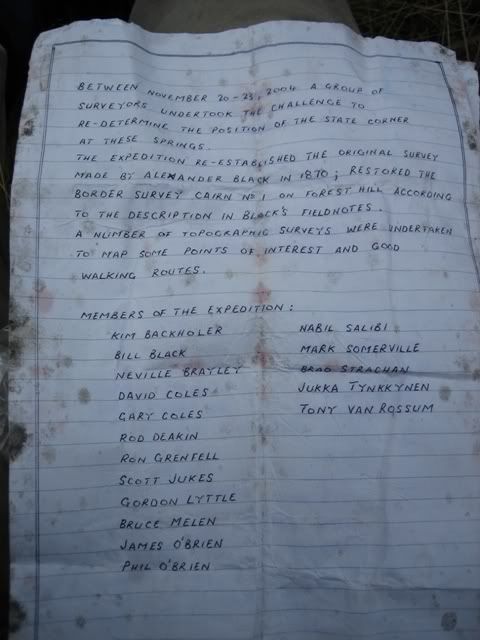
On two sides of the cairn are rows of rocks along the line of the border. We decided to follow the westward one on a bearing to see if we could find the source of the Murray. About 400 metres along that line there is a soak which feeds a small creek running westwards. There is a steel pole in the soak with a canister in which there is a small book. This does not look official.
Curiously, the map shows the end of the straight line to be not the source we found, but the junction of three creeks upstream of the creek fed by the soak.
As for access, there is a well-used track from the cairn in the general direction of the source. It carries on down to the gully which is the Murray, although there was no running water there. (This despite almost record rainfall over the last two weeks.)
We did not follow the track, wanting to get to the fire trail quickly, but we suspect it follows the Murray down to Cowambat Flat.
I wanted to clarify one thing because I did not really understand it from the info people provided.
Forest Hill is quite long. There are knolls at each end and a small saddle in the middle. The 1:50000 map shows a horizontal benchmark on the southern knoll. The straight line part of the border runs through the edge of the saddle. We did not actually go to the southern knoll to see what was there.
What we found was a cairn in the saddle which is described as the "number 1 station" for marking the border. It is not the source of the Murray. It is also fairly closed in by bush, and you have to consciously look above the bushes to see the pole sticking out of the top.
On two sides of the cairn are rows of rocks along the line of the border. We decided to follow the westward one on a bearing to see if we could find the source of the Murray. About 400 metres along that line there is a soak which feeds a small creek running westwards. There is a steel pole in the soak with a canister in which there is a small book. This does not look official.
Curiously, the map shows the end of the straight line to be not the source we found, but the junction of three creeks upstream of the creek fed by the soak.
As for access, there is a well-used track from the cairn in the general direction of the source. It carries on down to the gully which is the Murray, although there was no running water there. (This despite almost record rainfall over the last two weeks.)
We did not follow the track, wanting to get to the fire trail quickly, but we suspect it follows the Murray down to Cowambat Flat.
This post is copyright by davidmorr. Permission to reproduce elsewhere may be granted on application. Please PM me for details.
- davidmorr
- Athrotaxis cupressoides
- Posts: 448
- Joined: Tue 09 Feb, 2010 11:39 pm
- Location: Newcastle
- Region: New South Wales
- Gender: Male
Re: Source of the Murray
![]() by silicon » Thu 17 Apr, 2014 1:05 pm
by silicon » Thu 17 Apr, 2014 1:05 pm
You can see a few photos of the Forest Hill Cairn and the Murray Spring (defined start of the Murray River) here:
http://members.iinet.net.au/~mtmajor/AAWT2008page7.html
http://members.iinet.net.au/~mtmajor/AAWT2008page7.html
- silicon
- Nothofagus gunnii

- Posts: 14
- Joined: Tue 07 Jan, 2014 12:28 pm
- Region: New South Wales
- Gender: Male
Re: Source of the Murray
![]() by davidmorr » Thu 17 Apr, 2014 2:05 pm
by davidmorr » Thu 17 Apr, 2014 2:05 pm
The bush around the cairn has grown up a bit since then. Around two metres high now.
This post is copyright by davidmorr. Permission to reproduce elsewhere may be granted on application. Please PM me for details.
- davidmorr
- Athrotaxis cupressoides
- Posts: 448
- Joined: Tue 09 Feb, 2010 11:39 pm
- Location: Newcastle
- Region: New South Wales
- Gender: Male
Re: Source of the Murray
![]() by davidmorr » Sat 19 Jul, 2014 4:06 pm
by davidmorr » Sat 19 Jul, 2014 4:06 pm
This post is copyright by davidmorr. Permission to reproduce elsewhere may be granted on application. Please PM me for details.
- davidmorr
- Athrotaxis cupressoides
- Posts: 448
- Joined: Tue 09 Feb, 2010 11:39 pm
- Location: Newcastle
- Region: New South Wales
- Gender: Male
38 posts
• Page 1 of 2 • 1, 2
Return to New South Wales & ACT
Who is online
Users browsing this forum: No registered users and 21 guests