In a months time a mate and I are planning a walk in to the Valentines and Grey Mare huts area to base camp there and flyfish the small creeks for a couple of days.
I have been speaking to a fellow flyfisher and he suggested heading up from Guthega power station.By looking at maps of the area coming in from Round Mountain looks a good option as well.It looks a tough walk up from Geehi Dam and have pretty well ruled out going in from Tooma Dam past Pretty Plain Hut due to regrowth heading to Grey Mare which is mentioned on this forum elsewhere.
I am after any info please on routes regarding easiest,quickest,most scenic or any other valid reason to choose that route.
Also info on a good campsite along with appropriate reason would be appreciated please.
Hikes in to Valentines and Grey Mare Huts area(KNP)
Forum rules
NSW & ACT specific bushwalking discussion. Please avoid publishing details of access to sensitive areas with no tracks.
NSW & ACT specific bushwalking discussion. Please avoid publishing details of access to sensitive areas with no tracks.
35 posts
• Page 1 of 2 • 1, 2
Hikes in to Valentines and Grey Mare Huts area(KNP)
![]() by MeanderingFlyFisher » Fri 04 Dec, 2015 7:36 pm
by MeanderingFlyFisher » Fri 04 Dec, 2015 7:36 pm
- MeanderingFlyFisher
- Athrotaxis cupressoides

- Posts: 227
- Joined: Sun 02 Aug, 2015 7:21 pm
- Location: Warrnambool,Vic
- Region: Victoria
- Gender: Male
Re: Hikes in to Valentines and Grey Mare Huts area(KNP)
![]() by kjbeath » Fri 04 Dec, 2015 8:40 pm
by kjbeath » Fri 04 Dec, 2015 8:40 pm
Coming in from Round Mountain allows a circuit walk returning along Farm Ridge trail. This way the packs are lighter climbing out of the Tumut.
- kjbeath
- Athrotaxis cupressoides
- Posts: 174
- Joined: Tue 28 Sep, 2010 6:02 pm
- Region: New South Wales
- Gender: Male
Re: Hikes in to Valentines and Grey Mare Huts area(KNP)
![]() by Lophophaps » Fri 04 Dec, 2015 10:09 pm
by Lophophaps » Fri 04 Dec, 2015 10:09 pm
Forget about Tooma Dam and Geehi Dam to get to Grey Mare Hut. Tooma has much regrowth on many 4WD tracks - all but impassible. Yoo should be able to get to Pretty Plain Hut without much difficulty, but there may be a deep ford, maybe a metre. After PP Hut there are three sections of scrub. From the head of the hut valley east to 1640 metres, not too bad. Then there's an open plain for 800 metres to 169936, whence you may find a marked pad, or maybe not. The 4WD track is gone! Push through that to the other side and there's another band of scrub to 1640 metres, where the 4WD track starts again. This goes over the broad saddle and then vanishes. You may find the old Strumbo Fire Track, you may not. Once at 188917 head east over easy ground to GM Hut.
Geehi Dam involves a tedious drive to the dam and a horrible road bash. Never again! Coming from Corryong, if you go left just before Khancoban, you can be at Round Mountain before you go the other way and reach the Geehi Dam turnoff on the Alpine Way. Also, there are no parking fees at Round Mountain. Coming in from Guthega Power Station aka Munyang is possible, but there's a lot more driving and the walk is not that pleasant. There's also a climb to get out of Munyang.
The walk from Round Mountain to Grey Mare Hut is a longish day. Taking two days makes it much easier. The Round Mountain Fire Trail is very easy to follow, well graded. There's good campsites and relaible water at any number of places on the way. If taking two days, camp at or near SMC Hut, whatever it's called, 3 kilometres west of Jagungal, 216992. There are a handful of river crossings, all quite shallow. There's good camping at Grey Mare Hut, but I wonder if this is a little too far from the fish.
As suggested above, you can vary the walk out by taking Farm Ridge. There's flat ground on the Tumut River, and a kilometre downstream of the ford at 254099 there's a bit of shelter near the bluff. It's a moderate climb to Round Mountain Hut.
The ability to have a different and very nice alternative route out makes Round Mountain the one to use. If you can navigate off-track you can go up the Geehi or Valentine, and maybe bag Jagungal, which can be approached from many directions.
-

Lophophaps - Auctorita modica

- Posts: 3382
- Joined: Wed 09 Nov, 2011 9:45 am
- Region: Victoria
- Gender: Male
Re: Hikes in to Valentines and Grey Mare Huts area(KNP)
![]() by zac150 » Mon 07 Dec, 2015 11:50 am
by zac150 » Mon 07 Dec, 2015 11:50 am
The easiest walk into Valentines would be from Guthega power station; it is a comfortable days walk and can be varied by either taking the different aquaducts or by walking back via Mawsons or Tin Hut.
The following is coming from a non fisherman - Valentines would seem to be the less obvious choice as the rivers that run past or near valentines are up river of a very large waterfall. I have watched people fish the rivers there with little to no success i.e no bites and no signs of fish. I know Tooma dam is well stock with trout (you can see them raising) so any of the rivers that lead into Tooma would be well worth fishing and there are huts / camp sites all along the rivers which would offer good base camp options.
I can't speak for Greymare as I am not sure what is downhill from Valentines falls.
The other area which might be of interest is happy jacks plain, again there are great huts and plenty of small rivers that run into the dam (name escapes me).
- zac150
- Athrotaxis cupressoides
- Posts: 120
- Joined: Sun 02 May, 2010 4:57 pm
- Region: Australian Capital Territory
- Gender: Male
Re: Hikes in to Valentines and Grey Mare Huts area(KNP)
![]() by MeanderingFlyFisher » Mon 07 Dec, 2015 7:29 pm
by MeanderingFlyFisher » Mon 07 Dec, 2015 7:29 pm
Thanks for all the replies it is all definately helping me piece the puzzle together.
I shall try and explain how we fish on a typical day whether it be from car camping or a hike in tent base camp which I hope may help source the good oil from experienced hikers on this forum as I am fairly confident there are trout in most of the little creeks in the area.Although there are some exceptions which we have found in the KNP but that is all part of the exploring side of what we do.
First of all we find a little blue line(I call it bluelining)on the map which we consider has potential to have trout in it.Then we work out a way in and a way out at our approximate exit point.The day generally starts with a hike,bushbash,cliff scramble etc of somewhere between 1/2-2 hours.We fish all day(around 6 hours)upstream covering between 2-4KM and hopefully catching a trout or 2.Then we either walk downstream to where we started and retrace our steps back to camp or if there is a bushbash,rockscramble up to a track or ridge we do that and then hike back to camp.I am definately not a carry the esky to the river and sit on the bank all day type of fisherman.It could almost be called extreme fishing adventures and is a full on day.
Lophophaps please excuse my ignorance as I generally navigate by maps NSW 1:25000 using mainlylandmarks,compass and lat/long and I need more info on your grid reference system or should I start a separate topic on this or even find a tutorial on this.
- MeanderingFlyFisher
- Athrotaxis cupressoides
- Posts: 227
- Joined: Sun 02 Aug, 2015 7:21 pm
- Location: Warrnambool,Vic
- Region: Victoria
- Gender: Male
Re: Hikes in to Valentines and Grey Mare Huts area(KNP)
![]() by skibug » Mon 07 Dec, 2015 8:30 pm
by skibug » Mon 07 Dec, 2015 8:30 pm
Have never done it but you can come into Grey Mare hut from Olsen's Lookout, to the south, along Grey Mare fire trail. It's a biggish ascent, but possibly the shortest distance. It would give you great views of the Main Range, too.
Skibug
Skibug
- skibug
- Athrotaxis cupressoides
- Posts: 156
- Joined: Tue 13 Mar, 2012 7:13 pm
- Region: New South Wales
- Gender: Male
Re: Hikes in to Valentines and Grey Mare Huts area(KNP)
![]() by Lophophaps » Mon 07 Dec, 2015 9:09 pm
by Lophophaps » Mon 07 Dec, 2015 9:09 pm
MFF, that's a lovely description. Not my cup of tea but very relaxing.
Grid references are not hard to understand but it may take a while to become proficient. On the Khancoban 1:25 000 map find the round Mountain car park, at the top near the right. The numbers at the top show eastings in 1000 metre increments. There are other numbers to really nail the reference in Australia but if you say Khancoban 1:25 or know where the place is roughly the grid will suffice.
Just above Round Mountain are 22, 23, 24 etc. These numbers are eastings.The car park is on the bend between 23 and 24, so estimate tenths east and get 6. So the easting ref is 236. The car park is in the 11-12 grid (on the right edge) so esimate how far above the 11 line, 3. The ref here is thus 113. This is a northing. The system is across and then up, like in the Melways.
Bung them together and you get a grid reference 236113.
Round Mountain Hut is 244100. The Tumut River down the track is 254100. Mm, interesting. the hut and river are not on the line but I reckon both are close enough. The last of each three-figure group is often a toss-up, so have a descriptionas well if you can.
I suggest that you work through the grid references that I gave and see if they make sense. keep at it - the first 35 years are the hardest. As the map may be folded with the edges hidden, I write eastings and northings in the middle. Mostly it doesn't matter as I just navigate off the map and don't need a grid reference.
Skibug, I've gone in and out summer and winter via Grey Mare FT. It's a long way with upness and downness but can be walked in a day. I'm not sure if the FT is open; fires may have done damage. I know that just above GM Hut the FT is all but gone, so you may have to navigate. There's good views and nice camping.
-
Lophophaps - Auctorita modica
- Posts: 3382
- Joined: Wed 09 Nov, 2011 9:45 am
- Region: Victoria
- Gender: Male
Re: Hikes in to Valentines and Grey Mare Huts area(KNP)
![]() by Mark F » Mon 07 Dec, 2015 9:31 pm
by Mark F » Mon 07 Dec, 2015 9:31 pm
Lophophaps - Round Mountain is on the Toolong Range 1:25k lpi sheet. Round Mountain Hut is 245103. Are you working with an old AMG map?
Once you get used to grid references it is much easier to work out exactly where you are compared to lat long.
Once you get used to grid references it is much easier to work out exactly where you are compared to lat long.
"Perfection is attained not when there is nothing more to add, but when there is nothing more to remove".
-

Mark F - Lagarostrobos franklinii

- Posts: 2332
- Joined: Mon 19 Sep, 2011 8:14 pm
- Region: Australian Capital Territory
- Gender: Male
Re: Hikes in to Valentines and Grey Mare Huts area(KNP)
![]() by Lophophaps » Tue 08 Dec, 2015 4:39 am
by Lophophaps » Tue 08 Dec, 2015 4:39 am
Mark, I have the CMA Khacoban 1:50 000 first edition 1981. It looks like Round Mountain Hut has moved 2-300 metres north in 30 years. If camped at the hut one could have a very slow journey to the road. I don't like the 1:25s - too much paper to carry and too hard to get perspective. A scale of 1:50 is fine wth me, even if the information is out of date and the maps are falling apart. For example, my map shows the Strumbo Hill Fire Trail from near Pretty Plain Hut to near Grey Mare Hut, and the Strawberry Hill Fire Trail south of Jagungal. I've walked and skied on both.
Agree, grid references are much easier to use than lat and long.
I forgot to mention that a GPS is a backup to a paper map. Nothing replaces paper. Knowing (mainly) paper-based navigation techniques such as handrails, offset, back-bearing and the like really assists. Without mastering techniques such as these, if the GPS fails in thck fog then it will be quite interesting. For me at least, it's much more satisfying navigating this way.
-
Lophophaps - Auctorita modica
- Posts: 3382
- Joined: Wed 09 Nov, 2011 9:45 am
- Region: Victoria
- Gender: Male
Re: Hikes in to Valentines and Grey Mare Huts area(KNP)
![]() by Mark F » Tue 08 Dec, 2015 7:57 am
by Mark F » Tue 08 Dec, 2015 7:57 am
Lophophaps - The only reason I posted last night is that the op said he was using the NSW 1:25k topos. You are working with a AMG map not a MGA map based on GDA94 datum. MGA is the current projection which aligns with UTM and the GPS system. Between AGM and MGA grid references move about 200 metres NE.
I found a couple of old (1959) 1:50k maps in my map box last night (Bimberi and Yaouk) with 1,000 yard grids. You have to be careful
I found a couple of old (1959) 1:50k maps in my map box last night (Bimberi and Yaouk) with 1,000 yard grids. You have to be careful
"Perfection is attained not when there is nothing more to add, but when there is nothing more to remove".
-
Mark F - Lagarostrobos franklinii
- Posts: 2332
- Joined: Mon 19 Sep, 2011 8:14 pm
- Region: Australian Capital Territory
- Gender: Male
Re: Hikes in to Valentines and Grey Mare Huts area(KNP)
![]() by Lophophaps » Tue 08 Dec, 2015 8:16 am
by Lophophaps » Tue 08 Dec, 2015 8:16 am
Mark F wrote:Lophophaps - The only reason I posted last night is that the op said he was using the NSW 1:25k topos. You are working with a AMG map not a MGA map based on GDA94 datum. MGA is the current projection which aligns with UTM and the GPS system. Between AGM and MGA grid references move about 200 metres NE.
I found a couple of old (1959) 1:50k maps in my map box last night (Bimberi and Yaouk) with 1,000 yard grids. You have to be careful
Agreed. My understanding is that the new 1:25s have the same borders as the old 1:50s. I selected RM car park and nearby as they should be close to a corner of a 1:25, close to the eastings and northings, thus making it easier to see them. It seems that the top half of Kosciusko 1:100 is Khancoban 1:50, and the right half of that is Toolong Ranges 1:25. I was unaware that the grids had changed.
Chapman AAWT has Jagungal at 248987, sourced from LPI Jagungal 1:25. My 1981 CMA 1:50 Khancoban has Jagungal at 247986. Chapman has Mackays Hut at 318053, Khacoban 1:50 has 317050. This is instructive.
I still have some sticky tape left so I can put off buying a new map for a while. If the maps disintegrate before I do I'll buy.
-
Lophophaps - Auctorita modica
- Posts: 3382
- Joined: Wed 09 Nov, 2011 9:45 am
- Region: Victoria
- Gender: Male
Re: Hikes in to Valentines and Grey Mare Huts area(KNP)
![]() by MeanderingFlyFisher » Tue 08 Dec, 2015 7:25 pm
by MeanderingFlyFisher » Tue 08 Dec, 2015 7:25 pm
Wow Lophophaps I assume you didn't invent that grid system but how great and easy it is and thanks very much for explaining.
Just a thought but a few years back another flyfishing mate had all his maps covered in clear contact(the colored stuff doesn't work very well ) and since then I have always done the same to mine.Not sure if you have to draw on your maps but the contact holds them together and waterproofs them as well so you can get them out on the trail rain,hail or shine.
Just a thought but a few years back another flyfishing mate had all his maps covered in clear contact(the colored stuff doesn't work very well
- MeanderingFlyFisher
- Athrotaxis cupressoides
- Posts: 227
- Joined: Sun 02 Aug, 2015 7:21 pm
- Location: Warrnambool,Vic
- Region: Victoria
- Gender: Male
Re: Hikes in to Valentines and Grey Mare Huts area(KNP)
![]() by climberman » Tue 08 Dec, 2015 9:13 pm
by climberman » Tue 08 Dec, 2015 9:13 pm
MeanderingFlyFisher wrote:Wow Lophophaps I assume you didn't invent that grid system but how great and easy it is and thanks very much for explaining.
Just a thought but a few years back another flyfishing mate had all his maps covered in clear contact(the colored stuff doesn't work very well
MFF, are you dead set on Grey Mare and Valentine? For a first foray into the area I'd fish the Tooma River upstream of the Tooma Dam, accessing via the Dargals and Wheelers Hut tracks. Wheelers is a lovely hut to stay at or near for fishing. Above Pretty Plain (GR 165995 on the Jagungal 1:25K) you could head up Pretty Plain Creek, Bulls Head Peak or the (very) upper Tooma. Above Pretty Plain is getting to be proper alpine twig water. Pretty Plain Hut is on Bulls Head Creek. All nicer walking than the trudge up from Munyang power station towards Valentine I reckon.
Another suggestion might be the Burrungubugge River or Gungarlin Rivers, to the east of the above area (about 10-12km east as the crow flies), accessible from either the Nimmo Road (off the Eucumbene Road) or the Snowy Adit below Island Bend, with parking at the Snowy River.
I spent a lovely Easter on year fishing the Gungarlin from Nimmo Rd down through Botherum Plain, the Gorge and to the Aqueduct intake and then returning via the Burrungubugge R and over the Brassy Gap near Kidmans (sort of).
Stimmies, Bredbo's, Wee Creek Hoppers, Stick Caddis (esp on the flowing sections of the Tooma), nymphs.
Have fun let us know what you do
- climberman
- Phyllocladus aspleniifolius

- Posts: 656
- Joined: Tue 09 Dec, 2008 7:32 pm
Re: Hikes in to Valentines and Grey Mare Huts area(KNP)
![]() by Lophophaps » Tue 08 Dec, 2015 9:31 pm
by Lophophaps » Tue 08 Dec, 2015 9:31 pm
I did not invent the grid. If I had I would have left in place, complete with 1:50,000 maps, and no regrowth.
I had a few maps laminated but gave it up. The cost of the laminating is quite high compared to the cost of new maps. The laminated maps are mongrels to fold and keep in a small placcy bag. Laminated maps leak at the fold joins. As you have observed I'm using maps that are over 30 years old. Khancoban 1:50 should be replaced, but I don't see the need. I also can't see a laminated map lasting that long. The Khancoban map has probablys een 2-300 days in KNP, summer and winter.
The place for laminated maps is in a map tube, the home or the office. The maps do not get folded and will last forever. I have a laminated Tim Lamble Jagungal map from 1978, good as new. My laminated Budawangs map is still pristine maybe 35 years on.
My system is simple. Fold the maps away from the folds that the maps come from so that you can see where you are going; the initial folds do not necessarily do this. By folding in a different place each time the map wears out more or less uniformly. I fold to about A4 size, in two plastic bags, one opening up, the other down. In bad weather the map goes into the parka. I cannot recall any water getting in. Often I have the map in the pack as I don't need it for a compass bearing or following a feature.
Climberman, distinct possibilities all. Biggish water from Tooma Res. to Pretty Plain. At Pretty Plain Hut the creek is probably too small to fish. Nice hut.
-
Lophophaps - Auctorita modica
- Posts: 3382
- Joined: Wed 09 Nov, 2011 9:45 am
- Region: Victoria
- Gender: Male
Re: Hikes in to Valentines and Grey Mare Huts area(KNP)
![]() by MeanderingFlyFisher » Wed 09 Dec, 2015 6:51 pm
by MeanderingFlyFisher » Wed 09 Dec, 2015 6:51 pm
Climberman,thanks for your suggestions Tooma and Pretty Plain(also other suggestions).I have fished a fair bit in the Snowy twig waters within an hour or 2 walk of the roads and did a 3 day hike/fishing trip above Dead Horse Gap in April this year and picked Grey Mare and Valentines area partly because there looks to be plenty of options in the area,an article on the area in Flylife,a recommendation from a fly fishing mate who has fished there and also neither my flyfishing mate or I have been there.I am always open to suggestions and Pretty Plain is on my hit list but didn't consider this as my companion on this trip has done the Tooma numerous times and did Pretty Plain earlier this year as well.If he is perusing this topic he is most welcome to join in the discussion.
Lophophaps,thanks for your thoughts on map use and care.Always interesting to hear what other people do and you input in to this topic has been sensational.It looks like you might be in the midst of a discussion between a couple of "Twig Water Addicts"(Definition-Flyfishermen who seek to catch trout out of the smallest water possible and I have even caught trout from a "Twig Water" casting with one leg on either bank straddling the creek)So your comment on Pretty Plain Creek although very well intentioned may be a little inaccurate to a twig water addict because it may be just the type of water I am looking for.
Lophophaps,thanks for your thoughts on map use and care.Always interesting to hear what other people do and you input in to this topic has been sensational.It looks like you might be in the midst of a discussion between a couple of "Twig Water Addicts"(Definition-Flyfishermen who seek to catch trout out of the smallest water possible and I have even caught trout from a "Twig Water" casting with one leg on either bank straddling the creek)So your comment on Pretty Plain Creek although very well intentioned may be a little inaccurate to a twig water addict because it may be just the type of water I am looking for.
- MeanderingFlyFisher
- Athrotaxis cupressoides
- Posts: 227
- Joined: Sun 02 Aug, 2015 7:21 pm
- Location: Warrnambool,Vic
- Region: Victoria
- Gender: Male
Re: Hikes in to Valentines and Grey Mare Huts area(KNP)
![]() by climberman » Thu 10 Dec, 2015 3:58 am
by climberman » Thu 10 Dec, 2015 3:58 am
MFF - Great! Enjoy, do let us know what you end up doing. Is that DA's recent Flylife article? I've not got that far through yet.
- climberman
- Phyllocladus aspleniifolius
- Posts: 656
- Joined: Tue 09 Dec, 2008 7:32 pm
Re: Hikes in to Valentines and Grey Mare Huts area(KNP)
![]() by MeanderingFlyFisher » Thu 10 Dec, 2015 4:59 am
by MeanderingFlyFisher » Thu 10 Dec, 2015 4:59 am
Climberman,DA's article is on Leatherbarrel.I'm talking about Toc's article on "Geehi and Jagungal" a couple of years back(not sure which issue)Mountain men in FL#19 is one of my favorite articles.
- MeanderingFlyFisher
- Athrotaxis cupressoides
- Posts: 227
- Joined: Sun 02 Aug, 2015 7:21 pm
- Location: Warrnambool,Vic
- Region: Victoria
- Gender: Male
Re: Hikes in to Valentines and Grey Mare Huts area(KNP)
![]() by climberman » Thu 10 Dec, 2015 7:22 am
by climberman » Thu 10 Dec, 2015 7:22 am
MeanderingFlyFisher wrote:Climberman,DA's article is on Leatherbarrel.I'm talking about Toc's article on "Geehi and Jagungal" a couple of years back(not sure which issue)Mountain men in FL#19 is one of my favorite articles.
Ahh, will crack open the back issues and have a gander. Am thinking of an MTB into Happy Jacks over the New Year period for a few days' solo fishing.
- climberman
- Phyllocladus aspleniifolius
- Posts: 656
- Joined: Tue 09 Dec, 2008 7:32 pm
Hikes in to Valentines and Grey Mare Huts area(KNP)
![]() by warnesy » Thu 10 Dec, 2015 11:35 am
by warnesy » Thu 10 Dec, 2015 11:35 am
Good topic, I have been following.
Lophophaps that creek outside pretty plains is exactly the type of water MFF and I chase on these trips. We would even fish water smaller than that. I've spent a lot of time in the Tooma area so keen to explore somewhere else. Still haven't had a chance yet to study the maps of the suggestions on this thread but hope to do so on the weekend.
I am currently more focussed on lightening my load as fishing gear adds a bit of weight. Most walks I am around 26-28kgs...
- warnesy
- Athrotaxis cupressoides
- Posts: 122
- Joined: Sat 04 Apr, 2015 12:57 pm
- Region: Australian Capital Territory
Re: Hikes in to Valentines and Grey Mare Huts area(KNP)
![]() by Lophophaps » Thu 10 Dec, 2015 12:55 pm
by Lophophaps » Thu 10 Dec, 2015 12:55 pm
Nice places to visit indeed.
-
Lophophaps - Auctorita modica
- Posts: 3382
- Joined: Wed 09 Nov, 2011 9:45 am
- Region: Victoria
- Gender: Male
Re: Hikes in to Valentines and Grey Mare Huts area(KNP)
![]() by Tony » Thu 10 Dec, 2015 2:11 pm
by Tony » Thu 10 Dec, 2015 2:11 pm
Hi MFF,
There is a chance that I might see you at Grey Mare Hut as I am currently planning a bike packing fly fishing trip into that area about the same time as you will be there.
I did some fly fishing out of Grey Mare Hut in 2009, on that trip we cycled in from Round Mountain carpark, prior to 2009 I have walked into Grey Mare Hut from from Wheeler Hut via Strumbo Range and via Valentines Hut. As previously suggested earlier in this thread Grey Mare Hut is a long walk from any trail head and I have been told that the Strumbo Range is very difficult walking these days.
The fishing was OK back then, we caught fish in Back Flat Creek, Valentines and upper Geehi, my mate Dave F. hooked a nice Rainbow in the Geehi just below where the Valentines enters the Geehi but he lost it when he tried to land it, if you can check out FL 57 Back Country Lite article, there is a great photo of me having a cuppa around the outside camp fire at Grey Mare Hut, one of my favourite camp sites. Back in 2009 we tried to fish the Geehi below the junction of Valentines but the scrub was very hard to get through and the Geehi had a good flow that made walking in the river impossible. The Valentines from Geehi to the base of the Valentines Falls was easy fishing, the upper Geehi was a bit more difficult but OK in places. On that trip I had not cycled for 15 years, I did that trip cold turkey and suffered very badly, on the up-coming trip it will be a different story as I am much fitter on the bike and have a far better MTB and touring gear.
In the last few years we have found the fishing in the KNP high country hard going, with often no fish seen or caught on some trips, and even at some of our favourite most reliable spots only getting a few fish between us.
Tony
There is no such thing as bad weather.....only bad clothing. Norwegian Proverb
-
Tony - Athrotaxis selaginoides

- Posts: 1896
- Joined: Fri 16 May, 2008 1:40 pm
- Location: Canberra
- Region: Australian Capital Territory
Re: Hikes in to Valentines and Grey Mare Huts area(KNP)
![]() by johnrs » Thu 10 Dec, 2015 4:20 pm
by johnrs » Thu 10 Dec, 2015 4:20 pm
MFF
Lots of fish in the Geehi above the dam
but it is a long climb.
Possibly better over two days
And I think the road has been closed some way back below the dam
John
Lots of fish in the Geehi above the dam
but it is a long climb.
Possibly better over two days
And I think the road has been closed some way back below the dam
John
- johnrs
- Phyllocladus aspleniifolius
- Posts: 621
- Joined: Mon 09 Aug, 2010 6:09 pm
- Region: New South Wales
Re: Hikes in to Valentines and Grey Mare Huts area(KNP)
![]() by MeanderingFlyFisher » Thu 10 Dec, 2015 7:34 pm
by MeanderingFlyFisher » Thu 10 Dec, 2015 7:34 pm
Climberman,"Geehi and Jagungal" is in FL 74 and Happy Jacks also sounds interesting,hope you enjoy.
Warnsey,glad to see you have come aboard this topic as you know sometimes my navigational skills can go astray
Tony,that is a great photo and feel free to share a cappacino with us if we bump in to you.Dave F's articles are also helpful and thanks for your input.
John,We have done a day trip a few KM up from Geehi Dam getting some nice fish and Warnsey losing a ripper(sorry Warnsey)21 months back be basically parked at the dam wall and walked up the track crossing the bridge above the dam and going anothe 2KM up the track before dropping down the steep bank to the river.
- MeanderingFlyFisher
- Athrotaxis cupressoides
- Posts: 227
- Joined: Sun 02 Aug, 2015 7:21 pm
- Location: Warrnambool,Vic
- Region: Victoria
- Gender: Male
Re: Hikes in to Valentines and Grey Mare Huts area(KNP)
![]() by RVG » Fri 11 Dec, 2015 1:48 pm
by RVG » Fri 11 Dec, 2015 1:48 pm
MF
The Burrungubuggee holds a good number of trout and is readily accessed from Island Bend. There is an old vehicle track beside it as far as the old Constances Hut site and a foot track for a short distance above there.
Further upstream near Kidmans Hut a good number of small trout can be seen. I've caught little ones in the Burrungubuggee quite close to the Hut (and there is a frying pan in the hut for just such occasions). Near Kidmans, Dead Horse Creek is a major tributary of the Burrungubuggee and it looks like it should hold trout but I doubt whether it's been fished in living memory.
- RVG
- Atherosperma moschatum

- Posts: 81
- Joined: Sat 02 May, 2015 2:18 pm
- Region: New South Wales
Re: Hikes in to Valentines and Grey Mare Huts area(KNP)
![]() by climberman » Fri 11 Dec, 2015 7:14 pm
by climberman » Fri 11 Dec, 2015 7:14 pm
MFF - the road has been closed recently AFAIK so that you can't drive to the Geehi Dam. I'd call NPWS Jindy to check, it's not on their list but worth checking.
- climberman
- Phyllocladus aspleniifolius
- Posts: 656
- Joined: Tue 09 Dec, 2008 7:32 pm
Re: Hikes in to Valentines and Grey Mare Huts area(KNP)
![]() by MeanderingFlyFisher » Sat 12 Dec, 2015 6:20 pm
by MeanderingFlyFisher » Sat 12 Dec, 2015 6:20 pm
Climberman,I had pretty well ruled out walking up from the Geehi Dam but thanks for the heads up.
- MeanderingFlyFisher
- Athrotaxis cupressoides
- Posts: 227
- Joined: Sun 02 Aug, 2015 7:21 pm
- Location: Warrnambool,Vic
- Region: Victoria
- Gender: Male
Re: Hikes in to Valentines and Grey Mare Huts area(KNP)
![]() by MeanderingFlyFisher » Sun 13 Dec, 2015 6:44 pm
by MeanderingFlyFisher » Sun 13 Dec, 2015 6:44 pm
After much discussion with Warnsey I have an announcement.
The winner is ..
zac150
We have decided to head up from Munyang power station to Valentines and possibly do Grey Mare and beyond from there depending on where our fly rods point us.
I sincerely thank all who have contributed to this topic and have taken note of all the suggestions for future trips.
The winner is ..
zac150
We have decided to head up from Munyang power station to Valentines and possibly do Grey Mare and beyond from there depending on where our fly rods point us.
I sincerely thank all who have contributed to this topic and have taken note of all the suggestions for future trips.
- MeanderingFlyFisher
- Athrotaxis cupressoides
- Posts: 227
- Joined: Sun 02 Aug, 2015 7:21 pm
- Location: Warrnambool,Vic
- Region: Victoria
- Gender: Male
Re: Hikes in to Valentines and Grey Mare Huts area(KNP)
![]() by Tony » Mon 14 Dec, 2015 3:05 pm
by Tony » Mon 14 Dec, 2015 3:05 pm
Hi MFF,
A good choice, I love the area but I spent most of my time up around there snowshoeing in winter now days.
My mate Dave has caught a few small Rainbows up above the Valentines Falls, that was a few years ago now but not sure how it will fish now, there used to be a foot track down the side of Valentines falls which would save a lot of time to Grey Mare Hut but I do not think it is there now after the 2003 fires, a few years after the fires Dave and I did go from Grey Mare Hut to Valentines via the Falls Track, there was no foot track then, we made it but it was very hard going with lots of scrub bashing and probably much worse now.
The best place to get water at Grey Mare Hut is follow the track up behind the Hut through the old mine tailing's and old mining equipment, there is a small creek with good water.
Hope to see you up there, we will be 2 old blokes on Mountain bikes, I might do a side trip to Valentines Hut if I have the time as I have not been there for a while, though there are some very big hill to ride up.
I am thinking about keeping the fishing simple and using my Tenkara for this trip.
Tony
MeanderingFlyFisher wrote:After much discussion with Warnsey I have an announcement.
The winner is ..
zac150
We have decided to head up from Munyang power station to Valentines and possibly do Grey Mare and beyond from there depending on where our fly rods point us.
I sincerely thank all who have contributed to this topic and have taken note of all the suggestions for future trips.
A good choice, I love the area but I spent most of my time up around there snowshoeing in winter now days.
My mate Dave has caught a few small Rainbows up above the Valentines Falls, that was a few years ago now but not sure how it will fish now, there used to be a foot track down the side of Valentines falls which would save a lot of time to Grey Mare Hut but I do not think it is there now after the 2003 fires, a few years after the fires Dave and I did go from Grey Mare Hut to Valentines via the Falls Track, there was no foot track then, we made it but it was very hard going with lots of scrub bashing and probably much worse now.
The best place to get water at Grey Mare Hut is follow the track up behind the Hut through the old mine tailing's and old mining equipment, there is a small creek with good water.
Hope to see you up there, we will be 2 old blokes on Mountain bikes, I might do a side trip to Valentines Hut if I have the time as I have not been there for a while, though there are some very big hill to ride up.
I am thinking about keeping the fishing simple and using my Tenkara for this trip.
Tony
There is no such thing as bad weather.....only bad clothing. Norwegian Proverb
-
Tony - Athrotaxis selaginoides
- Posts: 1896
- Joined: Fri 16 May, 2008 1:40 pm
- Location: Canberra
- Region: Australian Capital Territory
Re: Hikes in to Valentines and Grey Mare Huts area(KNP)
![]() by MeanderingFlyFisher » Mon 14 Dec, 2015 7:27 pm
by MeanderingFlyFisher » Mon 14 Dec, 2015 7:27 pm
Mmm Tenkara would be an interesting and fascinating way to fish them waters.
If we do cross paths we will be the one young strapping guy with an old codger with a bright green day pack trying to keep up And of course we will be wearing camouflage biege,brown and olive apparel so you might not see us
If we do cross paths we will be the one young strapping guy with an old codger with a bright green day pack trying to keep up
- MeanderingFlyFisher
- Athrotaxis cupressoides
- Posts: 227
- Joined: Sun 02 Aug, 2015 7:21 pm
- Location: Warrnambool,Vic
- Region: Victoria
- Gender: Male
Re: Hikes in to Valentines and Grey Mare Huts area(KNP)
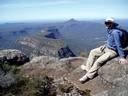
![]() by MeanderingFlyFisher » Tue 05 Jan, 2016 7:41 pm
by MeanderingFlyFisher » Tue 05 Jan, 2016 7:41 pm
Alas our trip is over  but what a fantastic trip it was
  I have spent the last few days recovering.
The walk in to Valentines was a tough uphill slog with heavy packs but was worth it to base camp and fish the area for a few days.We were in to fish almost immediately after setting up camp and a bit of a rest.
Then over the next couple of days we searched out several "blue lines" within a few KM's of the hut with limited success but did manage to see Grey Mare Hut and Mawsons Hut as well as some spectacular scenery involving some track and cross country hiking.
We moved camp to one of the feeder streams nearby and had some sensational technical fishing in the clearest water I have ever seen.The fish weren't easy but that made it into a very special day with every capture being hard earned.
The next day we fished a different part of the feeder stream which was much more bouldery than up further even discovering "First shower in 6 days Falls " which was just as sensational as the previous days fishing.
The most memorable fish of the trip was Warnsey' last fish which was a nice little brown that he caught out of a pool just above where he was standing and when he released it the trout couldn't swim back up to his home pool because it was too shallow and just sulked like a scolded dog until he was placed back in his home.
Then it was a quick trip to Schlinks Hut to make the next days hike out a bit shorter.
Spent a wonderful New Years Eve stargazing on a big granite rock which had been warmed by the sun all day.
For an area that is supposed to be busy at that time of the year we only saw about a dozen other people for the whole trip and it was most enjoyable sharing a yarn or 2 with them around a fire or on a rock somewhere.
I don't know if I could ever do a trip like this without flyfishing for trout but I do now understand why people do just hike.
I thank all the fellow forumites who contributed in my research for this trip.
Here's a few happy snaps which I hope you enjoy even a little bit as much as I did taking them.
Dinner on the first night was sensational and envied by others in the hut
We did manage to catch the odd trout
The walk in to Valentines was a tough uphill slog with heavy packs but was worth it to base camp and fish the area for a few days.We were in to fish almost immediately after setting up camp and a bit of a rest.
Then over the next couple of days we searched out several "blue lines" within a few KM's of the hut with limited success but did manage to see Grey Mare Hut and Mawsons Hut as well as some spectacular scenery involving some track and cross country hiking.
We moved camp to one of the feeder streams nearby and had some sensational technical fishing in the clearest water I have ever seen.The fish weren't easy but that made it into a very special day with every capture being hard earned.
The next day we fished a different part of the feeder stream which was much more bouldery than up further even discovering "First shower in 6 days Falls
The most memorable fish of the trip was Warnsey' last fish which was a nice little brown that he caught out of a pool just above where he was standing and when he released it the trout couldn't swim back up to his home pool because it was too shallow and just sulked like a scolded dog until he was placed back in his home.
Then it was a quick trip to Schlinks Hut to make the next days hike out a bit shorter.
Spent a wonderful New Years Eve stargazing on a big granite rock which had been warmed by the sun all day.
For an area that is supposed to be busy at that time of the year we only saw about a dozen other people for the whole trip and it was most enjoyable sharing a yarn or 2 with them around a fire or on a rock somewhere.
I don't know if I could ever do a trip like this without flyfishing for trout but I do now understand why people do just hike.
I thank all the fellow forumites who contributed in my research for this trip.
Here's a few happy snaps which I hope you enjoy even a little bit as much as I did taking them.
Dinner on the first night was sensational and envied by others in the hut
We did manage to catch the odd trout
- MeanderingFlyFisher
- Athrotaxis cupressoides
- Posts: 227
- Joined: Sun 02 Aug, 2015 7:21 pm
- Location: Warrnambool,Vic
- Region: Victoria
- Gender: Male
35 posts
• Page 1 of 2 • 1, 2
Return to New South Wales & ACT
Who is online
Users browsing this forum: Facebook [bot] and 47 guests