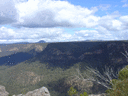
I was down on the Nattai river over the weekend and boy oh boy did it take buffering from the stormy weather of late.
Giant eroded cliff walls, most of veg is flattened probably 100 meters either side of where the banks used to be, and sandy beaches everywhere. Some parts are totally unrecognisable like the Wanganderry junction and the Allum flat ford. The ford now, which was the sleepiest more sedate crossing of the valley is now a two part crossing about 50 mtrs wide looking like the Vinyard flat crossing.
It was a hard old slog bashing up stream against the the pushed over, relentless tree fall but my most concerning moment was stepping waist deep into quick sand (or whatever the Aussie equivalent is) and as you could imagine the pigs are having a field day in the freshly turned, soft soil.
The new look Nattai.
Forum rules
NSW & ACT specific bushwalking discussion. Please avoid publishing details of access to sensitive areas with no tracks.
NSW & ACT specific bushwalking discussion. Please avoid publishing details of access to sensitive areas with no tracks.
21 posts
• Page 1 of 1
The new look Nattai.
![]() by puredingo » Mon 27 Jun, 2016 8:42 am
by puredingo » Mon 27 Jun, 2016 8:42 am
- puredingo
- Athrotaxis selaginoides

- Posts: 1267
- Joined: Mon 13 Feb, 2012 6:54 am
- Region: New South Wales
Re: The new look Nattai.
![]() by clarence » Mon 27 Jun, 2016 8:30 pm
by clarence » Mon 27 Jun, 2016 8:30 pm
I was up Ettrema and Jones Creek a few days back and it is a similar story (thankfully no pigs).
I will post a few photos of the force of the water through there.
Great trip too.
Clarence
I will post a few photos of the force of the water through there.
Great trip too.
Clarence
- clarence
- Athrotaxis cupressoides

- Posts: 327
- Joined: Sun 12 Feb, 2012 7:52 pm
- Region: Tasmania
- Gender: Male
Re: The new look Nattai.
![]() by michael_p » Tue 28 Jun, 2016 10:52 am
by michael_p » Tue 28 Jun, 2016 10:52 am
Photo from my trip down Martins Ck a few weeks back. The creek at this point is wide and flat and nearly everything was pushed over. Looking at the height of the flood debris the water must have been up near the 1m mark.
One foot in front of the other.
-
michael_p - Athrotaxis selaginoides
- Posts: 1377
- Joined: Sun 15 Nov, 2009 6:58 pm
- Location: Macarthur Region of Sydney.
- Region: New South Wales
- Gender: Male
Re: The new look Nattai.
![]() by Hughmac » Tue 28 Jun, 2016 7:01 pm
by Hughmac » Tue 28 Jun, 2016 7:01 pm
Probably re-jigged much of the track (such as it was) to Mittagong. Be a lot easier walking downstream than up for a while.
- Hughmac
- Athrotaxis cupressoides
- Posts: 154
- Joined: Sat 14 Apr, 2012 9:20 pm
- Region: New South Wales
Re: The new look Nattai.
![]() by puredingo » Tue 28 Jun, 2016 8:27 pm
by puredingo » Tue 28 Jun, 2016 8:27 pm
I just tried to post a photo from Sunday but it told me my file was too big?...first time I've ever been accused of that!!!
- puredingo
- Athrotaxis selaginoides
- Posts: 1267
- Joined: Mon 13 Feb, 2012 6:54 am
- Region: New South Wales
Re: The new look Nattai.
![]() by north-north-west » Wed 29 Jun, 2016 4:11 pm
by north-north-west » Wed 29 Jun, 2016 4:11 pm
puredingo wrote:I just tried to post a photo from Sunday but it told me my file was too big?...first time I've ever been accused of that!!!
You probably need to resize the image. Photo Comps have a size limit of 5MB, while for most of the rest of the forum the limit is 3MB.
"Mit der Dummheit kämpfen Götter selbst vergebens."
-

north-north-west - Lagarostrobos franklinii

- Posts: 15113
- Joined: Thu 14 May, 2009 7:36 pm
- Location: The Asylum
- ASSOCIATED ORGANISATIONS: Social Misfits Anonymous
- Region: Tasmania
Re: The new look Nattai.
![]() by kanangra » Wed 29 Jun, 2016 5:42 pm
by kanangra » Wed 29 Jun, 2016 5:42 pm
How did you get on going down Martin's Ck? Where did you drop in?
K
K
- kanangra
- Athrotaxis selaginoides
- Posts: 1335
- Joined: Sun 25 May, 2008 3:52 pm
Re: The new look Nattai.
![]() by michael_p » Wed 29 Jun, 2016 7:56 pm
by michael_p » Wed 29 Jun, 2016 7:56 pm
kanangra wrote:How did you get on going down Martin's Ck? Where did you drop in?
K
From Nattai Rd it is surprisingly easy. See this thread for some tidbits: viewtopic.php?f=5&t=23451.
Michael.
One foot in front of the other.
-
michael_p - Athrotaxis selaginoides
- Posts: 1377
- Joined: Sun 15 Nov, 2009 6:58 pm
- Location: Macarthur Region of Sydney.
- Region: New South Wales
- Gender: Male
Re: The new look Nattai.
![]() by kanangra » Thu 30 Jun, 2016 6:26 pm
by kanangra » Thu 30 Jun, 2016 6:26 pm
That's well upstream of the canyon. Could someone give me the GR for where that hew track cuts the Long Nose Rd.
K
K
- kanangra
- Athrotaxis selaginoides
- Posts: 1335
- Joined: Sun 25 May, 2008 3:52 pm
Re: The new look Nattai.
![]() by LachlanB » Fri 01 Jul, 2016 1:06 pm
by LachlanB » Fri 01 Jul, 2016 1:06 pm
I was down on the upper Nattai around Mittagong earlier in June. It's a bit of a mess too, the track's still there, but covered with debris and uprooted trees. Was quite slow going, especially upstream.
- LachlanB
- Athrotaxis cupressoides
- Posts: 381
- Joined: Mon 21 Apr, 2014 5:07 pm
- Region: New South Wales
- Gender: Male
Re: The new look Nattai.
![]() by michael_p » Fri 01 Jul, 2016 3:29 pm
by michael_p » Fri 01 Jul, 2016 3:29 pm
kanangra wrote:Could someone give me the GR for where that hew track cuts the Long Nose Rd.
Sorry I can't help you there. Mr Dingo may be able to give you an idea of where it comes out on Long Nose Rd.
Are you thinking of using the new trail to drop into Martins Ck from Long Nose Rd then head down stream.
You are probably well aware of this but I just thought I would mention it, the scrub along the creek is really thick.
Michael.
One foot in front of the other.
-
michael_p - Athrotaxis selaginoides
- Posts: 1377
- Joined: Sun 15 Nov, 2009 6:58 pm
- Location: Macarthur Region of Sydney.
- Region: New South Wales
- Gender: Male
Re: The new look Nattai.
![]() by puredingo » Fri 01 Jul, 2016 6:50 pm
by puredingo » Fri 01 Jul, 2016 6:50 pm
I'm away from my maps at the moment but I'll get on to it when I home, k.
Yeah Lachlan a mess is right...or is it a clean out? On the plus side all those swampy, stinky wallows where the pigs have rooted up the river banks have been flushed away. The negative side is it got flushed directly into our drinking water.
The Nattai water has never looked or smelled very appetising to drink but now as it flows over the fresh river sand and newly washed stones it looked a treat.
- puredingo
- Athrotaxis selaginoides
- Posts: 1267
- Joined: Mon 13 Feb, 2012 6:54 am
- Region: New South Wales
Re: The new look Nattai.
![]() by puredingo » Mon 04 Jul, 2016 11:14 am
by puredingo » Mon 04 Jul, 2016 11:14 am
K, the GR for the new track up to long nose Rd is roughly 621056 on my Hilltop 2nd ed topo.....I think?
- puredingo
- Athrotaxis selaginoides
- Posts: 1267
- Joined: Mon 13 Feb, 2012 6:54 am
- Region: New South Wales
Re: The new look Nattai.
![]() by gandolph » Thu 14 Jul, 2016 3:35 pm
by gandolph » Thu 14 Jul, 2016 3:35 pm
Could you please clarify this "new track". Are you talking about a constructed track or a taped route.
Does it cross the catchment of Martins Creek and provide a link between Nattai Road and Long Point Road?
And if so, were does it leave Nattai Road and were does it leave Long Point Road?
I am familiar with the "horse track", constructed by the Wattle Ridge owners, heading north into Martins Creek which starts 100metres in to the west of the car park.
-

gandolph - Nothofagus gunnii

- Posts: 14
- Joined: Fri 08 Feb, 2013 2:25 pm
- Region: New South Wales
- Gender: Male
Re: The new look Nattai.
![]() by michael_p » Thu 14 Jul, 2016 8:02 pm
by michael_p » Thu 14 Jul, 2016 8:02 pm
gandolph wrote:Could you please clarify this "new track". Are you talking about a constructed track or a taped route.
Does it cross the catchment of Martins Creek and provide a link between Nattai Road and Long Point Road?
And if so, were does it leave Nattai Road and were does it leave Long Point Road?
I am familiar with the "horse track", constructed by the Wattle Ridge owners, heading north into Martins Creek which starts 100metres in to the west of the car park.
Hi Gandolph,
NPWS have been doing a lot of hazard reduction burns down along Martins Ck. They have pushed an access track from Nattai Rd to Long Nose Ridge Rd. Not sure where on Nattai Rd it starts but I think it is well past the Starlights turn-off and before the Troys Ck trail turn-off. The new NPWS trail runs east from Nattai Rd and crosses Martins Ck at: -34.262517,150.412717. The section I walked along was vehicle wide. Puredingo has posted above a GR for where it comes out on Long Nose.
Unfortunately we have been discussing this area across more than one thread. There is some additional information in this thread: viewtopic.php?f=5&t=23451.
NPWS have also cleared and put out a ton of flag tape along the old fire trail down along Martins Ck that is referred to as the Disappointment Trail by Sloss. The "Horse Track" meets the Disappointment Trail after it drops into the valley.
Cheers,
Michael.
Edit: Edited for clarity.
One foot in front of the other.
-
michael_p - Athrotaxis selaginoides
- Posts: 1377
- Joined: Sun 15 Nov, 2009 6:58 pm
- Location: Macarthur Region of Sydney.
- Region: New South Wales
- Gender: Male
Re: The new look Nattai.
![]() by michael_p » Fri 15 Jul, 2016 5:39 pm
by michael_p » Fri 15 Jul, 2016 5:39 pm
Had some spare time this afternoon so I drew a schematic of the area. Hope this helps with working out where the new trail is.
- uppermartinsckschematic.png (45.69 KiB) Viewed 17272 times
One foot in front of the other.
-
michael_p - Athrotaxis selaginoides
- Posts: 1377
- Joined: Sun 15 Nov, 2009 6:58 pm
- Location: Macarthur Region of Sydney.
- Region: New South Wales
- Gender: Male
Re: The new look Nattai.
![]() by puredingo » Fri 15 Jul, 2016 5:55 pm
by puredingo » Fri 15 Jul, 2016 5:55 pm
Yeah, the new NPWS track starts off from a Nattai Rd fork at approximately 605041 on the Hill Top 2nd ed sheet. About a k before the Troys track and obviously on the opposite side of the road.
- puredingo
- Athrotaxis selaginoides
- Posts: 1267
- Joined: Mon 13 Feb, 2012 6:54 am
- Region: New South Wales
Re: The new look Nattai.
![]() by gandolph » Sat 16 Jul, 2016 2:56 pm
by gandolph » Sat 16 Jul, 2016 2:56 pm
Many thanks for all that info.
My son says he remembers seeing the start along Nattai Road early last year. I am interested to see how they pushed a road up through the cliff line along Long Nose Ridge road.
My so called "Horse Track" was constructed so that horse riders from Wattle Ridge could do a loop ride from the property down to Martins Creek and back up along the old logging road ( Sloss's Disappointment Trail)
Wattle Ridge owners also built the track out to Ahearns for horse use. They used a blade in front of a tractor. They also left picnic gear at the lookout for the punters. They did not seemed too concerned that it was against the rules in a wilderness zone. It was real scrub bash in the early days before the plaque went in. I carted abseiling gear out to the point once upon a time and went down the face for a direct decent into the valley.
Keep walking
John
-
gandolph - Nothofagus gunnii
- Posts: 14
- Joined: Fri 08 Feb, 2013 2:25 pm
- Region: New South Wales
- Gender: Male
Re: The new look Nattai.
![]() by michael_p » Sun 17 Jul, 2016 6:45 pm
by michael_p » Sun 17 Jul, 2016 6:45 pm
No worries Gandolph. My pleasure.
Yes, the width of the Horse Track does have a striking resemblance to the width of the Ahearn Track.
Cheers,
Michael.
gandolph wrote:They used a blade in front of a tractor.
Yes, the width of the Horse Track does have a striking resemblance to the width of the Ahearn Track.
Cheers,
Michael.
One foot in front of the other.
-
michael_p - Athrotaxis selaginoides
- Posts: 1377
- Joined: Sun 15 Nov, 2009 6:58 pm
- Location: Macarthur Region of Sydney.
- Region: New South Wales
- Gender: Male
Re: The new look Nattai.
![]() by puredingo » Sun 17 Jul, 2016 7:22 pm
by puredingo » Sun 17 Jul, 2016 7:22 pm
For people familiar with the river this is that long straight that runs along the right hand bank (heading down stream) that almost resembles an old farm road. Although it wouldn't be as it starts and ends nowhere. But if you're lucky enough to find it (not sure if Sloss includes it?) Its the cruisiest walking on the river.
Anyway its usually lush grassland with the occasional tree fall...now it's the beach.
Anyway its usually lush grassland with the occasional tree fall...now it's the beach.
- Attachments
-
- puredingo
- Athrotaxis selaginoides
- Posts: 1267
- Joined: Mon 13 Feb, 2012 6:54 am
- Region: New South Wales
Re: The new look Nattai.
![]() by michael_p » Wed 14 Dec, 2016 6:33 pm
by michael_p » Wed 14 Dec, 2016 6:33 pm
Old thread dig....
Looking at Google satellite view of the area north of Wattle Ridge I noticed the photos looked different to before. There are large sections of red/brown coloured vegetation. Then I noticed that the whole area has been updated and the images are 2016.
It took me a while to realise that the red/brown colouring was actually where NPWS had conducted hazard reduction burns. Amazing how much has been burnt off. Map of the area in question: https://goo.gl/maps/zgU6HuzTYrQ2
Michael.
One foot in front of the other.
-
michael_p - Athrotaxis selaginoides
- Posts: 1377
- Joined: Sun 15 Nov, 2009 6:58 pm
- Location: Macarthur Region of Sydney.
- Region: New South Wales
- Gender: Male
21 posts
• Page 1 of 1
Return to New South Wales & ACT
Who is online
Users browsing this forum: Bing [Bot] and 1 guest