Going to do this next weekend hopefully, has anyone been along the route or down to the Colo from there recently? Will we be swimming in any sections or can it be done along the banks?
Just read a SUBW trip report and they mentioned swimming in one section.
Crawfords LO to Dooli creek
Forum rules
NSW & ACT specific bushwalking discussion. Please avoid publishing details of access to sensitive areas with no tracks.
NSW & ACT specific bushwalking discussion. Please avoid publishing details of access to sensitive areas with no tracks.
19 posts
• Page 1 of 1
Crawfords LO to Dooli creek
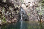
![]() by Chunder fuzz » Fri 06 Apr, 2018 10:36 am
by Chunder fuzz » Fri 06 Apr, 2018 10:36 am
- Chunder fuzz
- Atherosperma moschatum

- Posts: 74
- Joined: Sun 07 Sep, 2014 12:58 pm
- Region: New South Wales
Re: Crawfords LO to Dooli creek
![]() by johnrs » Fri 06 Apr, 2018 10:52 am
by johnrs » Fri 06 Apr, 2018 10:52 am
Heh CF
Sounds like a great trip
I think there is some swimming involved just below Crawfords.
Take your time finding the correct descent there.
Please put up an account and photos
HJohn
Sounds like a great trip
I think there is some swimming involved just below Crawfords.
Take your time finding the correct descent there.
Please put up an account and photos
HJohn
- johnrs
- Phyllocladus aspleniifolius

- Posts: 621
- Joined: Mon 09 Aug, 2010 6:09 pm
- Region: New South Wales
Re: Crawfords LO to Dooli creek
![]() by tom_brennan » Fri 06 Apr, 2018 2:00 pm
by tom_brennan » Fri 06 Apr, 2018 2:00 pm
I have done it without swimming - wading in the river and walking along the banks, mainly the west bank.
I've also done it by lilo from Pass 6.
Obviously conditions change, but I'd be surprised if you needed to swim. The banks can be scrubby in places. You could take a lightweight raft (eg Explorer 100) as it might be easier to paddle than walk the banks downstream from Pass 6. Or it might not
I've also done it by lilo from Pass 6.
Obviously conditions change, but I'd be surprised if you needed to swim. The banks can be scrubby in places. You could take a lightweight raft (eg Explorer 100) as it might be easier to paddle than walk the banks downstream from Pass 6. Or it might not
Bushwalking NSW - http://bushwalkingnsw.com
-

tom_brennan - Athrotaxis selaginoides

- Posts: 1354
- Joined: Wed 29 Sep, 2010 9:21 am
- Location: Sydney
- Region: New South Wales
- Gender: Male
Re: Crawfords LO to Dooli creek
![]() by Chunder fuzz » Fri 06 Apr, 2018 2:40 pm
by Chunder fuzz » Fri 06 Apr, 2018 2:40 pm
Cheers tom. Suck it and see eh...just have to get the right pass down now. Might pack some spare clothes instead of a 4kg raft that may or may not get used...
Will do HJohn.
Will do HJohn.
- Chunder fuzz
- Atherosperma moschatum
- Posts: 74
- Joined: Sun 07 Sep, 2014 12:58 pm
- Region: New South Wales
Re: Crawfords LO to Dooli creek
![]() by mandragara » Sat 07 Apr, 2018 12:01 am
by mandragara » Sat 07 Apr, 2018 12:01 am
Did it a few weeks ago, on that really hot Saturday when it stormed hard the next day.
I'd just stuff everything in dry bags and swim. Why bash through scrub when there's lovely water nearby?
I'd just stuff everything in dry bags and swim. Why bash through scrub when there's lovely water nearby?
-
mandragara - Athrotaxis cupressoides

- Posts: 128
- Joined: Fri 22 Dec, 2017 5:04 pm
- Location: Sydney
- Region: New South Wales
- Gender: Male
Re: Crawfords LO to Dooli creek
![]() by rcaffin » Sat 07 Apr, 2018 8:47 pm
by rcaffin » Sat 07 Apr, 2018 8:47 pm
The top of Crawfords LO may be a bit steep. There was a bit of erosion. A short bit of handline would not go amiss, if only for the packs.
At the bottom you will have to cross the Wollemi R immediately. You might, or you might not, get wet knees. A sandy bottom. From there on south you can walk the banks to the Colo junction. Last time we crossed that it was ankle deep. After that, walk the bank.
Cheers
Roger
At the bottom you will have to cross the Wollemi R immediately. You might, or you might not, get wet knees. A sandy bottom. From there on south you can walk the banks to the Colo junction. Last time we crossed that it was ankle deep. After that, walk the bank.
Cheers
Roger
-

rcaffin - Athrotaxis selaginoides
- Posts: 1226
- Joined: Thu 17 Jul, 2008 3:46 pm
Re: Crawfords LO to Dooli creek
![]() by Chunder fuzz » Sun 08 Apr, 2018 8:31 am
by Chunder fuzz » Sun 08 Apr, 2018 8:31 am
Thanks Roger, will chuck some hand line in.
- Chunder fuzz
- Atherosperma moschatum
- Posts: 74
- Joined: Sun 07 Sep, 2014 12:58 pm
- Region: New South Wales
Re: Crawfords LO to Dooli creek
![]() by Chunder fuzz » Sun 08 Apr, 2018 5:25 pm
by Chunder fuzz » Sun 08 Apr, 2018 5:25 pm
Has anyone been up this pass (the track south of Crawford’s lookdout) marked on OSM? Makes for a shorter walk but wondering what it’s like. Will probably have a look while there anyway .
- Attachments
-
- Chunder fuzz
- Atherosperma moschatum
- Posts: 74
- Joined: Sun 07 Sep, 2014 12:58 pm
- Region: New South Wales
Re: Crawfords LO to Dooli creek
![]() by Warin » Sun 08 Apr, 2018 5:44 pm
by Warin » Sun 08 Apr, 2018 5:44 pm
The one from the very end of the track (named Culoul Range Trail) is described in the 'sac_scale' in OSM as 'demanding_mountain_hiking'. Where as the one further north is is described in the 'sac_scale' in OSM as 'mountain_hiking'.
See
https://www.openstreetmap.org/way/413489812
https://www.openstreetmap.org/way/413489814
See
https://www.openstreetmap.org/way/413489812
https://www.openstreetmap.org/way/413489814
-
Warin - Athrotaxis selaginoides
- Posts: 1419
- Joined: Sat 11 Nov, 2017 8:02 am
- Region: New South Wales
Re: Crawfords LO to Dooli creek
![]() by rcaffin » Sun 08 Apr, 2018 5:46 pm
by rcaffin » Sun 08 Apr, 2018 5:46 pm
Pass 5, Wounded Knee
Abseil route with canyons, ~8 drops. Needs rope and not easily reversed. The above map is not correct anyhow.
Cheers
Roger
Abseil route with canyons, ~8 drops. Needs rope and not easily reversed. The above map is not correct anyhow.
Cheers
Roger
-
rcaffin - Athrotaxis selaginoides
- Posts: 1226
- Joined: Thu 17 Jul, 2008 3:46 pm
Re: Crawfords LO to Dooli creek
![]() by Chunder fuzz » Sun 08 Apr, 2018 6:01 pm
by Chunder fuzz » Sun 08 Apr, 2018 6:01 pm
rcaffin wrote:Pass 5, Wounded Knee
Abseil route with canyons, ~8 drops. Needs rope and not easily reversed. The above map is not correct anyhow.
Cheers
Roger
Won't be going up it then ... will have to go back with my canyoning gear. Yea the various phone map apps leave a bit to be desired.
- Chunder fuzz
- Atherosperma moschatum
- Posts: 74
- Joined: Sun 07 Sep, 2014 12:58 pm
- Region: New South Wales
Re: Crawfords LO to Dooli creek
![]() by Warin » Sun 08 Apr, 2018 6:25 pm
by Warin » Sun 08 Apr, 2018 6:25 pm
Chunder fuzz wrote:rcaffin wrote:. Yea the various phone map apps leave a bit to be desired.
The difficulty is in displaying all the possible/avalible information .... maybe some hover function with a pointer would work. There is a lot more info than on a general paper map.
-
Warin - Athrotaxis selaginoides
- Posts: 1419
- Joined: Sat 11 Nov, 2017 8:02 am
- Region: New South Wales
Re: Crawfords LO to Dooli creek
![]() by tom_brennan » Mon 09 Apr, 2018 8:03 am
by tom_brennan » Mon 09 Apr, 2018 8:03 am
Chunder fuzz wrote:Has anyone been up this pass (the track south of Crawford’s lookdout) marked on OSM? Makes for a shorter walk but wondering what it’s like. Will probably have a look while there anyway .
That's Pass 6. I haven't been up it, but been down it twice. Nice, fairly easy except the bottom, which involves either a handline or a tricky scramble. If you can get up into the gully proper, you should find the rest of the ascent straightforward. Some d***heads cut a track, hacked out steps and maybe even drilled bolts on this pass about 8 years ago - my guess was bass fishermen, but I could be maligning the wrong people. There seems to have been a lot of track cutting in the Colo in recent years - someone also cut a track downstream from Canoe Creek to Little Pass.
rcaffin wrote:Pass 5, Wounded Knee
Abseil route with canyons, ~8 drops. Needs rope and not easily reversed. The above map is not correct anyhow.
Pass 5 is the gully 1.5km upstream, not the one marked on OSM,
Bushwalking NSW - http://bushwalkingnsw.com
-
tom_brennan - Athrotaxis selaginoides
- Posts: 1354
- Joined: Wed 29 Sep, 2010 9:21 am
- Location: Sydney
- Region: New South Wales
- Gender: Male
Re: Crawfords LO to Dooli creek
![]() by tom_brennan » Mon 09 Apr, 2018 8:10 am
by tom_brennan » Mon 09 Apr, 2018 8:10 am
There are some photos of Pass 6 on my website - http://ozultimate.com/tom/bushwalking/log_book.htm - just type Pass 6 into the search box at the top.
Bushwalking NSW - http://bushwalkingnsw.com
-
tom_brennan - Athrotaxis selaginoides
- Posts: 1354
- Joined: Wed 29 Sep, 2010 9:21 am
- Location: Sydney
- Region: New South Wales
- Gender: Male
Re: Crawfords LO to Dooli creek
![]() by Chunder fuzz » Mon 09 Apr, 2018 8:55 am
by Chunder fuzz » Mon 09 Apr, 2018 8:55 am
Cheers, looks reversible enough...
Are the references to pass numbers coming from a book?
Are the references to pass numbers coming from a book?
- Chunder fuzz
- Atherosperma moschatum
- Posts: 74
- Joined: Sun 07 Sep, 2014 12:58 pm
- Region: New South Wales
Re: Crawfords LO to Dooli creek
![]() by tom_brennan » Mon 09 Apr, 2018 11:37 am
by tom_brennan » Mon 09 Apr, 2018 11:37 am
Originally from the NPA (Bob Buck/Geoff Daley) Colo River Sketch Map - usually referred to as Bob Buck's Colo River Sketch Map.
Brian Corlis updated this into a self published guide. Now out of print, but available for reading at say the State Library of NSW.
https://catalogue.nla.gov.au/Record/3419180
Brian Corlis updated this into a self published guide. Now out of print, but available for reading at say the State Library of NSW.
https://catalogue.nla.gov.au/Record/3419180
Bushwalking NSW - http://bushwalkingnsw.com
-
tom_brennan - Athrotaxis selaginoides
- Posts: 1354
- Joined: Wed 29 Sep, 2010 9:21 am
- Location: Sydney
- Region: New South Wales
- Gender: Male
Re: Crawfords LO to Dooli creek
![]() by ribuck » Mon 09 Apr, 2018 11:54 am
by ribuck » Mon 09 Apr, 2018 11:54 am
Chunder fuzz wrote:Are the references to pass numbers coming from a book?
The pass numbers (1 to 38) are from a sketch map by Bob Bucks. Mine is dated "1st Edition 1973". As Tom says, the path you described as "south of Crawfords lookout" is Pass 6. The other one on your screenshot, further north, is Pass 1.
- 20180409_114258.jpg (122.82 KiB) Viewed 11077 times
The sketch map also has a brief note for each pass, although some of these have been superseded over time as conditions change or better routes are found.
- 20180409_114337.jpg (150.42 KiB) Viewed 11077 times
-

ribuck - Athrotaxis selaginoides
- Posts: 1887
- Joined: Wed 15 May, 2013 3:47 am
- Region: Other Country
- Gender: Male
Re: Crawfords LO to Dooli creek
![]() by Chunder fuzz » Mon 09 Apr, 2018 2:23 pm
by Chunder fuzz » Mon 09 Apr, 2018 2:23 pm
Thanks again.
Good info, should be an interesting walk.
Good info, should be an interesting walk.
- Chunder fuzz
- Atherosperma moschatum
- Posts: 74
- Joined: Sun 07 Sep, 2014 12:58 pm
- Region: New South Wales
Re: Crawfords LO to Dooli creek
![]() by rcaffin » Mon 09 Apr, 2018 7:37 pm
by rcaffin » Mon 09 Apr, 2018 7:37 pm
Hi Tom
I dare say you might be right. I have a bit of a headache right now.
Cheers
Roger
I dare say you might be right. I have a bit of a headache right now.
Cheers
Roger
-
rcaffin - Athrotaxis selaginoides
- Posts: 1226
- Joined: Thu 17 Jul, 2008 3:46 pm
19 posts
• Page 1 of 1
Return to New South Wales & ACT
Who is online
Users browsing this forum: No registered users and 54 guests