Hi everyone.
I'm planning a trip into the Jagungal area in a few weeks. I'm after suggestions for our itinerary, best place to start (round mountain?) or any other tips ? We have 3 days.
Jagungal area trip suggestions
Forum rules
NSW & ACT specific bushwalking discussion. Please avoid publishing details of access to sensitive areas with no tracks.
NSW & ACT specific bushwalking discussion. Please avoid publishing details of access to sensitive areas with no tracks.
29 posts
• Page 1 of 1
Jagungal area trip suggestions
![]() by geoffmallo » Mon 01 Feb, 2010 10:01 am
by geoffmallo » Mon 01 Feb, 2010 10:01 am
Blog - http://geoffmallinson.com
-
geoffmallo - Athrotaxis cupressoides

- Posts: 109
- Joined: Mon 21 Apr, 2008 7:53 pm
Re: Jagungal area trip suggestions
![]() by melinda » Mon 01 Feb, 2010 12:33 pm
by melinda » Mon 01 Feb, 2010 12:33 pm
Hi,
Can't help you on Jagungal but the KUK Hiking Documentary on the mycampgearwebsite is sort of cute.
Makes me think of a few bushwalkers I know.
Perhaps you should put that link up here.
Melinda
Can't help you on Jagungal but the KUK Hiking Documentary on the mycampgearwebsite is sort of cute.
Makes me think of a few bushwalkers I know.
Perhaps you should put that link up here.
Melinda
'Life is either a daring adventure or nothing'
-

melinda - Phyllocladus aspleniifolius

- Posts: 580
- Joined: Mon 21 Sep, 2009 2:15 pm
- Location: Illawarra
- Region: New South Wales
- Gender: Female
Re: Jagungal area trip suggestions
![]() by north-north-west » Mon 01 Feb, 2010 12:38 pm
by north-north-west » Mon 01 Feb, 2010 12:38 pm
If you're fit enough for the distance, try Round Mountain, 15Mile Ridge (picking up the start of the track can be a bit iffy), down Happy Jack's Road, over Far Bald, Doubtful Gap, up Jagungal via the scrub bash along Farm Ridge, and back along either the usual route, or the Farm Ridge Track. It'd be a hard three days (by my standards) but doable.
15 Mile is rarely travelled, but it's a stunning little ridgeline, with brilliant views.
15 Mile is rarely travelled, but it's a stunning little ridgeline, with brilliant views.
"Mit der Dummheit kämpfen Götter selbst vergebens."
-

north-north-west - Lagarostrobos franklinii

- Posts: 15123
- Joined: Thu 14 May, 2009 7:36 pm
- Location: The Asylum
- ASSOCIATED ORGANISATIONS: Social Misfits Anonymous
- Region: Tasmania
Re: Jagungal area trip suggestions
![]() by Tony » Mon 01 Feb, 2010 1:07 pm
by Tony » Mon 01 Feb, 2010 1:07 pm
Hi Geoff,
Round Mountain is the best place to start for a walk to Jagungal, it is an easy walk to Jagungal via both Round Mountain fire trail and Farm Yard Ridge fire trail though I prefer Farm yard Ridge fire trail.
There is a good track up the western side of Jagungal starting from where the Grey mare fire trail/Alpine Walking track crosses the Tumut River, though it is possible to climb up the northern side. There is good tent camping sites at O’Keefes and Grey Mare huts.
If you have time Valentines Falls is worth a visit, Grey Mare Hut and Grey Mare mine diggings and old machinery that are in the trees behind are also very interesting (see if you can spot the art works in Grey Mare hut).
The track from Grey Mare fire trail to Valentines falls is good but the track along side of Ghost Hill from the falls to Valentines Hut is somewhat overgrown and can be a slog.
As Scavenger suggested 15 mile ridge is very nice, I did a lot of his suggested walk last January in three days with time to fish, and as he suggested we had some difficulty in finding some parts of the 15 mile ridge track early on.
I hope this helps
Tony
There is no such thing as bad weather.....only bad clothing. Norwegian Proverb
-
Tony - Athrotaxis selaginoides

- Posts: 1896
- Joined: Fri 16 May, 2008 1:40 pm
- Location: Canberra
- Region: Australian Capital Territory
Re: Jagungal area trip suggestions
![]() by climberman » Mon 01 Feb, 2010 4:32 pm
by climberman » Mon 01 Feb, 2010 4:32 pm
For a different tack you could come in from teh Eucumbene Dam end. Park before the gate on Happy Jacks Road (there is a small borrow pit which has been turned into a parking area (by the addition of a sign), and then wander up a bit until striking off on a fenceline bearing towards the big J. You would join on the Grey Mare FT. This would likely give you time to do a side trip on the centre day.
- climberman
- Phyllocladus aspleniifolius
- Posts: 656
- Joined: Tue 09 Dec, 2008 7:32 pm
Re: Jagungal area trip suggestions
![]() by sef » Tue 02 Feb, 2010 12:06 am
by sef » Tue 02 Feb, 2010 12:06 am
the best of the jagungal wilderness (in my opinion) is immediately to the north of j. three full-ish days:
1. munyang --> disappointment spur ft --> schlink pass --> kerries --> mawsons hut
2. mawsons --> ~cup and saucer/bluff tarn/geehi forks --> jagungal --> down the track to the head of the tumut --> grey mare hut or thereabouts.
3. grey mare --> valentine falls -->valentine hut --> schlink --> surge tank/aqueduct trail --> munyang
a mixture of on and off track and next to no scrub (alpine country and frost hollows) and some awesome country.
round mountain is probably the best approach from the south, but i'd skip the happy jacks approach. 15 mile ridge is scenic (http://4.bp.blogspot.com/_ieUAccnh5vQ/S ... G_3237.jpg) but trudging down to the dam and then back up the other side on a dirty big dirt road isn't exactly idyllic.
if you head a few km down towards khancoban, you could start from tooma dam and head up to pretty plain, over the range to grey mare hut, up jagungal, then back along round mountain fire trail to cool plain and a bit of a bash down olgivies ck to the quarry and the dam again. that'd be a good three days, and pretty plain is a very nice plain indeed. some of the fire trails on the map are no more though.
- sef
- Atherosperma moschatum

- Posts: 87
- Joined: Sun 20 Dec, 2009 8:07 pm
- Region: Queensland
Re: Jagungal area trip suggestions
![]() by WarrenH » Tue 02 Feb, 2010 5:44 am
by WarrenH » Tue 02 Feb, 2010 5:44 am
Sef, 8 kilometres NNW of Jagungal, is Mount Toolong. On the VMTC sketch map ROUND MOUNTAIN AREA, AND THE NORTHERN APPROACHES TO MT JAGUNGAL, it reads, "Compasses are unreliable in this vicinity."
I'd like to suggest you do not take your bearings to Mt Jagungal from Mt Toolong. Is this what has happened?
I'd like to suggest you do not take your bearings to Mt Jagungal from Mt Toolong. Is this what has happened?
- WarrenH
- Phyllocladus aspleniifolius
- Posts: 991
- Joined: Thu 07 Jan, 2010 6:54 pm
- Region: Australian Capital Territory
Re: Jagungal area trip suggestions
![]() by WarrenH » Tue 02 Feb, 2010 6:15 am
by WarrenH » Tue 02 Feb, 2010 6:15 am
Geoff, on maps the Grey Mare Bogong, looks innocuous. Grey Mare Bogong is one of the most fascinating places not on the moon. That region of the western part of the Strumbo Range is well worth exploring. If you've been to and enjoyed the Rams Heads you will like the Grey Mare Bogong. The upper reaches of the Geehi are good too. I spent a week on my last trip just looking at the creeks around the sleeping Lion, I should have spent a month.
The recommendations for the Farm Ridge route, from the earlier posts ... absolutely!
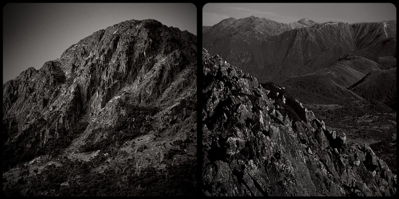
The first two shots. From Round Mountain to the sleeping Lion and the second shot shows the upper reaches of the Geehi.
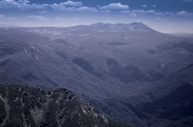
The Lion and across to the Main Range.
Warrren.
The recommendations for the Farm Ridge route, from the earlier posts ... absolutely!
The first two shots. From Round Mountain to the sleeping Lion and the second shot shows the upper reaches of the Geehi.
The Lion and across to the Main Range.
Warrren.
Last edited by WarrenH on Wed 03 Feb, 2010 3:01 pm, edited 2 times in total.
- WarrenH
- Phyllocladus aspleniifolius
- Posts: 991
- Joined: Thu 07 Jan, 2010 6:54 pm
- Region: Australian Capital Territory
Re: Jagungal area trip suggestions
![]() by sef » Tue 02 Feb, 2010 7:07 am
by sef » Tue 02 Feb, 2010 7:07 am
no? what?
if you can't navigate using a combination of features and compass, don't go off track. hypothetically, and reading off the topo, even if you were to want to walk right past mt toolong and really really really wanted to break in your new silva:
1. 2km to the east is a fire trail.
2. there are creeks producing frost hollows running *downhill* to the north/south
3. it's possible to see both jagungal and round mountain from the vicinity.
- sef
- Atherosperma moschatum
- Posts: 87
- Joined: Sun 20 Dec, 2009 8:07 pm
- Region: Queensland
Re: Jagungal area trip suggestions
![]() by WarrenH » Tue 02 Feb, 2010 7:20 am
by WarrenH » Tue 02 Feb, 2010 7:20 am
sef wrote:"no? what?"
I thought Round Mountain was North of the sleeping Lion and Munyang to the South? ... that's what!
The Lion and the sleeping Lion, were the names given to Jagungal in the early days of bushwalking.
Warren.
Last edited by WarrenH on Tue 02 Feb, 2010 7:32 am, edited 1 time in total.
- WarrenH
- Phyllocladus aspleniifolius
- Posts: 991
- Joined: Thu 07 Jan, 2010 6:54 pm
- Region: Australian Capital Territory
Re: Jagungal area trip suggestions
![]() by sef » Tue 02 Feb, 2010 7:25 am
by sef » Tue 02 Feb, 2010 7:25 am
separate itineraries, dude.
... "round mountain is probably the best approach from the south"
... "round mountain is probably the best approach from the south"
- sef
- Atherosperma moschatum
- Posts: 87
- Joined: Sun 20 Dec, 2009 8:07 pm
- Region: Queensland
Re: Jagungal area trip suggestions
![]() by WarrenH » Tue 02 Feb, 2010 7:34 am
by WarrenH » Tue 02 Feb, 2010 7:34 am
Sef, Round mountain is one of the northern approaches to Jagungal. Munyang is a southern approach ... I suggest you do not go off track or better still learn the terminology of navigation.
A northwesterly wind does not blow/head north west ... it comes from the north west. That is the same thing.
A northwesterly wind does not blow/head north west ... it comes from the north west. That is the same thing.
- WarrenH
- Phyllocladus aspleniifolius
- Posts: 991
- Joined: Thu 07 Jan, 2010 6:54 pm
- Region: Australian Capital Territory
Re: Jagungal area trip suggestions
![]() by geoffmallo » Tue 02 Feb, 2010 9:41 am
by geoffmallo » Tue 02 Feb, 2010 9:41 am
Thanks for all the suggestions. I think I need 3 months - if only. I haven't decided which we'll do yet.
The link to the hiking mockumentary is http://mycampgear.com/2010/01/28/hiking-mockumentary
The link to the hiking mockumentary is http://mycampgear.com/2010/01/28/hiking-mockumentary
Blog - http://geoffmallinson.com
-
geoffmallo - Athrotaxis cupressoides
- Posts: 109
- Joined: Mon 21 Apr, 2008 7:53 pm
Re: Jagungal area trip suggestions
![]() by sef » Tue 02 Feb, 2010 3:02 pm
by sef » Tue 02 Feb, 2010 3:02 pm
haha. okay, i deserve that. brain typo, should have read north.
- sef
- Atherosperma moschatum
- Posts: 87
- Joined: Sun 20 Dec, 2009 8:07 pm
- Region: Queensland
Re: Jagungal area trip suggestions
![]() by north-north-west » Wed 03 Feb, 2010 12:21 pm
by north-north-west » Wed 03 Feb, 2010 12:21 pm
Yeah, any suggestions for the Grey Mare Bogong area and Kerries are spot on. Kerries isn't quite Jagungal itself, but it's the next best thing. You could spend ages scrambling over all the rocks up there, if that's your thing.
Only issue with the Strumbo track is the section that runs down the back of the range to join with the Dargalls. That is so overgrown with gum suckers and the like that it's easier to walk off the 'track' and just use the thickest scrub as a guide for the route. But that's a short stretch, and all you have to do is keep going straight downhill.
Oh, and a couple of short overgrown bits on the other side, but that's part of the challenge, isn't it?
"Mit der Dummheit kämpfen Götter selbst vergebens."
-
north-north-west - Lagarostrobos franklinii
- Posts: 15123
- Joined: Thu 14 May, 2009 7:36 pm
- Location: The Asylum
- ASSOCIATED ORGANISATIONS: Social Misfits Anonymous
- Region: Tasmania
Re: Jagungal area trip suggestions
![]() by north-north-west » Wed 03 Feb, 2010 12:34 pm
by north-north-west » Wed 03 Feb, 2010 12:34 pm
Tony wrote:As Scavenger suggested 15 mile ridge is very nice, I did a lot of his suggested walk last January in three days with time to fish, and as he suggested we had some difficulty in finding some parts of the 15 mile ridge track early on.
Her. She. Please.
The easiest way to pick it up is to start from the carpark. Down to the road and back along it (towards Cabramurra) for about 100 metres, to the lowest point, on the curve. There's an obvious old vehicle track starts up the hill from there - it even has a small barrier to prevent bush-bashers 4wding over it. Follow that, using the old Hydro ski poles, for a few hundred yards, curving around to the left as the scrub gets thicker. You should come out on an open grassy stretch with the new snow trap nearby - maybe a little to your left. The track runs right past it.
It's a great place for a ramble, like the Kerries, you can ignore the track in good weather and just meander hither, thither and yon, while you keep heading generally north. Just have to find the right way down to Happy Jack's Road.
"Mit der Dummheit kämpfen Götter selbst vergebens."
-
north-north-west - Lagarostrobos franklinii
- Posts: 15123
- Joined: Thu 14 May, 2009 7:36 pm
- Location: The Asylum
- ASSOCIATED ORGANISATIONS: Social Misfits Anonymous
- Region: Tasmania
Re: Jagungal area trip suggestions
![]() by WarrenH » Wed 03 Feb, 2010 3:49 pm
by WarrenH » Wed 03 Feb, 2010 3:49 pm
"Oh, and a couple of short overgrown bits on the other side, but that's part of the challenge, isn't it?" - Scavanger.
No it isn't Sir! Certainly not as far as my Mates were concerned ... the day we climbed Gaungarlin West and I promised my buddies extraordinary views of a not often visited part of the mountains (at the time) and all we saw was a never ending wall of dense bush.
I talked a couple of friends into going into Kidman's Hut we went in via Dead Horse Creek. I told them that I reckoned that if we went ENE of Kidmans across the snow grass, crossed the Burrungubugge River and linked together a few clearings we would do Gungarlin West with no effort. Then we would keep linking the clearings back to that "McWhatsitsname Saddle" called McAlister.
I was just looking at the map that I took on that trip, to get the names of the creeks and I'd forgotten that every clearing we walk through, I'd shaded-in using pencil to show that no clearing actually existed. One could only describe that trip as the scrub bash from hell until we reached the clearings west of the Bull's Peaks and then climbed Jagungal. I don't trust the maps in the Jagungal precinct as being even slightly faithful when off track, that's for sure. I should buy the new series maps with the photo on the back, the old series maps are suck-it-and-sees.
On another trip, I asked one of my Mates, the best walker I've ever been with, if I could look at his map, when he had his pack off and he said to me, "I didn't bring one. There's no point having a map up here." Walking without maps is certainly not a bush sense that every walker has in thick country. My Mate used to say, "If I get lost I'll just walk down hill." Not once did we get lost sadly, I was really looking forward to doing a truly epic walk around Jagungal.
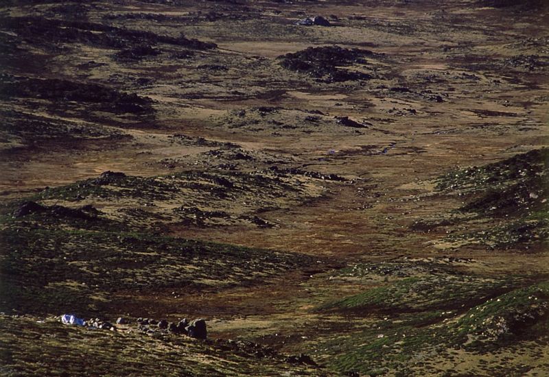
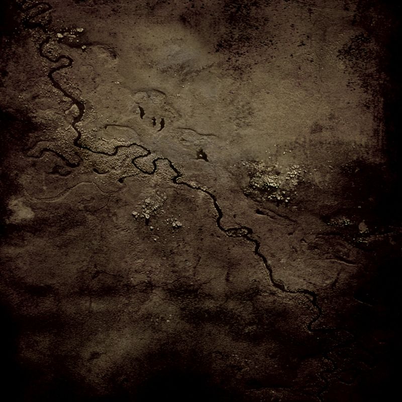
'Three Rocks in the Creek'. Composite digital image of the upper Geehi River. 2009.
Warren.
No it isn't Sir! Certainly not as far as my Mates were concerned ... the day we climbed Gaungarlin West and I promised my buddies extraordinary views of a not often visited part of the mountains (at the time) and all we saw was a never ending wall of dense bush.
I talked a couple of friends into going into Kidman's Hut we went in via Dead Horse Creek. I told them that I reckoned that if we went ENE of Kidmans across the snow grass, crossed the Burrungubugge River and linked together a few clearings we would do Gungarlin West with no effort. Then we would keep linking the clearings back to that "McWhatsitsname Saddle" called McAlister.
I was just looking at the map that I took on that trip, to get the names of the creeks and I'd forgotten that every clearing we walk through, I'd shaded-in using pencil to show that no clearing actually existed. One could only describe that trip as the scrub bash from hell until we reached the clearings west of the Bull's Peaks and then climbed Jagungal. I don't trust the maps in the Jagungal precinct as being even slightly faithful when off track, that's for sure. I should buy the new series maps with the photo on the back, the old series maps are suck-it-and-sees.
On another trip, I asked one of my Mates, the best walker I've ever been with, if I could look at his map, when he had his pack off and he said to me, "I didn't bring one. There's no point having a map up here." Walking without maps is certainly not a bush sense that every walker has in thick country. My Mate used to say, "If I get lost I'll just walk down hill." Not once did we get lost sadly, I was really looking forward to doing a truly epic walk around Jagungal.
'Three Rocks in the Creek'. Composite digital image of the upper Geehi River. 2009.
Warren.
- WarrenH
- Phyllocladus aspleniifolius
- Posts: 991
- Joined: Thu 07 Jan, 2010 6:54 pm
- Region: Australian Capital Territory
Re: Jagungal area trip suggestions
![]() by north-north-west » Fri 05 Feb, 2010 12:03 pm
by north-north-west » Fri 05 Feb, 2010 12:03 pm
WarrenH wrote:"Oh, and a couple of short overgrown bits on the other side, but that's part of the challenge, isn't it?" - Scavanger.
No it isn't Sir!
With all due respect (and, by the way, I'm as fond as the next not entirely insane non-masochistic bushwalker of forcing my way uphill through head-high prostanthera) you haven't scrub-bashed until you've scrub-bashed South West Tassie. The Snowies are a walk in the park in comparison.
So, next time your mates complain, take them through some really thick growth. The Prince of Wales Range, perhaps . . .
"Mit der Dummheit kämpfen Götter selbst vergebens."
-
north-north-west - Lagarostrobos franklinii
- Posts: 15123
- Joined: Thu 14 May, 2009 7:36 pm
- Location: The Asylum
- ASSOCIATED ORGANISATIONS: Social Misfits Anonymous
- Region: Tasmania
Re: Jagungal area trip suggestions
![]() by rcaffin » Thu 18 Mar, 2010 3:47 pm
by rcaffin » Thu 18 Mar, 2010 3:47 pm
WarrenH wrote:I talked a couple of friends into going into Kidman's Hut we went in via Dead Horse Creek. I told them that I reckoned that if we went ENE of Kidmans across the snow grass, crossed the Burrungubugge River and linked together a few clearings we would do Gungarlin West with no effort. Then we would keep linking the clearings back to that "McWhatsitsname Saddle" called McAlister.
Plenty of ways to Kidmans without fighting the scrub. But pre-planned compass courses may not work! You need to 'understand' the country and use the frost hollows and snow grass areas.
I don't trust the maps in the Jagungal precinct as being even slightly faithful when off track, that's for sure.
The old ones are pretty accurate. That's all we ever use.
Cheers
-

rcaffin - Athrotaxis selaginoides
- Posts: 1226
- Joined: Thu 17 Jul, 2008 3:46 pm
Re: Jagungal area trip suggestions
![]() by WarrenH » Mon 22 Mar, 2010 5:41 pm
by WarrenH » Mon 22 Mar, 2010 5:41 pm
Most of my maps are old, that is all I use and they are were not accurate in regards to the clearings in that region.
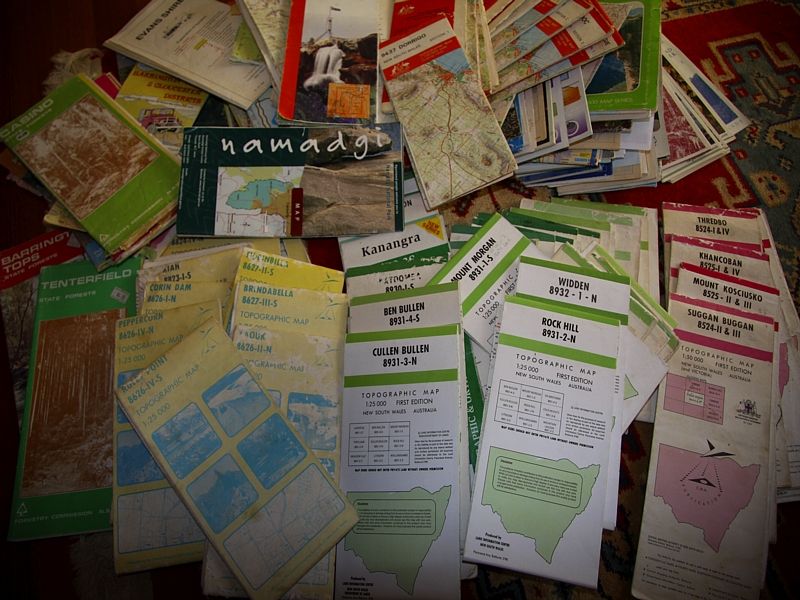
This is my NSW section of the National Bicentennial Trail, collection. Jagungal is on the BNT as you all know.
Warren.
(post edited by admin)
This is my NSW section of the National Bicentennial Trail, collection. Jagungal is on the BNT as you all know.
Warren.
(post edited by admin)
- WarrenH
- Phyllocladus aspleniifolius
- Posts: 991
- Joined: Thu 07 Jan, 2010 6:54 pm
- Region: Australian Capital Territory
Re: Jagungal area trip suggestions
![]() by north-north-west » Mon 22 Mar, 2010 6:38 pm
by north-north-west » Mon 22 Mar, 2010 6:38 pm
Blimey! How do you manage to make them last that long? I've already been through two Jagungal maps and have started on the third.
"Mit der Dummheit kämpfen Götter selbst vergebens."
-
north-north-west - Lagarostrobos franklinii
- Posts: 15123
- Joined: Thu 14 May, 2009 7:36 pm
- Location: The Asylum
- ASSOCIATED ORGANISATIONS: Social Misfits Anonymous
- Region: Tasmania
Re: Jagungal area trip suggestions
![]() by WarrenH » Tue 23 Mar, 2010 7:45 pm
by WarrenH » Tue 23 Mar, 2010 7:45 pm
As far as going past Jagungal, I checked that fact recently with the NSW Parks and Wildlife Service and was told that the BNT there is flexible similar to how the BNT works here in the ACT. There isn't one track but several that are dual purpose tracks. Go and read the BNT information to cyclists booklet.
Good bye.
Warren.,
(post edited by admin)
Good bye.
Warren.,
(post edited by admin)
Last edited by WarrenH on Tue 23 Mar, 2010 8:03 pm, edited 3 times in total.
- WarrenH
- Phyllocladus aspleniifolius
- Posts: 991
- Joined: Thu 07 Jan, 2010 6:54 pm
- Region: Australian Capital Territory
Re: Jagungal area trip suggestions
![]() by north-north-west » Tue 23 Mar, 2010 9:07 pm
by north-north-west » Tue 23 Mar, 2010 9:07 pm
Fair enough. I tend to think of the BNT as a horse track, I keep forgetting it's for cyclists as well. And hard enough as it would be for horses to get down the track from 15 Mile to Happy Jacks, it'd be even worse on wheels.
"Mit der Dummheit kämpfen Götter selbst vergebens."
-
north-north-west - Lagarostrobos franklinii
- Posts: 15123
- Joined: Thu 14 May, 2009 7:36 pm
- Location: The Asylum
- ASSOCIATED ORGANISATIONS: Social Misfits Anonymous
- Region: Tasmania
Re: Jagungal area trip suggestions
![]() by WarrenH » Wed 24 Mar, 2010 12:05 am
by WarrenH » Wed 24 Mar, 2010 12:05 am
The BNT was originally a horse trail called the National Horse Trail. Cavaliers and postilions are the minor users ... cyclists, dog runners (who are not allowed on the BNT) and walkers are the heaviest users,so now the NHT is called the BNT, the Bicentennial National Trail.
I like the BNT, it is my favourite track, I've spent months exploring it. I've done much of the NSW trail and all of the ACT trail. I've many images of the BNT. I should start a BNT thread for we BNT aficionados.
The BNT is tres cool ... get with the programme.
Warren.
I like the BNT, it is my favourite track, I've spent months exploring it. I've done much of the NSW trail and all of the ACT trail. I've many images of the BNT. I should start a BNT thread for we BNT aficionados.
The BNT is tres cool ... get with the programme.
Warren.
- WarrenH
- Phyllocladus aspleniifolius
- Posts: 991
- Joined: Thu 07 Jan, 2010 6:54 pm
- Region: Australian Capital Territory
Re: Jagungal area trip suggestions
![]() by geoffmallo » Wed 24 Mar, 2010 11:02 am
by geoffmallo » Wed 24 Mar, 2010 11:02 am
Back to my original topic I unfortunately didn't make the trip at all because of sudden back surgery. Now I'm off walking for a while, but thanks all for your suggestions. I'll be going after winter.
Blog - http://geoffmallinson.com
-
geoffmallo - Athrotaxis cupressoides
- Posts: 109
- Joined: Mon 21 Apr, 2008 7:53 pm
Re: Jagungal area trip suggestions
![]() by kanangra » Wed 24 Mar, 2010 11:13 am
by kanangra » Wed 24 Mar, 2010 11:13 am
Hope your feeling better soon Geoff. If you need the help of a compensation lawyer give me a call.
K.
K.
- kanangra
- Athrotaxis selaginoides
- Posts: 1335
- Joined: Sun 25 May, 2008 3:52 pm
Re: Jagungal area trip suggestions
![]() by Son of a Beach » Thu 25 Mar, 2010 7:51 am
by Son of a Beach » Thu 25 Mar, 2010 7:51 am
Note that the offensive posts in this topic, and replies to them have been deleted and/or edited to comply with forum rules.
Further offenses may result in official warnings or temporary bannings.
Further offenses may result in official warnings or temporary bannings.
- Son of a Beach
- Lagarostrobos franklinii
- Posts: 7024
- Joined: Thu 01 Mar, 2007 7:55 am
- ASSOCIATED ORGANISATIONS: Bit Map (NIXANZ)
- Region: Tasmania
- Gender: Male
Re: Jagungal area trip suggestions
![]() by rcaffin » Wed 14 Apr, 2010 5:40 pm
by rcaffin » Wed 14 Apr, 2010 5:40 pm
WarrenH wrote:I don't trust the maps in the Jagungal precinct as being even slightly faithful when off track, that's for sure.
rcaffin wrote:The old ones are pretty accurate. That's all we ever use.
Well, a couple of weeks ago we came over the saddle from Bulls Peak Creek, down the Burrungubugge to Kidmans Hut, up a spur to Dead Horse Creek, S down that a way, and then up to a saddle S of Big Brassy. I think we may have met 200 m of light scrub on the way. The rest was quite good going. Clearings were as shown on the Khancoban 8525-I 1:50k 1986 topo.
Granted, the wind over the Brassies was clocking about 100 kph and knocking us over, but it was fine and sunny.
8 days: Cesjacks to Thredbo via Brassies and Ramshead range, then back via Main Range and Grey Mare, cross country to Cesjacks.
Cheers
-
rcaffin - Athrotaxis selaginoides
- Posts: 1226
- Joined: Thu 17 Jul, 2008 3:46 pm
Re: Jagungal area trip suggestions
![]() by north-north-west » Thu 15 Apr, 2010 6:43 pm
by north-north-west » Thu 15 Apr, 2010 6:43 pm
WarrenH wrote:I don't trust the maps in the Jagungal precinct as being even slightly faithful when off track, that's for sure.
I don't trust CDMA 1:25,000 maps, period. They have a tendency to omit various minor features - like 20m+ waterfalls - as well as giving highly erroneous ideas of the nature of the terrain, due to the 20m contour intervals.
"Mit der Dummheit kämpfen Götter selbst vergebens."
-
north-north-west - Lagarostrobos franklinii
- Posts: 15123
- Joined: Thu 14 May, 2009 7:36 pm
- Location: The Asylum
- ASSOCIATED ORGANISATIONS: Social Misfits Anonymous
- Region: Tasmania
29 posts
• Page 1 of 1
Return to New South Wales & ACT
Who is online
Users browsing this forum: No registered users and 41 guests