I was planning to do a walk from Morrisons to Drummer's Flats next week, along the Goulburn River.
Talking to the ranger the other day, the river is up quite a bit - waist deep in the area I was intending to go. It will go down quickly, but will still be fairly deep by the time we are there.
Now this would not be a problem if we could walk on the banks. But since the cattle were removed, the banks are overgrown with all the nasty prickly weeds you can imagine. The only place you can walk is in the river itself.
So I am looking for alternative places to go. I had thought of walking in the headwaters of the Goulburn near Ulan, a place called The Drip. Hopefully the water will not be such an issue there.
I was wondering if anyone had ever walked in that area and could give me a few pointers as to campsites and things to see.
Thanks
David
Goulburn River NP
Forum rules
NSW & ACT specific bushwalking discussion. Please avoid publishing details of access to sensitive areas with no tracks.
NSW & ACT specific bushwalking discussion. Please avoid publishing details of access to sensitive areas with no tracks.
7 posts
• Page 1 of 1
Goulburn River NP
![]() by davidmorr » Thu 12 Aug, 2010 6:40 pm
by davidmorr » Thu 12 Aug, 2010 6:40 pm
This post is copyright by davidmorr. Permission to reproduce elsewhere may be granted on application. Please PM me for details.
- davidmorr
- Athrotaxis cupressoides

- Posts: 448
- Joined: Tue 09 Feb, 2010 11:39 pm
- Location: Newcastle
- Region: New South Wales
- Gender: Male
Re: Goulburn River NP
![]() by WarrenH » Sat 14 Aug, 2010 4:30 pm
by WarrenH » Sat 14 Aug, 2010 4:30 pm
Dave, are you intending to enter GRNP from the Bylong Road coming from Baerami/Sandy Hollow? If you are, there is feature above Phipps Cutting (2.9 kilometres along the Bylong Road west of Baerami) which is just a whistle stop but well worth visiting. It is the old flood-free wagon road and it is in its original condition with all the hand placed stone work still intact. It is only a very short track (half and hour at the most) and the lookout over the valley is something else.
You can enter the track at either end of Phipps Cutting, from the north at the TSR gate above the road or from the NPWS picnic tables at the other end of the cutting. If you like a bit of history, you might find this whistle stop where the old track runs past the lookout, worth the trouble.
Three years ago I spent a week in GRNP, I intended to spend a lot longer, I found the main camp sites very dirty, with much rubbish from the 4x4. About the weeds, NPWS have allowed the weeds to become a freek'n disaster not just in the GRNP. Llantana rules. Consider buying a Bolo machete and getting a sheath at the same time. The mistake I made with my machete was I expected to be able to buy a sheath anywhere.
If you haven't been into Widden Valley and Myrtle Creek, good side trips to look up at the Geryon, Cat's Ears, Hool Em Boy Point, the Christmas Pudding, amongst the other extraordinary features. If you want to see more than just the views, let me know. I've the phone numbers, for access.
If you are heading to GRNP from Aberdeen, have you seen Bell's Gap? ... I've got the access phone numbers.
In Sandy Hollow the problem is, people spend too long there tasting the wines, they get distracted and don't ever make it to GRNP. So Bell's Gap is a good rest-of-the-weekend alternative and it saves on petrol.
Warren.
- WarrenH
- Phyllocladus aspleniifolius

- Posts: 991
- Joined: Thu 07 Jan, 2010 6:54 pm
- Region: Australian Capital Territory
Re: Goulburn River NP
![]() by davidmorr » Sat 14 Aug, 2010 9:46 pm
by davidmorr » Sat 14 Aug, 2010 9:46 pm
I didn't know that. I have driven past there many times, and even stopped at the rest area a few times. But I have never walked up the track. Will have to do so next week.WarrenH wrote:Dave, are you intending to enter GRNP from the Bylong Road coming from Baerami/Sandy Hollow? If you are, there is feature above Phipps Cutting (2.9 kilometres along the Bylong Road west of Baerami) which is just a whistle stop but well worth visiting. It is the old flood-free wagon road and it is in its original condition with all the hand placed stone work still intact. It is only a very short track (half and hour at the most) and the lookout over the valley is something else.
You can enter the track at either end of Phipps Cutting, from the north at the TSR gate above the road or from the NPWS picnic tables at the other end of the cutting. If you like a bit of history, you might find this whistle stop where the old track runs past the lookout, worth the trouble.
I've never stayed in the official campsites. Mostly I have backpacked in the Morrisons and Drummers Flats areas. In years gone by, walking down the river was often accompanied by 4WD groups showing how little they knew about driving in river sand.Three years ago I spent a week in GRNP, I intended to spend a lot longer, I found the main camp sites very dirty, with much rubbish from the 4x4. About the weeds, NPWS have allowed the weeds to become a freek'n disaster not just in the GRNP. Llantana rules. Consider buying a Bolo machete and getting a sheath at the same time. The mistake I made with my machete was I expected to be able to buy a sheath anywhere.
Now they can get in to Morrisons Flat, but must camp there - they cannot go up or down the river.
The weeds in this area do not include lantana, but there are plenty of Ngoora Burr (which the ranger says is a lost cause), stickybeaks (cobblers pegs, farmers friends), prickly pear, tiger pear (ouch!) and numerous others.
Been to Widden many times. We used to have contacts at the far end that we had known for 30 years. Sadly they sold up about 10 years ago which limited our access.If you haven't been into Widden Valley and Myrtle Creek, good side trips to look up at the Geryon, Cat's Ears, Hool Em Boy Point, the Christmas Pudding, amongst the other extraordinary features. If you want to see more than just the views, let me know. I've the phone numbers, for access.
Hahahaha Can't help thinking these people are not serious walkers!If you are heading to GRNP from Aberdeen, have you seen Bell's Gap? ... I've got the access phone numbers.
In Sandy Hollow the problem is, people spend too long there tasting the wines, they get distracted and don't ever make it to GRNP. So Bell's Gap is a good rest-of-the-weekend alternative and it saves on petrol.
Cheers
David
This post is copyright by davidmorr. Permission to reproduce elsewhere may be granted on application. Please PM me for details.
- davidmorr
- Athrotaxis cupressoides
- Posts: 448
- Joined: Tue 09 Feb, 2010 11:39 pm
- Location: Newcastle
- Region: New South Wales
- Gender: Male
Re: Goulburn River NP
![]() by WarrenH » Sun 15 Aug, 2010 4:45 am
by WarrenH » Sun 15 Aug, 2010 4:45 am
"The weeds in this area do not include lantana."
Noogoora Bush (Xanthium oxidentale) is an associated plant of Lantana, and a co-occurring (replacement) plant after the removal of Lantana. I call all of the associated weeds of Lantana, Lantana. 5% of Australia's land mass is now infested with Lantana.
Dave, (this might be of interest) along the northern section of Stephen's Flat starting on the Goulburn River going over Australian Gap to finishing just below the confluence of the Goulburn and Merriwa Rivers is an extant Travelling Stock Route which looks like it is about 10 Chains (200m) wide and about 4 kilometres long.
New info about Castlerock Peak, further to the note. It is still listed in the directory of the NSW TSRs as Bates Travelling Stock Reserve. On the new 1:100,000 topos the TSR isn't showing. It is possible that Bates or Castlerock TSR was one of those sold-off by the NSW Government, that is why access may no longer be possible. The Scone District LHPA Rangers, Craig Crooks or Steve Kemp will know ... 6545 1644.
If Castlerock Peak is still a TSR or still Crown Land, the landholder has no rights to block access to anyone. The permission for access and camping is granted by LHPA Rangers if it is still a TSR. I think it is only the Governor General who can deny access to Crown Land if you can produce your Australian Passport if challenged. You can also legally roadside camp anywhere. An old law that is still in existence, available to long distance travellers. You can also legally enter a property to get water if needed, without it being trespass.
If you whip out your Australian Passport which has a standard statement asking for the bearer to be given all assistance in having travel without delay or hindrance etc. if they had a problem with this, they could always ask to speak to the GG, or if she isn't available they could contact Elizabeth. Try this on a National Park Ranger, if they deny access to anywhere or they don't like where you want to camp. It freeks them out.
Warren.
- WarrenH
- Phyllocladus aspleniifolius
- Posts: 991
- Joined: Thu 07 Jan, 2010 6:54 pm
- Region: Australian Capital Territory
Re: Goulburn River NP
![]() by Greenie » Sun 15 Aug, 2010 7:16 pm
by Greenie » Sun 15 Aug, 2010 7:16 pm
That whole last paragraph made me laugh.
I know it's the law, but it would be good if little know facts like this were published or more commonly known.
How can you tell what is crown land and what isn't, other than national park?
Do you have one of your great pic's you would like to share of the GRNP Warren?
Thanks
I know it's the law, but it would be good if little know facts like this were published or more commonly known.
How can you tell what is crown land and what isn't, other than national park?
Do you have one of your great pic's you would like to share of the GRNP Warren?
Thanks
-
Greenie - Athrotaxis cupressoides
- Posts: 321
- Joined: Mon 07 Dec, 2009 3:26 pm
- Region: New South Wales
- Gender: Male
Re: Goulburn River NP
![]() by WarrenH » Tue 17 Aug, 2010 6:35 am
by WarrenH » Tue 17 Aug, 2010 6:35 am
Greenie, G'day.
In the key of a map, Crown Land can be described as; Crown Land, Vacant Land, Reserve Land or simply called Reserve or Reserved. Topo maps are the most awkward to use to identify Crown Land because of the illegible boundary markings. For identifying still wild Crown Land I like maps like the NSW State Forest maps or directories showing the reserves. Airports and utilities are on Crown Land.
It is considered that all public lands belong to the Crown. Lands reserved for nature conservation are the most evident as you mentioned but a lot of what appears to be prime rural lands and forests, being the property of others, isn't. There are areas of Vacant Land that are larger than many National Parks. The Vacant Land north of Mount Boss State Forrest reaching to the Styx River State Forest, is larger than New England National Park.
I scanned a couple of maps showing Crown Land, shown in yellow ... from the Bathurst Region where much gold is being locked away http://i225.photobucket.com/albums/dd30 ... BRGRCL.jpg or showing how Travelling Stock Routes and Reserves on the New England Tableland have been described http://i225.photobucket.com/albums/dd30 ... FRNPCL.jpg
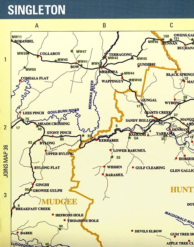
... or from a directory where you need to cross reference the reserves (the green stars) by using more detailed maps, ... from the Goulburn Rivers Region.
One of the reasons why I like the wild Crown Land is that it is the original vegetation of Australia, on the most productive land this country has. The Travelling Stock Routes and Reserves which I'm especially fond of, are our Nation's ribbons of genetic inheritance. It is a shame that the cash strapped and greedy NSW state Government has sold off much Crown Land during the last two decades. Over 700,000 ha. have been sold-off, from the Stock Routes alone.
Warren.
In the key of a map, Crown Land can be described as; Crown Land, Vacant Land, Reserve Land or simply called Reserve or Reserved. Topo maps are the most awkward to use to identify Crown Land because of the illegible boundary markings. For identifying still wild Crown Land I like maps like the NSW State Forest maps or directories showing the reserves. Airports and utilities are on Crown Land.
It is considered that all public lands belong to the Crown. Lands reserved for nature conservation are the most evident as you mentioned but a lot of what appears to be prime rural lands and forests, being the property of others, isn't. There are areas of Vacant Land that are larger than many National Parks. The Vacant Land north of Mount Boss State Forrest reaching to the Styx River State Forest, is larger than New England National Park.
I scanned a couple of maps showing Crown Land, shown in yellow ... from the Bathurst Region where much gold is being locked away http://i225.photobucket.com/albums/dd30 ... BRGRCL.jpg or showing how Travelling Stock Routes and Reserves on the New England Tableland have been described http://i225.photobucket.com/albums/dd30 ... FRNPCL.jpg
... or from a directory where you need to cross reference the reserves (the green stars) by using more detailed maps, ... from the Goulburn Rivers Region.
One of the reasons why I like the wild Crown Land is that it is the original vegetation of Australia, on the most productive land this country has. The Travelling Stock Routes and Reserves which I'm especially fond of, are our Nation's ribbons of genetic inheritance. It is a shame that the cash strapped and greedy NSW state Government has sold off much Crown Land during the last two decades. Over 700,000 ha. have been sold-off, from the Stock Routes alone.
Warren.
- WarrenH
- Phyllocladus aspleniifolius
- Posts: 991
- Joined: Thu 07 Jan, 2010 6:54 pm
- Region: Australian Capital Territory
Re: Goulburn River NP
![]() by davidmorr » Sat 21 Aug, 2010 2:14 am
by davidmorr » Sat 21 Aug, 2010 2:14 am
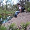
Well, we went to Morrison's Flat and walked down to Drummer's. There is still a lot of water there - 20-30m wide in places, and over a metre deep in many places.
With this amount of water, the usual practice of walking down the middle of the river, and crossing to the inside of bends, was impossible. So we had to walk all the way on the southern side, a much longer walk, and more difficult as the ground is usually very sloping. There are also places where cliffs go down into the water. Sometimes it is possible to go over them, but in one case that was just not on. We ended up climbing over the ridge at a re-entrant and going down the other side. This cut 4km off the trip, which was fortunate as it had been slow going.
For those who are used to seeing the Goulburn with not much water in it....


In this second picture, both channels were flowing quite rapidly and were very deep.
Of course this is not as deep as it has been. There is debris in the trees beside the river from earlier floods that is 10m or more above the current water level.
With this amount of water, the usual practice of walking down the middle of the river, and crossing to the inside of bends, was impossible. So we had to walk all the way on the southern side, a much longer walk, and more difficult as the ground is usually very sloping. There are also places where cliffs go down into the water. Sometimes it is possible to go over them, but in one case that was just not on. We ended up climbing over the ridge at a re-entrant and going down the other side. This cut 4km off the trip, which was fortunate as it had been slow going.
For those who are used to seeing the Goulburn with not much water in it....
In this second picture, both channels were flowing quite rapidly and were very deep.
Of course this is not as deep as it has been. There is debris in the trees beside the river from earlier floods that is 10m or more above the current water level.
This post is copyright by davidmorr. Permission to reproduce elsewhere may be granted on application. Please PM me for details.
- davidmorr
- Athrotaxis cupressoides
- Posts: 448
- Joined: Tue 09 Feb, 2010 11:39 pm
- Location: Newcastle
- Region: New South Wales
- Gender: Male
7 posts
• Page 1 of 1
Return to New South Wales & ACT
Who is online
Users browsing this forum: No registered users and 22 guests