Hi
I'm looking for any information about the above track - has anyone done it or walked sections? Would you recommend it?
I've looked at the official lands department website and its a bit light on detail. I did read that over 50% of the track is on roads or forestry tracks - not too sure about how appealing that would be.
Hume and Hovell Track - anyone done it?
Forum rules
NSW & ACT specific bushwalking discussion. Please avoid publishing details of access to sensitive areas with no tracks.
NSW & ACT specific bushwalking discussion. Please avoid publishing details of access to sensitive areas with no tracks.
20 posts
• Page 1 of 1
Hume and Hovell Track - anyone done it?
![]() by LAMEA-Gals » Thu 08 Dec, 2011 12:28 pm
by LAMEA-Gals » Thu 08 Dec, 2011 12:28 pm
-
LAMEA-Gals - Atherosperma moschatum

- Posts: 86
- Joined: Wed 06 Jan, 2010 2:59 pm
- Region: New South Wales
- Gender: Female
Re: Hume and Hovell Track - anyone done it?
![]() by WarrenH » Fri 09 Dec, 2011 8:52 am
by WarrenH » Fri 09 Dec, 2011 8:52 am
L-G, G'day.
I've done the Hume and Hovell Walking Track taking in parts of the advised cycle route because I could navigate closer to Hume and Hovell's historic route. I did parts of the walking track as recently as two weeks ago. The historic route at Waroo I did last October. The bit of walking track that I did two weeks ago was from the Fitzpatrick Track head towards the Nottingham Hills. I was originally going to ride to Micalong Swamp but I was thwarted by the rain approaching Nottingham Station. I still have the original basic track maps from 20+ years ago, and the slick coloured ones used nowadays. Although it is called a walking track, one can still hike a bike on it ... and hike one will.
Do you realise that the HHWT does't follow Hume and Hovels historic route faithfully in places (?) but we can. With the flooding of the The Murrumbidgee River Valley at Warroo and Taemus, flooding of the Goodradigbee River Valley and Tumut River at Blowering Dam I wonder why it is called the HHWT in places. Between Tumbarumba (Henry Angel Track Head) and the Hume Reservoir (Lake Hume) the walking track has little relationship to Hume and Hovell's actual route, although the track crosses the historic route three times here.
These types of trails should be done the way that they were intended to be done. They are routes for exploration, done over time and what is off the trail is just as important as the trail. Get the maps (if you don't have them already) and then tune the route to where you want to go. Also take in the features like Pompeys Pillar, avoid the pine plantations as much as poss' and check out the world renowned Careys Cave, and leave the trail and climb Jumpers Hill. You'll enjoy a couple of swinging bridges built by Australian Army Engineers ... although one of the low level bridges at Browns Creek requires an alternate route at the moment.
The Hume and Hovell Walking Track isn't just through pristine and prime forests nor beside trackless wilderness (as you have mentioned) but it certainly is in stunningly beautiful country giving the same feel. If you take one step off the track you could be seriously bush bashing. The HHWT matches the BNT for repetitive climbing in wild country and like the BNT you will get to see the working life of rural New South Wales at times. Also, like the BNT the HHWT is I think a pack-horse route, or closer to a multi-purpose trail than just a walking track. The walking tracks are purpose cut and benched. Access to water is a day apart and the highest point on the track is 1100m.
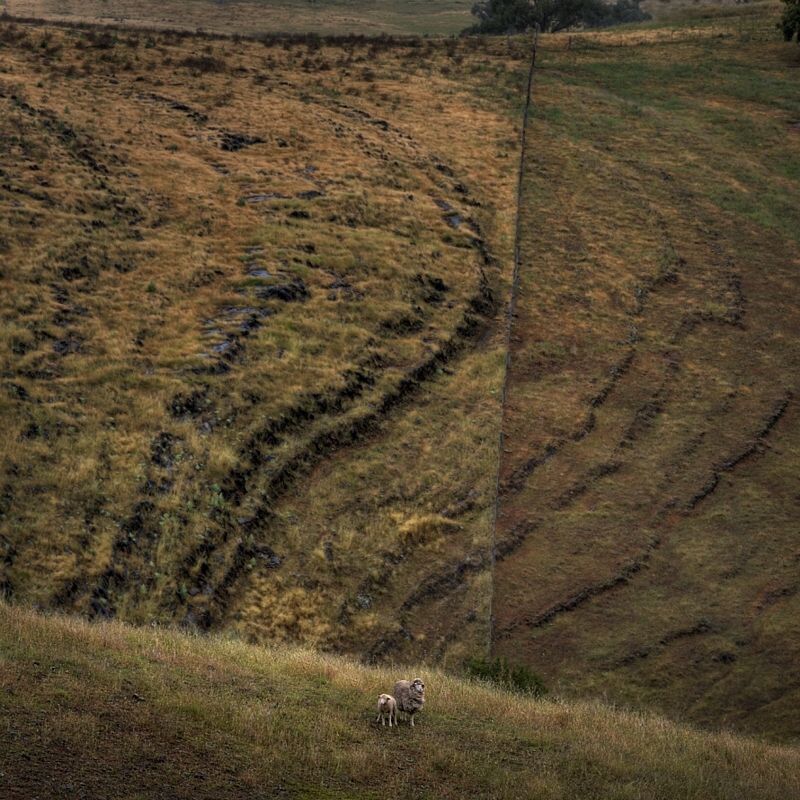
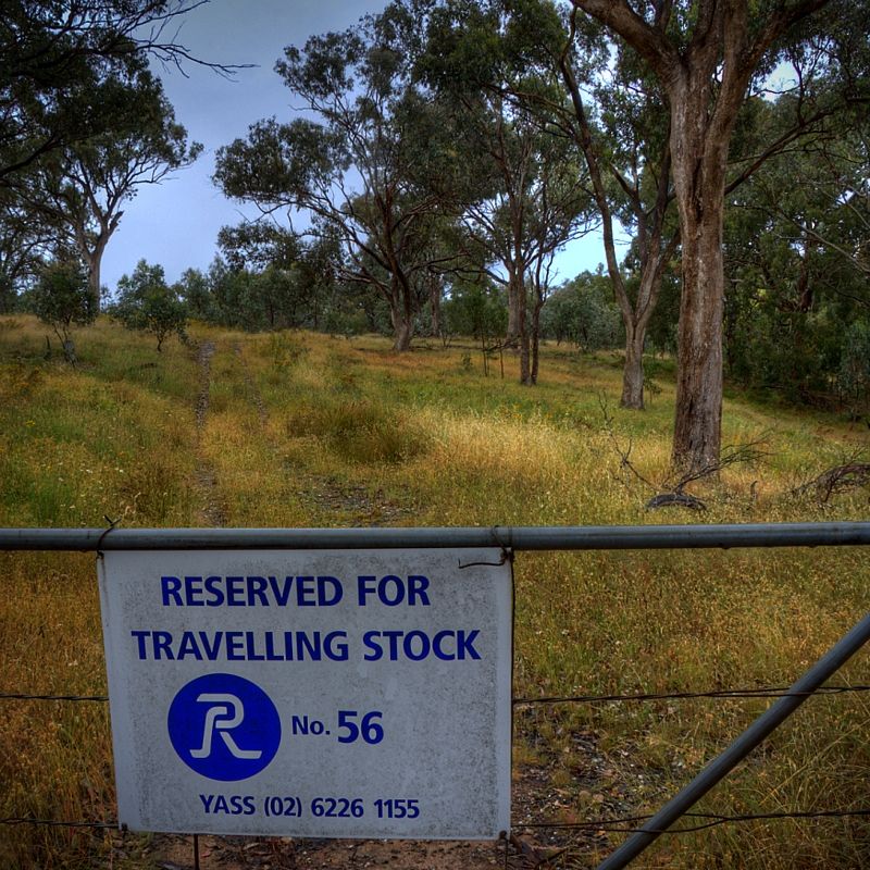
The reason why I did so much of the cycle route was because I could link the Travelling Stock Reserves along the way and at least see the original vegetation that Hume and Hovell would have seen. The TSRs are the original vegetation of Australia and remain relatively undisturbed since European settlement. In the Tumut region at times the pine plantations are on one side of the track while the forests are on the other side, I prefer the bush. This is crazy having plantations on the route and also the route could have been better negotiated with property owners in places, using Crown Land easments. Grazing has had a major impact, there are lots of sheep on the route across the grazing lands.
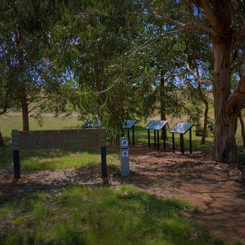
The Track Heads and campsites are a feature of the trail. Many are named after the six convicts that accompanied Hume and Hovell. The Track Heads are well maintained with excellent facilities but not facilities for re-suppling. The campsites have an awning and table and pit toilet. If you avoid the holidays you will certainly enjoy the isolation. In Wee Jasper there is no chance for resupplying, the general store has closed, sadly. Perhaps posting supplies ahead to the Wee Jasper Tavern (open Wednesdays to Sundays if not staying in the accommodation) could be arranged or supplies posted to the National Parks Rangers Station at Billy Grace Reserve. Resupplying from a place like Tumut or other towns requires leaving the trail, especially if travelling South to North posting ahead to Wee Jasper, is the go.
Would I do the Hume and Hovell again, most definitely in early spring through to mid spring. Fewer insects then. In the grazing lands the flies could kidnap you when it is warmer ... and they will.
The old maps are good because they show Hume and Hovell's route where they went up spurs, across ridges and down spurs. When you are in the field you can see where they did go, and at times there are gates on their original route. The new maps show where the cartographer found the quickest way to draw the route and changed the historic route in his or her expediency. In the new map collection is also a description of what happened to the Expedition. Some of the dead ends that thwarted the journey at times are well worth seeing like Micalong Falls and where Burrinjuck Dam is between the peaks of Black Andrew and Barren Jack.
The old maps were for serious walkers, they are very basic. The new maps are well detailed but you will need the topos to show the pine plantations if you want to avoid them ... or identify them on Google Earth.
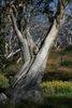
Some images taken on Hume and Hovell's original route going East to West from near where Hume had an outstation not far from Gunning at Lerida Creek (Fish River).
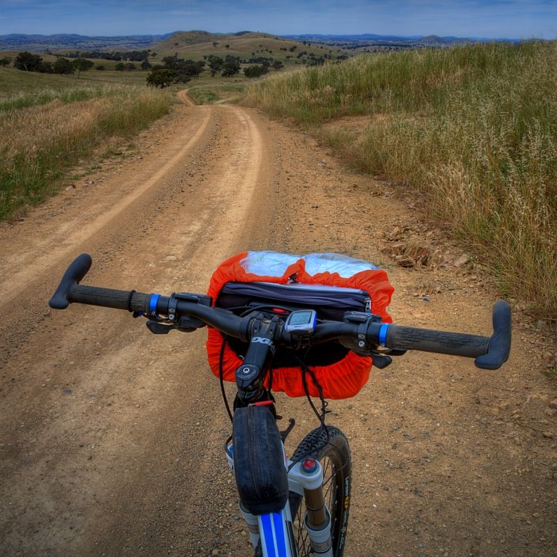
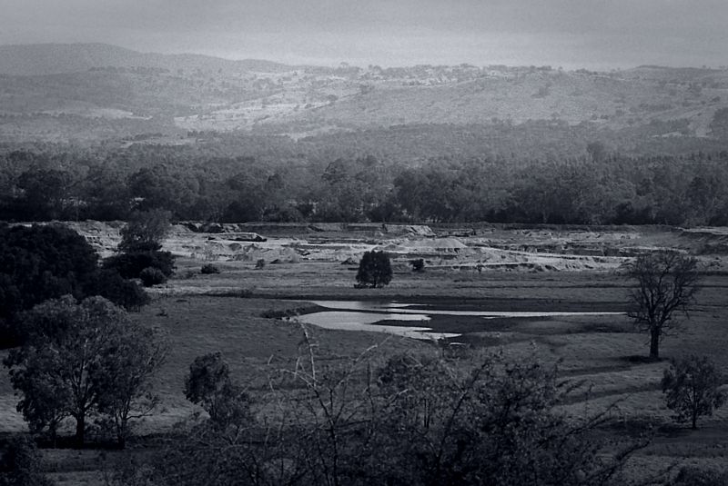
The open grassy woodlands of the Yass Plains east of Warroo. Still showing the effects from 16 years of drought. Fitting because the Expedition suffered hardship during the drought of 1824.
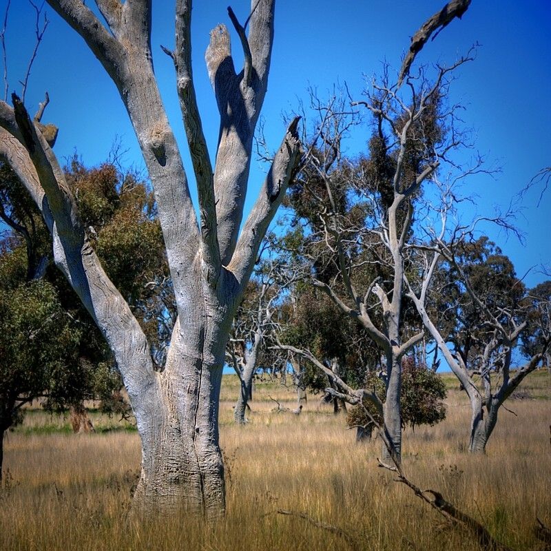
Crossing Warroo Creek. The rotten guard rails are life threatening, but the stone masons' craftsmanship in the bridge below is well worth seeing. Hume and Hovell not far from here (5km further West), turned a wagon into a punt by removing the wheels and sheathing the shell in a tarpaulin and made their first crossing of the Murrumbidgee River.
The anti-clockwise spiralling synclines at Little Plain.
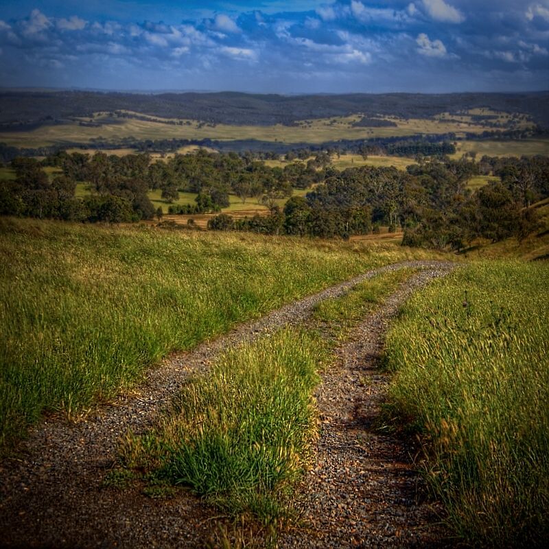
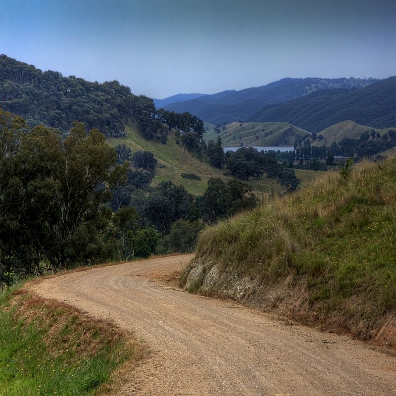
The unformed road at Sutton Creek Travelling Stock Reserve. It was here that Hume and Hovell rested on the 23-24 October 1824. On the 25 October they camped on Sugarloaf Creek. There is also a TSR on Sugarloaf Mountain. If you delve into the history of the expedition, you will find that many things on the trail that go basically go unnoticed are historically significant.
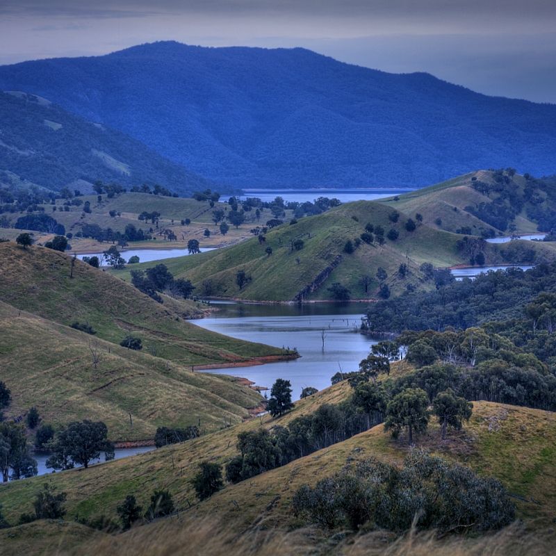
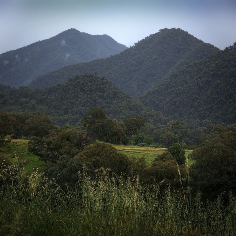
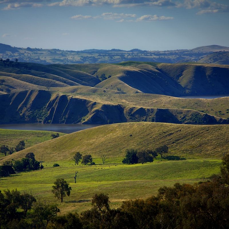
Dropping off Narrangullen Mountain to the Goodradigbee River. Here Hume and Hovell went to the northern end of Goodradigbee Mountain on the right horizon and then returned along the valley towards Wee Jasper.
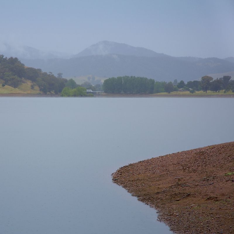
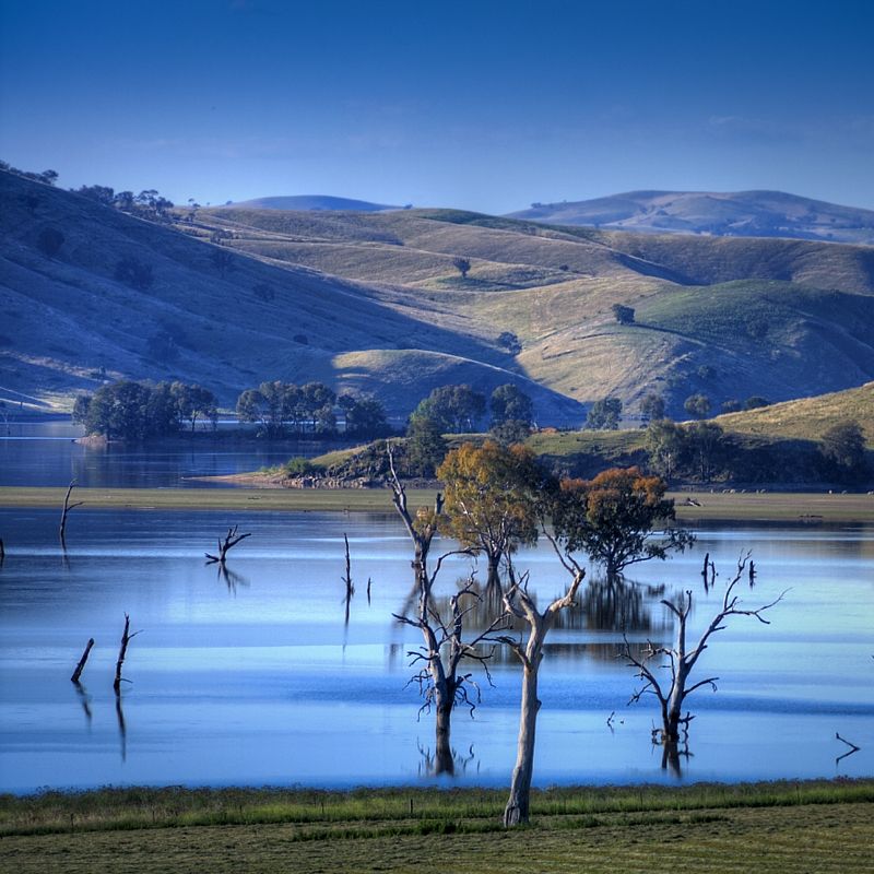
The now flooded Goodradigbee River Valley looking North past Wee Jasper Bridge to Codys Ridge and Codys Range. Photo taken at Carey Reserve. It sure rains a lot nowadays.
The original route across what is now South Wee Jasper Station.
Looking back to the Fitzpatrick Track Head below Goodradigbee Mountain.
You have now finished Hume and Hovell's original route to Wee Jasper Mountain (not the H&H walking track to Fitzpatrick Track Head) shown on the Map #1 Cooma Cottage to Fitzpatrick Track Head.
Three shots from when I finished my 1st trip, on H&H's original route into Albury.
Three White Lights (Albury Flour Mills), Nine Intermediate Egrets,(Hume Reservoir) and Parchment Overshadows(Tunnel Road).
http://wildwassa.deviantart.com/gallery ... 4#/d2v1a8q
http://wildwassa.deviantart.com/gallery ... 2#/d1rhfa6
http://wildwassa.deviantart.com/gallery ... 4#/d2vvg0q
If you want specific details about anywhere on the walking track, let me know. Don't think that you won't go through serious country or enjoy walking along the quiet back country roads. I assure you that you will. Perhaps do a week long walk to see if this type of journeying suits you.
Country link has a bus service to Tumut, Adelong, Wondalga, Batlow, Laurel Hill and Tumbarumba. Perhaps consider doing Fitzpatrick Trackhead to Snowy Mountains Highway (10 km South of Tumut), 78 km. Blowering Campsite to Henry Angel Track Head, 102 km or Tunnel Road to the Hovell Tree in Albury, 73 km. Paddys River Dam to Lankey Creek Campsite, is 90 km.
There is another way to travel on these back country roads, that I prefer, where I might see as many as 2 or 3 cars in a day. Sawyers Gully Road.
Certainly don't think of these quiet back country roads on the HHWT, resemble tourist routes. The busiest road on the route is Black Range Road after leaving Yass, from Yass to Burrinjuck ... if you can call it busy.
Three things to note; Between Lankey Creek and Lake Hume the walking track is closed from 1 December until 28 February because of the high risk of bush fires. The boat service to cross Lake Burrinjuck will not be running until some time in late January or early February 2012. In the map kit there is a stack of info on transportation services and commercial accommodation available. Also the guest houses close to the route, could be good places to post-ahead supplies. For the latest track updates or track closures contact the Track Coordinator Warwick Hull (02) 6937 2700.
Warren.
I've done the Hume and Hovell Walking Track taking in parts of the advised cycle route because I could navigate closer to Hume and Hovell's historic route. I did parts of the walking track as recently as two weeks ago. The historic route at Waroo I did last October. The bit of walking track that I did two weeks ago was from the Fitzpatrick Track head towards the Nottingham Hills. I was originally going to ride to Micalong Swamp but I was thwarted by the rain approaching Nottingham Station. I still have the original basic track maps from 20+ years ago, and the slick coloured ones used nowadays. Although it is called a walking track, one can still hike a bike on it ... and hike one will.
Do you realise that the HHWT does't follow Hume and Hovels historic route faithfully in places (?) but we can. With the flooding of the The Murrumbidgee River Valley at Warroo and Taemus, flooding of the Goodradigbee River Valley and Tumut River at Blowering Dam I wonder why it is called the HHWT in places. Between Tumbarumba (Henry Angel Track Head) and the Hume Reservoir (Lake Hume) the walking track has little relationship to Hume and Hovell's actual route, although the track crosses the historic route three times here.
These types of trails should be done the way that they were intended to be done. They are routes for exploration, done over time and what is off the trail is just as important as the trail. Get the maps (if you don't have them already) and then tune the route to where you want to go. Also take in the features like Pompeys Pillar, avoid the pine plantations as much as poss' and check out the world renowned Careys Cave, and leave the trail and climb Jumpers Hill. You'll enjoy a couple of swinging bridges built by Australian Army Engineers ... although one of the low level bridges at Browns Creek requires an alternate route at the moment.
The Hume and Hovell Walking Track isn't just through pristine and prime forests nor beside trackless wilderness (as you have mentioned) but it certainly is in stunningly beautiful country giving the same feel. If you take one step off the track you could be seriously bush bashing. The HHWT matches the BNT for repetitive climbing in wild country and like the BNT you will get to see the working life of rural New South Wales at times. Also, like the BNT the HHWT is I think a pack-horse route, or closer to a multi-purpose trail than just a walking track. The walking tracks are purpose cut and benched. Access to water is a day apart and the highest point on the track is 1100m.
The reason why I did so much of the cycle route was because I could link the Travelling Stock Reserves along the way and at least see the original vegetation that Hume and Hovell would have seen. The TSRs are the original vegetation of Australia and remain relatively undisturbed since European settlement. In the Tumut region at times the pine plantations are on one side of the track while the forests are on the other side, I prefer the bush. This is crazy having plantations on the route and also the route could have been better negotiated with property owners in places, using Crown Land easments. Grazing has had a major impact, there are lots of sheep on the route across the grazing lands.
The Track Heads and campsites are a feature of the trail. Many are named after the six convicts that accompanied Hume and Hovell. The Track Heads are well maintained with excellent facilities but not facilities for re-suppling. The campsites have an awning and table and pit toilet. If you avoid the holidays you will certainly enjoy the isolation. In Wee Jasper there is no chance for resupplying, the general store has closed, sadly. Perhaps posting supplies ahead to the Wee Jasper Tavern (open Wednesdays to Sundays if not staying in the accommodation) could be arranged or supplies posted to the National Parks Rangers Station at Billy Grace Reserve. Resupplying from a place like Tumut or other towns requires leaving the trail, especially if travelling South to North posting ahead to Wee Jasper, is the go.
Would I do the Hume and Hovell again, most definitely in early spring through to mid spring. Fewer insects then. In the grazing lands the flies could kidnap you when it is warmer ... and they will.
The old maps are good because they show Hume and Hovell's route where they went up spurs, across ridges and down spurs. When you are in the field you can see where they did go, and at times there are gates on their original route. The new maps show where the cartographer found the quickest way to draw the route and changed the historic route in his or her expediency. In the new map collection is also a description of what happened to the Expedition. Some of the dead ends that thwarted the journey at times are well worth seeing like Micalong Falls and where Burrinjuck Dam is between the peaks of Black Andrew and Barren Jack.
The old maps were for serious walkers, they are very basic. The new maps are well detailed but you will need the topos to show the pine plantations if you want to avoid them ... or identify them on Google Earth.
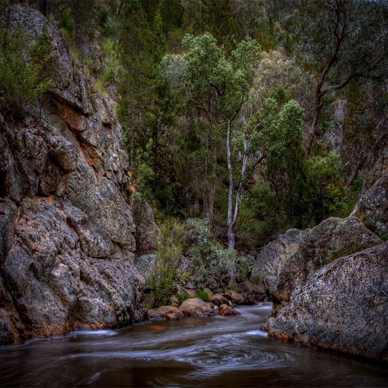
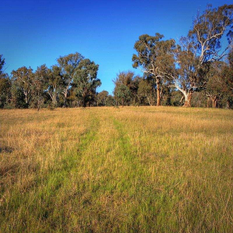
Some images taken on Hume and Hovell's original route going East to West from near where Hume had an outstation not far from Gunning at Lerida Creek (Fish River).
The open grassy woodlands of the Yass Plains east of Warroo. Still showing the effects from 16 years of drought. Fitting because the Expedition suffered hardship during the drought of 1824.
Crossing Warroo Creek. The rotten guard rails are life threatening, but the stone masons' craftsmanship in the bridge below is well worth seeing. Hume and Hovell not far from here (5km further West), turned a wagon into a punt by removing the wheels and sheathing the shell in a tarpaulin and made their first crossing of the Murrumbidgee River.
The anti-clockwise spiralling synclines at Little Plain.
The unformed road at Sutton Creek Travelling Stock Reserve. It was here that Hume and Hovell rested on the 23-24 October 1824. On the 25 October they camped on Sugarloaf Creek. There is also a TSR on Sugarloaf Mountain. If you delve into the history of the expedition, you will find that many things on the trail that go basically go unnoticed are historically significant.
Dropping off Narrangullen Mountain to the Goodradigbee River. Here Hume and Hovell went to the northern end of Goodradigbee Mountain on the right horizon and then returned along the valley towards Wee Jasper.
The now flooded Goodradigbee River Valley looking North past Wee Jasper Bridge to Codys Ridge and Codys Range. Photo taken at Carey Reserve. It sure rains a lot nowadays.
The original route across what is now South Wee Jasper Station.
Looking back to the Fitzpatrick Track Head below Goodradigbee Mountain.
You have now finished Hume and Hovell's original route to Wee Jasper Mountain (not the H&H walking track to Fitzpatrick Track Head) shown on the Map #1 Cooma Cottage to Fitzpatrick Track Head.
Three shots from when I finished my 1st trip, on H&H's original route into Albury.
Three White Lights (Albury Flour Mills), Nine Intermediate Egrets,(Hume Reservoir) and Parchment Overshadows(Tunnel Road).
http://wildwassa.deviantart.com/gallery ... 4#/d2v1a8q
http://wildwassa.deviantart.com/gallery ... 2#/d1rhfa6
http://wildwassa.deviantart.com/gallery ... 4#/d2vvg0q
If you want specific details about anywhere on the walking track, let me know. Don't think that you won't go through serious country or enjoy walking along the quiet back country roads. I assure you that you will. Perhaps do a week long walk to see if this type of journeying suits you.
Country link has a bus service to Tumut, Adelong, Wondalga, Batlow, Laurel Hill and Tumbarumba. Perhaps consider doing Fitzpatrick Trackhead to Snowy Mountains Highway (10 km South of Tumut), 78 km. Blowering Campsite to Henry Angel Track Head, 102 km or Tunnel Road to the Hovell Tree in Albury, 73 km. Paddys River Dam to Lankey Creek Campsite, is 90 km.
There is another way to travel on these back country roads, that I prefer, where I might see as many as 2 or 3 cars in a day. Sawyers Gully Road.
Certainly don't think of these quiet back country roads on the HHWT, resemble tourist routes. The busiest road on the route is Black Range Road after leaving Yass, from Yass to Burrinjuck ... if you can call it busy.
Three things to note; Between Lankey Creek and Lake Hume the walking track is closed from 1 December until 28 February because of the high risk of bush fires. The boat service to cross Lake Burrinjuck will not be running until some time in late January or early February 2012. In the map kit there is a stack of info on transportation services and commercial accommodation available. Also the guest houses close to the route, could be good places to post-ahead supplies. For the latest track updates or track closures contact the Track Coordinator Warwick Hull (02) 6937 2700.
Warren.
Last edited by WarrenH on Wed 14 Dec, 2011 7:38 am, edited 9 times in total.
- WarrenH
- Phyllocladus aspleniifolius

- Posts: 991
- Joined: Thu 07 Jan, 2010 6:54 pm
- Region: Australian Capital Territory
Re: Hume and Hovell Track - anyone done it?
![]() by WarrenH » Sat 10 Dec, 2011 6:44 pm
by WarrenH » Sat 10 Dec, 2011 6:44 pm
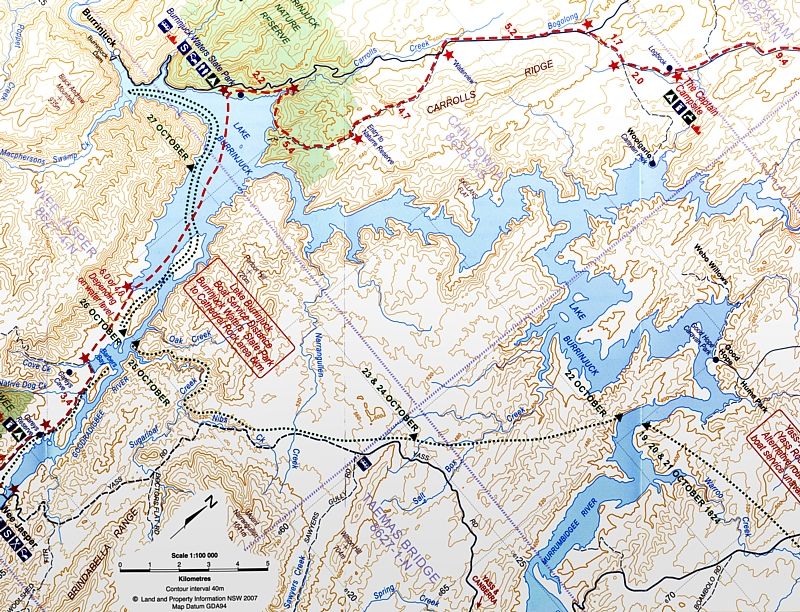
This is a section of Map #1 where the images were taken, although the first shot on the Cullarin Range is 50 km further East.
The red route is the walking track the green route the historic route.
Warren.
The red route is the walking track the green route the historic route.
Warren.
- WarrenH
- Phyllocladus aspleniifolius
- Posts: 991
- Joined: Thu 07 Jan, 2010 6:54 pm
- Region: Australian Capital Territory
Re: Hume and Hovell Track - anyone done it?
![]() by Dazza45 » Sat 10 Dec, 2011 7:17 pm
by Dazza45 » Sat 10 Dec, 2011 7:17 pm
Hi L-G
A good resource is the Hume & Hovell Walking Track Guidebook by Harry Hill and published by Crawford House Press. Harry is an old timer who lives in Tumut and has spent a life time walking through the area and was involved in the development of the track. The track is basically in our backyard and we have done several parts of it mainly as day walks. If you are choosey you can pick out the parts that keep away from main roads however as some parts go through State forests so you can't avoid some fire trails.
A good resource is the Hume & Hovell Walking Track Guidebook by Harry Hill and published by Crawford House Press. Harry is an old timer who lives in Tumut and has spent a life time walking through the area and was involved in the development of the track. The track is basically in our backyard and we have done several parts of it mainly as day walks. If you are choosey you can pick out the parts that keep away from main roads however as some parts go through State forests so you can't avoid some fire trails.
I intend to live forever - so far, so good!
- Dazza45
- Nothofagus gunnii

- Posts: 17
- Joined: Sun 06 Sep, 2009 5:27 pm
- Location: Batlow NSW
- Region: New South Wales
- Gender: Male
Re: Hume and Hovell Track - anyone done it?
![]() by LAMEA-Gals » Sun 11 Dec, 2011 10:45 am
by LAMEA-Gals » Sun 11 Dec, 2011 10:45 am
Thanks Warren for your detailed response - this is why these forums are so useful!
Certainly has made me look at the track differently. Also has given me ideas about how to approach the trip to get the most from it - I didn't realise how much it was away from the H&H original route - but I also now appreciate that its not on busy rural roads with lots of sealed road walking. The photos were really good too. My original intention was to do the whole lot in one go - walking it in late autumn/early winter. Spending about 3 weeks with a couple of rest days added.
I now want to do some more research - I'll get the official map kit from the Lands Dept and possibly the book that Dazza was referring too. I have more questions mostly about food drops, navigation and if my timeframe is reasonable (too short, too long - I'm an average walker not doing ultra marathon times). Perhaps after I have done some more research I can contact you with any issues that I can't work out from the information. Thanks again.
-
LAMEA-Gals - Atherosperma moschatum
- Posts: 86
- Joined: Wed 06 Jan, 2010 2:59 pm
- Region: New South Wales
- Gender: Female
Re: Hume and Hovell Track - anyone done it?
![]() by WarrenH » Sun 11 Dec, 2011 1:20 pm
by WarrenH » Sun 11 Dec, 2011 1:20 pm
L-G, you are most welcome. When you stand on Wee Jasper Mountains looking across the Bogong Ranges Wilderness and the Bimberi Wilderness ... I bet you'll say WOW!!
I have more than 1,000 photographs from my Ist trip that I've had the b/w negatives processed and contact printed but not yet really looked at (by me). I crossed farms and spent time with graziers and cowboys and Landcare Groups ... http://wildwassa.deviantart.com/art/I-W ... -106390312
I sat on the outside on the front of trains at times photographing where the historic route is now railway lines. It took me months to organise the first trip, courtesy of the National Library of Australia. The way the first trip was organised might be impossible to organise nowadays. Someone at Albury Station delayed a train while I walked across the railway bridge over the river and took photos. Certainly not sitting on the outside of trains taking photos of the route would be allowed nowadays, I presume. At the time the different rail gauges had only been standardised between the states, which added another historic twist.
The National Library of Australia has a digital map collection where you can find some historic maps including Hume's hand drawn sketch maps (below). Hume wasn't the navigator on the trip, he was the expert bushman who kept the guys and the stock alive. Hovell was the main mapmaker with sextant and perambulator. The Mitchell Library collection has an expedition map called ... Map shewing "Journey of Discovery" of Hume and Hovell from near Lake George to crossing of the Hume, N.S.W.-1824 [cartographic material] / compiled, drawn and printed at the Dept. of Lands. Shewing is the correct word and this map was produced in 1934.
There is also the classic work, that can be found in the State Library and local libraries, Hume and Hovell Expedition (1824) Edited by Alan E.J. Andrews. Published, Hobart : Blubber Head Press, 1981. ISBN 0908528078. Dewey 919.4/042 Description 389 p., [12] p. of plates : ill., facsim., maps ; 22 cm.
This is the first page of Hume's sketch maps and has part of the second page. From the National Library of Australia, Digital Map Collection called ... Mr Hume's sketch of a tour performed by W.H. Hovell and himself from Lake George to Port Phillip, Bass's Straits . Port Phillip is where they thought that they reached but they actually made the coast at Corio Bay.
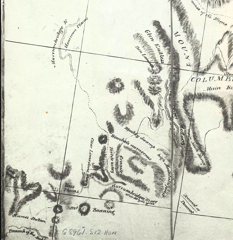
The journey was from bottom left to top right. You will notice that there are also very faint lines not just the heavier line of the route. The faint lines were their side trips and where the landscape thwarted them they turned back and they split the group a few times when the Expedition Leaders fell out with each other over the route. Hume liked the hill climbs heading south while Hovell wanted the flatter going out west.
Some features of the sketch map. By 1824 no European had been further west than Hume's Oustation east of the Cullerin Range/Lerida Creek. The Medway River is the Gooberagandra River that joins the Tumut River (Toomat or Doomat), the Hume River (top right) is now called the mighty Murray River. Muddy Swamp is Micalong Swamp. Here where the route splits, the high route was the outward route and the lower the return journey. The ranges of Mount Colombus are the Bogong Mountains rising to over 1700m in the Bogong Peaks in the south of the range. The Leaders mistakenly thought that the Goodradigbee was an extension of the Murrumbidgee in 'Fertile Valley'. Granite is Mount Wee Jasper and Goodradigbee Mountain. Not bad when the only map that they took with them showed the coastlines of NSW and Victoria ... and the rest of the map was a blank sheet.
Under the W of 'Wombats Numerous' there is a faint line. This is where Micalong Creek turned them around and they had to go back to what is now Fitzpatrick Track Head and go over Wee Jasper Mountain.
Where there is a Travelling Stock Route or Reserve on or beside either route, the historic route or the walking track you are able to camp on the TSRs for free. You need to ring the Livestock Health and Pest Authority Regional Office and notify the LHPA Ranger that you would like to use the TSR ... http://www.lhpa.org.au/contact. I usually ring before hand so that I don't wake up surrounded by 1,000 sheep or cows that get unloaded during the night.
The TSRs are a gift to long distance travellers. I'm a real fan of the TSRs. When you get on a TSR, follow the unformed road from the gate, which will take you to the campsite and/or watering points. Some TSR campsites have been used for over 160 years by drovers and shepherds. The campsites are always first class.
There is plenty of grub in the dams on the TSRs. TSRs are Crown Land. If you like to fish or catch yabbies, you'll need a NSW Recreational Inland Fishing Licence. ... $30 for a year, if you don't already.
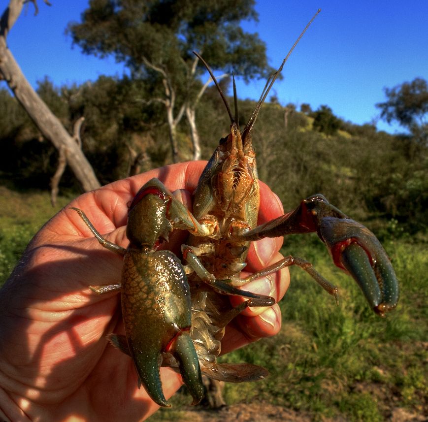
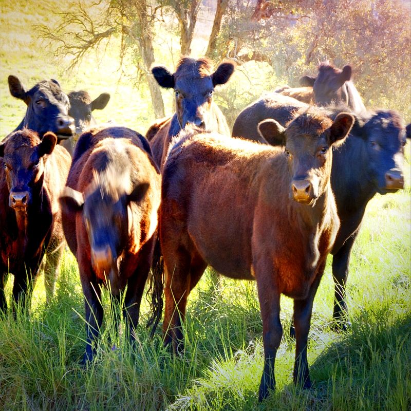
In October I was heading to Warroo Bridge. I was on the Murrumbidgee River not far from Cavan Station and along came some crazy fan boys.

Just a few of the local lads that you will meet on the Hume and Hovell.
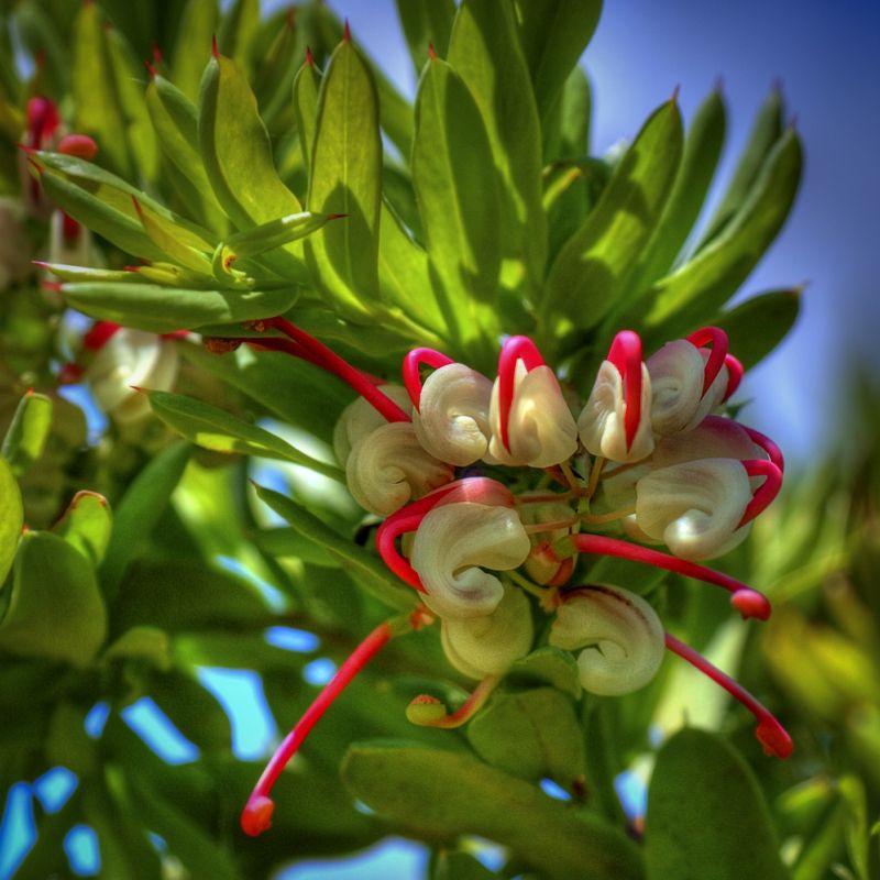
The flowers are nice too, on the trail. The critically endangered Wee Jasper Spider Flower Grevillea iaspiculata that is said to now have only 150 mature plants still in the wild.
The potential for a life changing experience ... is certainly there. Have a good trip.
Warren.
I have more than 1,000 photographs from my Ist trip that I've had the b/w negatives processed and contact printed but not yet really looked at (by me). I crossed farms and spent time with graziers and cowboys and Landcare Groups ... http://wildwassa.deviantart.com/art/I-W ... -106390312
I sat on the outside on the front of trains at times photographing where the historic route is now railway lines. It took me months to organise the first trip, courtesy of the National Library of Australia. The way the first trip was organised might be impossible to organise nowadays. Someone at Albury Station delayed a train while I walked across the railway bridge over the river and took photos. Certainly not sitting on the outside of trains taking photos of the route would be allowed nowadays, I presume. At the time the different rail gauges had only been standardised between the states, which added another historic twist.
The National Library of Australia has a digital map collection where you can find some historic maps including Hume's hand drawn sketch maps (below). Hume wasn't the navigator on the trip, he was the expert bushman who kept the guys and the stock alive. Hovell was the main mapmaker with sextant and perambulator. The Mitchell Library collection has an expedition map called ... Map shewing "Journey of Discovery" of Hume and Hovell from near Lake George to crossing of the Hume, N.S.W.-1824 [cartographic material] / compiled, drawn and printed at the Dept. of Lands. Shewing is the correct word and this map was produced in 1934.
There is also the classic work, that can be found in the State Library and local libraries, Hume and Hovell Expedition (1824) Edited by Alan E.J. Andrews. Published, Hobart : Blubber Head Press, 1981. ISBN 0908528078. Dewey 919.4/042 Description 389 p., [12] p. of plates : ill., facsim., maps ; 22 cm.
This is the first page of Hume's sketch maps and has part of the second page. From the National Library of Australia, Digital Map Collection called ... Mr Hume's sketch of a tour performed by W.H. Hovell and himself from Lake George to Port Phillip, Bass's Straits . Port Phillip is where they thought that they reached but they actually made the coast at Corio Bay.
The journey was from bottom left to top right. You will notice that there are also very faint lines not just the heavier line of the route. The faint lines were their side trips and where the landscape thwarted them they turned back and they split the group a few times when the Expedition Leaders fell out with each other over the route. Hume liked the hill climbs heading south while Hovell wanted the flatter going out west.
Some features of the sketch map. By 1824 no European had been further west than Hume's Oustation east of the Cullerin Range/Lerida Creek. The Medway River is the Gooberagandra River that joins the Tumut River (Toomat or Doomat), the Hume River (top right) is now called the mighty Murray River. Muddy Swamp is Micalong Swamp. Here where the route splits, the high route was the outward route and the lower the return journey. The ranges of Mount Colombus are the Bogong Mountains rising to over 1700m in the Bogong Peaks in the south of the range. The Leaders mistakenly thought that the Goodradigbee was an extension of the Murrumbidgee in 'Fertile Valley'. Granite is Mount Wee Jasper and Goodradigbee Mountain. Not bad when the only map that they took with them showed the coastlines of NSW and Victoria ... and the rest of the map was a blank sheet.
Under the W of 'Wombats Numerous' there is a faint line. This is where Micalong Creek turned them around and they had to go back to what is now Fitzpatrick Track Head and go over Wee Jasper Mountain.
Where there is a Travelling Stock Route or Reserve on or beside either route, the historic route or the walking track you are able to camp on the TSRs for free. You need to ring the Livestock Health and Pest Authority Regional Office and notify the LHPA Ranger that you would like to use the TSR ... http://www.lhpa.org.au/contact. I usually ring before hand so that I don't wake up surrounded by 1,000 sheep or cows that get unloaded during the night.
The TSRs are a gift to long distance travellers. I'm a real fan of the TSRs. When you get on a TSR, follow the unformed road from the gate, which will take you to the campsite and/or watering points. Some TSR campsites have been used for over 160 years by drovers and shepherds. The campsites are always first class.
There is plenty of grub in the dams on the TSRs. TSRs are Crown Land. If you like to fish or catch yabbies, you'll need a NSW Recreational Inland Fishing Licence. ... $30 for a year, if you don't already.
In October I was heading to Warroo Bridge. I was on the Murrumbidgee River not far from Cavan Station and along came some crazy fan boys.
Just a few of the local lads that you will meet on the Hume and Hovell.
The flowers are nice too, on the trail. The critically endangered Wee Jasper Spider Flower Grevillea iaspiculata that is said to now have only 150 mature plants still in the wild.
The potential for a life changing experience ... is certainly there. Have a good trip.
Warren.
Last edited by WarrenH on Thu 15 Dec, 2011 11:29 am, edited 2 times in total.
- WarrenH
- Phyllocladus aspleniifolius
- Posts: 991
- Joined: Thu 07 Jan, 2010 6:54 pm
- Region: Australian Capital Territory
Re: Hume and Hovell Track - anyone done it?
![]() by WarrenH » Thu 15 Dec, 2011 9:19 am
by WarrenH » Thu 15 Dec, 2011 9:19 am
L-G, a painting by George Edwards Peacock, to give an edge towards your consideration of a possible trip.
'The South Australian Alps as first seen by Messrs. Hume and Hovell on the 8th November 1824'. Painting courtesy of the Mitchell Library, State Library of NSW, and it was stolen for educational purposes. The date of the painting is not accurately known, but was done post 1836.
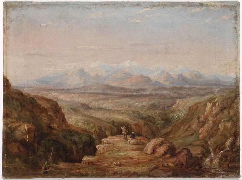
This painting shows the location on the track near where Burra Creek joins Tumbarumba Creek, about 5km south of Henry Angel Trackhead and campsite. The slope on the left is Big Hill. There is a logbook here and a track towards the summit of Big Hill that Hume and Hovell scouted. As you descend Burra Creek, along the track there are three drops of falls. Here the track is faithful to the original route, for 15 kilometres east of Tumbarumba township. There was an unnamed Aboriginal bloke on the trip too, an interpreter, but he rarely features in the writings nor in the art (in the paintings and woodcuts that I've seen). He was undoubtedly the one who scouted ahead and warned off the locals.
The South Australian Alps was the name given by Hume and Hovell to the now Australian Alps ... that's when the first Australian Alps, were the mountains around Morton Bay in Queensland. In the State Library catalogue, details incorrectly, this painting as a landscape from South Australia.
This is the account from Hovell's journal.
"We were suddenly surprised by a sight to the utmost degree magnificent. Mountains of a conical form and of apparently immense height and some of them covered about one-fourth their height with snow, were now seen extending semi-circularly from the south-east to the south-west, at the supposed distance of about 20 miles.
The sun was bright and gave them an appearance the most brilliant. The men had no sooner heard of this unexpected and interesting scene than, catching the enthusiasm, they ran to the spot, and were not less surprised and delighted at this pre-eminently grand and beautiful spectacle."
Warren.
'The South Australian Alps as first seen by Messrs. Hume and Hovell on the 8th November 1824'. Painting courtesy of the Mitchell Library, State Library of NSW, and it was stolen for educational purposes. The date of the painting is not accurately known, but was done post 1836.
This painting shows the location on the track near where Burra Creek joins Tumbarumba Creek, about 5km south of Henry Angel Trackhead and campsite. The slope on the left is Big Hill. There is a logbook here and a track towards the summit of Big Hill that Hume and Hovell scouted. As you descend Burra Creek, along the track there are three drops of falls. Here the track is faithful to the original route, for 15 kilometres east of Tumbarumba township. There was an unnamed Aboriginal bloke on the trip too, an interpreter, but he rarely features in the writings nor in the art (in the paintings and woodcuts that I've seen). He was undoubtedly the one who scouted ahead and warned off the locals.
The South Australian Alps was the name given by Hume and Hovell to the now Australian Alps ... that's when the first Australian Alps, were the mountains around Morton Bay in Queensland. In the State Library catalogue, details incorrectly, this painting as a landscape from South Australia.
This is the account from Hovell's journal.
"We were suddenly surprised by a sight to the utmost degree magnificent. Mountains of a conical form and of apparently immense height and some of them covered about one-fourth their height with snow, were now seen extending semi-circularly from the south-east to the south-west, at the supposed distance of about 20 miles.
The sun was bright and gave them an appearance the most brilliant. The men had no sooner heard of this unexpected and interesting scene than, catching the enthusiasm, they ran to the spot, and were not less surprised and delighted at this pre-eminently grand and beautiful spectacle."
Warren.
- WarrenH
- Phyllocladus aspleniifolius
- Posts: 991
- Joined: Thu 07 Jan, 2010 6:54 pm
- Region: Australian Capital Territory
Re: Hume and Hovell Track - anyone done it?
![]() by WarrenH » Tue 20 Dec, 2011 2:50 am
by WarrenH » Tue 20 Dec, 2011 2:50 am
Yesterday I spent a bit of time going over my HHWT images. Here are a couple of old shots, taken during the first year that the track was opened. A year when the Murray River was extremely low and the extensive network of "lagoons," had all but disappeared.
The Hovell Tree.
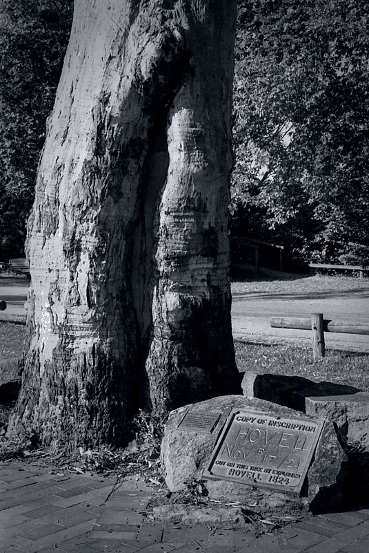
The almost dry Murray River and lagoons. This shot should remind farmers with short memories how important the proposed Murray-Darling Water Policy will be for this nation. When Hume and Hovell crossed the "Hume River" (now called the Murray), they took several days to find a suitable place to cross because of the wide "lagoons" each side of the river and because the river was 10-12 ft deep, 80 yards broad, the banks 8-10 ft high and it was flowing at 2-3 knots ... and that was also during a drought. The word billabong wasn't used then, for the Hume's "lagoons," back in 1824.
Warren.
The Hovell Tree.
The almost dry Murray River and lagoons. This shot should remind farmers with short memories how important the proposed Murray-Darling Water Policy will be for this nation. When Hume and Hovell crossed the "Hume River" (now called the Murray), they took several days to find a suitable place to cross because of the wide "lagoons" each side of the river and because the river was 10-12 ft deep, 80 yards broad, the banks 8-10 ft high and it was flowing at 2-3 knots ... and that was also during a drought. The word billabong wasn't used then, for the Hume's "lagoons," back in 1824.
Warren.
- WarrenH
- Phyllocladus aspleniifolius
- Posts: 991
- Joined: Thu 07 Jan, 2010 6:54 pm
- Region: Australian Capital Territory
Re: Hume and Hovell Track - anyone done it?
![]() by PiniPowPow » Wed 21 Dec, 2011 7:20 am
by PiniPowPow » Wed 21 Dec, 2011 7:20 am
Thanks Warren, I have really enjoyed reading your posts on this topic. Inspiring stuff, would love to check out the track at some stage.
- PiniPowPow
- Atherosperma moschatum
- Posts: 81
- Joined: Thu 09 Jun, 2011 6:46 pm
- Location: Jindabyne
- Region: New South Wales
- Gender: Male
Re: Hume and Hovell Track - anyone done it?
![]() by ma63rk » Mon 02 Jan, 2012 4:36 pm
by ma63rk » Mon 02 Jan, 2012 4:36 pm
As a descendant of one of Hume's "men" on the original 1824 trek, I'd like to make an attempt at some, if not all, of this walk.
Just got to stop "life" for a few weeks so some plans can be made.
Just got to stop "life" for a few weeks so some plans can be made.
- ma63rk
- Nothofagus cunninghamii

- Posts: 1
- Joined: Mon 02 Jan, 2012 4:28 pm
- Location: Sydney
- Region: New South Wales
- Gender: Male
Re: Hume and Hovell Track - anyone done it?
![]() by WarrenH » Tue 03 Jan, 2012 3:02 am
by WarrenH » Tue 03 Jan, 2012 3:02 am
PiniPowPow, Cheers Mate.
From the Yass Plains to Albury is half the story or actually only a quarter of their journey. If you're interested you can download a high-resolution image for the Victorian legs out and back, courtesy of the State Library of Victoria. Click on the small image, then follow the instructions for a high-res image ... http://catalogue.slv.vic.gov.au/vwebv/h ... bId=672820
You can also see this map on the State Library of New South Wales' website, as well as an early hand drawn map of the route.
http://www.sl.nsw.gov.au/discover_colle ... /maps.html
ma63rk, a few more shots following Hamilton Hume, William Hovell, James Fitzpatrick, Thomas Boyd, Claude Bossawa, William Bollard, Henry Angel and Thomas Smith's, original route on Map #1. The aboriginal bloke, I cant include his name. I've not seen his name mentioned, not once in the journals, in the accounts or in the statements of facts, sadly.
Next three images are on H&H's original route in Map #I.
The steep basin in shadow on the right is 'The Hawks Nest', This is where the party made their first crossing of the Murrumbidgee, when the river was in flood. They turned the cart into a punt ... and left their two carts here. In the centre of the photo is a classic anticline in the Devonian limestone called 'The Sharks Mouth'. This spectacular bit of earth is called Majurgong. The HHWT is on the far skyline, on Carrols Ridge.
The path to Little Plain was along the spine of Majurgong, now part of the Old Taemus Road. This is the flood plain of Mountain Creek at the confluence with the Murrumbidgee, now well inundated. There is a lot of water around at the moment. During the previous decade and a half, this was dry ground and you could step across Mountain Creek.
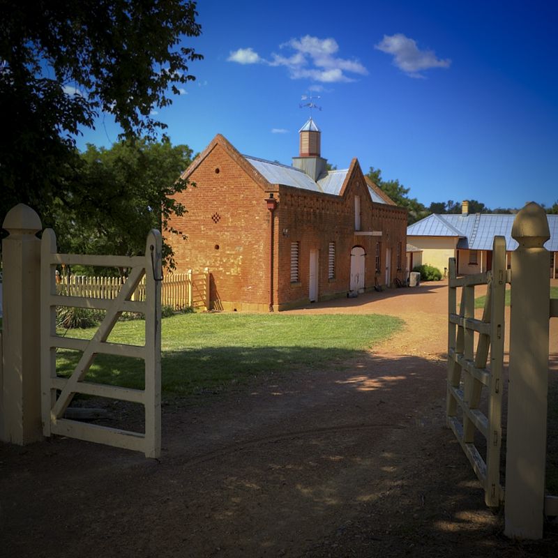
Two shots from Hume's home 'Cooma Cottage' and the Yass track head that starts at the cottage. The stables and the rare Palo Blanco Tree, Picconia excelsa, from the Canary Islands. Planted sometime around 1830 to 1840.
From a side trip to Hume's grave in the Anglican Section of the Yass Cemetery.
Warren.
From the Yass Plains to Albury is half the story or actually only a quarter of their journey. If you're interested you can download a high-resolution image for the Victorian legs out and back, courtesy of the State Library of Victoria. Click on the small image, then follow the instructions for a high-res image ... http://catalogue.slv.vic.gov.au/vwebv/h ... bId=672820
You can also see this map on the State Library of New South Wales' website, as well as an early hand drawn map of the route.
http://www.sl.nsw.gov.au/discover_colle ... /maps.html
ma63rk, a few more shots following Hamilton Hume, William Hovell, James Fitzpatrick, Thomas Boyd, Claude Bossawa, William Bollard, Henry Angel and Thomas Smith's, original route on Map #1. The aboriginal bloke, I cant include his name. I've not seen his name mentioned, not once in the journals, in the accounts or in the statements of facts, sadly.
Next three images are on H&H's original route in Map #I.
The steep basin in shadow on the right is 'The Hawks Nest', This is where the party made their first crossing of the Murrumbidgee, when the river was in flood. They turned the cart into a punt ... and left their two carts here. In the centre of the photo is a classic anticline in the Devonian limestone called 'The Sharks Mouth'. This spectacular bit of earth is called Majurgong. The HHWT is on the far skyline, on Carrols Ridge.
The path to Little Plain was along the spine of Majurgong, now part of the Old Taemus Road. This is the flood plain of Mountain Creek at the confluence with the Murrumbidgee, now well inundated. There is a lot of water around at the moment. During the previous decade and a half, this was dry ground and you could step across Mountain Creek.
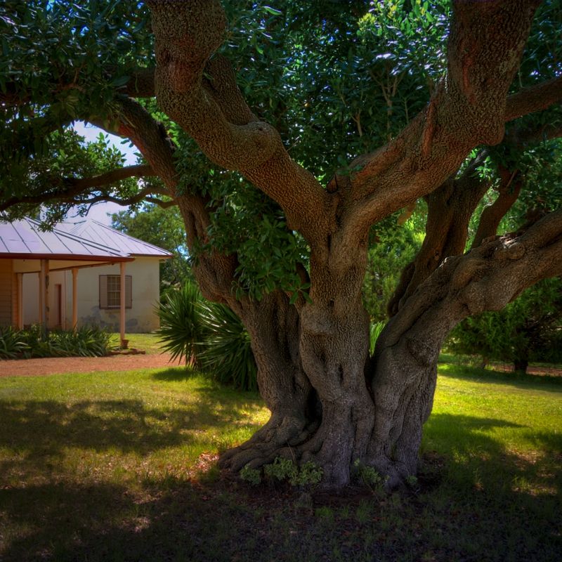
Two shots from Hume's home 'Cooma Cottage' and the Yass track head that starts at the cottage. The stables and the rare Palo Blanco Tree, Picconia excelsa, from the Canary Islands. Planted sometime around 1830 to 1840.
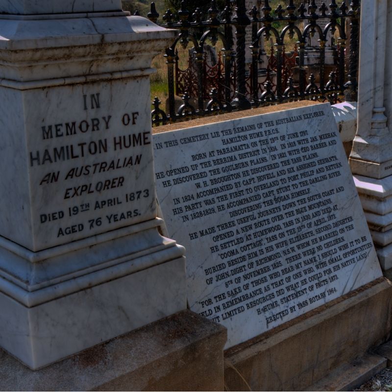
From a side trip to Hume's grave in the Anglican Section of the Yass Cemetery.
Warren.
- WarrenH
- Phyllocladus aspleniifolius
- Posts: 991
- Joined: Thu 07 Jan, 2010 6:54 pm
- Region: Australian Capital Territory
Re: Hume and Hovell Track - anyone done it?
![]() by WarrenH » Sun 19 Feb, 2012 8:09 pm
by WarrenH » Sun 19 Feb, 2012 8:09 pm
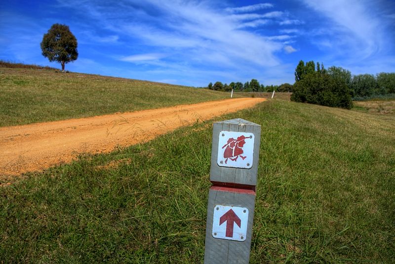
Suspicious looking individuals please go this way.
Warren.
Warren.
- WarrenH
- Phyllocladus aspleniifolius
- Posts: 991
- Joined: Thu 07 Jan, 2010 6:54 pm
- Region: Australian Capital Territory
Re: Hume and Hovell Track - anyone done it?
![]() by Lindsay » Mon 20 Feb, 2012 11:46 pm
by Lindsay » Mon 20 Feb, 2012 11:46 pm
That's a strange symbol to indicate a walking track. Looks more like an invite to hang around outside a school and offer boiled lollies......
-

Lindsay - Phyllocladus aspleniifolius
- Posts: 679
- Joined: Thu 01 Oct, 2009 3:00 pm
- Location: Sydney
- Region: New South Wales
- Gender: Male
Re: Hume and Hovell Track - anyone done it?
![]() by Strick » Wed 25 Apr, 2012 12:23 am
by Strick » Wed 25 Apr, 2012 12:23 am
So Spring and Autumn are the ideal times to be walking the track?
Am I right in my impression that, although the trail passes through some high country, it mostly avoids high level routes, so it is unlikely you will be caught out in a blizzard whatever time of the year you choose?
I have played around with the idea of bushwalking the HHT for years, but might have an opportunity this September. Fantastic photos Warren H.
- Strick
- Nothofagus gunnii
- Posts: 24
- Joined: Mon 16 Apr, 2012 8:51 am
- Location: Hobart
- Region: Tasmania
- Gender: Male
Re: Hume and Hovell Track - anyone done it?
![]() by DaveM » Fri 18 May, 2012 2:55 pm
by DaveM » Fri 18 May, 2012 2:55 pm
I did a fair chunk of it too many years ago. (Late 80's or early 90's)
4 of us walked from Wee Jasper to Henry Angel Flat (Near Tumbarumba). Not all of it is spectacular, yes you can spend some time on fire trails and in Pine Forest etc but overall we loved it. Some of the views ARE spectacular.
We walked it in July, got some good snow between Buddong & Paddys River Dam, (had the best snow fight EVER when the snow stopped, cloud instantly disappeared and we were now under a full moon with incredible amounts of light) plenty of icy nights but we were equipped for it and had a ball most of the time.
We did get quite wet the first day on the first big climb, managed to destroy a few things trying to dry them out - eg one melted heel on a Hi Tec boot, made for a strange walking gait the rest of the trip. Someone tried to dry out a mat with the valve still tight - delaminated it plus heaps of other dumb things we now laugh at.
A ranger found us when camping on the Goobragandra - he was so surprised to find people walking it in July he handed out a few beers for us (just came from Tumut with a new carton) - thank you very much.
The views around Buddong back to Talbingo Mt etc are awesome.
Do it and do it in the cooler months for even more atmosphere. One of the best walks I've ever done - it was my first walk longer than a weekend.
- DaveM
- Nothofagus gunnii
- Posts: 14
- Joined: Wed 20 Jul, 2011 2:13 pm
- Region: New South Wales
- Gender: Male
Re: Hume and Hovell Track - anyone done it?
![]() by xbgs351 » Thu 14 Jun, 2012 10:13 am
by xbgs351 » Thu 14 Jun, 2012 10:13 am
WarrenH wrote:L-G, G'day.
I've done the Hume and Hovell Walking Track taking in parts of the advised cycle route because I could navigate closer to Hume and Hovell's historic route. I did parts of the walking track as recently as two weeks ago. The historic route at Waroo I did last October. The bit of walking track that I did two weeks ago was from the Fitzpatrick Track head towards the Nottingham Hills. I was originally going to ride to Micalong Swamp but I was thwarted by the rain approaching Nottingham Station. I still have the original basic track maps from 20+ years ago, and the slick coloured ones used nowadays. Although it is called a walking track, one can still hike a bike on it ... and hike one will.
Warren.
Hi Waren,
Where did you obtain the advised cycle route? Does it come as part of the LMPA map kit?
Cheers,
Rohan
- xbgs351
- Nothofagus cunninghamii
- Posts: 1
- Joined: Thu 14 Jun, 2012 9:31 am
- Region: Australia
- Gender: Male
Re: Hume and Hovell Track - anyone done it?
![]() by JohnDaly TakeAWalk » Fri 27 Jul, 2012 3:59 pm
by JohnDaly TakeAWalk » Fri 27 Jul, 2012 3:59 pm
Hi Guys
We have just printed our latest book - Take A Walk in Southern NSW & the ACT. It has a whole heap of overnight walks, including the complete Hume and Hovell Walking Track. We will get the stock next week!
We reckon it's one of the most under rated walks in Australia
Check it out at www.takeawalk.com.au
Within a few days we'll be announcing a competition where everyone who buys a copy will go into a draw to win a paid of Scarpa boots.
Cheers
John
- JohnDaly TakeAWalk
- Nothofagus gunnii
- Posts: 41
- Joined: Sat 16 Apr, 2011 7:55 am
- Region: Queensland
Re: Hume and Hovell Track - anyone done it?
![]() by WarrenH » Tue 31 Jul, 2012 10:59 am
by WarrenH » Tue 31 Jul, 2012 10:59 am
xbgs351 wrote:Where did you obtain the advised cycle route? Does it come as part of the LMPA map kit?
Rohan G'day.
No doubt you will have seen this info on the LHPA thread about the HHWT in 'Frequently Asked Questions.'
Can I ride my mountain bike on the walking track?
The Hume and Hovell Walking Track may be used by mountain bikes where the track uses Public or Crown roads or fire trails. Where the track uses ‘single track’ or specially constructed walking track, bikes must be pushed or carried. A popular section for mountain bikes is between Lankeys Creek Campsite and Tunnel Road (see Sectional Map 5). This section is located on a ridge fire trail within Woomargama National Park.
If you have the map kit you will see what roads and firetrails are closest to both the walking track and Hume and Hovell's original route. Then tune the ride to your capabilities and for the time that you have allowed. I approached graziers for permission to cross their properties using farm tracks. I find that getting permission to cross properties can take a long time, often due to absent landholders. Almost always, they will give permission for bike-packers to cross properties and to camp on their properties, when you say that you're on a pushbike, not just riding a bike. They always think motorbike, do tell them pushbike.
If you can get hold of Hume and Hovell Expedition (1824) Edited by Alan E.J. Andrews., there are many maps in the book showing Hume and Hovell's original journey, broken up into a few day's traveling at a time.
On the web there is an old cycle touring report from someone who recommends a cycling route, following a ride that they did on a road bike, done many years ago. I haven't kept a copy of this report (sadly) because at the time I felt that they took the best options possible for the road bike, rather than attempt to stay as close to the original route as I was interested in trying to do. You can work out a rough route, in a few minutes, if you have the map kit. It is pretty hilly country out on the South Western Slopes of NSW. The word push-biking comes into its own out there. You wont be let down by any of the roads out on the South Western Slopes, they all tend to be spectacular and interesting for cycle touring or bike-packing on the rougher tracks and firetrails.
Have you read Christine GT’s (aka German Tourist) account of the Hume and Hovell Walking Track. She was somewhat horrified and less than flattering about the state of the track back in November 2010. Fallen trees and overgrown in places offended her. After the storms and several floods and track washouts that the mountains have been subjected to over the past two and a half years, this is perfectly understandable .... http://christine-on-big-trip.blogspot.c ... ll%20Track
The trip I did last February and March, I dumped my bike in the bush and did sections of the walking track on foot and returned to the bike and continued riding on firetrails, until I had had enough of the rain. I’m not adverse to pushing the bike or doing portages ... but fallen trees over tracks give me the irrits. It is always the the crown that falls on the track and it always takes a minimum of half and hour or more to find a way around, with the bike. Deadlines and forecasts for distances for the day will get shot-to-bits out on the Hume and Hovell.
Once a year, a group of Wagga MTB riders, ride from near Tumut past Blowering Dam. That section of the track has fantastic views and is a good ride to.
There is a tour report on crazyguyonabike' from Mark Withers about Victorian Rail Trails and Hume and Hovell's Expedition, that you might find interesting ... http://www.crazyguyonabike.com/doc/?o=1 ... =3572&v=2D
Unlike the Bicentennial National Trail that has many bike-packers going up and down it, the Hume and Hovell Walking Track, doesn't have the benefit of the riders' regularly giving feed-back or recommendations for changes to the route or alternate routes for bike-packing. What non bike riders (particularly horse riders) say are impossible to ride a bike over out in the bush, often tend to be the best parts and give the most interesting rides.
Good luck.
Warren.
- WarrenH
- Phyllocladus aspleniifolius
- Posts: 991
- Joined: Thu 07 Jan, 2010 6:54 pm
- Region: Australian Capital Territory
Re: Hume and Hovell Track - anyone done it?
![]() by Rodders1948 » Sun 10 Apr, 2016 8:22 am
by Rodders1948 » Sun 10 Apr, 2016 8:22 am
Thank you for all the splendid information about the HHWT I am planning to walk the full track commencing 1 March 2017. Can you tell me if the ferry service across Burrunjuck is available these days and if so how I can access it
- Rodders1948
- Nothofagus cunninghamii
- Posts: 3
- Joined: Sun 10 Apr, 2016 7:23 am
- Region: New South Wales
- Gender: Male
Re: Hume and Hovell Track - anyone done it?
![]() by JohnDaly TakeAWalk » Mon 11 Apr, 2016 12:07 pm
by JohnDaly TakeAWalk » Mon 11 Apr, 2016 12:07 pm
Last time I checked the boat was up and running again. There were a few problems early with permits, insurance, etc.
If you were looking for some additional info you could check out our book Take A Walk in Southern NSW & the ACT. It has complete track notes and sketch maps for the Hume and Hovell track.
It's also available as an e-book. It is a good walk and we are happy to help out if you are looking for additional info.
Cheers John
- JohnDaly TakeAWalk
- Nothofagus gunnii
- Posts: 41
- Joined: Sat 16 Apr, 2011 7:55 am
- Region: Queensland
20 posts
• Page 1 of 1
Return to New South Wales & ACT
Who is online
Users browsing this forum: No registered users and 25 guests