HI
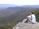
I just went with a friend and climbed mt Difficult starting and finishing at Troopers' creek. It was quite hard and they named the mountain right too.
It is great hike and the views from the top were grand.It was effing cold at the summit .
I can recommend it to fit and nimble footed hikers. There is a fair bit of rock scrambling involved.
Mt Difficult, Grampians day hike May 26 2013
Forum rules
Victoria specific bushwalking discussion. Please avoid publishing details of access to sensitive areas with no tracks.
Victoria specific bushwalking discussion. Please avoid publishing details of access to sensitive areas with no tracks.
13 posts
• Page 1 of 1
Mt Difficult, Grampians day hike May 26 2013
![]() by paidal_chalne_vala » Mon 27 May, 2013 7:54 pm
by paidal_chalne_vala » Mon 27 May, 2013 7:54 pm
- paidal_chalne_vala
- Lagarostrobos franklinii

- Posts: 2456
- Joined: Sun 22 Jan, 2012 10:30 pm
- ASSOCIATED ORGANISATIONS: VNPA.BTAC.Friends of Baw Baw.Mt.Bogong Club.
- Region: Victoria
- Gender: Male
Re: Mt Difficult, Grampians day hike May 26 2013
![]() by bmak » Tue 13 Aug, 2013 9:12 pm
by bmak » Tue 13 Aug, 2013 9:12 pm
I walked here yesterday staring from the Beehive Falls carpark and finishing at Troopers Camp. I then walked back to the car along the road.
Its a great walk with a variety of terrain and as mentioned plenty of rocks to get around or over.
The track was reasonably easy to follow although in a few places you need to stop and look around. I actually lost the track briefly descending to Troopers Camp as i followed a washed away section.
Its a great walk with a variety of terrain and as mentioned plenty of rocks to get around or over.
The track was reasonably easy to follow although in a few places you need to stop and look around. I actually lost the track briefly descending to Troopers Camp as i followed a washed away section.
- bmak
- Athrotaxis cupressoides

- Posts: 153
- Joined: Sun 13 Jun, 2010 8:26 pm
- Region: Victoria
- Gender: Male
Re: Mt Difficult, Grampians day hike May 26 2013
![]() by Lophophaps » Tue 13 Aug, 2013 10:19 pm
by Lophophaps » Tue 13 Aug, 2013 10:19 pm
bmak wrote:I walked here yesterday staring from the Beehive Falls carpark and finishing at Troopers Camp. I then walked back to the car along the road.
Its a great walk with a variety of terrain and as mentioned plenty of rocks to get around or over.
The track was reasonably easy to follow although in a few places you need to stop and look around. I actually lost the track briefly descending to Troopers Camp as i followed a washed away section.
For some time the descent from the summit has been a tad tricky. This usually occurs at bends, from memory mainly right bends, where the track goes over rock and the inclination is to go straight ahead. One party does that, making a little pad, than another and another. Soon a regular track seems to go straight ahead, the wrong way. Is this where you mean?
Where you cross the creek you can climb up beside it, day packs only, and get to a higher terrace. It's also possible to go straight up from the Troopers Creek road in a number of places. Other options are up from the east side and down Briggs Bluff, which I do not want to do again. We stopped walking a bit later than normal, 10 pm, delayed by terrain, no rope and no brains. These routes are best left to summer, or avoided.
-

Lophophaps - Auctorita modica

- Posts: 3382
- Joined: Wed 09 Nov, 2011 9:45 am
- Region: Victoria
- Gender: Male
Re: Mt Difficult, Grampians day hike May 26 2013
![]() by Kinsayder » Wed 14 Aug, 2013 12:40 pm
by Kinsayder » Wed 14 Aug, 2013 12:40 pm
I did this last year and felt like a bit of a dill when, descending, a couple who were sunning on some rocks nearby called out to me "track's that way" and pointed toward the track. I cannot recall the exact spot but it sounds like the same as that described. Glad I'm not alone!
-
Kinsayder - Athrotaxis cupressoides
- Posts: 361
- Joined: Tue 15 Nov, 2011 8:23 am
- Region: Victoria
Re: Mt Difficult, Grampians day hike May 26 2013
![]() by peregrinator » Wed 14 Aug, 2013 1:26 pm
by peregrinator » Wed 14 Aug, 2013 1:26 pm
Kinsayder wrote:I did this last year and felt like a bit of a dill when, descending, a couple who were sunning on some rocks nearby called out to me "track's that way" and pointed toward the track. I cannot recall the exact spot but it sounds like the same as that described. Glad I'm not alone!
You are far from alone. Here's my "bit of a dill" contribution.
After losing the track (quite likely at the very same spot) and then relocating it, I continued slightly downhill and then, slightly uphill, and then . . .
Haven't I seen this landscape before?!? Yes, I was heading back up to Mt Gar (aka Mt Difficult).
- peregrinator
- Athrotaxis selaginoides

- Posts: 1776
- Joined: Fri 15 Apr, 2011 2:50 pm
- Region: Victoria
Re: Mt Difficult, Grampians day hike May 26 2013
![]() by Kinsayder » Wed 14 Aug, 2013 1:52 pm
by Kinsayder » Wed 14 Aug, 2013 1:52 pm
It's always a worry when the downhill trip starts to go more up than down! 
-
Kinsayder - Athrotaxis cupressoides
- Posts: 361
- Joined: Tue 15 Nov, 2011 8:23 am
- Region: Victoria
Re: Mt Difficult, Grampians day hike May 26 2013
![]() by Snowzone » Wed 14 Aug, 2013 8:03 pm
by Snowzone » Wed 14 Aug, 2013 8:03 pm
I believe it is very common to become a little geographically embarrased on the Mt. Difficult/Briggs bluff area, yes I have done it too on a section heading down from the Bluff to Beehive Falls. I had gone down a gully a little further than I should of before realizing the error of my ways and I know I wasn't the only one as I was following the footprints of others. 
-
Snowzone - Phyllocladus aspleniifolius

- Posts: 533
- Joined: Sat 11 Dec, 2010 12:10 pm
- Region: Victoria
- Gender: Female
Re: Mt Difficult, Grampians day hike May 26 2013
![]() by bmak » Wed 14 Aug, 2013 8:17 pm
by bmak » Wed 14 Aug, 2013 8:17 pm
One thing I noticed is that there are stages that seem to be excessively marked then places that could do with any marking at all to help.
- bmak
- Athrotaxis cupressoides
- Posts: 153
- Joined: Sun 13 Jun, 2010 8:26 pm
- Region: Victoria
- Gender: Male
Re: Mt Difficult, Grampians day hike May 26 2013
![]() by Happy Pirate » Fri 16 Aug, 2013 10:11 pm
by Happy Pirate » Fri 16 Aug, 2013 10:11 pm
paidal_chalne_vala wrote:HI
I just went with a friend and climbed mt Difficult starting and finishing at Troopers' creek. It was quite hard and they named the mountain right too.
It is great hike and the views from the top were grand.It was effing cold at the summit .
I can recommend it to fit and nimble footed hikers. There is a fair bit of rock scrambling involved.
Done it many times and love it.
Another great loop is the Mt Stapylton loop from the Stapylton car park off Pohlners Rd. (about 10 km). It used to be my Sunday circuit when I lived in Natimuk (Horsham). The view of the Amphitheater with the resounding calls of dangling climbers is something special.
It can also be done from the Mt Zero carpark. Longer but less scrambling than Mt Difficult with an equivalent view from the 'top' (it's not actually the top but going further requires a good head for heights).
Particularly recommended for mid - late spring when the Parthenium and the sleepy lizards are out!
Steve
With a Glass Eye & 3 Wooden Legs:
http://www.glasseyephoto.com.au
http://www.glasseyephoto.com.au
-

Happy Pirate - Athrotaxis cupressoides
- Posts: 487
- Joined: Fri 02 Mar, 2012 2:32 pm
- Location: Hobart
- Region: Australia
- Gender: Male
Re: Mt Difficult, Grampians day hike May 26 2013
![]() by kez » Wed 30 Oct, 2013 1:36 pm
by kez » Wed 30 Oct, 2013 1:36 pm
I am heartened to know that others have had difficulty with the tracks on Mt Difficult. I attempted Briggs Bluff for the first time last weekend and was tripped up by my map (from Parks Victoria!) which suggested there was only one track from Beehive Falls only for me to come across an unmarked junction which led me to Mt Difficult (unbeknownst to me at the time). I reached Mt Difficult and on attempting to return I found myself on a completely different track (which turned out to be the track to Troopers Creek).
I was very surprised to find such a hard track to follow being so very poorly marked. Can anyone recommend a more detailed map of the Northern Grampians? One that shows ALL of the tracks? Thanks!
I was very surprised to find such a hard track to follow being so very poorly marked. Can anyone recommend a more detailed map of the Northern Grampians? One that shows ALL of the tracks? Thanks!
- kez
- Nothofagus cunninghamii

- Posts: 1
- Joined: Wed 30 Oct, 2013 1:24 pm
- Region: Victoria
- Gender: Female
Re: Mt Difficult, Grampians day hike May 26 2013
![]() by bmak » Thu 31 Oct, 2013 12:25 pm
by bmak » Thu 31 Oct, 2013 12:25 pm
I use vic map topo. It details grampians fairly well.
The tracks are accurate in osm if you don't want to pay anything
The tracks are accurate in osm if you don't want to pay anything
- bmak
- Athrotaxis cupressoides
- Posts: 153
- Joined: Sun 13 Jun, 2010 8:26 pm
- Region: Victoria
- Gender: Male
Re: Mt Difficult, Grampians day hike May 26 2013
![]() by trickos » Thu 31 Oct, 2013 2:58 pm
by trickos » Thu 31 Oct, 2013 2:58 pm
Spatial Vision's Northern Grampians Outdoor Recreation Map
https://svmaps.com.au/index.php?option= ... egory_id=4
https://svmaps.com.au/index.php?option= ... egory_id=4
-

trickos - Athrotaxis cupressoides
- Posts: 101
- Joined: Mon 08 Feb, 2010 2:55 pm
- Location: Geelong
- Region: Victoria
- Gender: Male
Re: Mt Difficult, Grampians day hike May 26 2013
![]() by roxyadelaide » Mon 16 Jan, 2017 10:28 pm
by roxyadelaide » Mon 16 Jan, 2017 10:28 pm
" What's re-opened recently:
Mt Difficult (Gar) & Briggs Bluff Overnight Walk
This popular overnight walk provides a challenging and remote experience for well prepared and experienced bushwalkers. It recently suffered damage from wildfire and requires strong navigation skills. The walking track has reopened with modifications. Start from Beehive Falls car park instead of Troopers creek campground (which has closed). There are two hiker camps available (which operate on a first in first served basis): Longpoint West Hiker Campsite 293 024 GDA94 Zone 54 Longpoint East Hiker Campsite 306 026 GDA94 Zone 54 Please note – the Briggs Bluff Hiker Campsite Grid ref 294 055 GDA94 and Mt Difficult Hiker Campsite - Grid Ref 284 030 GDA94 have now closed. Overnight camping is not permitted at these locations or elsewhere throughout the Mt Difficult Range. Planning is in place to replace the Mt Difficult Hiker camp with a Grampians Peaks Trail Hiker Camp."
Has anyone done the "new" Mt Difficult hike, how does it compare to the old Mt Difficult hike?
- roxyadelaide
- Nothofagus gunnii

- Posts: 22
- Joined: Fri 02 Oct, 2015 8:28 am
- Region: South Australia
- Gender: Female
13 posts
• Page 1 of 1
Who is online
Users browsing this forum: No registered users and 28 guests