This is hopefully my final submission. The earlier drafts should not be used, please. Those who have posted here or contacted me by PM have added greatly to the following. Many thanks.
I should have guessed that more information would come to light. Point 13 is new, added 7.12.15 6.30 am. Sorry about the constant changes but people keep giving me information.
***
Falls to Hotham Alpine Crossing – second submission
Introduction
1 On 20 November 2015 I made a submission regarding the proposed Falls Creek to Mt Hotham walk. Since then further and better particulars have become available. The following discusses that information.
Greater Alpine National Parks Draft Management Plan
2 The June 2014 Greater Alpine National Parks Draft Management Plan (ANP draft plan) appears to be the latest form of a management plan for the region. Hence, ANP draft plan shows the direction of Parks Victoria regarding the regions in the ANP draft plan, which includes between Falls Creek and Mt Hotham.
3 Starting on page iii, the Executive summary of the ANP draft plan says:
"The plan focuses on the outstanding natural, cultural and recreational values within the parks”
“The parks will be managed consistent with the National Parks Act 1975, to protect the natural environment, flora, fauna and features of scenic ... interest”
“People's heritage and connections to the land will be recognised and respected in the management of the parks”
“The key strategies are to ensure the public can enjoy a wide range of recreational and tourism experiences across the parks by ... pursuing key tourism initiatives including ... a serviced walking experience between Falls Creek (and) Mt Hotham”
“Improvements to visitor access will include ... development of a supported walk to be known as the Falls Creek to Mt Hotham Alpine Crossing".
4 Page 17 deals with zoning. A Conservation zone is defined as "Areas of high natural value where the emphasis is on protection of the environment." A Conservation and Recreation zone is defined as "Areas where the management emphasis is on protection of environmental and cultural values while allowing for recreation."
5 Page 62 has a goal: "A diverse range of opportunities for visitors to experience parks is maintained." (sic) Strategies include "Minimise the impact of visitors on environmental values ... develop a new hut‑based walk experience between Falls Creek and Mt Hotham (wild walk)".
6 Page 75 has a goal of "Sustainable nature‑based tourism" and a strategy to "Investigate the feasibility accommodation options for the Falls to Hotham Alpine Crossing (wild walk), including Red Robin Mine and demountable standing camps ... Feasibility study completed 2017".
7 There's a map showing zones at http://parkweb.vic.gov.au/__data/assets ... e-2014.pdf
8 The above gives a good basis for discussion.
Conflicts between the ANP draft plan and the proposed Falls-Hotham walk
9 Mt Feathertop and the Razorback are in a Conservation zone - "Areas of high natural value where the emphasis is on protection of the environment." The Preliminary concept plan for the proposed Falls-Hotham walk (“the walk Plan”) implies that there will be a new demountable standing camp or hut near Feathertop or approaches. This is contrary to Conservation zone values.
10 The ANP draft plan says: "The plan focuses on the outstanding natural, cultural and recreational values within the parks”. The proposed Falls-Hotham walk will compromise these values by having infrastructure and numbers that are not in keeping with a Conservation zone.
11 “People's heritage and connections to the land will be recognised and respected in the management of the parks.” The vast majority of people that that I know with long and profound contact with the region are strongly against the planned Falls-Hotham walk. I've been going to Feathertop and the Bogong High Plains for 42 years, long enough to have a right by association to claim connection. I've been involved in hut building, clearing tracks and weed suppression. We've been to these places summer and winter in starlight and storm, and place a very high value on them.
12 “Improvements to visitor access will include ... development of a supported walk to be known as the Falls Creek to Mt Hotham Alpine Crossing". There is no requirement in the ANP draft plan for this walk to go up Diamantina Spur. "Investigate the feasibility accommodation options for the Falls to Hotham Alpine Crossing (wild walk), including Red Robin Mine and demountable standing camps ... Feasibility study completed 2017". So the ANP draft management plan envisaged a walk up Machinery Spur, not Diamantina Spur. There's another year or two for the feasibility study to be done, and I discuss this below at point 25. There's also the question of how easy the walk should be and if everyone has a right to do such a walk. I suggest not. Not everyone can do everything – it's simply not possible. To do such a walk requires fitness, stamina and mental toughness. Short of carrying a person, no amount of support will allow people who do not have these personal traits to safely do the walk.
13 If the draft plan is the latest plan – and I cannot locate anything later – then taking action prior to that draft being approved is questionable. On a related matter, Falls Creek and Hotham resorts are promoting walks from their resorts with very similar wording. The Falls Creek walk is called “Falls to Hotham Alpine Crossing” - very similar to the one under consideration - and follows a different route to that of Parks Victoria. Like the Hotham to Falls Creek walk promoted by Hotham Heights, this walk information has a very significant number of errors and will entice people into jeopardy. There's also enticement to break the law, hardly a suitable action of a government department.
Inaccurate information
14 The walk Plan website http://www.tourismnortheast.com.au/alpine-crossing/ says
Day 1 Wallaces to Tawonga Huts
Day 2 Tawonga Huts to either Blairs or Diamantina Horseyards
Day 3 "involves a hike up Diamantina Spur to High Knob (night three) where walkers have the opportunity to walk to the summit of Mt Feathertop."
Day 4 is "via the Razorback finishing at Diamantina Hut near Mt Hotham".
15 The Plan poster at
http://www.tourismnortheast.com.au/wp-c ... educed.pdf
has conflicting and questionable information. It is also appallingly laid out, with far too much information for easy comprehension. The walk Plan is also very badly laid out. The soft fonts and poor contrast breach Equal Opportunity legislation, and remedies exist. It is unclear if this was intended or if those involved are unaware of good design maxims. If the poor design was intended, the only reason that I can envisage is to stop people from reading it easily or at all. Why is the design so poor?
16 The poster map is combined with a gradient section, and does not work. Cope Hut to Tawonga Huts is shown as 177 metres of climbing or descent; it does not say which. Wallaces car park to Tawonga is also shown as 177 metres. No descent or climbing from Wallaces car park to Cope Hut? Oops. My map shows that from Wallaces car park at about 1670 metres the track goes to the aqueduct at about 1600 metres, a descent of 70 metres. The climb to Cope Hut is about 100 metres. There's several ascents and descents to the high of 1810 metres before descending to Tawonga Huts at 1650 metres, down 160 metres. From the Wallaces car park to Tawonga Huts I calculate up 215 metres and down 210 metres. That is, the poster map has an error of 15% for this section. This does not inspire confidence.
17 The climbs and descents are indistinguishable from each other if you don't know the area or how to read maps. By glossing over ascents and providing false information, the walk appears easier than it is. Westons is shown as 1480 metres. It's closer to 1580 metres.
18 Night two is in two places, Blairs Hut and Diamantina Horseyards. This fits with the point 14 options. The horseyards are incorrectly shown as being above Blairs. Facts: Blairs 1120 metres, horseyards 1080 metres. The walk after the horseyards is labelled "Tawonga Huts to Diamantina Spur, 3 km 470 metres". Oops. Night three is wide: Diamantina Spur at 1540 metres (2 kilometres distance, 200 metres altitude and a good two hours up the spur to High Knob, possible camp #2. It's 40 minutes from here to Federation Hut, and another 30 minutes to Feathertop. Blairs-Diamantina Spur-Razorback is a solid and exhausting day for many.
19 Day 4 on the poster finishes at the summit of Mt Hotham. The other information says "finishing at Diamantina Hut near Mt Hotham". Diamantina Hut is on Mt Hotham. Why are two documents prepared at the same time for the same process in disagreement?
20 Hotham Heights is in the wrong place on the Plan map. (Hint: Hotham Heights is about a kilometre south-east of the shown position.) If they can't place a major ski resort accurately on a map then the capacity to manage the walk Plan is again cast into serious doubt.
21 The walk starts near Wallaces Hut, not Falls Creek. Describing the walk as between Falls Creek and Mt Hotham is misleading and arguably in breach of section 18 of Australian Consumer Law, which relates to misleading or deceptive conduct. Remedies exist. If as shown on the poster the walk finishes at “Diamantina Hut near Mt Hotham” then the finish is misleading as well, and s. 18 of ACL can be applied here as well. Oops.
22 There's ample evidence that the people managing the Plan have minimal idea about the terrain, details or how to present information. They don't know where Falls Creek or Hotham Heights are located. There's a huge number of other basic obvious errors in the Falls-Hotham walk information, rendering it unfit as a basis for consideration of the proposal. These errors are so significant that the entire process is of a very questionable standard and it must be started again. Any money paid to consultants must be recovered, as their efforts are abysmal, totally unfit for publication. If these monies are not recovered, it could be asked why public funds have been wasted. The consultant should also pay consequential damages. There are legal precedents for this; the case law is quite simple and well-established.
Economic analysis
23 The Plan has a heading Economic and social benefit which says:
"The Falls to Hotham Crossing will provide demonstrable economic benefits to the local community, the region and the State. It will support a wide range of investment opportunities for tourism, complementary services and infrastructure that provide an holistic and integrated walking experience."
24 This statement is presumptuous and should not be in the Plan. There has been no economic or cost-benefit analysis, so it's impossible to state how much the Plan will cost to set up and maintain. People will base their submission on the false and misleading advice that there will be economic benefits, apparently of substance with the benefits worth the cost. Hence, the entire process is cast into doubt. The quote in point 23 led to a comment: “What a wonderful sentence - absolute marketing fluff”. Quite.
25 The feasibility study is due to be completed 2017. Absent this study it is very hard to see why the Plan has been prepared. Parks Victoria recently advised that the economic component of the project “is programmed to commence early in the new year. The consultant team will work this up with Parks Victoria and make it available to the public for comment in mid-2016.” So the economic basis for the Plan is yet to be determined and will not be finalised until late-2016. It beggars belief that the consultants – who are most likely very highly paid – did not realise that the entire process is being done backwards. It's like Alice in Wonderland, “Sentence first, verdict afterwards.” For the matter under consideration it's “Plan first, economic justification afterwards.” More and more I'm coming to the conclusion that the consultants have not the faintest idea what they are doing, and are being paid under false pretences. Remedies exist at law for recovery of monies paid for results that do not meet a desired or acceptable standard.
26 Based on local and interstate experience, the total cost for the Plan will be approximately $1.28 million. (This will rise substantially if helicopters are needed more than anticipated.) Allow depreciation of 8% per annum, which is what Parks Victoria should be spending now to stop asset deterioration. (I note with interest that the state government will not provide adequate resources for Parks Victoria now. It very much appears that there will not be adequate resources for maintenance of the proposed walk infrastructure.) Maintenance will be about $200,000 a year. So there needs to be about $300,000 a year to pay for the proposed walk. This must come from commercial walks.
27 It's important to realise that the new infrastructure is only for commercial interests. Current users have no need for new infrastructure and strongly reject the need. New infrastructure is only for commercial interests, so it follows that these commercial interests should pay for it. This falls very firmly under user pays.
28 The weather is too risky for guided walking between late-March and mid-October, so allow 180 days of viable walking per year.
29 It's physically impossible to have more people at some campsites, and larger parties are discouraged under the ANP draft Plan and Parks Victoria policy, so allow eight per party. There must be two staff in each party for safety reasons, so there will be six paying walkers per party, around 1100 paying walkers a year for one party starting every day. This works out at about $300/person just to pay for the infrastructure. When trip costs and – presumably – profit are added and an allowance is made for tax at the corporate rate the cost per paying walker is about $1500, around $400/day, far higher than many will pay.
30 However, there will not be trips leaving every day for six months. Initially at least the take-up rate is likely to be quite low, and a little higher on an ongoing basis when the walk is established I can't see more than two or three trips per week. Hence, the commercial costs and all establishment and ongoing expenditure come to about $2000 per walker for just four walking days. Due to the initial capital expenditure and necessary replacements, a commercial operation will most likely be running at a loss for a few years. This means that the commercial operation will probably have to be a company big enough to sustain a loss. Key business metrics such as return on equity, return on investment, profit per equivalent full-time employee and net profit after tax are unattractive. Fixed costs will make losses more likely.
31 Unlike walks such as Tasmania's Overland Track (OLT) and New Zealand's Milford Track, it's possible to walk on many routes between near Falls Creek and Mt Hotham. The navigation is generally not hard – just follow the poles. There's dozens of places to camp and there's only one climb, much less climbing than Diamantina Spur, much easier. It's possible to hire gear and buy food for far less than $2000 and have essentially the same experience as a commercial package. Many would agree that a non-commercial trip is vastly superior to a commercial trip, and this is reflected in visitor numbers on the OLT. Once word gets around that there's a simpler less expensive option that gives greater freedom, then the attractiveness of any commercial trip will plummet and people will literally vote with their feet. With a gentle nudge and good information, most people will manage without support.
32 The OLT guided walks cost $3125 for 6 days, or around $500/day. This is staying in luxury huts with chefs cooking meals on a vastly superior walk, far more spectacular. Independent trips on the OLT cost $200, including staying in huts. The Milford Track takes four days and costs $A140 staying in huts, also more spectacular than Falls to Hotham. There's no comparison. If the Bogong High Plains region was on par with the OLT then the Bogong High Plains numbers would reflect this. They do not. Wilsons Prom is about the best Victoria can come up with compared to the OLT, and it's still way behind.
33 Paying $1500 to $2000 is not going to happen. The economics do not stack up. The preceding analysis should have been done first, prior to a public preliminary plan. The fact that there was no economic analysis first is hugely disappointing, and shows again that the proponents have no idea how to manage such a venture.
34 There will be something like seven full-time equivalent jobs. However, due to the uncertain nature of the walks, these jobs will not be ones that can be relied on for regular income. Instead, I suggest that there will be a pool of leaders who can be available at relatively short notice. The walker clients will spend nothing while on the walk but will spend in nearby towns, notably Mt Beauty, Bright, Harrietville and Mt Hotham. The spending will be of the order of $2-300 each for accommodation (probably arranged via the commercial walking company), meals, and sundry other smaller items.
35 Spending multipliers are difficult to measure, and a best estimate needs to be explored. The commercial walking company will incur expenditure related to their clients: food, fuel, accommodation and other items. There will be extra costs associated with higher tourism numbers such as utilities and garbage collection. Shortcomings in sampling mechanisms can throw the multiplier results out. Due to the preceding I decline to make even an estimate of the economic impact; to estimate is foolhardy.
36 However, while measuring the economic impact of the proposed walk is quite hard, there's a much simpler option. The number of winter visitors to Falls Creek and Mt Hotham is some orders of magnitude more than the 1000+ people that will use the proposed walk each year. Falls Creek and Mt Hotham are big enough to have thousands on the slopes at any one time. There are also numerous support staff. Many visitors stay for several days. Resort visitors and staff spend every day at the resort or in nearby towns, and much more than the modest walker. So the resorts have many more people in one day than would do the walk in a year, and the resort people will be spending multiples of the annual walking spending in just one day.
37 That is, the economic impact of the proposed walk is totally insignificant compared to winter visitation. This will not change. So while there may be “demonstrable economic benefits” from the Plan, these benefits are minuscule, with a very low ROI, and most probably a loss.
Environmental and safety matters
38 It seems that there may be an intention by commercial interests to have vehicular access to their first two overnight camps at Tawonga Huts and Diamantina Horseyards. If so then there's a conflict with the ANP Plan. Tawonga Huts has a 4WD track that's closed to non-management vehicles at the Pretty Valley gate. Allowing non-management vehicles past this gate detracts from the natural values of the region and is to be deplored.
39 The Diamantina Horseyards are just short of the locked gate on the West Kiewa River, and as such there's no issue with non-management vehicles entering where prohibited. However, there's a possible problem at both places in that there may be the intention in peak periods to have a fixed camp for the two or three parties a week. This would most likely be in Christmas-New Year, Australia Day and Easter. Fixed camps are acceptable for private groups but are unacceptable for commercial groups.
40 Diamantina Spur is over 700 metres of often steep exposed climbing. The climb is rated a medium or medium-hard and will take an unfit walker most of a day. As one gets higher the destination gets closer but tiredness will start to prevail. I know this spur – it's necessary to flex the mental muscles to keep going. Diamantina Spur is categorically not a place for unfit walkers. It's much harder than Milford or the OLT. The demographic of the target market for the walk is those who cannot manage without support. Such people will not have the requisite fitness to undertake the spur, making it highly probable that rescues will be necessary. If the weather is bad the chance of a death is increased. It's now a matter of public record that I have made this prediction. I hope I'm wrong. If I'm right then those responsible for suggesting this dangerous walk should be charged. Custodial sentences are apt.
41 Point 14 above shows how there is a proposal to camp at High Knob for night three. (Another variation of the 1540 metres Diamantina Spur or Federation Hut cited elsewhere in the Plan documentation.) High Knob is very exposed and has no water. Disposal of human wastes means that a toilet will have to be built. If the weather really deteriorates then a party a few hours below High Knob has two choices, neither of them very palatable. Walk to Federation Hut and down the Bungalow Spur. I've been in strong winds there and have been blown off my feet. In a blizzard, novice walkers would be put at risk. Can't happen? As I write this in early December the Victorian alps has a blizzard, snow falling. The other option is to go down Diamantina Spur, much of which is exposed and quite steep. A rock bluff needs to be negotiated, easy to slip, with injury or death resulting. High Knob and 1540 metres are dreadful places to camp on a regular basis. People without tents have died attempting to reach a hut, so the risks of establishing a hut or standing camp at High Knob are known.
42 Any proposal to build a hut or allow a standing camp at or near at High Knob is contrary to the ANP Plan and breaches a number of very basic park axioms, including visitor safety.
Market understanding
43 The Plan says:
"The Falls to Hotham Alpine Crossing is recognised by the Victorian government as one of four long-distance walks being developed under the Walk Victoria Icons brand which will position Victoria and the Australian Alps as a key nature-based destination."
44 Falls to Hotham is not a long-distance walk; it's a weekend via Dibbins and a moderate three days via Blairs and Feathertop. Calling Falls-Hotham long distance will not “position Victoria and the Australian Alps as a key nature-based destination." The long-distance description will bring Victoria into disrepute and make Victoria the subject of adverse remarks; this is already the case. “Long-distance” must be removed.
45 Long-distance walking is at least 6-10 days, depending on the terrain and climate. The lack of understanding of what constitutes a long-distance walk again shows that those managing the Plan have no idea what they are doing. The Plan is driven by false ideology that is most probably based on wishing to be seen as better than places such as the OLT. Tasmania has vastly superior scenery, and this will not be changed by marketing and spin. Ideology is never a good basis for action.
46 One person said “An icon is an image or a representation … so an 'icon walk' will be an image of a walk - no reality, that will be lost with the exploitation, just an image, or a representation, of what was.” This sums up the Plan nicely.
Summary
47 This misguided attempt to create silk from straw will not succeed. There are serious conflicts between the 2014 Greater Alpine National Parks Draft Management Plan and the Falls-Hotham walk proposal. Those involved do not know the region and cannot even get basics right like placing a ski resort correctly on a map or stating where the walk ends. The Plan is economically, environmentally and aesthetically irresponsible, with false and misleading information that breaches the the ANP Plan and consumer laws. The Plan is manifestly dangerous, placing visitors at risk, which is contrary to the Draft Management Plan. Very little makes sense. The walk proposal is borne from fundamentally flawed ideology and is unlikely to succeed. The walk proposal will bring Victoria into disrepute. Already there is much mirth at the Plan – Victoria and the government are the subject of derision.
48 To make it quite clear, I'm strongly against the Plan.
*** ends
Falls Creek to Mt Hotham Alpine Crossing
Forum rules
Victoria specific bushwalking discussion. Please avoid publishing details of access to sensitive areas with no tracks.
Victoria specific bushwalking discussion. Please avoid publishing details of access to sensitive areas with no tracks.
Re: Falls Creek to Mt Hotham Alpine Crossing
![]() by Lophophaps » Sun 06 Dec, 2015 5:28 pm
by Lophophaps » Sun 06 Dec, 2015 5:28 pm
-

Lophophaps - Auctorita modica

- Posts: 3383
- Joined: Wed 09 Nov, 2011 9:45 am
- Region: Victoria
- Gender: Male
Re: Falls Creek to Mt Hotham Alpine Crossing
![]() by paidal_chalne_vala » Sun 06 Dec, 2015 10:10 pm
by paidal_chalne_vala » Sun 06 Dec, 2015 10:10 pm
Swimming is banned at Rocky valley dam. The sign up there says so.
- paidal_chalne_vala
- Lagarostrobos franklinii

- Posts: 2469
- Joined: Sun 22 Jan, 2012 10:30 pm
- ASSOCIATED ORGANISATIONS: VNPA.BTAC.Friends of Baw Baw.Mt.Bogong Club.
- Region: Victoria
- Gender: Male
Re: Falls Creek to Mt Hotham Alpine Crossing
![]() by Xplora » Mon 07 Dec, 2015 5:43 am
by Xplora » Mon 07 Dec, 2015 5:43 am
paidal_chalne_vala wrote:Swimming is banned at Rocky valley dam. The sign up there says so.
There may be an exclusion zone near the dam wall but they hold swimming events in the water.
Good work Lops. Point 11 I think had 'that that' but that was all I could find. Quite possibly the concept plan is more about the realignment of the track to make it more enticing to commercial interests and maybe a bit more scenic.
- Xplora
- Athrotaxis selaginoides

- Posts: 1578
- Joined: Sat 01 Aug, 2015 7:24 am
- Region: Victoria
- Gender: Male
Re: Falls Creek to Mt Hotham Alpine Crossing
![]() by Lophophaps » Mon 07 Dec, 2015 5:49 am
by Lophophaps » Mon 07 Dec, 2015 5:49 am
paidal_chalne_vala wrote:Swimming is banned at Rocky valley dam. The sign up there says so.
Thanks for that. I've added a new par, 13, that mentions illegal suggestions and the resort-sponsored walks. I really thought that the submission was final. Now it is. Maybe! LOL.
The next step is to be to come up with questions to ask at the briefing on 11 December. While I could do this it seems to me better that others have input as you will have better perspective than me. Here's a start.
* Why has PV undertaken planning when the ANP management plan is not finalised?
* Why has PV undertaken planning when there is no economic analysis?
* Economic benefits will be tiny compared winter. Why bother?
* Why are the PV walk documents so full of errors?
* Why is the planned walk so dangerous? (Hammer safety - D. Spur is 700 metres, big!)
* Why is there a planned hut or standing camp at or near High Knob, contrary to the zone?
* How will the hut or standing camp at or near High Knob be supplied?
-
Lophophaps - Auctorita modica
- Posts: 3383
- Joined: Wed 09 Nov, 2011 9:45 am
- Region: Victoria
- Gender: Male
Re: Falls Creek to Mt Hotham Alpine Crossing
![]() by paidal_chalne_vala » Mon 07 Dec, 2015 12:29 pm
by paidal_chalne_vala » Mon 07 Dec, 2015 12:29 pm
I have just received an email saying the the PV briefing on this issue is to be held this week. It reads like this :
"
Parks Victoria together with Tourism North East, Visit Victoria and Regional Development Victoria invites you to attend the:
Falls to Hotham Alpine Crossing preliminary concept – Melbourne stakeholder briefing
The Falls to Hotham Alpine Crossing will be a world-class, long-distance walking experience, showcasing the beauty of the Alpine National Park’s natural and cultural landscape.
The project team would like to invite you to contribute your feedback through an open briefing session with the project and consultant team.
When: Friday 11 December 10.00am - 11.30pm
Where: Karsten Conference Centre, 123 Queen St Melbourne Vic 3000, Level 11, Room 1105
RSVP: Thursday 10 December
Email: [email protected]
If you are unable to attend this briefing session but would still like to provide feedback, please email your comments to the project team at: [email protected]
The Falls to Hotham Alpine Crossing preliminary concept can be accessed via the following link:
http://parkweb.vic.gov.au/explore/parks ... aster-plan"
I cannot attend. I will be either working or trekking at the Prom. I suspect by hoisting it upon us at the 11th hour they will keep us annoying greenies and better informed opponents away.
- paidal_chalne_vala
- Lagarostrobos franklinii
- Posts: 2469
- Joined: Sun 22 Jan, 2012 10:30 pm
- ASSOCIATED ORGANISATIONS: VNPA.BTAC.Friends of Baw Baw.Mt.Bogong Club.
- Region: Victoria
- Gender: Male
Re: Falls Creek to Mt Hotham Alpine Crossing
![]() by Xplora » Tue 08 Dec, 2015 5:19 am
by Xplora » Tue 08 Dec, 2015 5:19 am
We walked out to Weston's hut yesterday via Mt. Cope and a quick add up of the numbers in the book had about 200 people since October through. Most of the big groups were school kids. There will of course be more people like me who do not write in the books but this would be how Parks estimate visitor numbers which would do to the economic viability. It was a new book so I could not go back to last walking season.
In order to enhance the experience of those not prepared to carry their own gear and camp on the ground this proposal will, aided by a team of landscape architects, take away the experience for the rest by adding structures to the landscape and sterilising the walk. The cost of which will then be borne by either the government or the commercial interests who in turn will place a fee and restrictions on the use of the track making it no longer available to all unless they can afford to pay.
The track from Weston's to Blair's is also the horse track with Cobungra gap restricted to walkers only. I am wondering if they are considering the use of pack horses to assist with supplies. I am also thinking the realignment of the track is also about giving it an identity away from the AAWT.
My questions.
1. Is it the intention of PV to charge all people to camp at all the current camp sites along the proposed route?
2. Will there be any provision for people to walk this route without using the proposed commercial camping infrastructure?
3. Will the track receive maintenance and infrastructure upgrade such as boardwalk, steps and handrails and if so who will be paying for it?
- Xplora
- Athrotaxis selaginoides
- Posts: 1578
- Joined: Sat 01 Aug, 2015 7:24 am
- Region: Victoria
- Gender: Male
Re: Falls Creek to Mt Hotham Alpine Crossing
![]() by Xplora » Tue 08 Dec, 2015 5:24 am
by Xplora » Tue 08 Dec, 2015 5:24 am
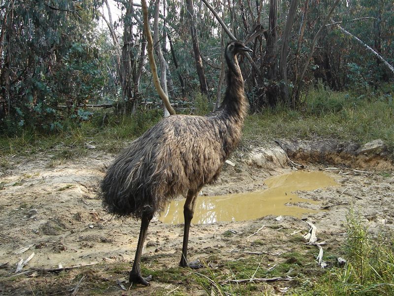
Another question. Has anyone ever seen an emu on the High Plains? The information says you may see them but I never have.
- Xplora
- Athrotaxis selaginoides
- Posts: 1578
- Joined: Sat 01 Aug, 2015 7:24 am
- Region: Victoria
- Gender: Male
Re: Falls Creek to Mt Hotham Alpine Crossing
![]() by Lophophaps » Tue 08 Dec, 2015 8:44 am
by Lophophaps » Tue 08 Dec, 2015 8:44 am
Xplora wrote:In order to enhance the experience of those not prepared to carry their own gear and camp on the ground this proposal will, aided by a team of landscape architects, take away the experience for the rest by adding structures to the landscape and sterilising the walk. The cost of which will then be borne by either the government or the commercial interests who in turn will place a fee and restrictions on the use of the track making it no longer available to all unless they can afford to pay.
That sums it up nicely. The Tassie Three Capes fiasco is a case in point - destroy nature so people can see it. Like many others I don't want everything to be of a high standard. Somewhat decrepit has charm. (I'm not saying that I'm decrepit!) Making the environment suitable for the least fit and least prepared detracts. It's like wilderness where those of us with the skills can go.
Xplora wrote:The track from Weston's to Blair's is also the horse track with Cobungra gap restricted to walkers only. I am wondering if they are considering the use of pack horses to assist with supplies. I am also thinking the realignment of the track is also about giving it an identity away from the AAWT.
My questions.
1. Is it the intention of PV to charge all people to camp at all the current camp sites along the proposed route?
2. Will there be any provision for people to walk this route without using the proposed commercial camping infrastructure?
3. Will the track receive maintenance and infrastructure upgrade such as boardwalk, steps and handrails and if so who will be paying for it?
Pack horses - interesting. I cannot recall pack horses in the ANP draft plan. I suspect that if horses are allowed then pack horses are allowed as well.
Good questions. To question 3 I'd add 'If so, will this be done before the start of commercial operations?"
Xplora wrote:Another question. Has anyone ever seen an emu on the High Plains? The information says you may see them but I never have.
Never. Brumbys, wombats, koalas, snakes, sundry wildlife, no emus. Another piece of imaginative copywriting, methinks
-
Lophophaps - Auctorita modica
- Posts: 3383
- Joined: Wed 09 Nov, 2011 9:45 am
- Region: Victoria
- Gender: Male
Re: Falls Creek to Mt Hotham Alpine Crossing
![]() by peregrinator » Tue 08 Dec, 2015 8:54 am
by peregrinator » Tue 08 Dec, 2015 8:54 am
Xplora wrote:Another question. Has anyone ever seen an emu on the High Plains? The information says you may see them but I never have.
Good question, Xplora. I've not seen or heard one, nor seen any scats.
Simpson and Day, Field guide to the birds of Australia, shows that emu are absent from the alpine region.
- peregrinator
- Athrotaxis selaginoides
- Posts: 1781
- Joined: Fri 15 Apr, 2011 2:50 pm
- Region: Victoria
-
Lophophaps - Auctorita modica
- Posts: 3383
- Joined: Wed 09 Nov, 2011 9:45 am
- Region: Victoria
- Gender: Male
Re: Falls Creek to Mt Hotham Alpine Crossing
![]() by paidal_chalne_vala » Tue 08 Dec, 2015 11:25 am
by paidal_chalne_vala » Tue 08 Dec, 2015 11:25 am
"Emus" :Yes. I thought that was odd too. Emus do not inhabit the alpine areas of Victoria, esp. above the tree line. There are Emus at the Prom. and the Grampians, but on the Bogong high plains: NEVER.
Last edited by paidal_chalne_vala on Thu 10 Dec, 2015 6:17 pm, edited 1 time in total.
- paidal_chalne_vala
- Lagarostrobos franklinii
- Posts: 2469
- Joined: Sun 22 Jan, 2012 10:30 pm
- ASSOCIATED ORGANISATIONS: VNPA.BTAC.Friends of Baw Baw.Mt.Bogong Club.
- Region: Victoria
- Gender: Male
Re: Falls Creek to Mt Hotham Alpine Crossing
![]() by Xplora » Tue 08 Dec, 2015 11:58 am
by Xplora » Tue 08 Dec, 2015 11:58 am
The following is my submission regarding Falls Creek to Hotham crossing:
I live on the border of the Alpine National Park with a view of the Bogong High Plains and regularly walk the area in winter and summer and on many occasions take our visitors with us. I am concerned about the development proposals and the encroachment of private concerns further into the park.
The concept plan suggests the realignment of the walk from its present position is part of making it a ‘Victorian Icon long walk’. It is in no way a long walk but it can afford some good views which indicates to me the private concerns are driving the realignment for this purpose and wish to make the walk attractive to a less than enthusiastic hiker who is prepared to pay big for the Alpine experience in comfort and support instead of carrying everything themselves. In order to do this considerable effort will need to exhausted to make Diamantina spur suitable for an average walker. I doubt it is even possible. A realignment of the AAWT to include Mt. Feathertop and Mt. Bogong has already been rejected. Diamantina spur is for most experienced and fit walkers extremely difficult so to lure people into this walk, which on the first two days is relatively easy, with fluffy marketing hype is a blatant grab for tourist money and shows little concern for the welfare of the client. I understand alternate routes are outlined and these routes, although still steep, are much easier and can be better supported. Machinery spur has vehicle access. I fail to see how a camp at High Knob along the Razorback can be fully supported without the aid of a helicopter or a large number of porters.
With regard to the accommodation precincts and the type of accommodation provided I have more concerns. Firstly the Razorback is in a conservation zone and although it is suggested demountable ‘glamping’ will be provided in reality it would be difficult to achieve that level of comfort, remove it regularly and keep it fully supported without considerable expense and interruption to the environment. This expense would be have to be passed on to the consumer and since no economic viability study has been conducted much of this discussion could be mute. It is the intention of the development team and the landscape architects to place the accommodation in areas to afford good vistas. Doing this also means destroying the vista regardless of how it is blended into the scenery not to mention destroying the area it is to placed on. This is contrary to the zone of the area.
It is indicated other areas will have various levels of accommodation and with it an appropriate price tag. Once this occurs those who camp in a minimalistic way and have used the listed precincts for many years will invariably be shut out in order to protect the investment of commercial concerns. Large sections of the walk and the associated campsites are used extensively by school groups for their outdoor education programs. The track from Weston’s hut to Blair’s is also used frequently by horse groups as Cobungra Gap is restricted to walkers only. In addition there are hundreds of others using the track who will then be discriminated against unless they can afford to pay. The 3 capes walk in Tasmania is receiving considerable public backlash for this very reason and since it is the view of the development team to emulate Tasmania and New Zealand then the Victorian government can expect similar backlash should it go ahead. It seems the natural beauty and remoteness of the area will be destroyed for those who currently enjoy it in order for a select few to have an enhanced experience in luxury and style.
The entire proposal smells strongly of an Alpine resort driven enterprise. I know there are a number of players involved but as the profits from the ski season fade the resorts feel the need to stretch their tentacles further into the park to prop up their dwindling returns. The resorts have shown little commitment for green events in the past and are now playing catch up for fear of losing their relevance. Their proposals and promises may seem lucrative to a government stretched for resources, struggling to maintain tracks and a presence, but it will come at a cost. Some people in Falls Creek tried many years ago to provide for summer tourism but received little support from management and their ventures failed. They were a ski resort and operated from June to October as far as management were concerned. Attitudes have changed because they are dying. The level of influence Alpine resorts have is astounding when compared to their size. Is it the attitude of the government that ski resorts need to propped up financially? You may see me as a cynic but I have read a great deal of the marketing spin from resorts. Enough to know they are concerned only about the dollar and not the environment, the truth, or the welfare of their clients. If the dollar is not there they will be the first to desert the ship and leave the government with half a project, a wasted investment and a scarred landscape. To attract the client with money, those who wish to be guided and fully supported, they will want to sterilise the tracks with raised boardwalk, steps, handrails and evenly formed tracks with interpretive signs accompanied by bench seats to rest. This is not the experience most who travel and enjoy the route now would seek and development of the track in the way proposed would make it less appealing to the majority and available only to an elitist few.
This track is also not in the same class as others offered where similar development has occurred and those in the private sector trying to market it in that way should not be believed. I would suggest without the proposed realignment to include the Razorback and Mt. Feathertop the private money would not be as enthusiastic. With the realignment they will be pushing it uphill, pun intended, to get people to walk up Diamantina spur. Reversing the walk would put High Knob accommodation logistically in a poor position and therefore not viable.
There may be opportunity for supported and guided walking along the current route to support tourism in the area as long as it is not to the exclusion of those who cannot afford to pay. Perhaps a simpler version could be considered before significant money is spent on track upgrades, fancy camping facilities and environmental vandalism. This would serve as a guide to the economic viability of the walk.
- Xplora
- Athrotaxis selaginoides
- Posts: 1578
- Joined: Sat 01 Aug, 2015 7:24 am
- Region: Victoria
- Gender: Male
Re: Falls Creek to Mt Hotham Alpine Crossing
![]() by sambar358 » Tue 08 Dec, 2015 2:13 pm
by sambar358 » Tue 08 Dec, 2015 2:13 pm
I have seen emus often between Dinner Plain & Hotham on the southern side of the Alpine Rd...on Paw Paw Plain & on occaions in the spring on the grassy faces and basalt benches below Mt. Tabletop. Get them on the trail cameras now and again having a drink or a mud bath around sambar wallows and I've found the odd emu remnants in these areas after a dingo kill. All this country is quite high at 1550+m but they are certainly there over the warmer months, not sure about over on the Bogong HP's but it's similar country and they could-well be there too.
These few trail camera shots were taken on a sambar wallow in March a couple of years ago at around 1500m down in the fire re-gen....quite a large group of around a dozen birds spent most of a week around this wallow cooling off and seemingly enjoying getting wet and dirty. But I guess they are like a lot of the high country critters.....you need to look for them or get lucky and bump into one just by chance......there are 1000's of sambar deer in all that country too but how many do you see ? Cheers
s358
High country bush chooks :
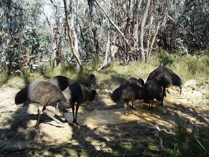
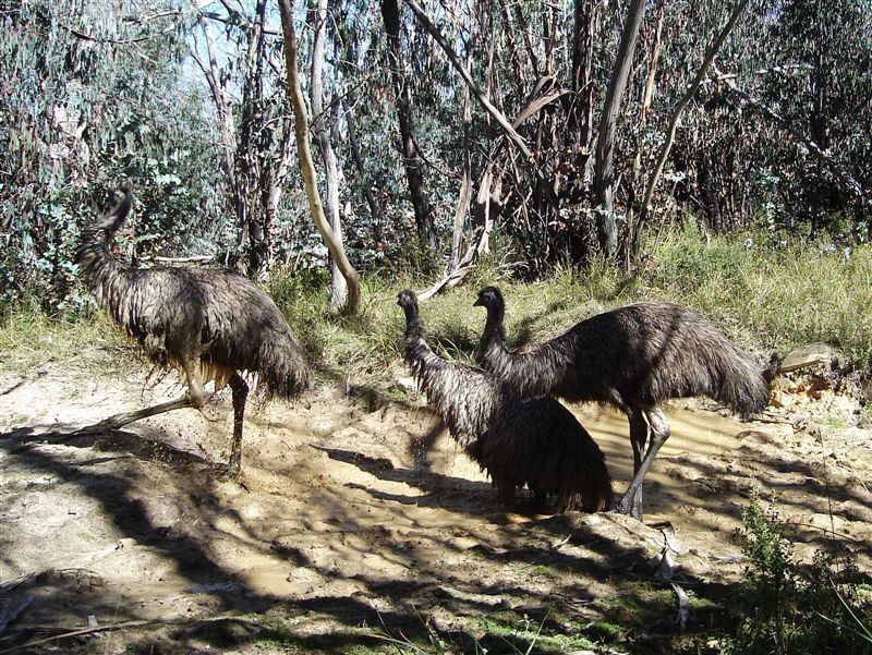


- sambar358
- Athrotaxis cupressoides

- Posts: 392
- Joined: Sat 25 Oct, 2008 10:05 am
Re: Falls Creek to Mt Hotham Alpine Crossing
![]() by sim1oz » Tue 08 Dec, 2015 6:03 pm
by sim1oz » Tue 08 Dec, 2015 6:03 pm
Wow, emus in alpine areas! Clearly, they are people shy and don't steal sausages from off the barbie the way the emus in Tower Hill do... Great photos and write up, sambar358. I just learnt a few new things about our bush chooks.
Carpe diem!
-

sim1oz - Athrotaxis cupressoides
- Posts: 479
- Joined: Mon 17 Jan, 2011 10:15 pm
- Region: Victoria
- Gender: Female
Re: Falls Creek to Mt Hotham Alpine Crossing
![]() by Xplora » Wed 09 Dec, 2015 4:55 am
by Xplora » Wed 09 Dec, 2015 4:55 am
Emu's are not as shy as Sambar. I had heard of some near Dinner Plain but for some reason none are on the BHP. I am sure if they were around I would have seen them at some stage. I spend far more time up there than at Dinner Plain. Good pics Doug.
- Xplora
- Athrotaxis selaginoides
- Posts: 1578
- Joined: Sat 01 Aug, 2015 7:24 am
- Region: Victoria
- Gender: Male
Re: Falls Creek to Mt Hotham Alpine Crossing
![]() by Lophophaps » Wed 09 Dec, 2015 8:07 am
by Lophophaps » Wed 09 Dec, 2015 8:07 am
Does anybody have any more questions? So far all that have been posted are:
1 Why has PV undertaken planning when the ANP management plan is not finalised?
2 Why has PV undertaken planning when there is no economic analysis?
3 Economic benefits will be tiny compared winter. Why bother?
4 Why are the PV walk documents so full of errors?
5 Why is the planned walk so dangerous? (Hammer safety - D. Spur is 700 metres, big!)
6 Why is there a planned hut or standing camp at or near High Knob, contrary to the zone?
7 How will the hut or standing camp at or near High Knob be supplied?
Xplora
8 Is it the intention of PV to charge all people to camp at all the current camp sites along the proposed route?
9 Will there be any provision for people to walk this route without using the proposed commercial camping infrastructure?
10 Will the track receive maintenance and infrastructure upgrade such as boardwalk, steps and handrails and if so who will be paying for it?
Question 10 could be expanded to ask "paying for it? If so, will the upgrade be prior to the commencement of walks?'
Are there any other points? Is anyone going to the briefing who can ask these questions? If not they can be sent by email.
-
Lophophaps - Auctorita modica
- Posts: 3383
- Joined: Wed 09 Nov, 2011 9:45 am
- Region: Victoria
- Gender: Male
Re: Falls Creek to Mt Hotham Alpine Crossing
![]() by paidal_chalne_vala » Thu 10 Dec, 2015 5:54 pm
by paidal_chalne_vala » Thu 10 Dec, 2015 5:54 pm
This is the submission I have sent to PV via express post snail mail on Wednesday Dec. 9th 2015.
Thanks to Lop.s who helped me polish it a bit and make it look smart.
"
Falls Creek-Mt Hotham walk
Submission
The planned development of walking tracks between Falls Creek and Mt Hotham concerns me. A further submission regarding this matter is set out below.
Does anyone know how much it costs to make a walking track in a semi-remote region like near Tawonga Huts, Blairs Hut and Diamantina spur?
From the plan:
"The Falls to Hotham Crossing will provide demonstrable economic benefits to the local community, the region and the State. It will support a wide range of investment opportunities for tourism, complementary services and infrastructure that provide an holistic and integrated walking experience."
What economic benefits? The economic analysis will be carried out and available for examination in mid-2016.There is no proof that the plan quote above is fact. It is conjecture with no basis, hard figures or a completed cost analysis that is available to the public.
The Plan says:
"The Falls to Hotham Alpine Crossing is recognised by the Victorian government as one of four long-distance walks being developed under the Walk Victoria Icons brand which will position Victoria and the Australian Alps as a key nature-based destination"
Falls to Hotham is claimed to be “long-distance”. Faster walkers will do this in a weekend. It's about 17 kilometres from Falls Creek to Blair’s hut, and slightly more on day two, Feathertop and Razorback to Hotham. It is best done as a three day trip perhaps.
Long-distance walking is at least 6-10 days, depending on the terrain and climate. The Australian Alps Walking Track (AAWT) is 650 kilometres; that's a long-distance walking track.The AAWT takes 6-8 weeks to complete from Walhalla in Victoria to Tharwa in the A.C.T.
The dearth of comprehension shown here of what actually is a real long-distance walk again shows that those managing the proposal have no concept about what they are trying to achieve. Not a clue. I doubt they have even walked in this area themselves. Falls Creek to Mt Hotham is not a long-distance walk. Falls to Hotham is a weekend hike via Dibbins Hut and a moderate three days via Blairs Hut and Mt Feathertop.
Calling Falls-Hotham long distance will not “position Victoria and the Australian Alps as a key nature-based destination." The long-distance description will bring Victoria’s name in the outdoor walking community and in the world of tourism into disrepute and will make Victoria the subject of sarcastic remarks. This plan is already being laughed by regular hikers at as a farce and a bad idea.
It greatly concerns me that people who are not equipped with adequate fitness, stamina, gear and experience may be enticed into potentially dangerous areas with the only resort in an emergency may be a Personal Locater Beacon, if they have one. This is because mobile phone reception is unreliable in this area.
The trip is not even Falls to Hotham: it starts near Wallaces Hut, about 8 kilometres from Falls Creek ski resort. The walk does not conclude at Mt Hotham ski village either so the name of the proposed walk is wrong. Note where Hotham Heights is on the map - west of Loch car park. If they cannot find and correctly place a major ski resort on a map then what idea do they have about the actual ground reality and details of the area?
The planned High Knob accommodation depicted in this online poster shows significant structures that would be hard to provide with services unless a huge rain water tank is installed. Electric power would have to come from solar panels. A helipad would have to be built in the saddle by Twin Knobs in order to carry all supplies in. This is crazy. It is the start of building another ski resort!
A fierce storm or bushfire could wipe it all out in a day. It's very exposed and not a sensible or safe place to build anything. Maintaining walking tracks and buildings in such a harsh environment would be very expensive, with ongoing costs ensuring little return on investment.
If the return of investment was to be guaranteed, without officially costed figures to back it all up I guess the operators would have to charge between $1000 to $2500 per person for three nights and somehow exclude the general public from accessing the all tents only campsites in the area and all the walking routes in the area in general. This is a national park. Legislation would have to be amended to make such exclusive private enterprise legal. It is at odds with the basic purpose of why national parks exist in the first place. They are not for building privately operated resorts.
National parks are for conservation, and enforcing such regulations would not be cost-effective. Rangers are not employed to act as police and it is stupid to make them enforce such foolish laws.
Paying between $1000 and $2500 just to go hiking and camping or staying in a hut for three or four days is more than most people will be prepared to pay. Early on the people won’t come every day or be prepared to pay that much. I can do the same hike for less than $200 on my own or with friends. It takes time for an attraction or a business to get going. This means operators will be running at a loss for years.
The probable cost for walkers will be too high for a viable commercial operation. The business case should have been done first, before the current consultation process.
Alpine weather can turn to a blizzard with zero visibility all year round. This means the certainty required for safe walking days to get a return on investment would be insufficient if you only operated the hikes from November the first to the end of March every year. It's very slippery in the snow and rain on the very steep Diamantina Spur. If operators ignore the warnings the weather is giving and push on up or down the spur in bad weather, then people will die in the course of putting dollars ahead of all other considerations.
Regular walkers in the area know turning back when ascending these mountains is the wise option in bad weather but descending in bad weather is also hazardous for novices too. The coroner would be obliged to ask questions about these issues if the worst case scenario occurred.
Another brochure is available online about this plan:
http://www.tourismnortheast.com.au/wp-c ... educed.pdf
This shows a picture of Mt. Hotham, the caption says Mt. Feathertop. The Mt Feathertop picture in this same pamphlet says it's Mt Hotham. This brochure is hard to read and confusing, and the people that created it have no idea which mountain is which. How can the people pushing for this development manage it properly if they can’t even get this right?
This is indicative of how the people behind this scheme have never visited the area. It could be on the moon for them, for all they care, as long they get their consultants’ fees. Such slap-dash work in the preliminary stage is a waste of taxpayers’ money and says all the wrong things about those who are involved in the design of the promotional material and the scheme overall.
Another concerned walker has said “An icon is an image or a representation … so an "icon walk" will be an image of a walk - no reality, that will be lost with the exploitation, just an image, or a representation, of what was.”
The proposal is created from an ideology that is fundamentally flawed and will never succeed. It gambles on killing the goose (unspoilt beauty and wild untamed nature) that lays the golden egg in order to sell many more golden eggs (overpriced hikes).
I urge all those involved to abandon this hare-brained scheme. It is bereft of merit on any level."
- paidal_chalne_vala
- Lagarostrobos franklinii
- Posts: 2469
- Joined: Sun 22 Jan, 2012 10:30 pm
- ASSOCIATED ORGANISATIONS: VNPA.BTAC.Friends of Baw Baw.Mt.Bogong Club.
- Region: Victoria
- Gender: Male
Re: Falls Creek to Mt Hotham Alpine Crossing
![]() by paidal_chalne_vala » Thu 10 Dec, 2015 5:57 pm
by paidal_chalne_vala » Thu 10 Dec, 2015 5:57 pm
I didn't know there were Emus in the Alpine areas. I have never seen any myself and I walk in the Alpine N.P. quite a bit.
- paidal_chalne_vala
- Lagarostrobos franklinii
- Posts: 2469
- Joined: Sun 22 Jan, 2012 10:30 pm
- ASSOCIATED ORGANISATIONS: VNPA.BTAC.Friends of Baw Baw.Mt.Bogong Club.
- Region: Victoria
- Gender: Male
Re: Falls Creek to Mt Hotham Alpine Crossing
![]() by Xplora » Fri 11 Dec, 2015 4:38 am
by Xplora » Fri 11 Dec, 2015 4:38 am
paidal_chalne_vala wrote:This is indicative of how the people behind this scheme have never visited the area. It could be on the moon for them, for all they care, as long they get their consultants’ fees. "
I do know the project team have been taken through the area by the local staff and have spent a bit of time on the ground. Not sure if that has translated into any understanding of the area. The impression I got was they did not walk the intended route. Perhaps that would have changed their thinking.
- Xplora
- Athrotaxis selaginoides
- Posts: 1578
- Joined: Sat 01 Aug, 2015 7:24 am
- Region: Victoria
- Gender: Male
Re: Falls Creek to Mt Hotham Alpine Crossing
![]() by Lophophaps » Fri 11 Dec, 2015 5:45 am
by Lophophaps » Fri 11 Dec, 2015 5:45 am
Xplora wrote:I do know the project team have been taken through the area by the local staff and have spent a bit of time on the ground. Not sure if that has translated into any understanding of the area. The impression I got was they did not walk the intended route. Perhaps that would have changed their thinking.
Maybe 95% of the walk is on well-known and well-established tracks. The only parts that lack a track are near Tawonga Huts and at the bottom of Diamantina Spur. The Tawonga Huts section is easy open ground which only need works to maintain stability and prevent erosion. I've walked and skied here, pleasant. The Diamantina Spur section is in scrub on steep slopes, and the consultants are in my view excused if they did not walk this section. That's the job for the people building the track.
The project team should all have walked up Diamantina Spur to see how big it is, to grasp that this is not a spur that is lightly dismissed as just another part of the walk. Diamantina Spur is the main stumbling block - long and steep for those who lack the fitness, stamina and mental tenacity to do it. I fund Diamantina Spur to be harder than T Spur, which is about the same height. The Bungalow is longer and taller but is better graded and has a few creeks and soaks.
If the project team has not walked up Diamantina Spur and the rest of the proposed walk then they are derelict in their duties. Not walking up Diamantina Spur is especially hard to understand. Maybe they thought that it was too difficult, maybe there was not enough time when they were in the area. There is no excuse for no walking up the Diamantina Spur.
This leads to another question. I'll set out all the questions that I sent to PV yesterday, including the last one, the new one about Diamantina Spur. It's important that all the project team members walk up D Spur, not just the fit people. Those with the right attributes will find it easier than those without, and the latter type of people will surely be on commercial walks.
1 Why has PV undertaken planning when the ANP management plan is not finalised?
2 Why has PV undertaken planning when there is no economic analysis?
3 The economic benefits will be tiny compared winter. Why bother?
4 Why are the PV walk documents so full of errors?
5 Why is the planned walk so dangerous?
6 Why is there a planned hut or standing camp at or near High Knob, contrary to the zone?
7 How will the hut or standing camp at or near High Knob be supplied?
8 Is it the intention of PV to charge all people to camp at all the current camp sites along the proposed route?
9 Will there be any provision for people to walk this route without using the proposed commercial camping infrastructure?
10 Will the track receive maintenance and infrastructure upgrade such as boardwalk, steps and handrails and if so who will be paying for it?
11 If there will be maintenance and infrastructure upgrade, will this be prior to the commencement of commercial walks?
12 A less expensive and far safer option is upgrade the pole line and test the market with this route. Why is this not under consideration?
13 Has all the project team walked the tracked sections of the proposed walk, and if not why not? In particular has anyone on the project team walked up Diamantina Spur as part of of the preliminaries to compiling the proposal information? If not why not?
Could someone going to the meeting please ensure that answers to all the above questions are given? Thanks.
-
Lophophaps - Auctorita modica
- Posts: 3383
- Joined: Wed 09 Nov, 2011 9:45 am
- Region: Victoria
- Gender: Male
Re: Falls Creek to Mt Hotham Alpine Crossing
![]() by sim1oz » Mon 14 Dec, 2015 10:38 pm
by sim1oz » Mon 14 Dec, 2015 10:38 pm
Did anyone go to the meeting? What was it like?
Carpe diem!
-
sim1oz - Athrotaxis cupressoides
- Posts: 479
- Joined: Mon 17 Jan, 2011 10:15 pm
- Region: Victoria
- Gender: Female
Re: Falls Creek to Mt Hotham Alpine Crossing
![]() by paidal_chalne_vala » Tue 15 Dec, 2015 5:33 pm
by paidal_chalne_vala » Tue 15 Dec, 2015 5:33 pm
I could not go to the briefing.. I was at the Prom leading a VNPA hike.
I have received a reply from PV after I wrote to the Labourals' Govt. state minister for the environment. They hand balled it to PV.
Here it is:
"Level 10, 535 Bourke St
Melbourne VIC 3000
Telephone 13 1963
http://www.parks.vic.gov.au
ABN 95 337 637 697
MIN010827, MIN010848, MIN011129
(Dear P_C_V)
FALLS TO HOTHAM WALKING TRACK
Thank you for your emails of 27 November 2015 to the Hon Lisa Neville MP, Minister for Environment, Climate Change and Water, regarding the proposed alignment of the Falls to Hotham Walk. As this issue falls within Parks Victoria’s responsibilities, your correspondence has been forwarded to me for my consideration and response.
Parks Victoria is committed to best management practise in establishing the Falls to Hotham Walk. The current network of existing trails will be improved and upgrades will meet world-class standards making them more resilient to use and able to withstand fire and flood events.
Trail realignment works will include the consolidation of braided trails which will allow vegetation to regenerate and improve aesthetics. The walking track will be in keeping with the Alpine National Parks wild and remote character.
The plan is currently in the preliminary consultation stage which aims to seek feedback on the proposed trail alignment and accommodation types. Once the basis for the trail requirements have been ascertained, the plan will move forward into the draft master plan stage and include economic modelling and market consultation.
Parks Victoria’s trail networks provide a range of walking options to cater for walkers of all experience levels. Visitor safety is a key consideration, and the difficult and challenging nature of the Diamantina Spur segment is a consideration of the initial planning phase. Less experienced or fit walkers will be able to take an alternative, less difficult trail alignment which follows the existing route.
The draft alignment of the track is currently in the early phases of consultation. Your feedback will be considered as part of this process. Should you require further information on this matter, please contact Adam Nitschke on 8627 4283.
Yours sincerely
Kate Millar
General Manager, Park Planning."
It is The usual consultants' spiel and Seemingly straight from those dodgy brochures about this plan that some of us have found to be full of errors. The New VNPA colour magazine gives this issue about a credit card sized space in the quarterly colour rag for members. I don't get it why the VNPA are going softly softly on this. There is an article about a similar development in the Grampians. One big bush fire and all that will be gone.
- paidal_chalne_vala
- Lagarostrobos franklinii
- Posts: 2469
- Joined: Sun 22 Jan, 2012 10:30 pm
- ASSOCIATED ORGANISATIONS: VNPA.BTAC.Friends of Baw Baw.Mt.Bogong Club.
- Region: Victoria
- Gender: Male
Re: Falls Creek to Mt Hotham Alpine Crossing
![]() by Lophophaps » Tue 15 Dec, 2015 7:07 pm
by Lophophaps » Tue 15 Dec, 2015 7:07 pm
paidal_chalne_vala wrote:Parks Victoria is committed to best management practise in establishing the Falls to Hotham Walk. The current network of existing trails will be improved and upgrades will meet world-class standards making them more resilient to use and able to withstand fire and flood events.
Not much will survive fire. It would be interesting to learn when the upgrades will occur - before or after the commercial operations start, and who will pay for the upgrades.
paidal_chalne_vala wrote: Trail realignment works will include the consolidation of braided trails which will allow vegetation to regenerate and improve aesthetics. The walking track will be in keeping with the Alpine National Parks wild and remote character.
What braided tracks? There's a handful of places where tracks braid, but not many. There are many more places in steep and/or wet terrain that need attention. The track will be in keeping with the ANP's wild and remote character - what about the huts and standing camps?
paidal_chalne_vala wrote:The plan is currently in the preliminary consultation stage which aims to seek feedback on the proposed trail alignment and accommodation types. Once the basis for the trail requirements have been ascertained, the plan will move forward into the draft master plan stage and include economic modelling and market consultation.
Love the language - flood events, move forward and market consultation. It's being done backwards. A better way is to first see if there is demand, then look at a number of economic and environmental models, and then get public input.
paidal_chalne_vala wrote: Parks Victoria's trail networks provide a range of walking options to cater for walkers of all experience levels. Visitor safety is a key consideration, and the difficult and challenging nature of the Diamantina Spur segment is a consideration of the initial planning phase. Less experienced or fit walkers will be able to take an alternative, less difficult trail alignment which follows the existing route.
The Falls-Hotham public documents gave no hint about an easier option. The words continue to unimpress - Diamantine Spur segment, and less difficult trail alignment which follows the existing route. Verbose and vague. Not good. It's disappointing that PV cannot write succinctly and clearly at senior levels.
paidal_chalne_vala wrote: The draft alignment of the track is currently in the early phases of consultation. Your feedback will be considered as part of this process. Should you require further information on this matter, please contact Adam Nitschke on 8627 4283.
Finally some clarity.
paidal_chalne_vala wrote: It is The usual consultants' spiel and Seemingly straight from those dodgy brochures about this plan that some of us have found to be full of errors. The New VNPA colour magazine gives this issue about a credit card sized space in the quarterly colour rag for members. I don't get it why the VNPA are going softly softly on this. There is an article about a similar development in the Grampians. One big bush fire and all that will be gone.
VNPA has too many challenges and not enough resources to fight them all at a desired standard. I posted my submission on this forum to give some ideas and get feedback, both of which were successful. For the moment all we can do is gather more information and keep up the pressure. I'll post the answers to the questions as soon as they are provided. If they are provided.
-
Lophophaps - Auctorita modica
- Posts: 3383
- Joined: Wed 09 Nov, 2011 9:45 am
- Region: Victoria
- Gender: Male
Re: Falls Creek to Mt Hotham Alpine Crossing
![]() by andrewp » Tue 15 Dec, 2015 9:06 pm
by andrewp » Tue 15 Dec, 2015 9:06 pm
I went to the meeting. Pity not more could attend. There was someone from BWV, someone from VNPA, someone from an organisation that took school parties and about 3 others, plus me. The rest I thought were all PV or their consultants. There were 4 of us asking questions.
It was pretty clear that they have tunnel vision and are not willing to consider other options outside their preliminary concept. The consultation is just for show.
From the preliminary concept document:
so it won't be any surprise if the financial modelling to be done next year comes up with answers they want to here. When it was suggested that they model completely different concepts to compare (e.g. day walks based from the resorts) there was a stony silence.
I asked about the usage figures for the existing route on the platforms at Cope and Dibbons. The answer was that it was very low (surprise, surprise). They maintained that a change of route will suddenly make it very high.
I don't really have a problem with them doing stuff at Tawonga Huts or the horse yards, but really object to turning Diamantina Spur and the Razorback into a gravel highway with steps. They still claim that any structure on Diamantina Spur will be hidden from view, but I hardly see how you can hide anything on a narrow spur basically above the tree line.
They mean the existing route that goes Cope Hut - Dibbons Hut and up Swindlers.
It was pretty clear that they have tunnel vision and are not willing to consider other options outside their preliminary concept. The consultation is just for show.
From the preliminary concept document:
The Falls to Hotham Crossing will provide demonstrable economic benefits to the local community, the region and the State. It will support a wide range of investment opportunities for tourism, complementary services and infrastructure that provide an holistic and integrated walking experience.
so it won't be any surprise if the financial modelling to be done next year comes up with answers they want to here. When it was suggested that they model completely different concepts to compare (e.g. day walks based from the resorts) there was a stony silence.
I asked about the usage figures for the existing route on the platforms at Cope and Dibbons. The answer was that it was very low (surprise, surprise). They maintained that a change of route will suddenly make it very high.
I don't really have a problem with them doing stuff at Tawonga Huts or the horse yards, but really object to turning Diamantina Spur and the Razorback into a gravel highway with steps. They still claim that any structure on Diamantina Spur will be hidden from view, but I hardly see how you can hide anything on a narrow spur basically above the tree line.
Less experienced or fit walkers will be able to take an alternative, less difficult trail alignment which follows the existing route.
They mean the existing route that goes Cope Hut - Dibbons Hut and up Swindlers.
-
andrewp - Athrotaxis cupressoides
- Posts: 274
- Joined: Mon 29 Aug, 2011 10:34 am
- Region: Victoria
- Gender: Male
Re: Falls Creek to Mt Hotham Alpine Crossing
![]() by paidal_chalne_vala » Tue 15 Dec, 2015 9:35 pm
by paidal_chalne_vala » Tue 15 Dec, 2015 9:35 pm
It sounds like it is a done deal. We will have to chain ourselves to the bull dozers if need be. Count me in on that one. Ditto for civil disobedience if and when they make the area a " User pays or no go " area.
If they do build a hut on High Knob I hope it is wiped out by a natural disaster, without any loss of life of course . I doubt people will be lining up to pay up to $2500 to do what I can do for less than $100 so the chances of people being inside such a hut if and when a fierce storm / bushfire destroys it are slim, esp. if it is locked so that Joe Public can't use it .
If they do build a hut on High Knob I hope it is wiped out by a natural disaster, without any loss of life of course . I doubt people will be lining up to pay up to $2500 to do what I can do for less than $100 so the chances of people being inside such a hut if and when a fierce storm / bushfire destroys it are slim, esp. if it is locked so that Joe Public can't use it .
- paidal_chalne_vala
- Lagarostrobos franklinii
- Posts: 2469
- Joined: Sun 22 Jan, 2012 10:30 pm
- ASSOCIATED ORGANISATIONS: VNPA.BTAC.Friends of Baw Baw.Mt.Bogong Club.
- Region: Victoria
- Gender: Male
Re: Falls Creek to Mt Hotham Alpine Crossing
![]() by sim1oz » Tue 15 Dec, 2015 11:25 pm
by sim1oz » Tue 15 Dec, 2015 11:25 pm
paidal_chalne_vala wrote:It sounds like it is a done deal.
Carpe diem!
-
sim1oz - Athrotaxis cupressoides
- Posts: 479
- Joined: Mon 17 Jan, 2011 10:15 pm
- Region: Victoria
- Gender: Female
Re: Falls Creek to Mt Hotham Alpine Crossing
![]() by Lophophaps » Wed 16 Dec, 2015 4:50 am
by Lophophaps » Wed 16 Dec, 2015 4:50 am
paidal_chalne_vala wrote:It sounds like it is a done deal. We will have to chain ourselves to the bull dozers if need be. Count me in on that one. Ditto for civil disobedience if and when they make the area a " User pays or no go " area.
If they do build a hut on High Knob I hope it is wiped out by a natural disaster, without any loss of life of course . I doubt people will be lining up to pay up to $2500 to do what I can do for less than $100 so the chances of people being inside such a hut if and when a fierce storm / bushfire destroys it are slim, esp. if it is locked so that Joe Public can't use it .
I totally refuse to give up. This is just the start of what will be a long drawn-out process. Management and business wanted to put a chair-lift up the Bungalow Spur. Killed. Management and business wanted to develop Mt Stirling. Substantially modified. We'll win this one as well.
PV will have to change the zoning to build anything on or near High Knob, and that will not be easy. The economics are insane. Nothing makes sense.
Diamantina Spur is not climbed as much as The Bungalow for two reasons. The first is obvious: access. The Bungalow has good access; you can even catch a bus to within a kilometre of the start. Diamantina is a longish drive or a day's walk to get to the start. The second is difficulty. Diamantina is steep, a harder proposition than The Bungalow. Once this simple fact is realised then the economics are further eroded to insane.
Strategies include:
* Economics, does not make sense.
* Diamantina is a hard climb. Those that can do it have the gear and experience. Anyone else should stay away.
* Due to this the demand will be low and there is no need for anything more than minor works on Diamantina.
* Safety. Encouraging people to climb Diamantina will lead to rescues.
* Image. Once people start turning back and getting rescued then the image will drop like a stone down Avalanche Gully.
* Ombudsman. PV has put out false information.
* Auditor General. Waste of public money and putting people at risk.
* Publicity. Write to the papers, especially The Age. BWA will have an article, Wild and others might.
* Social media. This is a powerful tool. See how it works well in the United breaks guitars case.
https://en.wikipedia.org/wiki/United_Breaks_Guitars
Make the proposal look stupid, dangerous and an economic loser. Maybe a song can be written.
* Courts. Last resort. I've taken on and won against top 100 ASX companies, international companies, government departments, a lawyer, even an ombudsman. Many of these have just me against lawyers and a team of respondents. Can be done.
I totally refuse to give up.
-
Lophophaps - Auctorita modica
- Posts: 3383
- Joined: Wed 09 Nov, 2011 9:45 am
- Region: Victoria
- Gender: Male
Re: Falls Creek to Mt Hotham Alpine Crossing
![]() by neilmny » Wed 16 Dec, 2015 5:55 am
by neilmny » Wed 16 Dec, 2015 5:55 am
Lophophaps wrote:The Falls-Hotham public documents gave no hint about an easier option. The words continue to unimpress - Diamantine Spur segment, and less difficult trail alignment which follows the existing route. Verbose and vague...........
Should this be the case who would decide which way to go. So you have a bunch of walkers who all think they can do it............they discover in the vacinity of Diamantina Spur they can't........does everyone have to go the "easy way" or do they split the group...........what a croc. Every weekend warrior will say they can do it when asked. Rediculous, clearly this concept has been very carefully considered from an armchair.
-

neilmny - Lagarostrobos franklinii
- Posts: 2604
- Joined: Fri 03 Aug, 2012 11:19 am
- Region: Victoria
- Gender: Male
Re: Falls Creek to Mt Hotham Alpine Crossing
![]() by Xplora » Wed 16 Dec, 2015 6:30 am
by Xplora » Wed 16 Dec, 2015 6:30 am
It may be they intend to use the PV helipad near High Knob for accommodation. It is flat and already cleared of vegetation. Currently if you camp within 100m of the platforms at Cope Hut you have to pay. If that distance regulation is maintained then you will have to find a spot 100m away from any developed campsite. This may or may not be possible. Also the concept started with Hotham who combined their efforts with Falls Creek and then got Nth East Tourism involved. Money was given to PV for track work by these entities with the expectation the local rangers would then have the time to do the work. Nth East Tourism and the resorts have then lobbied for the realignment to take it away from the AAWT. There are a number of groups already running tours on the original track so data exists for its use. I feel the approach should focus on how the resorts want to shut the average person out of the park by making it mutually exclusive to those who can afford to pay as well as the conservation zone of the Razorback. It may be time to forget about writing to PV and take it up with the Pollies. Think about the backlash if the zone is changed simply to accommodate the greedy resorts. Who would be taking kick backs for that? Perhaps a corruption investigation would then be needed? I do not know how to set one up but I know you can do E petitions. This is not just a Victorian issue as it is a National Park.
- Xplora
- Athrotaxis selaginoides
- Posts: 1578
- Joined: Sat 01 Aug, 2015 7:24 am
- Region: Victoria
- Gender: Male
Re: Falls Creek to Mt Hotham Alpine Crossing
![]() by Lophophaps » Wed 16 Dec, 2015 6:34 am
by Lophophaps » Wed 16 Dec, 2015 6:34 am
neilmny wrote:Should this be the case who would decide which way to go. So you have a bunch of walkers who all think they can do it............they discover in the vacinity of Diamantina Spur they can't........does everyone have to go the "easy way" or do they split the group...........what a croc. Every weekend warrior will say they can do it when asked. Rediculous, clearly this concept has been very carefully considered from an armchair.
Precisely. Splitting the group is a serious step. The whole idea of having two guides is so that if someone gets into strife one guide can go for help and one can stay with the party, or one can stay with the casualty while the second guide takes the rest to safety. In Bushwalk Australia December 2015 there's a report about a rescue at Cradle Mountain. There were two guides. One stayed with the casualty and one took the rest to the hut.
Scenerio. An hour up Diamantina Spur it becomes obvious that they will not make it. So they all have to go down. All are disappointed, especially Mr Gung and Mr Ho who were managing easily, very fit. (Gung and Ho later say how they were denied their walk, put this on social media, and so the reputation drops.) Then they head up Machinery Spur into a blizzard, and again have to retreat, this time to 4WDs at the horseyards. Will both happen on the same trip? Unlikely. Will they happen? Most certainly.
I rather like the armchair reference.
In the last hour I've started a complaint or action as per my list of bullets. If more people did this then there will be a rethink at PV. This needs to be stopped cold, right now, before it gains momentum. I'd love to know what VNPA and Bushwalking Victoria think and are doing.
-
Lophophaps - Auctorita modica
- Posts: 3383
- Joined: Wed 09 Nov, 2011 9:45 am
- Region: Victoria
- Gender: Male
Who is online
Users browsing this forum: No registered users and 19 guests