From early March I'm spending time in East Gippsland, starting at the Gippsland Lakes.
I'm looking for suggestions for walking and mountain biking from Sale to Mallacoota.
I don't have a 4WD. The mountain bike gets me along the rough fire trails when my car wont.
There has been little joy getting information out of Parks Victoria info line. Work experience kids (?) who haven't heard of Victoria's oldest National Parks, or been able to answer a single question that I've asked appear to be manning the phones? These people keep referring me to the regional park HQs. Each time I've phoned a regional parks office, the office is unattended. The answering service then refers me back to the VNP info line. Very Tricky.
Thank you in advance.
Warren.
East Gippsland
Forum rules
Victoria specific bushwalking discussion. Please avoid publishing details of access to sensitive areas with no tracks.
Victoria specific bushwalking discussion. Please avoid publishing details of access to sensitive areas with no tracks.
28 posts
• Page 1 of 1
East Gippsland
![]() by WarrenH » Fri 05 Feb, 2010 3:43 pm
by WarrenH » Fri 05 Feb, 2010 3:43 pm
Last edited by WarrenH on Sat 06 Feb, 2010 1:37 pm, edited 1 time in total.
- WarrenH
- Phyllocladus aspleniifolius

- Posts: 991
- Joined: Thu 07 Jan, 2010 6:54 pm
- Region: Australian Capital Territory
Re: East Gippsland
![]() by WarrenH » Sat 06 Feb, 2010 1:31 pm
by WarrenH » Sat 06 Feb, 2010 1:31 pm
Since so many people are looking at this post, with over 30 hits now and not one single reply, I can only presume all the visitors to this thread so far must be Parks Victoria staff.
I hate people looking at my posts and leaving being bored, so I've added a few East Gippsland images, while I wait for a reply. I'm sorry not to give detailed details, the Forum Rules, OK.
Warren.
I hate people looking at my posts and leaving being bored, so I've added a few East Gippsland images, while I wait for a reply. I'm sorry not to give detailed details, the Forum Rules, OK.
Warren.
Last edited by WarrenH on Mon 08 Feb, 2010 6:22 am, edited 1 time in total.
- WarrenH
- Phyllocladus aspleniifolius
- Posts: 991
- Joined: Thu 07 Jan, 2010 6:54 pm
- Region: Australian Capital Territory
Re: East Gippsland
![]() by GerryDuke » Sat 06 Feb, 2010 6:14 pm
by GerryDuke » Sat 06 Feb, 2010 6:14 pm
Everyone is out walking on the week ends Warren. It's a long week end in Hobart. Great photos. Where abouts are they taken.
Gerry
Gerry
-
GerryDuke - Athrotaxis cupressoides

- Posts: 403
- Joined: Sun 18 May, 2008 12:04 am
- Location: KINGSTON BEACH, TASMANIA
- ASSOCIATED ORGANISATIONS: Operator of www.TouringTasmania.info web site
- Region: Tasmania
- Gender: Male
Re: East Gippsland
![]() by jcr_au » Sat 06 Feb, 2010 9:55 pm
by jcr_au » Sat 06 Feb, 2010 9:55 pm
Well
The only notable one I've done down that way is the Wilderness Coast between Wingan & Mallacoota, which is a really pleasant walk, with only 2 Canadians encountered in 2 days at Christmas time.
Access to both ends is by 2 wheel drive road, but a shuttle will be necessary.
Of course, from Lakes Entrance you can access Omeo & the High Country in general which opens up a whole other area of walking
john r
John R
"I don't want to achieve immortality through my work.
I want to achieve immortality through not dying."
"I don't want to achieve immortality through my work.
I want to achieve immortality through not dying."
-

jcr_au - Athrotaxis cupressoides
- Posts: 172
- Joined: Sun 15 Nov, 2009 5:24 pm
- Location: Seymour
- Region: Victoria
- Gender: Male
Re: East Gippsland
![]() by WarrenH » Sun 07 Feb, 2010 5:24 pm
by WarrenH » Sun 07 Feb, 2010 5:24 pm
Gerry, G'day.
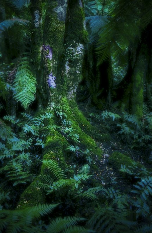
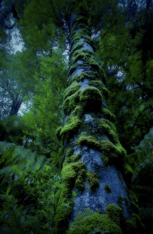
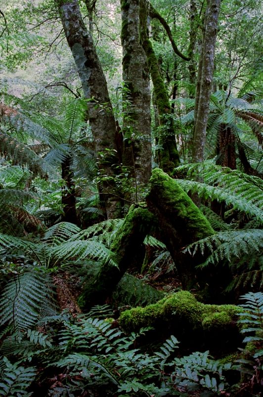
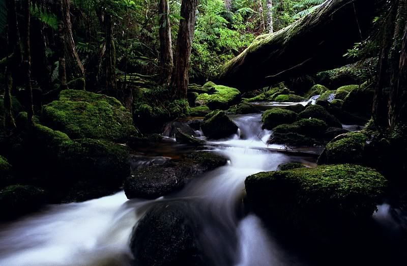
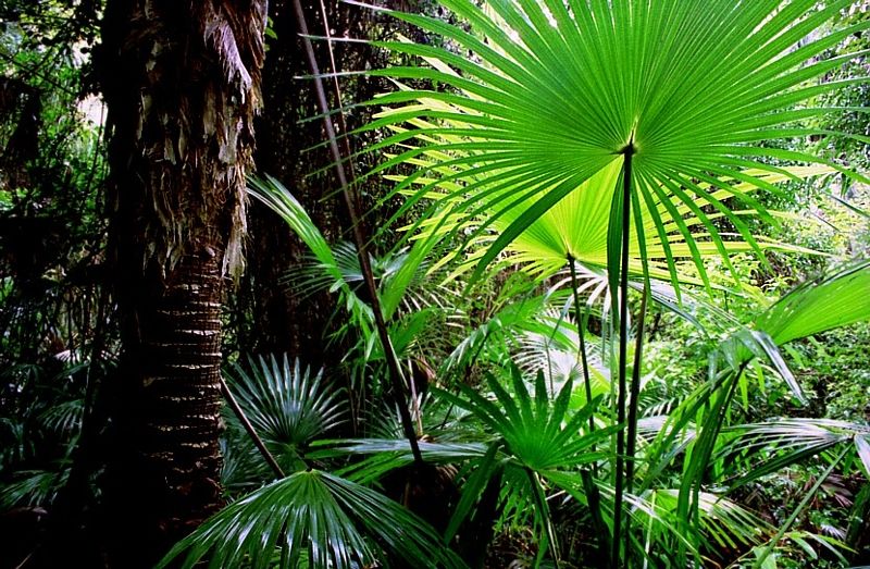
The photos are, Scented Sassafras, a giant Black Olive Berry and the 3rd image is Pinkwood, all on Errinundra Plateau relatively close to the Coast Range Road, east of Errinundra Saddle. The creek is Little Oakey Creek just before it flows over the Errinundra Escarpment and the last shot of the Cabbage Trees near Yeenung River, just off the Pacific Highway, East of Cabbage Tree Creek township.
jcr, The area from Thurra to Wigan including the Cicada Track is closed because of recent fires. No one from Parks Victoria knows at what stage the clean-up is at after the fire. I know that much.
What you have suggested for Croajingalong is one of the areas that I can't get solid info for, except that the area is temporarily closed. I haven't done the entire walk that you have mentioned. I've walked from the bridge over the Thurra River to Wigan Inlet and from Mallacoota south into the first of the giant sand hills.
The Gippsland Lakes I know well from the water. I race in the Marlay Point Race each year, which is the reason for my trip to Victoria. I've spent much time on the Gippsland Lakes, on and around Raymond Island and on the dunes of the 90 Mile Beach near Locks Port and Lakes Entrance.
The only other areas I've explored in East Gippsland are Little River Gorge (slightly), Errinundra Plateau (Errinundra I've been to often), Bemm River and the Snowy down past Marlo and along fire trails (mostly) in Indi and Byadbo. Any other recommendations would be really appreciated.
I've been through Omeo but I didn't stop because of bad weather. Where at Omeo would you suggest is interesting, to walk to?
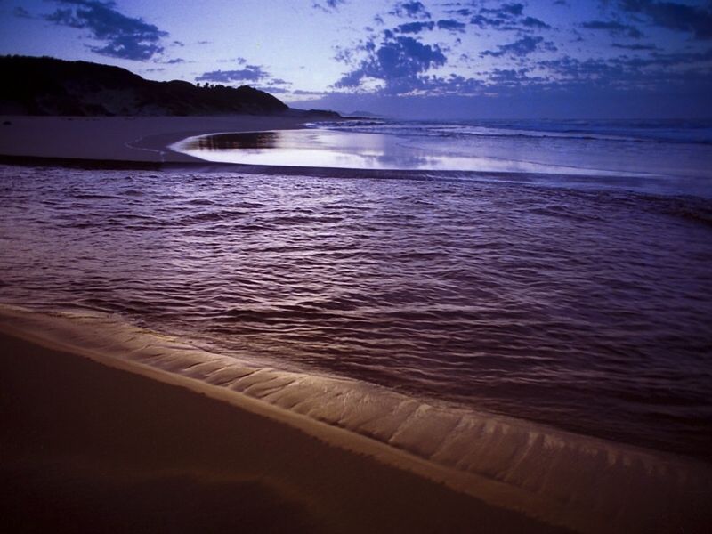
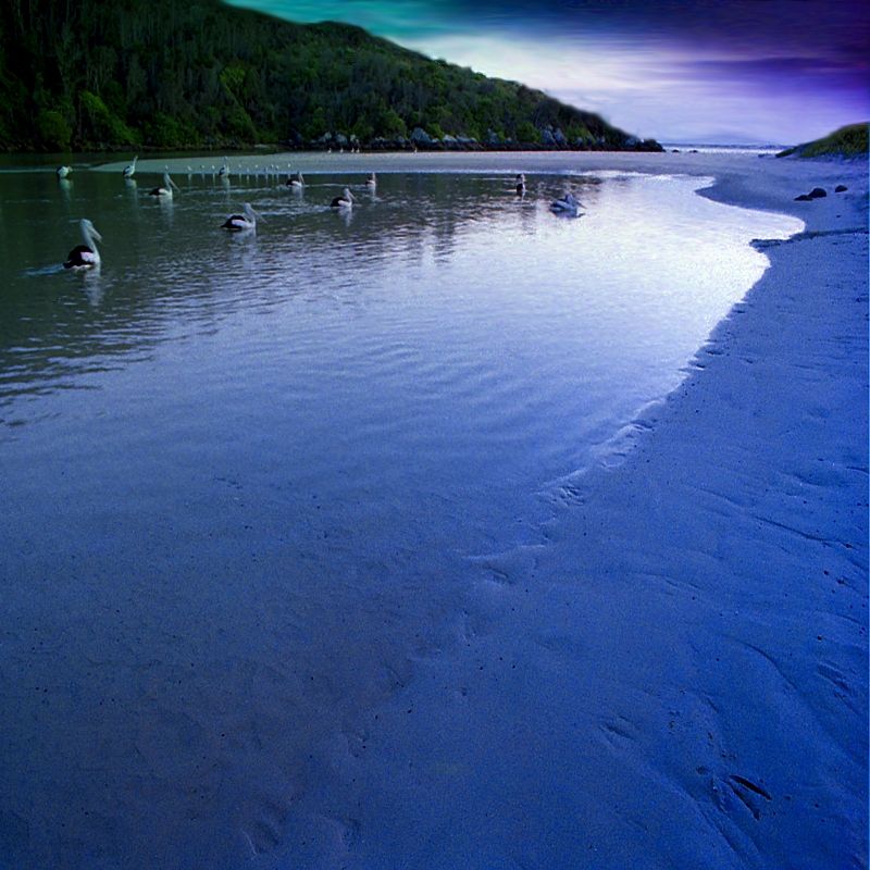
Images from my most recent trip to the Gippsland Lakes, during April last year.
'Up a Creek'. The Snowy River behind the dunes of the 90 Mile Beach, just before the Snowy runs out to sea. 2009.
'Portrait of Kangaroo Lake'. Dawn at Lake Reeve, 90 Mile Beach. 2009.
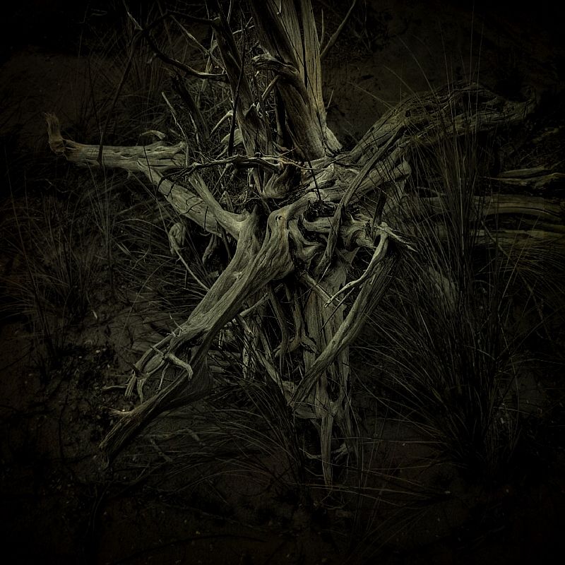
'Night Wood'. Driftwood on the back dunes of the 90 Mile Beach. Before dawn, Lake Victoria. 2009.
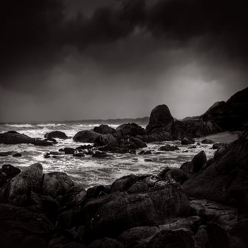
'Wilderness Within'. Stormy day on Victoria's wilderness coast. In the background is the eastern end of the 90 Mile Beach. 2009.
Warren.
The photos are, Scented Sassafras, a giant Black Olive Berry and the 3rd image is Pinkwood, all on Errinundra Plateau relatively close to the Coast Range Road, east of Errinundra Saddle. The creek is Little Oakey Creek just before it flows over the Errinundra Escarpment and the last shot of the Cabbage Trees near Yeenung River, just off the Pacific Highway, East of Cabbage Tree Creek township.
jcr, The area from Thurra to Wigan including the Cicada Track is closed because of recent fires. No one from Parks Victoria knows at what stage the clean-up is at after the fire. I know that much.
What you have suggested for Croajingalong is one of the areas that I can't get solid info for, except that the area is temporarily closed. I haven't done the entire walk that you have mentioned. I've walked from the bridge over the Thurra River to Wigan Inlet and from Mallacoota south into the first of the giant sand hills.
The Gippsland Lakes I know well from the water. I race in the Marlay Point Race each year, which is the reason for my trip to Victoria. I've spent much time on the Gippsland Lakes, on and around Raymond Island and on the dunes of the 90 Mile Beach near Locks Port and Lakes Entrance.
The only other areas I've explored in East Gippsland are Little River Gorge (slightly), Errinundra Plateau (Errinundra I've been to often), Bemm River and the Snowy down past Marlo and along fire trails (mostly) in Indi and Byadbo. Any other recommendations would be really appreciated.
I've been through Omeo but I didn't stop because of bad weather. Where at Omeo would you suggest is interesting, to walk to?
Images from my most recent trip to the Gippsland Lakes, during April last year.
'Up a Creek'. The Snowy River behind the dunes of the 90 Mile Beach, just before the Snowy runs out to sea. 2009.
'Portrait of Kangaroo Lake'. Dawn at Lake Reeve, 90 Mile Beach. 2009.
'Night Wood'. Driftwood on the back dunes of the 90 Mile Beach. Before dawn, Lake Victoria. 2009.
'Wilderness Within'. Stormy day on Victoria's wilderness coast. In the background is the eastern end of the 90 Mile Beach. 2009.
Warren.
Last edited by WarrenH on Wed 10 Feb, 2010 11:35 pm, edited 9 times in total.
- WarrenH
- Phyllocladus aspleniifolius
- Posts: 991
- Joined: Thu 07 Jan, 2010 6:54 pm
- Region: Australian Capital Territory
Re: East Gippsland
![]() by GerryDuke » Sun 07 Feb, 2010 6:52 pm
by GerryDuke » Sun 07 Feb, 2010 6:52 pm
Thanks Warren. I toured around the area a few years ago when working in Melbourne for a few months. Also drove the coast road to Sydney taking 3 days. Like you I found it very difficult to find any information on places to visit. It was a good trip for future visits. I set up my site for the same reason. I have included many maps where I have had time to show where places are! - http://www.touringtasmania.info.
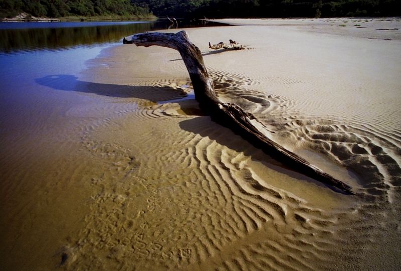
Love the picture of the dead tree. Looks like a skeleton of a horses head.
Gerry
Love the picture of the dead tree. Looks like a skeleton of a horses head.
Gerry
-
GerryDuke - Athrotaxis cupressoides
- Posts: 403
- Joined: Sun 18 May, 2008 12:04 am
- Location: KINGSTON BEACH, TASMANIA
- ASSOCIATED ORGANISATIONS: Operator of www.TouringTasmania.info web site
- Region: Tasmania
- Gender: Male
Re: East Gippsland
![]() by jcr_au » Sun 07 Feb, 2010 8:01 pm
by jcr_au » Sun 07 Feb, 2010 8:01 pm
Warren
Between Bairnsdale & Omeo there are areas to the west (Dodge City, Haunted Stream, Seldom seen) and to the east (Moscow Villa) has interesting walks on fire/forest tracks - walking on the tracks don't need much planning of course.
From Omeo you've got several sections of the AAWT. Davies High plain in accessible by 2wd in the dry months. Or camp at Native Dog Flat (or is it native cat flat - there's one of each and I forget which has the camp area) and walk from there
4wd gets you to McFarlanes Flat etc:
Or Thredbo is only 1 1/2hr north of Omeo, with only about 4km of High clearance required, thru Tom Groggin.
If you go towards Wulgulmerang instead of Omeo you've go the Snowy area near Suggan Buggan, or the Forests North & South of Tubbut are interesting - mainly on fire tracks again - arounf Tubbut its almost desert but 10km south its temperate rain forest
john r
John R
"I don't want to achieve immortality through my work.
I want to achieve immortality through not dying."
"I don't want to achieve immortality through my work.
I want to achieve immortality through not dying."
-
jcr_au - Athrotaxis cupressoides
- Posts: 172
- Joined: Sun 15 Nov, 2009 5:24 pm
- Location: Seymour
- Region: Victoria
- Gender: Male
Re: East Gippsland
![]() by volcboy » Mon 08 Feb, 2010 6:26 am
by volcboy » Mon 08 Feb, 2010 6:26 am
I climbed the Cobberas, just off the AAWT, about 2 years ago - you can drive in there via Suggan Buggan or via Omeo. There's a nice camp site about 5 minutes walk at Bulley Creek along the Cowombat Flat Track from where you park. 2WD access is fine. I drank the water from Bulley Creek without issue, but there are a lot of brumbys in the catchment, so be a little careful.
The walk to the peak of Cobberas Number One, Number Two, Cleft Peak and Moscow Peak is all off track through open woodland. To reach all four peaks is a moderate day walk.
There is also a good campsite at Limestone Creek nearby, although you'd need a 4WD to get down there (or a 1 hour walk).
You could extend the walk by going north across the border into NSW and climbing The Pilot and returning. The walking on the AAWT is all on fire trails in this area.
- volcboy
- Nothofagus gunnii

- Posts: 28
- Joined: Mon 19 Oct, 2009 7:27 pm
- Region: Tasmania
- Gender: Male
Re: East Gippsland
![]() by north-north-west » Tue 09 Feb, 2010 12:31 pm
by north-north-west » Tue 09 Feb, 2010 12:31 pm
It really depends on the type car, amount of driving, available time and type of walking you want.
From Omeo - assuming you're heading north from Bairnsdale (give my regards to Paynesville) - if you hang a left you're not far from Dinner Plains and Hotham, which gives you access to Feathertop, Loch, Swindlers Spur, Cobungra Gap etc or, in the other direction, that bit of the AAWT from St Bernard over The Twins and Wonnungurra to Murray, which is choice.
Or you can head up the Dargo from just west of Bairnsdale. A lot of wild country up there if you go that far, and the Mitchell River is on the way.
Or, turning right at Omeo, you can head up the Bogong High Plains or further up the highway to Mt Wills and the longest (and hardest) ascent of Bogong, via Long Spur. Or right again just 5km up the road, to Benambra, which leads to Limestone-Black Mountain Road, from which you can get onto sideroads for Buenba Flat and the Beroka Range, the Mt Hope Logging Road (Buckwong Creek, Mt Murphy, Davies Plain Ridge or through to Tom Groggin), Misery Trail (Davies Plain Ridge, again), Limestone Creek (hard walking, but a good run out to the Murray River), Cowombat Flat carpark, The Cobberas and the Playground; plus short walks to places like Wombargo or Stradbroke.
Also a lot of wild country in the Buchan Headwaters Wilderness, but I've not started my explorations there yet, so can't give any advice.
If you have the time, my choice would be to drive out to the Playground if you have a 4WD, or walk it if you don't (it's only an hour's easy walking to the start of it), cut up to the top of the ridge from the corner of Native Dog Creek, and over Cobberas No 1, Middle, Cleft, Moscow and Cobberas No 2, then follow the line of Mountain Trout Creek down to Cowombat Flat. Two days to do that and return via the Cowombat Track and the footpad across the ridge. If you have longer, up Cowombat Ridge, across the saddle to the Cowombat Track, up the Pilot and down its ridge to Forest Hill and the border cairn, then down to the spring that's the start of Indi Creek (and considered by many to be the start of the Murray although, technically, it isn't) and only a short walk back to Cowombat Flat and whichever route out you want.
The only issues would be whether there's water in Native Dog Creek (it's sometimes dry by the autumn), and the prickly nature of some of the scrub during the cross-country bits. It's largely open, dry forest up there, but I've never managed to get in a walk except the Cowombat Track without scoring a thorn or three in the fingers.
Actually, I'm a bit surprised you aren't familiar with that neck of the woods.
CDMA Suggan Buggan 1:50,000 covers the area.
"Mit der Dummheit kämpfen Götter selbst vergebens."
-

north-north-west - Lagarostrobos franklinii

- Posts: 15135
- Joined: Thu 14 May, 2009 7:36 pm
- Location: The Asylum
- ASSOCIATED ORGANISATIONS: Social Misfits Anonymous
- Region: Tasmania
Re: East Gippsland
![]() by WarrenH » Wed 10 Feb, 2010 6:31 pm
by WarrenH » Wed 10 Feb, 2010 6:31 pm
Thank you for the replies.
I've researched every suggestion and I've ordered a couple of maps for my collection.
I particularly like the Seldom Seen (Fords Road ) and Moscow Villa trips, for biking. There are a lot of high country huts in the immediate area. I've a love for high country huts, although Seldom Seen hut sounds like an old suburban house. Is this true?
I've done several walks north of Suggan Buggan into the Indi and Byadbo. Including the Charcoal Range and from Dead Horse Gap, south. Every walk I've done here has basically been from the Snowy going uphill and then back down again. I've not been west of the Ingeegoodbee River on foot.
The Playground to the Cobbras and Cleft Peak in particular (looks very interesting). This has been on the to-do list for a long time. Can I get into Native Dog Flat in a 2WD (a Volvo wagon) from the Snowy River Road?
In this region many of the roads are just rough dirt roads suitable for 2wd yet they are marked as 4WD only. Marking roads as 4WD is very misleading. The McKillops Bridge Road and the main approach to the Barry Way are called 4WD roads when they are far from it. Is this the trend with Victorian maps to dumb down the real road quality?
I received a map from Parks Vic today called 'Far East Gippsland Back Road Tour Guide' with nearly every road marked as AWD and 4WD suitable only routes. I've driven many of these roads in my 2WD and they are fine dirt roads. On the Map is written 'With new 4WD Classifications'. The roads are still the same roads as they were last year. Maybe the map should have written on it, 'With new Culture of Fear Classifications'.
Warren.
- WarrenH
- Phyllocladus aspleniifolius
- Posts: 991
- Joined: Thu 07 Jan, 2010 6:54 pm
- Region: Australian Capital Territory
Re: East Gippsland
![]() by volcboy » Wed 10 Feb, 2010 7:12 pm
by volcboy » Wed 10 Feb, 2010 7:12 pm
The Limestone-Black Mountain Road was fine when I drove in there 2 years ago from Benambra to the Snowy River Road. I was in a 4WD, but there were plenty of 2WD vehicles on the road. You should be able to get into Native Dog Flat in a Volvo wagon no problems, especially if it is an old school wagon with some clearance.
- volcboy
- Nothofagus gunnii
- Posts: 28
- Joined: Mon 19 Oct, 2009 7:27 pm
- Region: Tasmania
- Gender: Male
Re: East Gippsland
![]() by jcr_au » Wed 10 Feb, 2010 8:49 pm
by jcr_au » Wed 10 Feb, 2010 8:49 pm
Warren
North or south of the road at Tubbut is 4wd, bot not overly difficult.
Between the Barry Way & the Great Alpine Way I'd be struggling to think of any real 4wd roads.
West of the GAW there are some 4wd, but also a lot of 2wd roads
Black Mountain Rd from Benambra to Wulgulmerang is definitely 2wd, except when under snow.
I don't know the Seldom seen hut I'm afraid, but just to confuse you, there is a seldom seen west of Ensay, and another one east of ...Ensay
john r
John R
"I don't want to achieve immortality through my work.
I want to achieve immortality through not dying."
"I don't want to achieve immortality through my work.
I want to achieve immortality through not dying."
-
jcr_au - Athrotaxis cupressoides
- Posts: 172
- Joined: Sun 15 Nov, 2009 5:24 pm
- Location: Seymour
- Region: Victoria
- Gender: Male
Re: East Gippsland
![]() by WarrenH » Wed 10 Feb, 2010 11:09 pm
by WarrenH » Wed 10 Feb, 2010 11:09 pm
Thank you for the good advice about the roads. Good access is worth heaps.
I have a copy of 'Alpine Walking Track' by John Siseman 1988, I'll put more thought into sorting out the AAWT recommendations, for sure.
I know Seldom Seen via Wulgulmerang and some of the residents there.
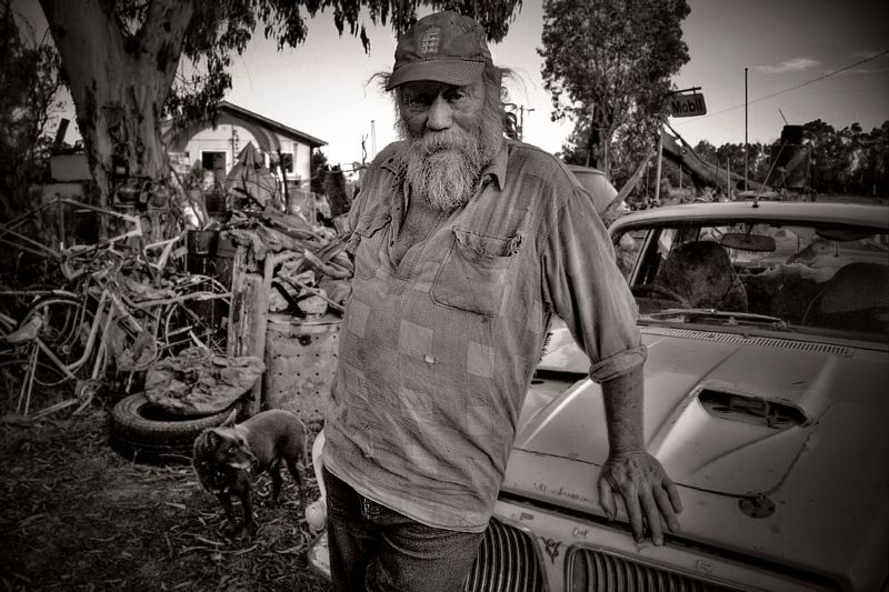
'Mobil Dave a Man from the Snowy River'. Seldom Seen Service Station. 2009.
'Smoky Byadbo'. Taken from the Gelantipy Plateau a few ks North of the servo, before the start of the descent to the Suggan Buggan River. 2009.
'Map to the Byadbo Wilderness' Digital photographic image. 2008. This is my favourite post-processed image from East Gippsland.
Warren.
I have a copy of 'Alpine Walking Track' by John Siseman 1988, I'll put more thought into sorting out the AAWT recommendations, for sure.
I know Seldom Seen via Wulgulmerang and some of the residents there.
'Mobil Dave a Man from the Snowy River'. Seldom Seen Service Station. 2009.
'Smoky Byadbo'. Taken from the Gelantipy Plateau a few ks North of the servo, before the start of the descent to the Suggan Buggan River. 2009.
'Map to the Byadbo Wilderness' Digital photographic image. 2008. This is my favourite post-processed image from East Gippsland.
Warren.
- WarrenH
- Phyllocladus aspleniifolius
- Posts: 991
- Joined: Thu 07 Jan, 2010 6:54 pm
- Region: Australian Capital Territory
Re: East Gippsland
![]() by north-north-west » Thu 11 Feb, 2010 12:19 pm
by north-north-west » Thu 11 Feb, 2010 12:19 pm
Most of the roads and many vehicle tracks are 2WD passable (if you're careful) with maybe an occasional nasty bit. Even the Cobberas Track into the Playground is almost doable, except for one steep rough bit on either side of a creek crossing - like that washout on the Mt Spec Rd, I refused to even try getting the old 2WD Hilux through that bit. Sometimes the only way to be sure whether you can drive in there is to try to drive in there.
But Limestone-Black Mountain Road is a good surface, no trouble for you, like the Suggan Buggan Road. Some good views there, too.
Enjoy.
ps: Nothing quite like a new map, is there?
But Limestone-Black Mountain Road is a good surface, no trouble for you, like the Suggan Buggan Road. Some good views there, too.
Enjoy.
ps: Nothing quite like a new map, is there?
"Mit der Dummheit kämpfen Götter selbst vergebens."
-
north-north-west - Lagarostrobos franklinii
- Posts: 15135
- Joined: Thu 14 May, 2009 7:36 pm
- Location: The Asylum
- ASSOCIATED ORGANISATIONS: Social Misfits Anonymous
- Region: Tasmania
Re: East Gippsland
![]() by karlylisette » Fri 12 Feb, 2010 11:10 am
by karlylisette » Fri 12 Feb, 2010 11:10 am
Hi Warren
I would suggest calling the Tourism Information Centre in Bairnsdale - they are very good, and if they don't know an answer, they will be able to point you in the right direction. Their number is (03) 5152 3444.
Also, the owners of Bairnsdale Camping and Outdoors, David and Wendy are a good resource as they are avid bushwalkers. Their number is 5153 1497.
The East Gippsland Rail Trail and the adjoining Discovery Trail are an easy ride and worth a look. The discovery trail is a nice contrast to the rail trail and takes you through temperate rainforest. You can ride from Bairnsdale to Orbost if so inclined but the Bruthen to Lakes trip is a bit of fun (and relatively easy).
The Rail Trail website is http://www.eastgippslandrailtrail.com/
Croajingalong National Park has beautifully maintained walking tracks and campsites that take you through to Cape Conran Nature Trail. Point Hicks and the sand dunes being the highlight.
Can you get up to the Alpine Park? There's plenty of walks around Omeo and up to Dinner Plain and Hotham.
McKillops Bridge access doesn't need 4WD (unless there's been heavy rain) but beware the heartstopping sheer drop!
Karly
- karlylisette
- Nothofagus cunninghamii

- Posts: 1
- Joined: Fri 12 Feb, 2010 11:00 am
- Region: Victoria
- Gender: Female
Re: East Gippsland
![]() by WarrenH » Fri 12 Feb, 2010 2:59 pm
by WarrenH » Fri 12 Feb, 2010 2:59 pm
Scavenger, too true Mate. That's If the maps aren't dumbed-down to cater for Wally World.
Karly, G'day.
"Where in the hell is McKillop's Bridge ?" was on a T-shirt once had. The swathe from Wulgumerong, across to Buldah, which includes Suggan Buggan, McKillop's Bridge, Deddick,Tubbut, Delicknora, Bendoc and Bonang, south to the Errinundra Plateau, I know well. I spent a couple of very happy months (in total) walking transects and doing tree surveys, and ripping along in Riparian forests and keeping cool in the beautiful Cool Temperate forests of Errinundra, on uni field trips. I'm a fan of big forests and how Errinundra used to be, before the severe fragmentation and its integrity was destroyed by logging.
My current bed time reading is 'Aspects of the Ecology Pertaining to the Population Structure and Community Dynamics of Podocarpus Lawrencii at Goonmerk Range, Errinundra Plateau, Victoria' by Philip C J Barker. Gunmark road to Goonmerk Rocks and along the Coast and Range Road, I could drive in my sleep if needed. Errinundra is a favourite place of mine, for sure. I can't wait to get back there and explore more of the Errinundra River.
I once broke down outside the 'Deddick Isolated Women's Group's meeting hall. It took me several days to find the time to get my car going. The cups of tea were nice. I like isolated places like McKillop's Bridge, I've several fond memories of that area.
The people from the Tourist Info at Bairnsdale have been excellent, I've had a few chats with them. They have been very prompt with posting mail. I'm now well set up with all that infra structure stuff.
Your suggestion of the East Gippsland rail trail is on my cards. I've done bits of that particular rail trail around Nowa Nowa. The Discovery branch looks good, and looks like a comfortable out and back, as a day ride.
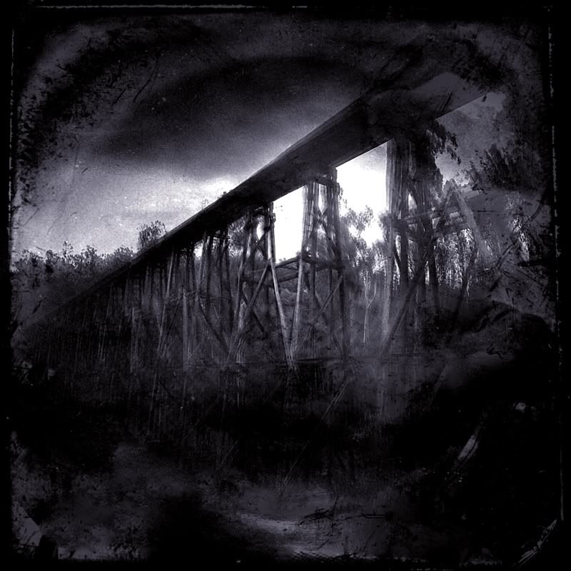
'Spin-out Bridge'. Stoke Creek(?), East of Nowa Nowa. Digital photographic image. 2009. A wooden bridge this big will spin most people out, I'm guessing. I saw a sign that said, Railway Crossing, so I hopped on my bike and expected to find a low level crossing in the forest. I didn't make it to the crossing, this giant bridge stopped me in my tracks. I thought that the McKillop's Bridge was impressive and hard to beat ... until I saw this bridge.
Warren.
Karly, G'day.
"Where in the hell is McKillop's Bridge ?" was on a T-shirt once had. The swathe from Wulgumerong, across to Buldah, which includes Suggan Buggan, McKillop's Bridge, Deddick,Tubbut, Delicknora, Bendoc and Bonang, south to the Errinundra Plateau, I know well. I spent a couple of very happy months (in total) walking transects and doing tree surveys, and ripping along in Riparian forests and keeping cool in the beautiful Cool Temperate forests of Errinundra, on uni field trips. I'm a fan of big forests and how Errinundra used to be, before the severe fragmentation and its integrity was destroyed by logging.
My current bed time reading is 'Aspects of the Ecology Pertaining to the Population Structure and Community Dynamics of Podocarpus Lawrencii at Goonmerk Range, Errinundra Plateau, Victoria' by Philip C J Barker. Gunmark road to Goonmerk Rocks and along the Coast and Range Road, I could drive in my sleep if needed. Errinundra is a favourite place of mine, for sure. I can't wait to get back there and explore more of the Errinundra River.
I once broke down outside the 'Deddick Isolated Women's Group's meeting hall. It took me several days to find the time to get my car going. The cups of tea were nice. I like isolated places like McKillop's Bridge, I've several fond memories of that area.
The people from the Tourist Info at Bairnsdale have been excellent, I've had a few chats with them. They have been very prompt with posting mail. I'm now well set up with all that infra structure stuff.
Your suggestion of the East Gippsland rail trail is on my cards. I've done bits of that particular rail trail around Nowa Nowa. The Discovery branch looks good, and looks like a comfortable out and back, as a day ride.
'Spin-out Bridge'. Stoke Creek(?), East of Nowa Nowa. Digital photographic image. 2009. A wooden bridge this big will spin most people out, I'm guessing. I saw a sign that said, Railway Crossing, so I hopped on my bike and expected to find a low level crossing in the forest. I didn't make it to the crossing, this giant bridge stopped me in my tracks. I thought that the McKillop's Bridge was impressive and hard to beat ... until I saw this bridge.
Warren.
- WarrenH
- Phyllocladus aspleniifolius
- Posts: 991
- Joined: Thu 07 Jan, 2010 6:54 pm
- Region: Australian Capital Territory
Re: East Gippsland
![]() by WarrenH » Sat 13 Feb, 2010 3:10 pm
by WarrenH » Sat 13 Feb, 2010 3:10 pm
A couple of East Gippsland rivers.
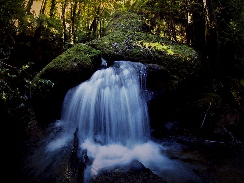
'Hairy Man Creek'. If I ever met the Hairy Man somewhere up this creek, I would say to him, "I'd like to compliment you on having a very nice creek Hairy Man."
'Do not Struggle Rainbow Serpent', the next flood will wash you out to sea. And it did. The pristine Thurra.
'Collecting Water', from the Thurra is best done upstream of the bridge nowadays. Once we could drink the water anywhere from the Thurra before it ran across the sand on its way down to the sea ... if the tide was out. In a Democracy, Wally World has the right to realise that, 'Healthy Parks Healthy People', means nothing and is a meaningless facile inanity ... but with Wally World's ignorance comes pollution based revenue. Keep the revenue rolling in ... it is improving the state's health at the expense of f'n the environment ?
Warren.
Last edited by WarrenH on Sat 13 Feb, 2010 11:36 pm, edited 2 times in total.
- WarrenH
- Phyllocladus aspleniifolius
- Posts: 991
- Joined: Thu 07 Jan, 2010 6:54 pm
- Region: Australian Capital Territory
Re: East Gippsland
![]() by jcr_au » Sat 13 Feb, 2010 5:57 pm
by jcr_au » Sat 13 Feb, 2010 5:57 pm
Warren
Great photos!
Whilst I've camped a bit at Wingan, I've only "travelled through" Thurra, but those shots make me want to go back and explore some more.
BTW where is Hairy man creek - looks enticing
john r
Great photos!
Whilst I've camped a bit at Wingan, I've only "travelled through" Thurra, but those shots make me want to go back and explore some more.
BTW where is Hairy man creek - looks enticing
john r
John R
"I don't want to achieve immortality through my work.
I want to achieve immortality through not dying."
"I don't want to achieve immortality through my work.
I want to achieve immortality through not dying."
-
jcr_au - Athrotaxis cupressoides
- Posts: 172
- Joined: Sun 15 Nov, 2009 5:24 pm
- Location: Seymour
- Region: Victoria
- Gender: Male
Re: East Gippsland
![]() by WarrenH » Sat 13 Feb, 2010 11:28 pm
by WarrenH » Sat 13 Feb, 2010 11:28 pm
jcr, thank you.
Hairy Man Creek is a tributary of the Errinundra River. The green track is the Misery Spur Track. The map is BENDOC 1:100.000
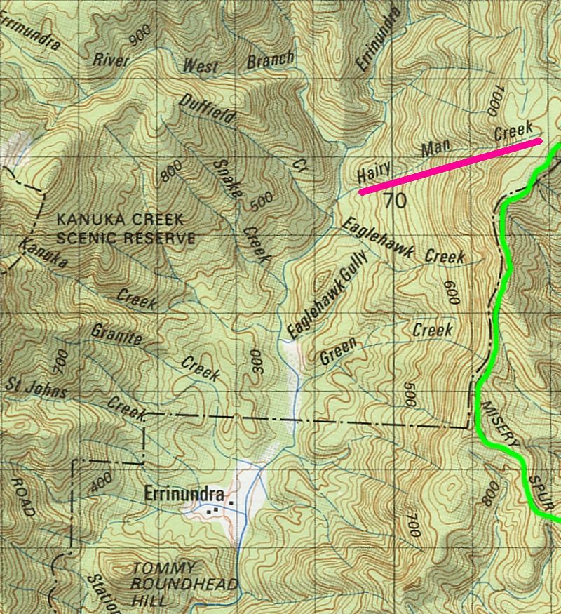
The Wilderness Coast.
Warren.
Hairy Man Creek is a tributary of the Errinundra River. The green track is the Misery Spur Track. The map is BENDOC 1:100.000
The Wilderness Coast.
Warren.
- WarrenH
- Phyllocladus aspleniifolius
- Posts: 991
- Joined: Thu 07 Jan, 2010 6:54 pm
- Region: Australian Capital Territory
Wild Wassa's washed-out wilderness wrong weekend.
![]() by WarrenH » Tue 09 Mar, 2010 5:40 am
by WarrenH » Tue 09 Mar, 2010 5:40 am
The last four days in East Gippsland were the worst four days I have ever spent ... weather-wise, insect-wise, almost humidity-wise and just for being totally drenched. I even slept drenched, totally. It took me 30 minutes to get out of saturated wet weather gear into dry clothes and then back into soaked wet weather gear, then only one minute later wishing I had more dry clothes, so that I could spend another 30 minutes squatting out of the rain changing clothes again, repeating, repeating, repeating the futile process.
I was listening to the ABC East Gippsland regional news yesterday, while sitting in the car about to head home, after pulling the plug on my soggy Victorian non-adventure, and the news reader said, "NE Victoria has had the heaviest rainfall ever recorded in Australia over a period of ...," which I missed because of a giant thunder clap. If that is the case, then I may have witnessed many drops of a record happening.
I remember what the term 'Murungower mud' means, again. It means grease, not mud ... and do not leave the tarmac without a good de-greaser like a strong handled desert spoon.
... but not ever have I experienced the mosquitoes that East Gippsland is currently plagued by. The locals that I talked to, not that there were many around in remote East Gippsland, all said, "The mosquitoes were shocking this season, unlike any other year," for some unknown reason. I even brought several mosquitoes home with me, I now find.
I'll continue my camping holiday in NSW now, now that I've returned home to dry everything that's needed for comfortable walking and to reduced chafing.
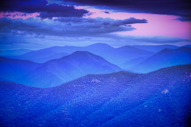
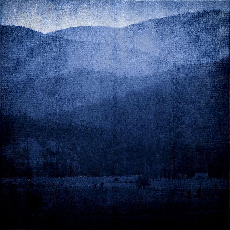
Two images from my trip. To quote Bob Dylan, "I've stumbled on the sides of 12 misty mountains" and glimpsed hints of regrowth after fire.
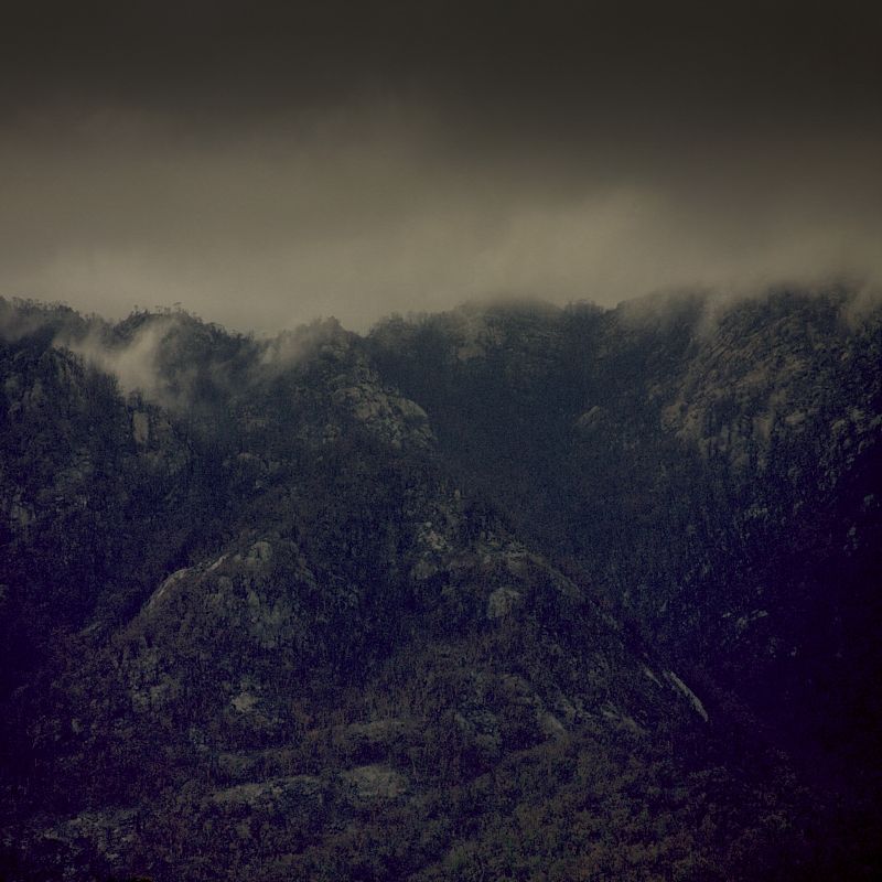
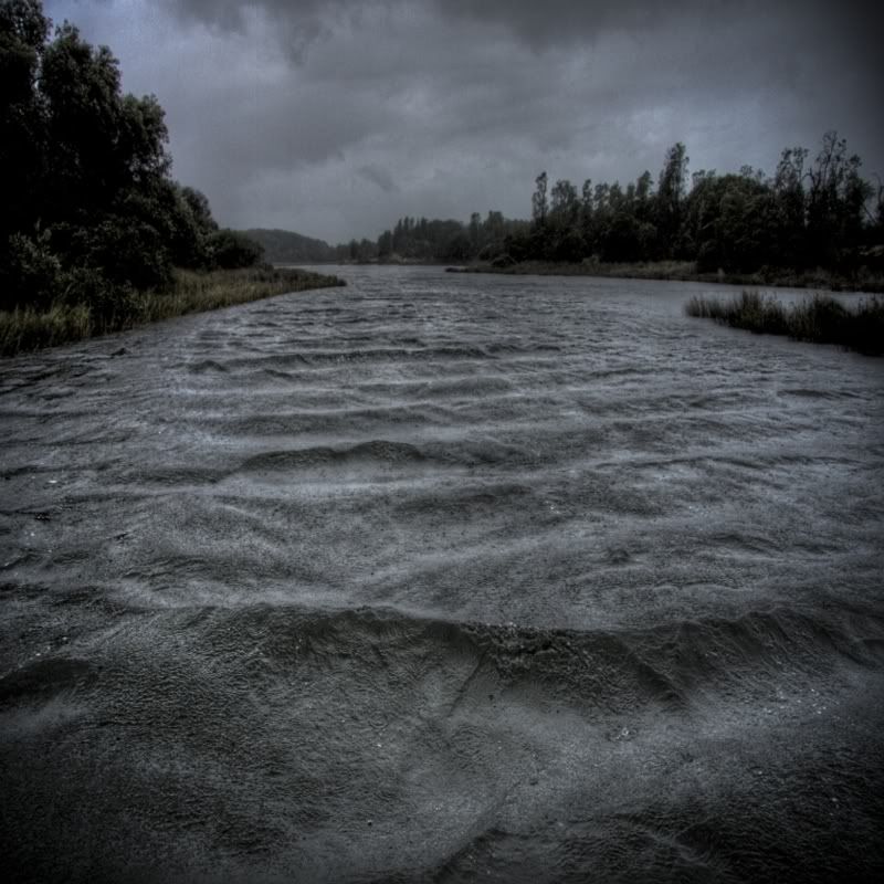
Storm clouds, good rain and much needed run-off. The rain is good for the environment for sure, but never-the-less shocking and effecting ... but very good to see. I'd pull-out of 100 thoroughly planned bushwalks to see that level of rain again. For sure. Just magic.
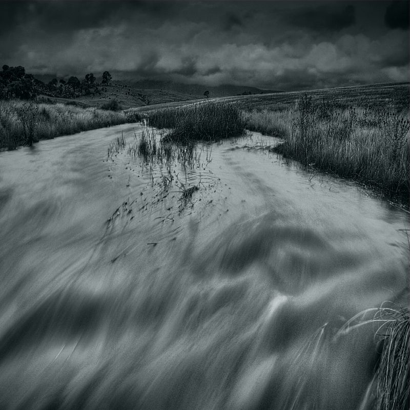
Warren.
I was listening to the ABC East Gippsland regional news yesterday, while sitting in the car about to head home, after pulling the plug on my soggy Victorian non-adventure, and the news reader said, "NE Victoria has had the heaviest rainfall ever recorded in Australia over a period of ...," which I missed because of a giant thunder clap. If that is the case, then I may have witnessed many drops of a record happening.
I remember what the term 'Murungower mud' means, again. It means grease, not mud ... and do not leave the tarmac without a good de-greaser like a strong handled desert spoon.
... but not ever have I experienced the mosquitoes that East Gippsland is currently plagued by. The locals that I talked to, not that there were many around in remote East Gippsland, all said, "The mosquitoes were shocking this season, unlike any other year," for some unknown reason. I even brought several mosquitoes home with me, I now find.
I'll continue my camping holiday in NSW now, now that I've returned home to dry everything that's needed for comfortable walking and to reduced chafing.
Two images from my trip. To quote Bob Dylan, "I've stumbled on the sides of 12 misty mountains" and glimpsed hints of regrowth after fire.
Storm clouds, good rain and much needed run-off. The rain is good for the environment for sure, but never-the-less shocking and effecting ... but very good to see. I'd pull-out of 100 thoroughly planned bushwalks to see that level of rain again. For sure. Just magic.
Warren.
Last edited by WarrenH on Fri 12 Mar, 2010 7:22 pm, edited 1 time in total.
- WarrenH
- Phyllocladus aspleniifolius
- Posts: 991
- Joined: Thu 07 Jan, 2010 6:54 pm
- Region: Australian Capital Territory
Re: East Gippsland
![]() by jcr_au » Tue 09 Mar, 2010 12:11 pm
by jcr_au » Tue 09 Mar, 2010 12:11 pm
Warren
You've obviously picked the worst possible weekend to go anywhere outdoors
I think the missing numbers of years from the radio was probably 120, at least thats what it appears to have been in the Goulburn Valley
my wife & I were asked, by a walking club we're members of, to organise a walk in the Traawool area (near Seymour) for last Sunday & I was watching the BOM weather radar from the time I got up until we had to leave & it looked like there was some really serious weather coming down from the north and we expected to get seriously wet.
Fortunately it was only drizzling at the start and cleared up completely by mid morning, with bright sunshine for the second half of our 15km ramble.
When we got home I checked the radar and the screen was just full of brilliant colours, but it seemed to slide away from Seymour - sounds like you must have drawn it your way - thanks for that
Seriously that would have been shocking to be out in, even in a tent. What a pity your weekend was wrecked, particularly after what would have been a reasonably significant drive
John R
"I don't want to achieve immortality through my work.
I want to achieve immortality through not dying."
"I don't want to achieve immortality through my work.
I want to achieve immortality through not dying."
-
jcr_au - Athrotaxis cupressoides
- Posts: 172
- Joined: Sun 15 Nov, 2009 5:24 pm
- Location: Seymour
- Region: Victoria
- Gender: Male
Re: East Gippsland
![]() by north-north-west » Tue 09 Mar, 2010 6:48 pm
by north-north-west » Tue 09 Mar, 2010 6:48 pm
Two superb images, Warren - where were they taken?
Sorry about the weather. Or should we blame you for it?
Saturday morning was fine. It wasn't until around 2:30 that it got wet. In fact, the rain started the minute I walked out of the door after finishing work . . .
I was prepared for the rain. And the fog. And the wind. But lightning when walking (and camping) on open mountaintops gives me the willies.
Still, I renewed my acquaintance with some old friends (Clear [it wasn't] and the King Billies) and scored a few new ones (Picture Point, Lovick, Timbertop) - gave the Nallo a thorough testing (if it can handle that sort of weather it can handle anything), and gained an even greater appreciation for my 4WD. So it wasn't a bad weekend, all in all. Even if it does mean yet another trip up Clear to try to get some photos . . .
"Mit der Dummheit kämpfen Götter selbst vergebens."
-
north-north-west - Lagarostrobos franklinii
- Posts: 15135
- Joined: Thu 14 May, 2009 7:36 pm
- Location: The Asylum
- ASSOCIATED ORGANISATIONS: Social Misfits Anonymous
- Region: Tasmania
Re: East Gippsland
![]() by WarrenH » Fri 12 Mar, 2010 6:54 pm
by WarrenH » Fri 12 Mar, 2010 6:54 pm
"You've obviously picked the worst possible weekend to go anywhere outdoors."- jcr_au.
I didn't pick the weekend sadly, I knew rain was coming but not to such an extreme level. The Marlay Point to Paynsville overnight race has been run for the last 42 years. I just turn up and do it when ever it is held. This is the first time that I've seen rain coinciding with the Marlay.
"Seriously that would have been shocking to be out in, even in a tent." -jcr_au.
I only take a light weight fly when I go away, if I'm away from the car, to save weight ... the mozzies each night were worse than the rain falling to biblical proportions, that I endured off and on for 3 and a half days.
"What a pity your weekend was wrecked, particularly after what would have been a reasonably significant drive." -jcr_au.
1300 ks is a significant drive, granted, but the hike and bike tour that I was intending to do, that I'd researched for the last 6 weeks, and failed to hardly start (this visit) was the greatest disappointment. There is always this time next year and I've now, finally, got all the maps.
I'm used to the great outdoors in East Gippsland. East Gippsland serves it up at times, to all levels imaginable. My old Trangia couldn't cope with the extreme humidity, it became very inefficient. I'm going to buy a Whisperlite burner this coming week.
Scavenger, thank you Mate. The shots are over the border in New South Wales in the Tinderry Range only 100 kilometres from home. I took the shots the first moment it stopped raining.
Warren.
- WarrenH
- Phyllocladus aspleniifolius
- Posts: 991
- Joined: Thu 07 Jan, 2010 6:54 pm
- Region: Australian Capital Territory
Re: East Gippsland
![]() by north-north-west » Mon 15 Mar, 2010 4:50 pm
by north-north-west » Mon 15 Mar, 2010 4:50 pm
The creek shot in particular is superb. I'm guessing the bank curves around just there, 'cause trying to stand in that little stream would be nothing short of suicidal.
btw, as far as maps go, if you want a good overview of how the roads and tracks connect, the Rooftop maps are great. Every edition is field checked, so the annotations on track conditions are spot on. Very useful.
btw, as far as maps go, if you want a good overview of how the roads and tracks connect, the Rooftop maps are great. Every edition is field checked, so the annotations on track conditions are spot on. Very useful.
"Mit der Dummheit kämpfen Götter selbst vergebens."
-
north-north-west - Lagarostrobos franklinii
- Posts: 15135
- Joined: Thu 14 May, 2009 7:36 pm
- Location: The Asylum
- ASSOCIATED ORGANISATIONS: Social Misfits Anonymous
- Region: Tasmania
Re: East Gippsland
![]() by WarrenH » Mon 22 Mar, 2010 6:11 pm
by WarrenH » Mon 22 Mar, 2010 6:11 pm
NNW, Son of Scavenger? ... thank you Mate.
Warren.
Warren.
- WarrenH
- Phyllocladus aspleniifolius
- Posts: 991
- Joined: Thu 07 Jan, 2010 6:54 pm
- Region: Australian Capital Territory
Re: East Gippsland
![]() by north-north-west » Mon 22 Mar, 2010 6:34 pm
by north-north-west » Mon 22 Mar, 2010 6:34 pm
Same person, though a clone would more accurately be called 'Daughter of . . . '
"Mit der Dummheit kämpfen Götter selbst vergebens."
-
north-north-west - Lagarostrobos franklinii
- Posts: 15135
- Joined: Thu 14 May, 2009 7:36 pm
- Location: The Asylum
- ASSOCIATED ORGANISATIONS: Social Misfits Anonymous
- Region: Tasmania
Re: East Gippsland
![]() by leaf » Fri 10 Mar, 2017 8:04 am
by leaf » Fri 10 Mar, 2017 8:04 am
Any recommendations for overnight walks in Errinundra National Park, please?
- leaf
- Nothofagus gunnii
- Posts: 16
- Joined: Thu 19 Dec, 2013 2:14 pm
- Region: Victoria
Re: East Gippsland
![]() by paidal_chalne_vala » Sat 11 Mar, 2017 5:22 pm
by paidal_chalne_vala » Sat 11 Mar, 2017 5:22 pm
Have you been up Genoa peak? That is a pleasant stroll. PV have an office in Cann River . They seem to deal with queries about Wingan Inlet and Thurra River.
- paidal_chalne_vala
- Lagarostrobos franklinii
- Posts: 2458
- Joined: Sun 22 Jan, 2012 10:30 pm
- ASSOCIATED ORGANISATIONS: VNPA.BTAC.Friends of Baw Baw.Mt.Bogong Club.
- Region: Victoria
- Gender: Male
28 posts
• Page 1 of 1
Who is online
Users browsing this forum: No registered users and 22 guests