Just wondering if anyone has been into this area of the main range recently? I'm hoping to walk from Cunninghams Gap out to Mt. Castle and back on the weekend. This thread seems to indicate it is fairly overgrown past Sylvesters Lookout viewtopic.php?f=48&t=5525&p=66368&hilit=castle#p66368
Is there anywhere to camp on Mt. Castle? DERM dosn't list a campsite to book there. Any advice would be appreciated. ta
Mt Castle (Main Range) and surrounding areas
Forum rules
Queensland specific bushwalking discussion. Please avoid publishing details of access to sensitive areas with no tracks.
Queensland specific bushwalking discussion. Please avoid publishing details of access to sensitive areas with no tracks.
35 posts
• Page 1 of 2 • 1, 2
Mt Castle (Main Range) and surrounding areas
![]() by cams » Mon 04 Jul, 2011 4:15 pm
by cams » Mon 04 Jul, 2011 4:15 pm
-
cams - Phyllocladus aspleniifolius

- Posts: 725
- Joined: Tue 24 Aug, 2010 1:54 pm
- Region: Tasmania
- Gender: Male
Re: Mt Castle (Main Range) and surrounding areas
![]() by isoma » Mon 04 Jul, 2011 7:06 pm
by isoma » Mon 04 Jul, 2011 7:06 pm
Hi cams,
Its been a while since I've been there but I cant imagine its changed much. There would be some great camp sites up on/around Mt Castle but I dont know how "official" they are.
As for the route between Castle and Cunninghams Gap its certainly not easy, but its not as bad as any offtrack walking in Lamington. Its doable as a day in both directions (it sounds like you're just planning the one night?) but would be very tiring and any navigational errors would see you spending an extra night out (the days are pretty short at the moment).
If you're with a group I'd suggest a more interesting trip, provided you have 2 cars for a shuttle, would be to ascend the range to Boars Head, visit Mt Castle and then set up camp somewhere along the range before it gets dark. You'd then have a shorter day out to Cunninghams the next day.
-

isoma - Athrotaxis cupressoides

- Posts: 295
- Joined: Wed 07 Oct, 2009 11:23 pm
- Location: Gold Coast
- Region: Queensland
- Gender: Male
Re: Mt Castle (Main Range) and surrounding areas
![]() by cams » Tue 05 Jul, 2011 1:05 pm
by cams » Tue 05 Jul, 2011 1:05 pm
Thanks isoma. Yeah, I'm on my own so was planning a fairly light and fast trip. See how I go. Will re-evaluate once I get to Laidley Creek Falls.
-
cams - Phyllocladus aspleniifolius
- Posts: 725
- Joined: Tue 24 Aug, 2010 1:54 pm
- Region: Tasmania
- Gender: Male
Re: Mt Castle (Main Range) and surrounding areas
![]() by Karlostavitch » Tue 05 Jul, 2011 1:23 pm
by Karlostavitch » Tue 05 Jul, 2011 1:23 pm
Hi Cams, I have hiked from Goomburra to Mt Castle twice in the last couple of years. Its a great hike with varying terrain. I camped right on top of Mt Castle, there is a cliff dropoff to the eastern side of the campsite (not sure if its registered as a campsite, but I would say that it is regulary used as such) so tie down your sleep walkers! The hike from Goomburra to Mt Castle took us about 4hrs.
Also I have heard if the winds are right, if you throw a teabag over the cliff from mt castle, that it will be returned to you because of the wind currents there. (I haven't tried that one yet).
Here are the track notes which were provided to me by a friend who knew the area. (If its wet the gate at Goomburra might be closed, although not sure if you will need to access the track from Goomburra if your going from cunninghams gap.
"
National Park info was hiding under the Environmental Protection Agency now Dept of Environment and Resource management and the number is 46661133. Unless the rain comes in over night, the gate should be open when you arrive. He was not willing to offer me a phone number of the local person who is the gate controller. I would suggest calling in at Cunninghams Gap ranger station which is approx 2-3 km west of Cunningham's Gap on your left on your way through.
The access point to Goomburra is 5 km south of Allora on the Twmba Warich highway although if you have a good map, I believe you can do a shortcut north to Dalrymple Ck Rd by turning off to the right somewhere after Cunninghams Gap. Either way you will note an old fashioned country Hall on the N/E corner of a crossroads. Regardless, take the eastern route and that will bring you to the NP ultiimately going past 'Gorden's county' a private camping affair. The road endpoints at the NP with a left fork crossing a small creek before heading up to the crest of the range through that blessed gate. If you follow this road to its end you will be at Mt Castle Lookout. Sylvester's lookout is approximately 3 km before the end of the road and your access point. 500m to the lookout then head north following a rough track which follows shortly down hill to a saddle and then a northern moderate ascent. As you approach the top of the track swings to the right and head east possibly 250m to an small rocky point which may be marked on your map as 'Sylvestors Lookout' with a dot. It is definitely worth having a look from here. You can spot the formal lookout below to the S/W. Conversely if you look up and N/E from the tourist lookout, you may see a rocky point at the top of a cliff to give you an idea of where you are heading. On back track 200m you will see better, an acute fork of the track again heading northish over rocky terrain and it too, will will be part of a further ascent and likewise you will drift from N to E as you reach the top of what is a shoulder that heads east then drops off to the escarpment. There are odd tracks that go nowhere easy so I would try to keep the cliff line within sight on your right as you traverse east at least for the topography becomes more clear. At the eastern end of this shoulder the track(s) descend N-N/E and naturally leads to a campsite just above Laidley Ck. I have mentioned that a natural spot for a cuppa is 50m further east on the rocky edge of the shoulder over looking Mt Castle (where we stopped for lunch that day – remember we had to head back up to the campsite and then climb down and around the falls) From the campsite head N down a short steep way crossing Laidley Ck and follow 50m to where the track slides steeply downhill around the cliff and then backtracks SSE under the falls. Near tragedy on the slippery rocks here so be careful. From there you simply follow the base of the cliff line to the hole in the wall; have a look. It is important to descend approx 10m from this point straight downhill and then continue E onto the razor back. The northern arm of the ridge back is too difficult for me to explain. The safest way is to diverge onto the western side and accept that you may have to have a backtrack of two. (On your return voyage you might try the eastern side as it is better but seems more precarious particularly if windy.) Once you get to the base of MtCastle cliffline head on the western side and stay close to the cliffline. It may take 15 minutes or so but as soon as you feel the ascent is safe, break off the traverse and climb straight up to the top of the spur and then hang a right to the very top. This is the Hilton and your mates should be fairly impressed. What is cool is that even in windy weather, the campsite is protected by eddy currents or something.
"
- Karlostavitch
- Nothofagus cunninghamii

- Posts: 9
- Joined: Tue 05 Jul, 2011 12:59 pm
- Region: Queensland
- Gender: Male
Re: Mt Castle (Main Range) and surrounding areas
![]() by isoma » Tue 05 Jul, 2011 3:43 pm
by isoma » Tue 05 Jul, 2011 3:43 pm
OK, sounds like fun. There is a campsite above those falls and to progress from there to Hole in the Wall/Boars Head etc you need to detour above the falls and then scramble down and go beneath the falls from the west. I wouldn't be game enough to attempt the scramble direct to HITW with a pack, though I believe its possible. This is stuff you've probably read or know already.
I dont think I've ever seen those falls with more than a trickle - perhaps a photo or 2 might be in order cams ? Good luck.
I dont think I've ever seen those falls with more than a trickle - perhaps a photo or 2 might be in order cams ? Good luck.
-
isoma - Athrotaxis cupressoides
- Posts: 295
- Joined: Wed 07 Oct, 2009 11:23 pm
- Location: Gold Coast
- Region: Queensland
- Gender: Male
Re: Mt Castle (Main Range) and surrounding areas
![]() by tas-man » Tue 05 Jul, 2011 11:35 pm
by tas-man » Tue 05 Jul, 2011 11:35 pm
Karlostavitch wrote:<snip> The northern arm of the ridge back is too difficult for me to explain. The safest way is to diverge onto the western side and accept that you may have to have a backtrack of two. (On your return voyage you might try the eastern side as it is better but seems more precarious particularly if windy.)<snip>
"
I can clearly remember a July 1972 weekend trip with BBW from Cordeaux to Castle where we struck severe westerlies coming over the ridge between Hole in the Wall and Boars Head and it was impossible to stand up. We resorted to crawling on hands and knees dragging packs behind us until we could safely get onto the Eastern side of the ridgeline at Boars Head. We also got showered with sago snow at the previous nights camp above the falls. I've got slides somewhere of that trip which will turn up some day when I am looking for something else
Last edited by tas-man on Wed 06 Jul, 2011 1:53 pm, edited 1 time in total.
"The world reveals itself to those who travel on foot."
Werner Herzog
Werner Herzog
-

tas-man - Athrotaxis selaginoides

- Posts: 1469
- Joined: Mon 03 Sep, 2007 8:55 pm
- Location: Riverside
- Region: Tasmania
- Gender: Male
Re: Mt Castle (Main Range) and surrounding areas
![]() by cams » Wed 06 Jul, 2011 9:46 am
by cams » Wed 06 Jul, 2011 9:46 am
Thanks for all the great notes everyone. Sounds like an adventure tas-man. Would love to see those photo's. What is sago snow though?
I think I might adjust my plans a bit though to be more like what you suggested isoma. Sounds like the Sylvesters Lookout to Mt. Castle is probably going to be the best bit so I don't want to miss out on that. I might get dropped off at Mt Castle and end up back at Cunninghams. Ascent to Boars Head is over private property isn't it?
I think I might adjust my plans a bit though to be more like what you suggested isoma. Sounds like the Sylvesters Lookout to Mt. Castle is probably going to be the best bit so I don't want to miss out on that. I might get dropped off at Mt Castle and end up back at Cunninghams. Ascent to Boars Head is over private property isn't it?
-
cams - Phyllocladus aspleniifolius
- Posts: 725
- Joined: Tue 24 Aug, 2010 1:54 pm
- Region: Tasmania
- Gender: Male
Re: Mt Castle (Main Range) and surrounding areas
![]() by Karlostavitch » Wed 06 Jul, 2011 10:07 am
by Karlostavitch » Wed 06 Jul, 2011 10:07 am
From how I see it, you might need a helicopter to get dropped off at Mt Castle.
I would recommend leaving the car at sylvestors lookout, hiking to hole in the wall and then Mt Castle, then spend the night there, then return the next day. (approx 4hrs hiking/day)
I couldn't really recommend any more adventurous routes because thats all I have done in that area.
I think sylvestors lookout is your closest drop point to Mt Castle (I could be wrong though).
- Karlostavitch
- Nothofagus cunninghamii
- Posts: 9
- Joined: Tue 05 Jul, 2011 12:59 pm
- Region: Queensland
- Gender: Male
Re: Mt Castle (Main Range) and surrounding areas
![]() by cams » Wed 06 Jul, 2011 11:12 am
by cams » Wed 06 Jul, 2011 11:12 am
Hmm. Well Bushpeople's describes a road that goes just about all the way to the top from the West and Take a Walk gives a description for getting to a car left on the road to the North-West. I don't really want to have to get all the way round to Goomburra.
-
cams - Phyllocladus aspleniifolius
- Posts: 725
- Joined: Tue 24 Aug, 2010 1:54 pm
- Region: Tasmania
- Gender: Male
Re: Mt Castle (Main Range) and surrounding areas
![]() by tas-man » Wed 06 Jul, 2011 1:13 pm
by tas-man » Wed 06 Jul, 2011 1:13 pm
cams wrote:Thanks for all the great notes everyone. Sounds like an adventure tas-man. Would love to see those photo's. What is sago snow though?
<snip>
The slides were not as hard to find as I had expected, so have scanned some. However due to their age (July 1972) and so many years in Queensland humidity, I had to clean off a bit of fungus. The discolouration in the last few I think were caused by the SLR being dropped on our scramble in the gale from Hole in the Wall, and so lost the last few slides to light exposure when the back popped open. I have darkened up the washed out areas to compensate.
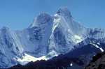
- View south to Mt Barney from Sylvesters Lookout.
- View north to Mt Castle from Sylvesters Lookout.
- Looking east to Moogerah Dam from another lookout further north along the range (Bare or Bald Rock?)
Last edited by tas-man on Wed 06 Jul, 2011 1:53 pm, edited 1 time in total.
"The world reveals itself to those who travel on foot."
Werner Herzog
Werner Herzog
-
tas-man - Athrotaxis selaginoides
- Posts: 1469
- Joined: Mon 03 Sep, 2007 8:55 pm
- Location: Riverside
- Region: Tasmania
- Gender: Male
Re: Mt Castle (Main Range) and surrounding areas
![]() by tas-man » Wed 06 Jul, 2011 1:27 pm
by tas-man » Wed 06 Jul, 2011 1:27 pm
A few more photos.
- Sago snow - soft fluffy hail, something in between hail and snow.
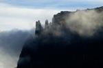
- The "Hole in the Wall"
- View south to Mt Barney through the Hole in the Wall.
"The world reveals itself to those who travel on foot."
Werner Herzog
Werner Herzog
-
tas-man - Athrotaxis selaginoides
- Posts: 1469
- Joined: Mon 03 Sep, 2007 8:55 pm
- Location: Riverside
- Region: Tasmania
- Gender: Male
Re: Mt Castle (Main Range) and surrounding areas
![]() by tas-man » Wed 06 Jul, 2011 1:32 pm
by tas-man » Wed 06 Jul, 2011 1:32 pm
Last photo.
- Looking through the Hole in the Wall further to the right of Barney to take in the entire profile of the Main Range.
"The world reveals itself to those who travel on foot."
Werner Herzog
Werner Herzog
-
tas-man - Athrotaxis selaginoides
- Posts: 1469
- Joined: Mon 03 Sep, 2007 8:55 pm
- Location: Riverside
- Region: Tasmania
- Gender: Male
Re: Mt Castle (Main Range) and surrounding areas
![]() by isoma » Wed 06 Jul, 2011 1:48 pm
by isoma » Wed 06 Jul, 2011 1:48 pm
Those photos turned out pretty good tasman - I especially like the first shot.
cams - those are 2 different "roads" that are being mentioned. The one from the west going to near the top is from the Laidley valley. You generally end up on it when heading to the summit of Castle after detouring off the ridge to bypass cliffs. I dont know if its possible to drive up there - I dont remember it being too bad (on foot) but I think the main obstacle is gaining access/permission from landowners further down the valley.
The other road originates at Goomburra and terminates on the Main Range escarpment where the Mistake Mountains merge. This one is driveable but i'm not sure if the gates are always locked/unlocked. There are a few walking tracks which branch off this road including one to Sylvesters. A (long) day trip I've been wanting to do for a while now is to ride up this road on mtb and then carry on along the Winder track , leaving the bike at the point where the route to Point Pure begins. Would be a very satisfying ride back to the car/camp.
As for the Boars Head route from the east - yes it is private property, but as far as I know there are no issues with access to the ridge on foot. Apparently you used to be able to drive in there somewhere (campsite no. 6), but this is no longer allowed. In any event, I've been in through there 4 or 5 times on both club and private walks and, to be honest, I'm not sure if anyone asked permission at any point. We did come across a landowner one time who just asked us to be sure to close the gates behind us.
-
isoma - Athrotaxis cupressoides
- Posts: 295
- Joined: Wed 07 Oct, 2009 11:23 pm
- Location: Gold Coast
- Region: Queensland
- Gender: Male
Re: Mt Castle (Main Range) and surrounding areas
![]() by isoma » Wed 06 Jul, 2011 1:53 pm
by isoma » Wed 06 Jul, 2011 1:53 pm
More photos while I was typing - excellent tasman, thanks.
-
isoma - Athrotaxis cupressoides
- Posts: 295
- Joined: Wed 07 Oct, 2009 11:23 pm
- Location: Gold Coast
- Region: Queensland
- Gender: Male
Re: Mt Castle (Main Range) and surrounding areas
![]() by cams » Fri 08 Jul, 2011 9:17 am
by cams » Fri 08 Jul, 2011 9:17 am
isoma wrote:Those photos turned out pretty good tasman - I especially like the first shot.
cams - those are 2 different "roads" that are being mentioned. The one from the west going to near the top is from the Laidley valley. You generally end up on it when heading to the summit of Castle after detouring off the ridge to bypass cliffs. I dont know if its possible to drive up there - I dont remember it being too bad (on foot) but I think the main obstacle is gaining access/permission from landowners further down the valley.
The other road originates at Goomburra and terminates on the Main Range escarpment where the Mistake Mountains merge. This one is driveable but i'm not sure if the gates are always locked/unlocked. There are a few walking tracks which branch off this road including one to Sylvesters. A (long) day trip I've been wanting to do for a while now is to ride up this road on mtb and then carry on along the Winder track , leaving the bike at the point where the route to Point Pure begins. Would be a very satisfying ride back to the car/camp.
As for the Boars Head route from the east - yes it is private property, but as far as I know there are no issues with access to the ridge on foot. Apparently you used to be able to drive in there somewhere (campsite no. 6), but this is no longer allowed. In any event, I've been in through there 4 or 5 times on both club and private walks and, to be honest, I'm not sure if anyone asked permission at any point. We did come across a landowner one time who just asked us to be sure to close the gates behind us.
Thanks. Yeah, I have been up that road from Goomburra and done the little Mt. Castle lookout walk. Well I'm just sticking to my original plan. I doubt I'll make it any further than the falls but that can be an adventure for another day. It's going to be a cold one.
-
cams - Phyllocladus aspleniifolius
- Posts: 725
- Joined: Tue 24 Aug, 2010 1:54 pm
- Region: Tasmania
- Gender: Male
Re: Mt Castle (Main Range) and surrounding areas
![]() by scockburn » Sat 09 Jul, 2011 1:27 pm
by scockburn » Sat 09 Jul, 2011 1:27 pm
Nice Pics Ian. I have some similar ones but 2010 version and they look similar but greener.
Thanks for these.
Thanks for these.
-
scockburn - Athrotaxis cupressoides
- Posts: 100
- Joined: Tue 22 Jan, 2008 6:41 pm
- Location: Brisbane
Re: Mt Castle (Main Range) and surrounding areas
![]() by cams » Mon 11 Jul, 2011 10:55 am
by cams » Mon 11 Jul, 2011 10:55 am
Thanks to all the advice in the thread. I had a fairly successful walk. Plans changed a bit half way through. Ahh the wonders of mobile phone communications. The section between Bare Rock and Sylvesters lookout was much harder than I expected (not sure what I expected really) so I decided I didn't want to go back that way on Sunday so asked my pickup very nicely if they'd detour in to Goomburra and pick me up somewhere along lookout road. Took about 10 hours to get from Cunninghams Gap to Laidley Ck Falls. Walked out to Hole in the Wall on Sunday morning then back to Sylvesters lookout and headed off down the road until my ride arrived. Don't regret doing it but next time I'll take Karlostavitch's advice and do Sylvesters Lookout to Mt. Castle and back.
Ended up just taking the direct route out to Hole in the Wall. There was a maze of foot pad's around Laidely ck falls and I wasted too much time trying to find the right one to take that route. Kind of glad I did in the end. Was pretty exciting scrambling along that ridge. Here's a few pics. Will put up more in my blog over the next few days.
You can see here the two bluffs where a bit of a down climb was needed (only 2 or 3 moves). Both were reasonbly well protected from big falls though. Apart from that there were a few other very narrow don't fall sections but there were hand holds galore. You know it's narrow when you can straddle the entire width of the ridge with your legs and use the bum slide technique.
Ended up just taking the direct route out to Hole in the Wall. There was a maze of foot pad's around Laidely ck falls and I wasted too much time trying to find the right one to take that route. Kind of glad I did in the end. Was pretty exciting scrambling along that ridge. Here's a few pics. Will put up more in my blog over the next few days.
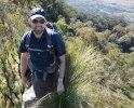
- Started early from Cunningham's Gap
- Ridge down to Hole in the Wall
You can see here the two bluffs where a bit of a down climb was needed (only 2 or 3 moves). Both were reasonbly well protected from big falls though. Apart from that there were a few other very narrow don't fall sections but there were hand holds galore. You know it's narrow when you can straddle the entire width of the ridge with your legs and use the bum slide technique.
- Laidley Valley through HITW
-
cams - Phyllocladus aspleniifolius
- Posts: 725
- Joined: Tue 24 Aug, 2010 1:54 pm
- Region: Tasmania
- Gender: Male
Re: Mt Castle (Main Range) and surrounding areas
![]() by tas-man » Thu 14 Jul, 2011 9:08 pm
by tas-man » Thu 14 Jul, 2011 9:08 pm
Thanks cams! Look forward to seeing more of your photos of this walk -please post a link to your blog photos when available.
"The world reveals itself to those who travel on foot."
Werner Herzog
Werner Herzog
-
tas-man - Athrotaxis selaginoides
- Posts: 1469
- Joined: Mon 03 Sep, 2007 8:55 pm
- Location: Riverside
- Region: Tasmania
- Gender: Male
Re: Mt Castle (Main Range) and surrounding areas
![]() by cams » Fri 15 Jul, 2011 9:50 am
by cams » Fri 15 Jul, 2011 9:50 am
I've put some more up on my blog http://hikinginseqld.blogspot.com/
I'm in the process of uploading a better quality version of the video.
You can click on the photo's to get the full size version. Good to do especially for the panoramas. It's interesting to note some of the regrowth of forest on the Eastern side of the range compared to your photo's tas-man. Good to see.
-
cams - Phyllocladus aspleniifolius
- Posts: 725
- Joined: Tue 24 Aug, 2010 1:54 pm
- Region: Tasmania
- Gender: Male
Re: Mt Castle (Main Range) and surrounding areas
![]() by tas-man » Fri 15 Jul, 2011 2:31 pm
by tas-man » Fri 15 Jul, 2011 2:31 pm
Great photos and trip report cams. The sound of the wind in your video brought back memories of my experiences there 
"The world reveals itself to those who travel on foot."
Werner Herzog
Werner Herzog
-
tas-man - Athrotaxis selaginoides
- Posts: 1469
- Joined: Mon 03 Sep, 2007 8:55 pm
- Location: Riverside
- Region: Tasmania
- Gender: Male
Re: Mt Castle (Main Range) and surrounding areas
![]() by cams » Wed 03 Aug, 2011 11:47 am
by cams » Wed 03 Aug, 2011 11:47 am
Got back out this way on Mon and Tues with my Brother. As recommended above this time we drove into Sylvesters and walked out to Mt. Castle, camped the night then headed back the way we'd come with a few slight variations. Mt. Castle campsite was really good.
- Tent Site on Mt. Castle
- Mist in the morning
-
cams - Phyllocladus aspleniifolius
- Posts: 725
- Joined: Tue 24 Aug, 2010 1:54 pm
- Region: Tasmania
- Gender: Male
Re: Mt Castle (Main Range) and surrounding areas
![]() by tas-man » Thu 04 Aug, 2011 12:46 am
by tas-man » Thu 04 Aug, 2011 12:46 am
Great pics cams - it wouldn't be a good campsite for a sleepwalker
"The world reveals itself to those who travel on foot."
Werner Herzog
Werner Herzog
-
tas-man - Athrotaxis selaginoides
- Posts: 1469
- Joined: Mon 03 Sep, 2007 8:55 pm
- Location: Riverside
- Region: Tasmania
- Gender: Male
Re: Mt Castle (Main Range) and surrounding areas
![]() by cams » Thu 04 Aug, 2011 9:39 am
by cams » Thu 04 Aug, 2011 9:39 am
tas-man wrote:Great pics cams - it wouldn't be a good campsite for a sleepwalker
Thanks. Yeah, I made my brother sleep on that side. I think you'd want to make yourself a leash or something if you were a sleep walker.
-
cams - Phyllocladus aspleniifolius
- Posts: 725
- Joined: Tue 24 Aug, 2010 1:54 pm
- Region: Tasmania
- Gender: Male
Re: Mt Castle (Main Range) and surrounding areas
![]() by gbagua » Fri 25 Oct, 2013 10:11 am
by gbagua » Fri 25 Oct, 2013 10:11 am
One quick question: Is it possible to leave the car at the bottom of Laidley Creek Falls, I mean is there a road access to there?
Alternatively, in the Take a Walk book the map indicates a "P" sign after Mt Castle, at the end of the track. I am not quite sure to how access that car park. Fixed (see note below).
My plan is to hike from this point to Mt Castle and then return in the same day, around 6h.
Cheers
Edit 1:
I found the following info:
Cunninghams Campsite No 6: This road is used to access the Mt Castle area via the steep south-eastern ridge of Boars Head. However, nowadays it is often difficult to obtain permission from the landowner to traverse the lands and it is very unlikely that camping would be allowed. To find the site, turn into Elizabeth Street in the centre of Aratula, just past the post office. Follow the road for 11km (passing Tarome State school on the right after 9½km), then turn left along a road signposted “Cunninghams Campsite No 6”. Pass through a gate, drive a further 2km, then turn hard right through an iron gate. From here, drive 500m along the fence to the campsite beside the creek. This last section is a dry weather road only.
From: http://www.southee.com/Bushwalking/Ch15 ... l#label016
This the same info that is given in Take a Walk under the heading "Where to leave your car shuffle vehicle." Just skip the indication about Tarome SS (closed down in 1992).
Edit 2: I will take this route instead of the painful drive to Sylvesters Lookout car park (80km drive vs 16km drive both from Aratula).
-
gbagua - Phyllocladus aspleniifolius
- Posts: 513
- Joined: Sat 20 Oct, 2012 9:04 pm
- Region: Queensland
Re: Mt Castle (Main Range) and surrounding areas
![]() by gbagua » Mon 28 Oct, 2013 6:59 am
by gbagua » Mon 28 Oct, 2013 6:59 am
cams wrote:You know it's narrow when you can straddle the entire width of the ridge with your legs and use the bum slide technique.
That's called cheating in my book. Nah, the leap of faith technique and blindfolded to spice things up a bit, only legs allowed.
The direct route from the Laidley Creek Falls lookout? to HITW was the best part of the hike. Very nice. I didn't know there was an alternative route. Can anyone give me some details, Laidley Creek Falls detour, is that it?
I ended up doing the Sylvesters to Mt Castle route instead of the Cunninghams camp 6 one as I had no info about it, unfortunately.
Cheers.
-
gbagua - Phyllocladus aspleniifolius
- Posts: 513
- Joined: Sat 20 Oct, 2012 9:04 pm
- Region: Queensland
Re: Mt Castle (Main Range) and surrounding areas
![]() by cams » Tue 29 Oct, 2013 9:00 am
by cams » Tue 29 Oct, 2013 9:00 am
gbagua wrote:cams wrote:You know it's narrow when you can straddle the entire width of the ridge with your legs and use the bum slide technique.
That's called cheating in my book. Nah, the leap of faith technique and blindfolded to spice things up a bit, only legs allowed.
The direct route from the Laidley Creek Falls lookout? to HITW was the best part of the hike. Very nice. I didn't know there was an alternative route. Can anyone give me some details, Laidley Creek Falls detour, is that it?
I ended up doing the Sylvesters to Mt Castle route instead of the Cunninghams camp 6 one as I had no info about it, unfortunately.
Cheers.
Take a walk describes the non-direct route. From the Laidley Ck Falls campsite you head towards the falls but detour left before heading too far along the creek. There are lots of footpads to follow so it is easier to find heading back up. You end up at the bottom of the falls then just following the bottom of the cliff/razorback along to HITW.
As you say though, if you've got the head for it the direct route is the best bit of that walk.
-
cams - Phyllocladus aspleniifolius
- Posts: 725
- Joined: Tue 24 Aug, 2010 1:54 pm
- Region: Tasmania
- Gender: Male
Re: Mt Castle (Main Range) and surrounding areas
![]() by gbagua » Thu 31 Oct, 2013 6:43 am
by gbagua » Thu 31 Oct, 2013 6:43 am
I didn't see any tracks to the falls themselves, I didn't even noticed where the falls were, unfortunately. The funny thing is that the direct route looked the most obvious one, for some reason.
Cheers.
Cheers.
-
gbagua - Phyllocladus aspleniifolius
- Posts: 513
- Joined: Sat 20 Oct, 2012 9:04 pm
- Region: Queensland
Re: Mt Castle (Main Range) and surrounding areas
![]() by ahmondjai » Fri 10 Jul, 2015 11:26 pm
by ahmondjai » Fri 10 Jul, 2015 11:26 pm
I'm planning to do a walk to Mt. Castle like what Cam did a few years back, does anybody know if a 2WD sedan could handle the road to Sylvesters Lookout?
- ahmondjai
- Atherosperma moschatum

- Posts: 57
- Joined: Sat 19 Jun, 2010 8:16 pm
- Region: Queensland
Re: Mt Castle (Main Range) and surrounding areas
![]() by ofuros » Sat 11 Jul, 2015 3:56 am
by ofuros » Sat 11 Jul, 2015 3:56 am
It's a 2wd drive in...just got to the watch the weather when going in & back out, as the river crossings can quickly rise if it rains heavily.
Mountain views are good for my soul...& getting to them is good for my waistline !
https://ofuros.exposure.co/
https://ofuros.exposure.co/
-
ofuros - Athrotaxis selaginoides
- Posts: 1932
- Joined: Fri 05 Feb, 2010 4:42 pm
- Region: Queensland
- Gender: Male
Re: Mt Castle (Main Range) and surrounding areas
![]() by ahmondjai » Tue 14 Jul, 2015 12:03 am
by ahmondjai » Tue 14 Jul, 2015 12:03 am
Thanks, Ofurs, time to get things organised and plan for a trip is underway.
Sent from my iPad using Tapatalk
Sent from my iPad using Tapatalk
- ahmondjai
- Atherosperma moschatum
- Posts: 57
- Joined: Sat 19 Jun, 2010 8:16 pm
- Region: Queensland
35 posts
• Page 1 of 2 • 1, 2
Who is online
Users browsing this forum: No registered users and 31 guests