This report is from a few months back, but people tend to be interested in Mt. Weld as somewhat of a lesser walked peak in the SW and hence people want info, so I thought I would share now that I have found a few minutes to type this up.
This walk was in Feb or March of this year, can't remember, but it was a nice early morning day in Hobart as we made our way down to the royal web of forestry roads that lead to the trail head. The navigation of the forestry roads was the hardest part of the day in my books. The network of roads is sure intimidating for new players, and the maps and Forestry services are poor at best. The Ables guide provides the best descriptions we could find of access, and if you follow the directions and distances they list there, you will most likely be fine.
We were caught out by a fallen sign at the junction of the South Weld Road and North Weld Road. We took off down the North Weld Road, got to the end of it, and proceeded to head down a taped trail we thought was the Mt. Weld track, soon to come to realise we were dropping way to many meters down and that we had made a critical error back in the car. We didnt mind, and were curious as to what this trail was and headed a little further to the delightful sight of the Weld River. We took in the river and then headed back up the 10 minute trail to the car, discussing where we must have gone wrong. We soon realised the error we made, and were at the proper trail head, marked with a totem pole of tape and a cairn.
The start of the trail is the most unpleasant of the day, with 3km of cutting grass to slice you silly if not careful. Don't be tempted to go without gaiters at the start (not sure why you would, but just in case...), as you will regret it within 100m of experiencing the power of a sharp strand of Gahnia grandis. Pant would have been a good choice also. As young and fit walkers, we got to the creek marking the end of the bulldozered section of the walk in just over an hour, and wasted no time in heading up the hill.
The forested lower slopes of Mt. Weld proved not to be a problem, and although very steep in sections, we made good speed with only our light day packs and quality banter. We saw many lyebirds which was nice and some mighty tall pandani reaching for the light at the top of the canopy. My old buddy Richy Scopia was awaiting me as we exited the rainforest zone and stormed into the subalpine environment (always a good feeling) and some concentration was required to follow the tapes through this area, as the vegetation is very thick and vision is low.
The moorland is reached soon after and dual false summits are seen from this point above and to the right of the trail. The Abels recommends 7 hours to reach this point, but if you are like us and are walkers that make haste, take very few pictures, if any, and eat on the move, you could be here in 3 if you desired. Many good camp sites exist on this moorland at about 950-1000 meters up.
The summit route is basically whatever you want to to be, but we allowed the R. scoparia to dictate our route, and we headed for a small but flowing stream south of the moorlands (draining the "unnamed but delightful tarn" into Lobster Lake below). From the unnamed tarn, which really is delightful, we climbed to the summit, which is a little further than you expect, with ease and enjoyed chilly but clear views. I can see this peak being much harder in winter with snow and mist, so you may want to become much more familiar with the maps and just getting in your head what should be where so to speak, as, like usual in summer, we were just making it up as we went along.
My favourite outlook was across to the east, where the Snowy Range dominates. This is one of my favourite and in my view underrated ranges in Tas, and well worth a visit if you want some nice "easy" off-track walking. Plus, who can resist the mighty and prestigious Wetpant Peak! The Jubilee Range always takes my fancy as well, with its buttongrass looking so appealing in the intermittent sun. Alas, if only buttongrass ever lived up to its promised fast and unhindered walking potential...
The walk back down the mountain was broken up with lunch (a few delicious salad rolls made at 5am that morning, some fruit and some choc). Two tiger snakes were seen in the cutting grass section on the way back, so take care in summer!
Overall, the peak never lived up to the hype we heard from other walkers and pseudowalkers about it being a "monster day trip" and "only for those who love pain" et cetera. Counting our false start with the heading to the Weld River early in the day, we spent about 8 hours on the trail and enjoyed it all. This was fast, but not overly strenuous, and the walk back was super quick. We spent about 20 minutes on the summit. Make what you want of this, but I would encourage you to try out this peak. The Weld awaits you.
Mt. Weld
Forum rules
Posting large/multiple images in this forum is OK. Please start topic titles with the name of the location or track.
For topics focussed on photos rather than the trip, please consider posting in the 'Gallery' forum instead.
This forum is for posting information about trips you have done, not for requesting information about a track or area.
12 posts
• Page 1 of 1
Mt. Weld
![]() by creeping_moses » Tue 29 May, 2012 8:35 pm
by creeping_moses » Tue 29 May, 2012 8:35 pm
- Attachments
-
- Climbing up the creek to the tarn below the (false) summit.
-
- Looking back towards the coast along the Weld Ridge
-
- The Snowy Range
-

creeping_moses - Athrotaxis cupressoides

- Posts: 232
- Joined: Wed 18 May, 2011 9:43 am
- Region: Tasmania
- Gender: Male
Re: Mt. Weld
![]() by stu » Wed 30 May, 2012 8:58 am
by stu » Wed 30 May, 2012 8:58 am
Nice one.
It's a lot quicker thyese days with all the traffic in recent history, particularly through the cutting grass section & the additional re-tagging of the climb through the forest.
I'd suggest you try Mt Bobs in a day or Clear Hill & The Thumbs or the Anne Circuit if you want a more strenuous day out
It's a lot quicker thyese days with all the traffic in recent history, particularly through the cutting grass section & the additional re-tagging of the climb through the forest.
I'd suggest you try Mt Bobs in a day or Clear Hill & The Thumbs or the Anne Circuit if you want a more strenuous day out
-

stu - Lagarostrobos franklinii

- Posts: 2174
- Joined: Fri 02 May, 2008 8:31 am
- Region: Tasmania
Re: Mt. Weld
![]() by creeping_moses » Wed 30 May, 2012 12:39 pm
by creeping_moses » Wed 30 May, 2012 12:39 pm
Good suggestions, Stu. I've done Mt.Anne circuit in a day, which was a long one and we did Mt.Bobs as a one night walk so we could get up The Boomerang and explore Bobs Knobs. That was a great walk in the height of summer. Clear Hill will be on the list! I reckon my longest day on the trails has been from The Moonlight Ridge on the Southern Ranges through to Low Camp just below PB, including mt. VC. That was a long day by all measures.
Next walk will be Wylds Craig and Shakespeare on a winters day I think.
Next walk will be Wylds Craig and Shakespeare on a winters day I think.
-
creeping_moses - Athrotaxis cupressoides
- Posts: 232
- Joined: Wed 18 May, 2011 9:43 am
- Region: Tasmania
- Gender: Male
Re: Mt. Weld
![]() by stu » Wed 30 May, 2012 12:46 pm
by stu » Wed 30 May, 2012 12:46 pm
Coincidence...may see you up at Shakespeare, i have it pencilled in for a winter overnighter as well.
A casual overnighter to Layatinnah Hill & Mt Oana this weekend, a good winter option & probably pretty easy walking.
Our longest day so far was Mt Leillateah, but mostly due to taking the wrong return route rather than retracing our steps...15 hours is a fair days work in anyones book I think
You should have a crack at Mt Shaula (WA's) with pazzar, I know he intends to go back & try it in a day some time...
-
stu - Lagarostrobos franklinii
- Posts: 2174
- Joined: Fri 02 May, 2008 8:31 am
- Region: Tasmania
Re: Mt. Weld
![]() by mjdalessa » Thu 31 May, 2012 7:52 pm
by mjdalessa » Thu 31 May, 2012 7:52 pm
creeping_moses wrote:
Overall, the peak never lived up to the hype we heard from other walkers and pseudowalkers about it being a "monster day trip" and "only for those who love pain" et cetera. Counting our false start with the heading to the Weld River early in the day, we spent about 8 hours on the trail and enjoyed it all. This was fast, but not overly strenuous, and the walk back was super quick.
Couldn't agree more. A few HWC members told me very similiar things to this: "only for those who love pain". The cutting grass section was over rated, all trampled but a little muddy. We did it in a comfortable 10hrs. That crystal cave sounds interesting.
Anyone know how to find the "Angel Falls" in the Weld Valley, not the Anne Lake Shelf?
A few more photos here, looks like you got better shots than me. viewtopic.php?f=9&t=8968
Recent Peaks: Snowy South, Ben Nevis, Victoria, Blackboy, Bastion
- mjdalessa
- Phyllocladus aspleniifolius

- Posts: 590
- Joined: Fri 06 Feb, 2009 10:28 am
- Region: Tasmania
Re: Mt. Weld
![]() by biggbird » Mon 04 Jun, 2012 8:13 pm
by biggbird » Mon 04 Jun, 2012 8:13 pm
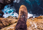
That person in the first picture... Alex? If so, I know why you guys had no trouble doing this, and have absolutely no illusions about my ability to do it in the same time/with the same ease 
- biggbird
- Phyllocladus aspleniifolius
- Posts: 776
- Joined: Wed 25 Apr, 2012 10:43 am
- Region: Tasmania
- Gender: Male
Re: Mt. Weld
![]() by creeping_moses » Tue 05 Jun, 2012 9:17 pm
by creeping_moses » Tue 05 Jun, 2012 9:17 pm
Correct, it is Alex, Alex. 
Having seen some of your walks on here, I reckon this walk would be one you could consider soon for sure. Obviously, only try for a day trip in summer. Having said that and having done the walk, I think camping at the nice moorlands would be the best way to go on this walk if you wanted a proper experience. Plenty of cool stuff to look at up there and the peak and ridge in general warrants much more than a few hours to explore if you want to do more than just get to the summit. A 2 day walk would be more enjoyable in many respects. Just dont expect good tracks (or any tracks towards the top), although as this peak gets more popular, its getting more trampled.
Has your brother told you about when I took him and another friend up Mt. Picton last winter? Running shoes in waist deep snow was only comical for a short time.
-
creeping_moses - Athrotaxis cupressoides
- Posts: 232
- Joined: Wed 18 May, 2011 9:43 am
- Region: Tasmania
- Gender: Male
Re: Mt. Weld
![]() by biggbird » Tue 05 Jun, 2012 9:59 pm
by biggbird » Tue 05 Jun, 2012 9:59 pm
Haha thought it might have been you Henry
Definitely will not feel bad if I can't do it in one day then, you two are both fitter than I'll ever be, and that's fine with me thanks
Yeah, you Jackson and togga went up, correct? Looked like a fun time from what I could see
So how many Abels are you up to by now then? Hope uni isn't cramping your style too much
- biggbird
- Phyllocladus aspleniifolius
- Posts: 776
- Joined: Wed 25 Apr, 2012 10:43 am
- Region: Tasmania
- Gender: Male
Re: Mt. Weld
![]() by creeping_moses » Wed 06 Jun, 2012 7:26 pm
by creeping_moses » Wed 06 Jun, 2012 7:26 pm
Yep was Togga, Jackson and I. That walk was much harder than I expected with the snow. Good fun though!
Not sure of my count exactly, but I've completed The South section, and nearly all of The South East and a good deal of The Mid-West section. Plus a fair few in the Cradle area, although I spend most of my walking time in the SW.
Uni is getting in the way big time! Havent been out on an overnighter since the year started which is way too long. Will be doing some big walks in the break after exams all being well. Shouldn't really complain about it without knowing what the clinical years are like though!
-
creeping_moses - Athrotaxis cupressoides
- Posts: 232
- Joined: Wed 18 May, 2011 9:43 am
- Region: Tasmania
- Gender: Male
Re: Mt. Weld
![]() by stepbystep » Wed 06 Jun, 2012 8:23 pm
by stepbystep » Wed 06 Jun, 2012 8:23 pm
Weld is the type of walk that needs to be taken with caution for a few reasons....
It's relatively long distance means if the weather goes to pot and navigation becomes difficult great care and experience are needed to make the right decisions.
If you have a more 'seasoned' body, dodgy knees or not in prime fitness it is a 12hr walk, so therefore not a winter daywalk option.
If inexperienced and you got lost in that forest section the result could be pretty drastic....
I took 10.5 hrs with an hour up top and more time exploring the area, I tend to travel reasonably quickly but stop to photo phaff(rest) often. I think 10-12 hrs is a realistic time for most moderately fit and experienced walkers.
Camping at the un-named tarn would be pretty good and there is a smaller one a little higher that would be even better
*&%$#! good effort doing it in the times you are though......
The idea of wilderness needs no defense, it only needs defenders ~ Edward Abbey
-
stepbystep - Lagarostrobos franklinii
- Posts: 7707
- Joined: Tue 19 May, 2009 10:19 am
- Location: Street urchin
- Region: Tasmania
- Gender: Male
Re: Mt. Weld
![]() by north-north-west » Wed 06 Jun, 2012 8:26 pm
by north-north-west » Wed 06 Jun, 2012 8:26 pm
*thinks* I used to be able to do that sort of speed over that sort of terrain. Ahhhh, the wonders of middle-age.
Definitely an overnighter for me.
Definitely an overnighter for me.
"Mit der Dummheit kämpfen Götter selbst vergebens."
-

north-north-west - Lagarostrobos franklinii
- Posts: 15148
- Joined: Thu 14 May, 2009 7:36 pm
- Location: The Asylum
- ASSOCIATED ORGANISATIONS: Social Misfits Anonymous
- Region: Tasmania
Re: Mt. Weld
![]() by biggbird » Thu 14 Jun, 2012 7:57 am
by biggbird » Thu 14 Jun, 2012 7:57 am
creeping_moses wrote:Yep was Togga, Jackson and I. That walk was much harder than I expected with the snow. Good fun though!
Not sure of my count exactly, but I've completed The South section, and nearly all of The South East and a good deal of The Mid-West section. Plus a fair few in the Cradle area, although I spend most of my walking time in the SW.
Uni is getting in the way big time! Havent been out on an overnighter since the year started which is way too long. Will be doing some big walks in the break after exams all being well. Shouldn't really complain about it without knowing what the clinical years are like though!
Haha yeah, I know the feeling! But trust me, 1st-3rd year are the worst in terms of time spent at uni really, especially as you probably are still learning to be a good skipper. Clinical years can be busy, but also far more fulfilling, and give you more opportunities to have time off! Too bad you have to go through years 1-3 first
- biggbird
- Phyllocladus aspleniifolius
- Posts: 776
- Joined: Wed 25 Apr, 2012 10:43 am
- Region: Tasmania
- Gender: Male
12 posts
• Page 1 of 1
Return to TAS Trip Reports & Track Notes
Who is online
Users browsing this forum: No registered users and 2 guests