Yesterday, Tortoise and I succeeded in reaching the top of the Gog Range. We tried last week (see this thread on the Gog viewtopic.php?f=3&t=5002&hilit=gog), but due to finding thick scrub and needing to walk along the road we didn't get there.
This time we got the key from FT with strict instructions to lock the gate behind us. Lo and behold, when we arrived at the gate it was open so we left it that way.
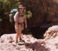
We took one car along to the eastern end (where rohjoe went up from), and left the other car at the start of the walk at Eel Holes Creek which the waterfall is on. This time we were able to follow the taped route fairly easily to the top of the range. It's a steep climb, and fairly slippery at the moment but certainly no cliffs! There are breaks in the trees where some good views can be had.
I managed to get a glimpse of a fairly awesome waterfall, but from the track only smaller drops can be seen. We might go back and try to get a view of the big fall.
Once on top of the range the taped route appears and disappears, but we usually managed to pick it back up eventually. We were keen to keep following it as it is a fair bit quicker than finding one's own route and we had daylight concerns. It would have been nice not to have been quite so rushed as the track is very pleasant, with good views here and there (when the cloud lifted), interesting outcrops of boulders with emerald green ferns and sphagnum moss, huge banksia trees, and one patch of bauera that the track completely disappears into! After shoving through a little way though, a dead tree has fallen to make a path through.
We were very happy to reach the dragon sign at just after 3pm, then followed the tapes along the top and down to below the cliffs. Part way down the tapes completely disappeared but had done the job of getting us easily through the cliffs so we just headed down through the bracken, reaching the road about 20m from the car thanks to the GPS.
This was an unexpectedly delightful walk and making it a through trip instead of a there and back worked very nicely. We took 6 hours, but it would have been more enjoyable if we'd had time to dawdle a bit without worrying about getting down an unknown route before dark.
We were very grateful to Bill Shepherd for the tapes as it would be a lot slower without them, and it is very reassuring following a taped route when you are in a bit of a hurry! They have disappeared in quite a few places but we were always able to pick them back up until we lost them below the cliffs. It's not a walk that I would recommend to anyone who isn't comfortable with their own navigation skills though.
Gog Range
Forum rules
Posting large/multiple images in this forum is OK. Please start topic titles with the name of the location or track.
For topics focussed on photos rather than the trip, please consider posting in the 'Gallery' forum instead.
This forum is for posting information about trips you have done, not for requesting information about a track or area.
1 post
• Page 1 of 1
Gog Range
![]() by Taurë-rana » Tue 28 Aug, 2012 12:48 pm
by Taurë-rana » Tue 28 Aug, 2012 12:48 pm
Peak bagging points: 170ish
Recent walks - Picton, Wylds Crag, Rogoona
Recent walks - Picton, Wylds Crag, Rogoona
-
Taurë-rana - Athrotaxis selaginoides

- Posts: 1031
- Joined: Mon 14 Jan, 2008 8:28 pm
- Location: Devonport
- Region: Tasmania
1 post
• Page 1 of 1
Return to TAS Trip Reports & Track Notes
Who is online
Users browsing this forum: No registered users and 3 guests