Forum rules
Posting large/multiple images in this forum is OK. Please start topic titles with the name of the location or track.For topics focussed on photos rather than the trip, please consider posting in the 'Gallery' forum instead.
This forum is for posting information about trips you have done, not for requesting information about a track or area.
Sprent
Wed 17 Apr, 2013 9:12 am
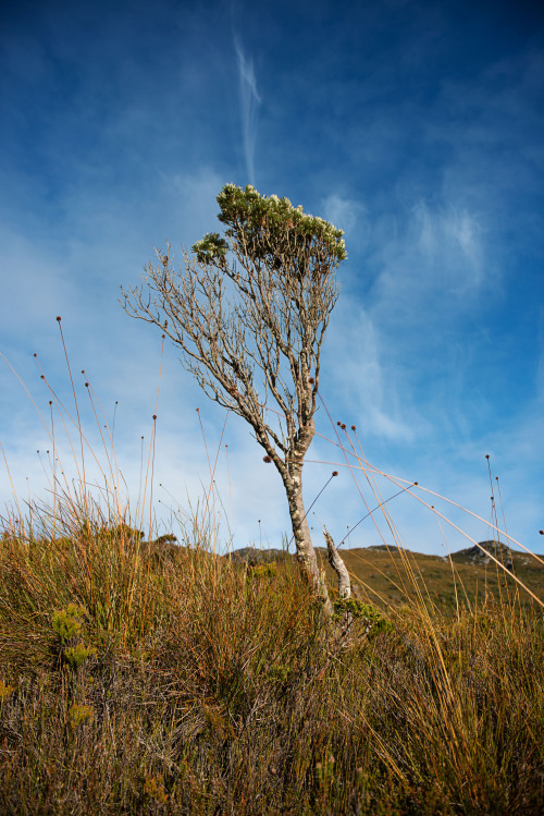
Another sunny autumn day in the SW! I enjoyed Mt Sprent very much, a relatively easy walk to a major SW viewpoint. My first time on the W side of Lake Pedder. Not quite quick enough for a Devonshire tea at the Possum shed on the return journey!
- Lake Pedder
- A subsidiary summit to be traversed around
- Attachments
-
- Climbing Heath
Re: Sprent
Wed 17 Apr, 2013 9:30 am
Lovely pictures! Haven't really looked into Sprent at all, how long was the walk? Difficult?
Thanks for sharing
Thanks for sharing
Re: Sprent
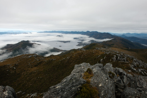
Wed 17 Apr, 2013 9:53 am
Nice walk hey tiger? No summit pic? It's one of the best value walks in the state, maybe 4 hrs return and very easy but steep bigbird.
This is what the view South is like from up top.
This is what the view South is like from up top.
- Attachments
-
Re: Sprent
Wed 17 Apr, 2013 9:57 am
Took me 4 1/2 hrs, the first section is very steep, but a clear track all the way, no boulder fields. Wonderful to see the ranges: WAs, Frankland, Mt Anne, Wedge, Spires and so on from a new perspective.
Re: Sprent
Wed 17 Apr, 2013 10:00 am
- The Franklands from the summit
Re: Sprent
Wed 17 Apr, 2013 10:14 am
I hear it's easy but quite overgrown. That's why it takes so long to do such a short distance, is this true ? This one is on my to-do list.
Re: Sprent
Wed 17 Apr, 2013 10:19 am
There are far more overgrown tracks than this, not too bad at all. I guess 700m of ascent takes time.
Re: Sprent
Wed 17 Apr, 2013 10:25 am
OK thx, then I don't quite understand why it's not in any daywalk book... Chapman only mentions it in his "SouthWest" book, and Tyrone Thomas refuses to write about walks in the SW or the Tarkine (stupid if you ask me).
Last edited by Hallu on Wed 17 Apr, 2013 10:31 am, edited 1 time in total.
Re: Sprent
Wed 17 Apr, 2013 10:31 am
Hallu wrote:OK thx, then I don't quite understand why it's note in any daywalk book... Chapman only mentions it in his "SouthWest" book, and Tyrone Thomas refuses to write about walks in the SW or the Tarkine (stupid if you ask me).
There are a number of high class, quite reasonable SW day walks that are not well publicised.
Sprent, the Sentinels, Wedge, the Needles, Clear Hill, and Schnells ridge for starters
Re: Sprent
Wed 17 Apr, 2013 10:36 am
Well some of them are off track, they're never gonna advertise off track day walks. But Mt Sprent should be, it's like one of the only things to do at the end of this road...
Re: Sprent
Wed 17 Apr, 2013 10:38 am
Hallu wrote:Well some of them are off track, they're never gonna advertise off track day walks. But Mt Sprent should be, it's like one of the only things to do at the end of this road...
Other than Shnells none of those mentioned are off track Hallu, then there's Mueller, Picton, Burgess etc etc etc
Re: Sprent
Wed 17 Apr, 2013 10:41 am
Even Schnells has a pretty reasonable pad up it.
Re: Sprent
Wed 17 Apr, 2013 10:59 am
OK my bad I though the Needles was off track. I should try it then.
Re: Sprent
Wed 17 Apr, 2013 2:21 pm
Is there anywhere near the top to pitch a tent? I guess there's no water close by?
Re: Sprent
Wed 17 Apr, 2013 3:23 pm
Stibb wrote:Is there anywhere near the top to pitch a tent? I guess there's no water close by?
I crossed a flowing stream around the 700m contour, I reckon you could find a campsite fairly close to the summit
Re: Sprent
Wed 17 Apr, 2013 3:24 pm
Hallu wrote:OK my bad I though the Needles was off track. I should try it then.
The Needles is maybe 2hrs return to the highest needle, the track is marked on the relevant 1:25000
Re: Sprent
Thu 30 May, 2013 8:32 am
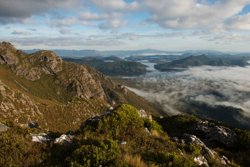
So after this discussion in here, and with a couple of days off, I headed down Sprentwards on Tuesday. Lucky to get some pretty decent weather, and some wonderful views!
Beautiful weather on the way up:
Bit cloudier at the top, but what a view!
Amazing being so close to the Franklands et al, my first real SW viewpoint. Now who wants to come and walk the Franklands with me at the end of the year?
Thanks for the inspiration Tigercat!
Beautiful weather on the way up:
Bit cloudier at the top, but what a view!
Amazing being so close to the Franklands et al, my first real SW viewpoint. Now who wants to come and walk the Franklands with me at the end of the year?
Thanks for the inspiration Tigercat!
Re: Sprent
Thu 30 May, 2013 8:53 am
Love the summit shot looking south bigbird. I have been thinking about The Franklands for a while now so next summer might be a go if the stars align 
Re: Sprent
Thu 30 May, 2013 9:25 am
Well, if you're free in mid November...
Re: Sprent
Thu 30 May, 2013 9:49 am
biggbird wrote:Well, if you're free in mid November...
Don't you lot leave any traces. I'll be through there in January
Re: Sprent
Thu 30 May, 2013 9:56 am
Haha you and a few others I hear. Will make sure to ruin all the good spots for you 
Re: Sprent
Thu 30 May, 2013 5:25 pm
biggbird wrote:Well, if you're free in mid November...
Hmmm.....
Re: Sprent
Thu 30 May, 2013 6:59 pm
Amazing being so close to the Franklands et al, my first real SW viewpoint. Now who wants to come and walk the Franklands with me at the end of the year?
Thanks for the inspiration Tigercat![/quote]
Glad you enjoyed it!
Thanks for the inspiration Tigercat![/quote]
Glad you enjoyed it!
Re: Sprent
Thu 30 May, 2013 8:41 pm
That low cloud/mist in your summit photo looks bizarre, Bigbird! Thanks for the posts regarding Sprent, looks to be a great mountain to take fit but first time bushwalkers for a bit of a taster. Always handy to have a few of these up the sleeve.
Re: Sprent
Thu 30 May, 2013 10:09 pm
That low cloud hung around the lakes (Pedder and Gordon) until at least mid-morning on both days. If I were smart enough, I'd explain why to you, but I'm not, so I'll just stick with saying it looked really cool
Definitely a good one for beginners, track was very easy to follow, and only just over ankle height mud! A couple of fallen/overgrown trees right at the start before the logbook, but apart from that, smooth sailing.
I'd also add the Sentinel Range to your list of beginner walks (for fit people, it's steep!). Again, easy to follow track, and great views from the top!
Said view:
(Not actually from the top, but from the false summit which is around 25m lower... but you get the idea )
Definitely a good one for beginners, track was very easy to follow, and only just over ankle height mud! A couple of fallen/overgrown trees right at the start before the logbook, but apart from that, smooth sailing.
I'd also add the Sentinel Range to your list of beginner walks (for fit people, it's steep!). Again, easy to follow track, and great views from the top!
Said view:
(Not actually from the top, but from the false summit which is around 25m lower... but you get the idea
Re: Sprent
Mon 03 Jul, 2017 7:01 pm
After finally getting some time off from Uni and work, (I.e. not working both weekend days) I decided to make the most of the nice weather with a pump out to the Southwest for a quick day trip. I had initial plans to do Mt Eliza but ended up settling on Mt Sprent as I’ll conjoin an Eliza/Anne trip later on. Recently ended up getting a new pack and wanted to use the trip to suss out how extended trips would be by loading it up with my winter gear and four days of food as a trial.
Driving in from Hobart during the morning was beautiful, as there was a nice layer of frost and morning fog throughout all of New Norfolk and most of the way into the Franklin-Gordon reserve. Was treated to a massive Wedge-Tailed Eagle flying along side the road shortly after Maydena and even more fortunate to see two more before getting to the Needle’s car park.
The trip up and back was fine, the vertical section was completely saturated however and each step easily sunk down to calf level. After hitting the open area, the clouds were holding somewhere over the POW Range and didn’t get too close to Sprent aside from the light drifting ones. There was a slight dusting of snow near the summit but it was more sporadic then anything. Took a quick break at the top and then headed back down. All in all, roundtrip was three hours and ten minutes.
Here’s some of the pictures from the walk, absolutely perfect day for it.
- Attachments
-
-
-
-
Re: Sprent
Wed 03 Jan, 2018 5:44 pm
Well after finding this thread recently, I decided to head up Sprent today. Weather forecast wasn't great , and I wasn't disappointed with a typical sw day. Windy, low cloud n misty drizzle. Still some nice wildflowers, a cool hanging big rock and breif glimpses of what lies beyond.
- Attachments
-
- Wildflowers
- m 1(1).JPG (337.32 KiB) Viewed 28427 times
-
- 'Hanging' rock
- m 4(1).JPG (464.71 KiB) Viewed 28427 times
-
- The view !!
- m 7(1).JPG (356.8 KiB) Viewed 28427 times
© Bushwalk Australia and contributors 2007-2013.