Yesterday the forecast for the last day of autumn was good so I decided to finally go for a walk out to Grey Mtn, on the Snug tiers behind Margate south of Hobart. I had put off doing this peak for some time as I knew it was a long walk on a 4wd track, not my favourite sort of outing. However I had also read that the views were excellent, so with a clear day forecast I bit the bullet and headed off. Access is via Van Morey's road which starts just past the school at the southern end of Margate, the road sign is however missing. Details of access can be found here.
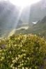
http://mhanna.customer.netspace.net.au/grey_mt.htm. I bailed a little earlier on the driving section at the first sign mentioning the Snug tiers recreational area (about 7.5km rather than 9km up Van Morey's rd having previously pulled the stone guard off the bottom of my low slung car on a similar track). In a car with reasonable ground clearance you would have no issue getting up to the parking area. From there it was a long walk on a rough 4wd track, plenty of loose rocks and mud holes but surrounded by pleasant woodland full of bird life. On the negative side there was a lot of crap on the trackside, bottles, cans and wrappers presumably thrown from 4wds by stupid people. It was quite brisk with ice remaining on the puddles until at least midday. I briefly took a wrong turn down the Pelverata falls track but then got back on the main route. From there it was wend your way up and down a few hills passing some mildly interesting things on the way. Who knew there was a button grass plain with peat bog up on the tiers? Finally I got to the locked gate which actually takes you up Grey Mtn and after about 15 minutes I was at the top, complete with comms towers, trig station and so on. A long somewhat boring walk of 11kms was rewarded by unbelievable views. I could see Pindars and La Perouse on the southern ranges, Adamsons, Esperance, Hartz, the Snowy range, Mt Anne, the Arthurs, Mt Field , Olympus and Ossa, and then north to the back of the Wellington range. Admittedly I had to wander around to get a few trees out of the field of view but this is a really unique vista.
On the way in I had been lucky, I had started about 9am and there were no 4wds to be seen or heard, on the way back I was not so lucky there were swarms of them, and the odd trail bike, which rather spoilt the serenity.
Overall it is a 2 out of 5 walk, reasonable scenery, amazing views on the right day marred by walking exclusively on roads shared at times by noisy metal things. It took me about 5 hrs including a 30 minute break at the summit, if you drove to the car park mentioned and did not detour I think you could take 30 minutes off that. Total distance about 23 kms. Summary, it would be great if there was a real walking track on Snug tiers, worthwhile if it is a clear day and you like distant views, and can overlook the man made pollution in all its forms.
BW
 Viewed 4591 times")
- A cold morning
 Viewed 4591 times")
- Button grass on Snug tiers
 Viewed 4591 times")
- Distant Views
 Viewed 4591 times")
- The long and winding road