PART 1
Well, this was a long time coming. Twenty-five years had passed since my first attempt at Mt Anne, which was stymied by wet and wild weather – as, sadly, were my other two attempts.
So when the opportunity came in December to go on a walk with a certain Mountain Leaper, and the forecast was favourable, this option kept nudging its way to the top of my list.
Concerned because I’d shrunk a little since that first attempt – though still technically avoiding dwarfism by nearly 5cm – of more concern was my increased fear of heights. Passing decades have compounded this problem, with my body no longer cooperating with my brain quite as well as it used to. In spite of all this, amidst fears of annoying the heck out of Mr seven-kilometres-an-hour Icefest, it would probably be my best shot at Anne and her circuit. So I was keen to give it a go.
With the forecast good for at least a couple of days, we set off mid- afternoon, aiming to camp high on the Eliza Plateau. But when threatening cloud began descending, we settled for the gingerbread-style High Camp hut. Great choice, as it rewarded us with front row seats for the sunset that would transfigure the evening sky.
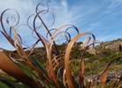
- 'Small'
- Sunset over Lake Pedder
Morning came with Eliza still in cloud, but she beckoned us up anyway. As we wouldn’t be racing up Anne that morning, we detoured to Eliza Bluff, who delighted us with sneak peeks at mystery mountains and plunging valleys.
Back en route to Anne, I found the boulder field on the plateau not nearly as tricky as I remembered. But of course it wasn’t pouring with rain this time. And my pack was a few kilos lighter. And I was now using poles.
Anne hadn’t shed her veil yet, but looked like she might emerge sometime soon. So we toddled on down to set up at Shelf Camp.
That’s where I’d stayed on my first aborted summit attempt – back then, mist curtains had hidden all but the few metres of ground around us. But now, as bit by bit the curtains were drawn open, it was as if I’d never been there before. By lunchtime, the clear dry conditions were ideal for attempting the summit, so we headed back up to face the challenge. My challenge was to get there and back; Mountain Leaper’s challenge was to help make that possible.
- Anne in Blue
As a result of the delay, along with my Tortoise pace and concern to get through The Notch in good weather, Pandani Shelf was put on hold for another trip.
[Love your photos of it by the way, Whynotwalk, and I’m looking forward very much to making its acquaintance one day.]
Now, I have heard – a number of times in fact – about an ‘easy’ way up to the summit of Anne. I’m told there’s a gully that’s ‘not airy at all’. Well, the picture I had in mind was rather like a giant Little Horn – a steep gully, plenty of things to hang onto, ‘not airy at all’ - forgetting that we obviously wouldn’t have the benefit of vegetation. And, of course, people’s definitions of ‘airy’ differ considerably.
But I definitely should have asked more questions, and made detailed notes, given my forgettory. Was it on the west side? Or was that the north side? Think it was the west… Well, here are some cairns – but are they heading for the gully or traversing around to Pandani Shelf?
As we sidled around the west side of Anne, keeping one eye out for cairns and the other eye out for possible gullies, we found some carefully stacked piles of stones that clearly headed into... Would you call this a gully?? Before long, our progress was halted by a bunch of very-airy-indeed rock walls. Voices of the couple, whom we had woken up in the hut that morning, unwittingly taunted us from eight metres or so above our heads. They’re on the summit! But…how on earth do we get from here to there???
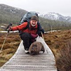
Somehow, bless his cotton socks, Mountain Leaper found a way, and with several timely hoiks, got me up too. (Reminder to self: Breathe, Tortoise, remember to breathe.)
Note to mountain leapers: Beware! If you very kindly offer to do a walk with one of us smidgets, just so you know what you might be in for: unlike chimpanzees, we have proportionately shorter arms. This limits our reach even more. Some little people are able to compensate for this with outstanding acrobatic skills and a good head for heights. Alas, some of us are not.
My relief was considerable when ML mentioned that his preferred descent route would be the ‘normal’ one, as “it couldn’t be any harder”. (Optimistic ponder to self: And might it even be slightly easier?)
I had visions of major celebrations if I ever got to the summit of Anne. An Irish jig perhaps, or triumphant whoops of joy. However, when the time finally came, after so many years, much trial and error, grunting and groaning, huffing and puffing, bruising and scraping, the looming vision of the descent totally eclipsed any feelings of jubilation. Even the whopping six peak-bagging points that our successful climb added to my total were not enough to rouse my enthusiasm.
“I left the rope in the tent”, commented Mountain Leaper.
I began to shake in my shoes, unsure if I had really heard the words, or if it was my fear succumbing to auditory hallucinations. (Aaaarrghh!)
Madame Smooth Summiter, who had apparently glided up the mountain with no need of a rope – though she looked like she’d just strolled through a park – sensibly suggested that I not think about it yet, and just enjoy the view. Hmmm. Yes, it would have been marvellous to be able to do that. (Breathe, Tortoise, remember to breathe.)
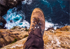
Thankfully, Monsieur Smooth Summiter had apparently forgiven us for disturbing them in the hut that morning. (We’d risen hours before them, and despite our tip-toeing efforts, had made plenty of unfortunate bangs and crashes.) He most graciously offered us the use of their rope. “We won’t need it going down”, he confidently assured us. Ok, breathing happening on its own now, no need of reminders. Token photos taken. ( Nice view. Thought I’d be over the moon. Ooooh that’s a long way dooooooowwnn!)
With a degree of trepidation (but it can’t be harder than the way we came up… Can it?), we let the gliders head off in front, following the cairn over the edge of the precipice. (See? Not so bad. Bit scary, but do-able.) Picked our way around the cliff, plenty to hold onto, okay so far. First ledge… (Oh, much wider than I expected. Nice! Oh, but it’s sloping the wrong way, down towards oblivion. Not so nice!)
Without going into too much graphic detail, I needed Mountain Leaper’s help to get down each of the shelves, with the rope for security on one of the little pitches. Unhappily, Mountain Leaper could not be both at the top with the rope, and at the bottom guiding this Tortoise's sometimes frantic search for the next solid foothold. But together we got me down, complete with colourful knees. And to my relief, it was easier than the way we’d gone up.
- Thanks, Nick S, for this shot - The Tricky Bit (our descent route)
Once down to the boulders, I began to revel in the brilliant views: enigmatic valleys, apparently innocent plains (which I knew may be concealing man-eating morasses of mud), and range after seemingly endless range of saw-toothed mountains. Some of the peaks were so familiar to me by name – having drooled over them on maps and been inspired by superb photos – but they had not yet become my friends. “I’m coming!”, I assured them hopefully.
‘Magic hour’ was still a good while off, but I decided to wait at the saddle anyway. Lake Pedder – such a controversial body of water, through no fault of her own – dominated the scene below. Saddened by her history, I still found her beautiful, showcasing the drama of the mountains around her. And the evening light show did not disappoint. What a privilege it is to be able to spend time in such magnificent country!
- Pandani, scoparia and Lot
PART 2
After a very different night on Shelf Camp from the one I remembered (this one allowed for a great deal more sleep), we awoke to light mist rolling in and out – but mainly out. Ahead of us stood our new challenge – the infamous Notch, then Mt Lot, Lightning Ridge – and the easier realms beyond.
- Toward the Notch
Oh, did I mention my less than optimistic thoughts the night before?
If truth be told, Mt Anne isn’t considered hard in serious bushwalking circles, though I’m not the only one to need a rope. But The Notch is considered a good challenge by a fair few peak-baggers. (So if I found Anne so Terrifying, what on earth was I thinking? The Notch is No Place for a Middle-aged Tortoise!)
Fortunately Mountain Leaper’s common sense broke through. “What – so you’re giving up without even trying?” Thank you, ML. That’s exactly what I needed.
So off we went, picking our way up to the next saddle, to head around the north side of the knoll, up and over and down into the Notch. Behind us, the sheer faces of Anne announced the fate that would have been ours if we hadn’t stuck to the rock the day before. But there we were, a lopsided but successful team, ready to face up to the next mountain.
Splashes of anemone-red waratahs vied for our attention with the much-appreciated blue sky, the myriad of peaks and the sapphire tarns below – which were looking anything but Lonely. Just stunning. Praise to the Master Craftsman welled up inside. “This is no accident!” my heart shouted.
Easing down into the Notch, I was greeted with a welcome surprise. It was much easier than I’d expected – the handy vegetation and the reasonable-despite-its-steepness track allowed for a descent relatively free of fear. Soothed into a guarded sense of security, I looked up the other side, and… well… it really didn’t look that bad.
- ML in the Notch
Of course, we investigated the ‘easier’ alternative out of the Notch. On closer inspection, we found that it would involve disappearing 60m down a near-vertical, unstable-looking scree, and madly traversing the ridiculous slope till we could find a way 80m back up. Well, it was a simple decision in the end.
My assessment of the first part of the climb out of the Notch was fair enough, but the top section had looked deceptively simple from below – for a Tortoise, at any rate. On tippy toes, I could get my armpits up to the rock that my feet needed to be on. But there was nothing left to push off with, and no footholds I could use – and there's the issue of the wimpy upper body... No way, José.
Having scampered ahead with the rope and secured it, giving me timely lessons on its proper usage, ML went exploring around to the west side.
“How are you on solid ramps?” (OK, I guess.) “It’s at about 60 degrees.” (Ah, a bit steeper than I’m used to.) But with no other choice than to quit, I edged around the cliffy bit, thankful for plenty of holds, reminding myself often to keep breathing.
- ML ascending the Notch
My usual method of attacking rock ramps involves momentum – but that was clearly inappropriate here. No leeway for slippage with that abyss below. (Hey, ML, couldn’t you have waited till AFTER the Notch before you told me about the guy who died there?? That’s my only beef.)
Thanks to a tutorial about making good handholds out of cracks in the rock, the provision of enough suitable stones to do so, and a very good hoik, I arrived safely at the top, with even more colourful knees. (At the top!! Whooo hoooo!!!)
The next challenge was to get both packs up, taking care not to damage ML’s spiffy ultralight job. Preparing to pop back down to attach the first of the packs to the rope, he stunned me with the news that I was the one who would have to haul them up. (If only I had gone lighter for this trip! What was I thinking? Remember, Tortoise, that you just need to cover your bases, not smother them. ) The problem was that there wasn’t much to hang on to, and as was the norm on this walk, the rock at the top sloped disconcertingly downwards towards the precipice. I found nothing to jam my foot against to brace for the weight of the packs. You may remember I mentioned a very wimpy upper body.
Fortunately my job was easier than I’d envisaged. ML easily hoiked the pack above his head while securing himself one-handedly. All I had to do was to take up the slack in the rope, and hold the weight of the pack till the next hoik. (Are these shoes going to stick well enough to the rock to hold me here?) You may remember that the rocks always sloped the wrong way. Sigh.
But once again, ML helped me reach the seemingly unattainable. My pack and I both made it safely up and out of the infamous Notch.
Life lesson for self: When the way ahead seems impossible, there may be an answer just around the corner. It may be scary; it may involve learning new skills and accepting the willing help of a Mountain Leaper. But it’s there. You just can’t see it from where you’re standing.
I knew I wasn’t entirely out of the woods yet, but a load had been lifted off my proverbial shoulders. We’d got up and down Mt Anne, and we’d got into and out of the Notch.
- Lake Judd and his Rock
Indeed, there were a few more awkward bits to negotiate before the top of Mt Lot, but nothing too scary. Easy-breathing views rewarded us on the summit, while Lightning Ridge’s knife-edge reminded me that I still needed to tread carefully on the way down. Three more peak-bagging points added to the tally.
Lots Wife, striking as she is, kept drawing my attention, but my speed – or lack thereof – would not allow time for even ML to scoot up. He graciously accepted this fact, and darted off for a swim in Lake Picone – the consolation prize. Meanwhile I basked in the late afternoon sun at Judds Charm, admiring the route that had led us down to the Lonely Tarns, and the changing colours of the mountains – and of my knees, as the polka dots began to coalesce.
As ML and I both enjoy elevated campsites, we made our respective ways up the next ridge to pitch our tents. It was here that we first stumbled upon the beautiful native iris, the purple star (isophysis tasmanica), which graced our paths over the next couple of days. Magical evening light. Great sense of achievement. No place I’d rather be.
PART 3
Next morning dawned beautifully clear, and we meandered up towards Sarah Jane. Angel Falls provided a side trip for ML, but they unfortunately fell short, so to speak, of the stunning drop at which the map had hinted.
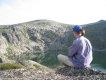
Meanwhile, I ensconsed myself on a high point, savouring the view of more Lonely Tarns, and the impressive ridge that could provide an adrenalin-pumping route to Sarah Jane’s summit. Not for me, though – not when there was a gentle way up. I’d like to keep using my knees for a good few years yet. Looking back from there, the problematic sections of the Anne circuit that we had managed to negotiate also looked suitably impressive. I felt a few centimetres taller.
During the amble and simple boulder-hop up to the summit of Sarah Jane, the three easy peak-bagging points seemed a little generous. But then we’d probably earned most of them by just getting to the turn-off. Points happily added to collection.
That afternoon, ML’s metaphorical Achilles’ heel kicked in. While the heat of the sunny afternoon didn’t bother me, it was clearly making the going tough for him. The cool waters of the Anne River far below inveigled him to keep pushing on. When we finally arrived there for lunch, it was 4pm. And I was whacked. In hindsight, I could easily have taken a break, joining ML later at the river. That never crossed my mind, though I know only too well that pressing on when I really need a sit-down stop seriously depletes my energy reserves for the day.
Thus after we crossed the soggy buttongrass plain and started up Schnells Ridge for a high camp – and a couple more points
I’d resorted to my weighty Mont Supertanker for this walk, worried that my lighter $1-from-the-tip-shop Berghaus might suffer catastrophic failure during the pack-hauling... And I’d doubted that my GoLite Pinnacle would be durable enough... And I’d been nervous that my Mountainsmith and ancient Sea to Summit packs may not be comfy enough… I was somewhat encouraged, however, by the fact that I could now use a medium pack cover on my Supertanker, instead of the large one I’d always needed in the past.
Further hampering my climb up Schnells were the extra few kilos of water I’d decided to carry for our potentially dry camp. (Gotta keep those bases well covered.)
Rugged views of the near-complete Mt Anne Circuit cheered up my frequent puff stops no end. But as our preferred campsite soared well above my reach, I was a little disappointed that ML would have to settle – though graciously as always – for second best. Despite it all, though, I was thrilled we’d been able to extend the walk for another day, and would have another room with a view.
When I finally dragged myself there, I managed to pitch my trusty shelter before satisfying my craving for horizontalness. I dozed in my tent while ML went off exploring. Later he convinced me to follow him up the small ridge that would add the west to my panorama. “Just up there” he reassured me. While I thought I’d found a second zephyr for this little amble, it was in fact only a breath of wind. Thus I struggled – though now packless – up the small ridge, seeking the reward of the Frankland Range silhouetted against the fading sunset. As always, it was worth the effort, and I returned contentedly to my home away from home.
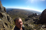
- Anne Circuit from Schnells Ridge
Next morning, cloud loomed low over our ridge. We knew that the craggy Arthurs, Federation Peak, Precipitous Bluff and their many neighbours would probably also remain bashful that day. Nevertheless, being faithful peak-baggers, we headed up in search of the ‘tippy top’ to claim our points.
For as long as I can remember, I’ve loved being on top of mountains. But I’ve only recently been converted to this possibly crazy but very satisfying pursuit. It has taken me to some Tasmanian jewels, large and small, that I never would have encountered otherwise.
Having decided that we’d been on all possible high points on Schnells Ridge in the mist, we headed back to our packs and on down towards the flat lands once more. Beautiful walking down the ridge. As the clouds behind us lifted, revealing clear peaks high above, we contemplated a return to the summit, this time to catch the views. But nah, perhaps not. We’d already had a veritable feast.
Back on the main drag, we were particularly glad to have taken the high road along Schnells. But still there were lovely sights to enjoy, like the tracts of swamp melaleuca, their copious little bursts of purple painting the buttongrass plain.
Heading back to the shuffled car, I ruminated over some options for our next walk, bearing in mind the dodgy forecast, my acrophobia and my very limited capacity to wade through any chest-deep mud (which would barely reach ML’s waist). But above all, I was simply grateful to have encountered such fantastic weather in south-west Tassie at last, to have witnessed the regal Anne in all her glory, and to have finally achieved my goal of reaching her crown. And, of course, to have added 14 points to my modest total.
Epilogue:
In light of my now juicy taste of success, I’ve revised my lifetime goal for bagging Tasmanian peaks. No longer content to reach ‘Honourable Peak-Bagger’ status, with a minimum 200 points, I’m now shooting for the more ambitious 400 points to become a ‘Peak-Bagger Extraordinaire’.
Day dreaming of Federation Peak – which fell off my bucket list years ago and sneaks back on in optimistic moments – I’m reminded that Anne should be fairly easy for those who make Fedders.
But hey, the door is open a smidgen, and for now at least, my little toe is making sure it stays it that way.