South West Cape Circuit

Trip reports, stories, track notes. Multiple/large photos are OK in this forum.
Forum rules
Posting large/multiple images in this forum is OK. Please start topic titles with the name of the location or track.

For topics focussed on photos rather than the trip, please consider posting in the 'Gallery' forum instead.

This forum is for posting information about trips you have done, not for requesting information about a track or area.

South West Cape Circuit

Postby kayoz » Tue 21 Feb, 2017 4:19 pm

SWC1.jpg
day 1
We have just completed this circuit, taking eight days. (clockwise)

Not too bad until after Wilson's Bight(second camp site better at WB -round the corner from the stairs ((watch out for stinging nettle)). Then things get a bit more difficult.

From here on the "track" is very overgrown and in many places requires an extra effort to push through (head high growth & above in places) and can easy be confused with wombat runs in many places.

It is best to keep checking compass and gps when traversing SW cape range(no signs or markings), also track notes in well known publication are somewhat misleading, the scrub traversing requires to get down on hands and knees climb over and find alternate routes, ideally a gps with many waypoints would be best to navigate with.

Also there are currently some confusing pink tapes at the the creek crossing inland from faults (faulls?) bay which we believe need to be ignored and a right turn should be taken when ascending out of a creek ravine and being presented with a left or right option.

The well known publication also suggests the rocky coast as an approach to the Noyhemer beach camp, we found this unrealistic due to swell and tide and didn't pack rock climbing equipment, so a significant scrub bash was required.

The side trip to Stephens Bay recommends a traverse over the headland meandering through the light scrub, this is very thick and near impossible to penetrate, the sand dune blow out is the best easiest option, but also requires a bit of scrub bashing but is far more doable and shorter than the headland option, GO BY THE DUNES!!! (the middens are a marvel at Stephens Bay)

When leaving Noyhemer beach navigation is essential to make sure you head for the correct crossing point of SW cape range it is easy to be lead too far north by the "track" (wombat runs abound)(there are no markings or signs once you're clear of the beach forest)

When descending down the Pascoe range approaching Horseshoe inlet the "track" dissipates and it is a make your own way to the edge of the inlet(scrub bash), the easiest option is to wade the whole way to the last beach where the camp is, (garbage bag required for swim(s) across creek mouth) (encase pack within) Scrub bashing is not a viable option. (be very careful of the rocky outcrops on the final point before the camp! they drop off deep and have razor sharp edges)(ouch)

A look through the log book at Noyhemer beach indicates about 13 groups or individuals pass through per year, so this explains the undefined "track"

& of course the Port Davey track to Melaleuca from Horseshoe is a bog run.

We were blessed with good clear weather and were able to use land marks as a guide, it would be very difficult in bad weather.

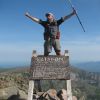
It is wonderful scenery but in my opinion a challenging and considerable undertaking not to be taken lightly.
Attachments
SWC2.jpg
new harbour creek
swc3.jpg
beach
swc4.jpg
swc5.jpg
swc6.jpg
swc7.jpg
swc8.jpg
swc9.jpg
swc10.jpg
kayoz
Nothofagus cunninghamii
 
Posts: 5
Joined: Tue 21 Feb, 2017 3:20 pm
Region: Tasmania
Gender: Male

Re: South West Cape Circuit

Postby mikewb » Sun 05 Mar, 2017 3:42 pm

I completed the loop also exactly 12 months ago and I can relate to some of your observations.

We flew in and completed the walk clockwise in 7 days before walking out along the south coast track which took an additional 5 days.

We also had perfect weather and did not need my raincoat the whole trip! despite of this we still encountered difficulty crossing the SW range. We left Wilsons bight by 7.30am and had a good walk up Mt Karamu. From here we wasted a lot of time looking for a route up and under-estimated the time needed to get up and over to Window -Pane. In the end we ran put of daylight and camped overlooking the bay as we had lost the route and found a few pools which offered barely drinkable water. The next day we found the route and had morning tea at Window-Pane before heading off to Noyhemer.

This is where we really had issues. The route to Faults Bay is easy enough, as soon as we hit the scrub we followed a lead to the coast. This turned out to be Faults Bay itself and we made the regrettable decision to follow the coast around rather then scrub bash back up the hill and look for the inland path. We spent 4-5 hours heading around headlands, rock climbing, intense scrub bashing and re-tracing steps before finally camping on top of a cliff still not at Noyhemer! even though we could see it!

The next morning we continued around having broke the back of the walk the day before and were at camp by morning tea time. This unfortunately meant the planned daywalk to Spain Bay was axed for a mental and physical recovery session at camp!

We found the walk to Horseshoe comparably simple! I was expecting a defined camp site at horseshoe which did not eventuate and we eventually settled for a grass patch by the shore

Tips and Observations:

- New Harbour has poor water availability, carry sufficient from Melaluca for the first night.
- Camp behind the 2nd point at Wilsons Bight, much bigger area and close to water. Worth crossing the rocky beach at low tide however
- Next time I will take the short-cut from Wilsons bight straight to the top of the range as indicated in Chapman's book, much more direct and will save 3 hours of walking around Karamu which we under-estimated.
- Stick inland when approaching Noyhemer and refrain from the temptation of hitting the coast early!
- We were lucky that low tide was mid afternoon during our walk, this meant an easy wade around horseshoe creeks without a swim and it also helped at wilsons bight, plan for this if u can. It also meant at prion beach, we could walk to the end of the beach and wade across the inlet saving us the boat crossing and walk behind the dunes which isnt much fun.
mikewb
Nothofagus cunninghamii
 
Posts: 1
Joined: Sun 05 Mar, 2017 2:36 pm
Region: Western Australia

Re: South West Cape Circuit

Postby kayoz » Tue 07 Mar, 2017 9:09 pm

Yes sounds like we had very similar experiences, we too could see the prize at Noyhemer,but headed inland scrub bashing, crawling hands and knees with pack on to find the "track" again. And yes I think our biggest day was 11 hours and we had a "rest" day at Noyhemer but the Stephens bay "lovely walk for the family" was a bit of a major rest day activity as it turned out, Definitely is a horseshoe inlet camp, last beach to the east, includes a log construction windbreak for what must be a nasty west wind. I left my mobile and solar charger here, it was recovered and returned to me by some really cool wildcare volunteers --thanks girls you rock!,
Definitely add time to published times unless you are gun navigators and take 3 metre steps with each stride
kayoz
Nothofagus cunninghamii
 
Posts: 5
Joined: Tue 21 Feb, 2017 3:20 pm
Region: Tasmania
Gender: Male

Re: South West Cape Circuit

Postby north-north-west » Wed 08 Mar, 2017 7:37 am

How bad is the Horseshoe Creek crossing? I really want to do this loop, but the book descriptions of the creek rather put me off.
"Mit der Dummheit kämpfen Götter selbst vergebens."
User avatar
north-north-west
Lagarostrobos franklinii
 
Posts: 15120
Joined: Thu 14 May, 2009 7:36 pm
Location: The Asylum
ASSOCIATED ORGANISATIONS: Social Misfits Anonymous
Region: Tasmania

Re: South West Cape Circuit

Postby norts » Wed 08 Mar, 2017 3:31 pm

NNW the main creek crossing is not that bad.
This is me crossing the creek in 2012, I also did it in 2017.
It was a bit deeper in '17 just up to my waist, I am short. I did have to head further out into the Inlet this year.
If you try and cross inland it is very deep but only about 15 metres across.
DSCF1568 (Large).jpg


Roger
User avatar
norts
Lagarostrobos franklinii
 
Posts: 2013
Joined: Wed 01 Aug, 2007 10:45 am
Location: Germantown Tas.
Region: Tasmania

Re: South West Cape Circuit

Postby kayoz » Wed 08 Mar, 2017 6:24 pm

Horseshoe creeks were over head high this Feb, lots of rainfall this summer in sw tas, only a short swim, decent quality xtra large garbage bags work well, we actually towed them whilst we waded the 1.5kms to the campsite.(nice to have them off the back) i would count on swimming, as judging creek levels and tides in advance would be a lottery, the scrub is definitely too thick to contemplate that option.
kayoz
Nothofagus cunninghamii
 
Posts: 5
Joined: Tue 21 Feb, 2017 3:20 pm
Region: Tasmania
Gender: Male

Re: South West Cape Circuit

Postby kayoz » Wed 08 Mar, 2017 6:29 pm

Not fast flowing water from the creeks,(we had to swim two creek mouths) it was high tide
kayoz
Nothofagus cunninghamii
 
Posts: 5
Joined: Tue 21 Feb, 2017 3:20 pm
Region: Tasmania
Gender: Male

Re: South West Cape Circuit

Postby north-north-west » Wed 08 Mar, 2017 8:34 pm

Thanks.
Does not sound like fun, but as long as it's close to a campsite I suppose one still has the possibility of drying out a little before squelching on the Melaleuca (or wherever).
"Mit der Dummheit kämpfen Götter selbst vergebens."
User avatar
north-north-west
Lagarostrobos franklinii
 
Posts: 15120
Joined: Thu 14 May, 2009 7:36 pm
Location: The Asylum
ASSOCIATED ORGANISATIONS: Social Misfits Anonymous
Region: Tasmania

Re: South West Cape Circuit

Postby weetbix456 » Thu 09 Mar, 2017 8:45 pm

Very short and sweet. Only one real mandatory swim/wade at the main creek. I picked up some massive liners for packs that they sell at Cradle VC for like $3 or so, and chucked my 75L pack in there easy, lined with another bin bag for extra security. Anti-climax completely - and an all nude swim means clothes stay dry for the other side. I had myself all worked up round the whole circuit and the swim turned out to be a doddle. Very beautiful overall walk.
User avatar
weetbix456
Athrotaxis selaginoides
 
Posts: 1057
Joined: Mon 04 May, 2009 6:01 pm
Location: Launceston
ASSOCIATED ORGANISATIONS: TWGA, TCIA, CragCare
Region: Tasmania
Gender: Male

Re: South West Cape Circuit

Postby relaxtec » Mon 27 Mar, 2017 2:39 pm

Sometimes, it is the unexpected that creates the most memorable walk.
Getting bushwhacked for a while or taking an alternate path that turns out to be not such a good idea.
Gives you something to talk about for years to come!
relaxtec
Nothofagus gunnii
Nothofagus gunnii
 
Posts: 21
Joined: Tue 25 Feb, 2014 3:06 pm
Region: South Australia
Gender: Male


Return to TAS Trip Reports & Track Notes

Who is online

Users browsing this forum: No registered users and 8 guests