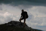
I can't believe it's been five years since I first climbed Mt Picton. I loved it the first time, and thoroughly enjoyed my revisit. Instead of the blue skies and big vistas that the last person in this forum enjoyed, I had a repeat of a total grey-out on the summit, and snow overnight. It's a pretty perfect mountain for a quick overnighter, and that's far more fun than doing it in a single day. Even with no views, evenings up there are wonderful. One day, I'll even get to see further than my feet on top.
Below is a shot of a view I did get, with more, and our route in my blog if you want (natureloverswalks.com)
Mt Picton
Forum rules
Posting large/multiple images in this forum is OK. Please start topic titles with the name of the location or track.
For topics focussed on photos rather than the trip, please consider posting in the 'Gallery' forum instead.
This forum is for posting information about trips you have done, not for requesting information about a track or area.
3 posts
• Page 1 of 1
-
naturelover - Athrotaxis cupressoides

- Posts: 291
- Joined: Mon 23 Apr, 2012 7:07 pm
- Region: Tasmania
- Gender: Female
Re: Mt Picton
![]() by andrewa » Thu 06 Apr, 2017 10:24 pm
by andrewa » Thu 06 Apr, 2017 10:24 pm
I have so many horrible images in my brain from a trip to Federation Peak 30 yrs ago, where we started by climbing Mt Picton, and traversing it to get down into the ?Craycroft R, before climbing Moss Ridge to Federation Peak
It was a "4WD" scramble up with 30kg packs up the side of Picton (as in both arms and legs), and then traversing the top involved leaping from variably snow covered huge boulders to others, with this huge pack on your back, not knowing whether you would overshoot, and fall down between boulders. Followed by a route off the side that was so steep we had to rope the packs down, crossing the E Craycroft river in flood on a slippery log, climbing Moss ridge, with its variety of "mud" cliffs, complete with v small scoporia bushes to hold on to; me being *&%$#! scared about going down the gulley from Bechervaise Pl towards Lake Geeves on slippery snow covered snow grass; then returning to find the Crawcroft 6' higher, and having to fell trees to bridge the river and rope ourselves over, with my tree collapsing mid stream, to eventually get to Farmhouse Ck, and a *&%$#! long walk out.
Really very hard to find any good images from that trip, except the view from Bechervaise plateau when I was sitting there looking over the Arthur Range, wondering whether my mate, who had climbed to the top, was still alive somewhere. The most mentally taxing walk I have ever done.
I have always loved bushwalking, and still do, but this particular trip really did my brain in - I found it incredibly stressful, and consequently unenjoyable, and I was maybe 24 at the time. I would so much more enjoy a blizzard on Bogong than to have to repeat that trip!
But.....nice image of Mt Picton, albeit not "my" image!
A
- andrewa
- Athrotaxis selaginoides

- Posts: 1426
- Joined: Sat 05 Mar, 2011 5:55 pm
- ASSOCIATED ORGANISATIONS: None
- Region: Victoria
- Gender: Male
Re: Mt Picton
![]() by naturelover » Thu 06 Apr, 2017 10:32 pm
by naturelover » Thu 06 Apr, 2017 10:32 pm
Wow Andrew. That sounds a total epic!!!! What an amazing trip. Funny how we always remember and talk about the ones like that and the easy ones get forgotten.
-
naturelover - Athrotaxis cupressoides
- Posts: 291
- Joined: Mon 23 Apr, 2012 7:07 pm
- Region: Tasmania
- Gender: Female
3 posts
• Page 1 of 1
Return to TAS Trip Reports & Track Notes
Who is online
Users browsing this forum: No registered users and 14 guests