The westerly winds were still howling around the South West Cape and the weather was gloomy when we woke up. I was up early in preparation for a big day but was having trouble rousing Peter from his slumber. With about 7-8 Chapman hours (or about 11 mere mortal hours ) on the books to Window Pane Bay and a bit of un-tracked terrain to be negotiated I figured an early start was on the cards. Bruce was up and packing at first light but Peter seemed a bit suprised that we had chosen such an early hour to be moving. By the time we had breakfast and were finally packed and walking I figured we were already a good hour off the pace. We crossed the last little bay on the south coast that was lined with smooth granite and quartz rocks and large piles of driftwood and then began our ascent of the range. As soon as we left the coast it was a very ‘in your face’ sort of track. Getting any sort of a hand hold to pull yourself upwards to the next available thing to grab onto was the only way to progress on the slippery track. I was happy we had chosen to do the circuit in a clockwise direction as I could imagine this being a very taxing descent in reverse. Especially being at the end of a long day. The coastal bush soon gave way to open ground but the heart thumping climb continued. With the steepest pinch up to a small knoll behind us the grade began to ease a bit. The weather had thankfully been easing as well and the views back to the east and northwards were breathtaking. Such a wild vista. We still had to press on higher towards Mt Karamu before the Cape itself came into view. As so often is the way in Tassie the transition from one region to the next was instant and dramatic. From our rest spot high on the range we could pick out the thick forest and smooth sandy beaches to the east, each with it’s own sentinel of rocky headlands. But on the west side of the range the landscape dropped away rapidly to a rugged series of high cliffs and wild looking coves.The contrast was stark. As wild as the south coast is, the west coast down near the cape is on a level all of it’s own. The moderate swell that had been thumping the sands of the south coast beaches had doubled in size to the west and the south coast that had offered some limited form of shelter to mariners had given way to a wild unrelenting coast line that had been mercilessly battered by huge swells and furious storms for centuries and offered no protection for boats at all. The wind scoured top of the South Coast Range was devoid of any vegitation above knee high and the small knolls and scattering of rocky outcrops would provide scant protection for anybody unlucky enough to be up there in bad weather. From Mt Karamu there was no sort of pad at all and as a result we ended up taking 3 individual routes heading upwards before picking up a pad to the highest point on the range. I took one last look over my shoulder to the south and the east before we began dropping down the spine of the range towards Window Pane Bay.
We spent the afternoon descending towards this target and a late lunch break on a high rocky outcrop gave us stunning views to Mutton bird Island, East Pyramid and a collection of other small islands off the coast of Noyhener Beach. Our high perch gave us a birds eye view of where we suspected the pad down to the coast might go. It all looked so close. And finally after a long haul ........we got lost ! Without warning the reasonably well defined pad we had been following just stopped. With varying opinions on which way we should go, what followed was a 10 minute interlude where we were all in danger of disappearing up each others clacker due to our aimless wandering in circles. After crossing a small swampy plateau we eventually picked up a pad heading north again. We continued to descend from the open tops of the range down into thick forest before finding our way to the top of a large blowout on the coast at the southern end of Window Pane Bay. 11 hours after leaving Wilsons Bight we had finally arrived. Over a rewarding desert of apple pie and custard we recalled John Chapman’s suggestion that the ground we had just covered should be do-able in 7 to 8 hours. Before we climbed wearily into our sleeping bags we came to the conclusion that Mr Chapman must surely be a 7 foot 6 giant capable of covering 10 feet in a single stride. He obviously must have a GPS for a brain and two stroke brushcutters for forearms. None of us relished the thought of ever going on a walk with Mr Chappy ! Our campsite at Window Pane Bay was quite spacious and very scenic with Window Pane Creek and views all the way down the west coast to the Cape forming the backdrop as the sun sank behind the islands to the west.
With a much shorter day ( 3 – 4 Chappy hours ) forecast from Window Pane to Noyhener Beach we had a lazy breakfast and a much slower start to the day. After arriving late the day before and only having had a cursory look around that morning I felt as though we were leaving Window Pane Bay much to soon as we hoisted our packs and headed off in the direction of Noyhener Beach. The track ascended gently upwards through light forest and after spending most of the previous day out in the open it was enjoyable to be under a canopy of trees again. It wasn’t to last long though as we came back out into the open overlooking Island Bay. While we had been in amongst the trees the clouds had taken on a far more sinister aspect and we were soon reaching for our pack covers and wet weather gear. In the grand scheme of things what followed would have just been an average day on the West Coast but the rain was heavy enough to give us a good drenching and the wind straight out of the west was strong enough to make walking difficult at times. The next couple of hours was a bit of a chore and I was eternally great full that we weren’t still up on top of the range. We were making good time simply because it wasn’t worth stopping as we began crossing a series of heavily forested creek lines. The rain slowly began to ease but the conditions underfoot were particularly slimy and the short sharp descents down to the creek lines were a bit tricky to stay upright on. Ascending steeply from one small creek bed we picked up a route marked with fairly new looking pink tape. It wasn’t long though before we realized that following the tape trail was simply leading us around in circles. It seemed as though some one had been throwing up tapes as they went along in order to be able to find their way back again if they happened to be heading in the wrong direction. Whatever the reason, following the tapes was a useless exercise. We soon adopted what would become our standard practise for the rest of the trip when we became directionally challenged. Peter would wander off in various different directions seeking the path of least resistance. Bruce would methodically start scanning his GPS loaded with waypoints accurate to the nearest 10 km’s and I would pull out my trusty map and compass all the time muttering helpful words like maybe, possibly and whaddaya reckon......!! After our remarkably good start to the day we ended up wasting a lot of time before ultimately agreeing on the wrong course of action and ending up high on the coast overlooking Faults Bay.
Faults Bay, now there’s an apt name for where we had come to be ! Our 3 – 4 Chappy hours was set to become another epic day as we back tracked inland and did battle with some particularly stubborn scrub to maintain a basic N.E. compass bearing while searching for an easier route. As we eventually veered back towards the coast and Noyhener Beach came into view. The information we had from he of the GPS brain and the 10 foot stride indicated that at this point it would be possible to just drop down off the cliff onto the coast line and follow the foreshore around to the beach. Yeah right ! The jolly green giant obviously has the aquatic ability of a fur seal to add to his skills set!! After twice dropping down the rocks only to find our way blocked we scrambled back up into the bush and did our best wombat impersonations to continue progressing. We finally burst forth from the bush onto the wide expanses of Noyhener Beach and waded a shallow creek. And up a set of chain link steps we found our new home set well back from the beach. A study of the walker registration book located here showed that only a small number of parties passed by this way each year. When you subtract the entries made by people walking into Spain Bay and returning the same way then the numbers of people on the SW Cape Circuit becomes suprisingly thin. On February 19th we were only the 3rd group to have passed this way coming from the south for the summer !!.
Just before the sun dipped below a dark band of clouds out to sea a fishing boat dropped anchor inside Mutton Bird Island. Despite the protection of the island it rose and fell sharply on the relentless swells and I was happy to be sleeping where I was and not out there. Light Rain chased us into our tents early. Sometime later that night I shot bolt upright in my tent, startled from a deep sleep by the loudest most menacingly tormented thunder clap I have ever heard!!. It sounded as though the earth was being ripped open and we were all about fall into the abyss. It would have been loud enough to awaken the ghosts of every shipwreck on the Cape! Suprisingly very little came of it and we woke the next morning to an overcast but dry morning.
A rest day had always been in the plans for Noyhener beach so after breakfast we went for a walk sans back packs to Stephens Bay. “ Follow the beach around to the end of Chatfield Point and rock hop around this with one short climb over some headlands to Stephens Bay “ said the wise sage of bushwalking. Maybe once a decade when the Blue Moon is in Aquarius, the world is 3 degrees off it’s axis and the 7.5 knot winds are coming from the Northeast and Southwest at the same time, then the tide maybe low enough to rock hop around Chatfield Point. To rock hop around what we were looking at happened to be the stuff of pure fantasy !! We back-tracked from the end of the point to the first available spot where it was possible to scramble up onto the top of the headland. From there we burrowed our way north in a manner that would have impressed even the most hardcore wombats and echidna’s. After expending way to much energy on our ‘rest day ‘ we finally located the southern end of Stephens Bay. The middens amongst the dunes were amazing and worth every effort we had made to get there. While I stood in front of these middens trying hard to comprehend just how an ancient race of people had survived in such a harsh place it occurred to me that these people had lived in harmony here with the environment for for thousands of years and the only trace of their existence is a few piles of shells while in just over 200 years we had managed to completely destroy large tracts of the land and leave plastic crap spread along every stretch of even the most remote coastline. And we are still arrogant enough to think that we are the smart ones. After poking around the dunes for a while we chose to ignore Chappies advice and ventured inland on our return to Noyhener Beach. A relatively small amount of route finding was required and we wandered back through an opening in the dunes to Noyhener in far easier fashion than we had going the other way. It had been a very enjoyable day but as we sat eating our diner we began to contemplate the two ranges we had to cross and creeks we had to swim before we were on the final stretch back to Melaleauca.
We were off early the next morning and we seemed to be following a clear path marked with an array of flotsam and jetsam through the dunes and up onto the foothills of the SW Cape Range. And then just to stick with a theme .......we got lost. Lost is probably the wrong word to use. We knew where we were. It just didn’t happen to be anywhere near where we should have been! I thought the pad we had been following had been very well defined but somehow we had ventured way too far north of where we should be ascending. The elevation of our position made it easy to compare the contours of our map with the lay of the land and our position in relation to Hannant Inlet but it didn’t make it any easier to trudge along the undulating ridge south to where we should have been. If we hadn’t of had the good fortune of having clear weather to help find the way then the challenges of our day would have been about 10 fold ! After a steep desecent of the SW Cape Range we had little time to relax before it was upwards and onwards over the Pascoe Range. The thin white vien of a track snaking up the flanks of the range disappeared about 3 quarters of the way up and then it was a matter of choosing your own course. It had been a constant source of amazement on this walk how many times it seemed we were following a well used pad heading in the general direction of where we wanted to go when it would just simply stop. No fading away or becoming harder to follow but just simply stop, like a complete dead end. After taking the ‘direct ascent’ route to the top of the range we arrived at a cairn with stupendious views down to Horseshoe Inlet, Mt Rugby and the numerous peaks and ridges of the Erskine Range. A steep descent down off the Pascoe Range lead us to an undulating track over the lower plains towards Horseshoe Inlet. As we had been descending the range the light drizzle that had been falling had cleared away to a beautiful calm afternoon and we took an extended afternoon tea break on the final rise overlooking the calm waters of the inlet. We were definitely beginning to sense the end of this adventure was near. We eventually got moving again and had almost reached the foreshore of Horseshoe Inlet when...............the track just stopped again! This hardly ever occurred at the start of the day but was a phenomenon reserved for when you felt like you were almost there !! Fortunately the scrub bash through to the shoreline was easy enough to negotiate and we soon discovered that wading along the banks of the inlet was a far easier method of travelling than trying to stay dry walking around the banks. We soon came to a very deep but narrow looking creek line barring our way. From the photos I had seen of Horseshoe inlet Creek I was pretty sure that this wasn’t it. Whatever it was it had to be crossed so it was out with the garbage bags to cover our packs and in we went ! Bruce was the guinea pig and I was amazed at just how buoyant his pack was inside the garbage bag as I had expected it to sink a bit and require some effort to keep it afloat. I was in next and the bank dropped away sharply beneath my feet. The calm dark water was as chilly as you would expect a creek in the south west to be but thankfully the afternoon sun was strong and warmed us quickly . Peter was the last in and made quite a fashion statement in his hat, budgie smugglers and gaiters. If he’d been anywhere else on the planet he probably would have been arrested for getting around like that!! Horseshoe inlet wasn’t too much further on and soon us wombats were doing our best platypus impersonations again. The crossing of Horseshoe inlet was a bit of an anti- climax and wasn’t much more than a waist deep wade across about a 10 to 15 metre wide channel. Towing our packs that floated happily along behind us we continued around the shoreline heading northward. After a good look around a small sandy beach adorned with plastic crap hanging from the trees we came to the conclusion that the campsite must be a bit further than expected and sure enough another 10 minutes of wading brought us to a small headland before finding a well protected campsite just around the corner. Bruce emerged from the water with a nasty looking cut to his leg after discovering a submerged rock shelf just before he waded from the water for the final time. Everything was so perfectly still and peaceful as we set up camp for our final night .
The next morning everything was completely fogged in but perfectly calm. Two swans resembled a pair of Loch Ness monsters as they glided out of the fog searching the bottom of the inlet for breakfast. As we sat munching on our own breakfast the fog ever so slowly began to lift revealing mirror perfect reflections on the surface of the inlet. As the top of the Pascoe Range began to poke it’s head through the fog our high point of yesterday looked impossibly far away. With all the hardest yards behind us it was a very casual approach to the morning and was somewhere around 11 am before we hit the track heading southwards again to Melaleuca. Maps can be so deceiving at times and I think we all might have had it in our heads that our final few hours would be along a fairly level well benched track back to Melaleuca Inlet. Normally towards the end of a good multi day walk I tend to be moving a bit slowly trying to extend the time I get to spend in the bush but on the final section of the Port Davey track back to the airstrip I couldn’t wait to be done with it. If this bogfest is an indication of the state of the rest of the PD track then I hope I never have to do it. To have this slush bucket of a swamp marked as a TRACK on a map is almost a disregard of the safety of bushwalkers! I’m not allergic or afraid of mud at all but we spent our final hours of what had been a completely amazing walk attempting to avoid the hazards and traps of what was nothing more than a wade in a swamp. I can’t imaging how dismal it would have been wading through this quagmire in foul weather. Not a moment to soon we left the bottomless swamp of the PD track behind us and arrived back at our starting point. Two Wildcare volunteers we chatted with at the airstrip confirmed what the Noyhener Beach log book had told us two days ago. Not many people had ventured west of Wilsons Bight in the last few months. A quick scan of the melaleuca log book showed pages and pages of people heading east to Cockle Creek over the past eight days that we had been away. After a bonus landing at Bruny Island to drop some passengers of we arrived back at the Cambridge airport in much the same conditions as we had left. Cold, rain and wind. A cold beer, a big steak and a warm bed awaited !!
And the memories of an awesome walk will live forever !
S.W.Cape Trip Report ( part 2 ).
Forum rules
Posting large/multiple images in this forum is OK. Please start topic titles with the name of the location or track.
For topics focussed on photos rather than the trip, please consider posting in the 'Gallery' forum instead.
This forum is for posting information about trips you have done, not for requesting information about a track or area.
14 posts
• Page 1 of 1
S.W.Cape Trip Report ( part 2 ).
![]() by Mechanic-AL » Thu 27 Apr, 2017 7:30 pm
by Mechanic-AL » Thu 27 Apr, 2017 7:30 pm
- Attachments
-
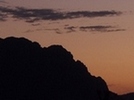
- The Cape.
-
- North to Window Pane Bay.
-
- Window Pane Bay back down to the Cape.
-
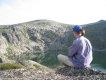
- Stephens Bay Midden.
-
- Horseshoe Inlet Glass.
-
- Foggy start to the last day.
-
- So still and peaceful.
"What went ye out into the wilderness to see?
A reed shaken in the wind"?
A reed shaken in the wind"?
- Mechanic-AL
- Athrotaxis cupressoides

- Posts: 419
- Joined: Tue 24 Sep, 2013 7:38 pm
- Region: Western Australia
- Gender: Male
Re: S.W.Cape Trip Report ( part 2 ).
![]() by taswegian » Thu 27 Apr, 2017 9:30 pm
by taswegian » Thu 27 Apr, 2017 9:30 pm
That's an enthralling experience by way of your entertaining description of our great outdoors.
Those images certainly highlight some of Tasmania's finest.
Your sentiments on the very short time we've taken to mess this place up is something many find hard to swallow.
Thanks for sharing.
Those images certainly highlight some of Tasmania's finest.
Your sentiments on the very short time we've taken to mess this place up is something many find hard to swallow.
Thanks for sharing.
-
taswegian - Phyllocladus aspleniifolius

- Posts: 888
- Joined: Tue 27 Jul, 2010 8:34 pm
- Region: Tasmania
- Gender: Male
Re: S.W.Cape Trip Report ( part 2 ).
![]() by Lizzy » Fri 28 Apr, 2017 6:55 am
by Lizzy » Fri 28 Apr, 2017 6:55 am
Sounds like an adventure to reminisce about! Well done & thanks for the report 
-
Lizzy - Athrotaxis selaginoides

- Posts: 1074
- Joined: Mon 16 Nov, 2009 1:13 pm
- Region: New South Wales
- Gender: Female
Re: S.W.Cape Trip Report ( part 2 ).
![]() by bigkev » Fri 28 Apr, 2017 6:01 pm
by bigkev » Fri 28 Apr, 2017 6:01 pm
Loved the report and the photos. I have a fat bustard factor (a bit like dog years) that I multiply by when using Mr Chapman's times. You make a very salient point about us thinking that we are the 'smart ones'.
Thanks for sharing
Thanks for sharing
-
bigkev - Athrotaxis cupressoides
- Posts: 442
- Joined: Sat 30 Jun, 2012 6:44 pm
- Region: Victoria
- Gender: Male
Re: S.W.Cape Trip Report ( part 2 ).
![]() by Mechanic-AL » Fri 28 Apr, 2017 7:36 pm
by Mechanic-AL » Fri 28 Apr, 2017 7:36 pm
Thanks for the comments
. It really is an amazing part of the state and I feel privileged to have had the opportunity to have a bit of a poke around down there.
Like any young kid growing up in the 70's I spent a ridiculously short amount of time studying the history of Tasmania's Indigenous inhabitants. I was always a bit skeptical that anybody could really live in the southwest for any extended period of time. And that is why the Stephens Bay middens where of such significance to me. When I was standing in front of them it was no longer typed lines in an outdated history book. It was undeniably real and probably the closest connection I will ever make with the original inhabitants. I'm dead sure there are a lot of people who will find my sentiments "hard to swallow". Maybe they should be taken to Stephens Bay and shown the sum total of a thousand years of indigenous garbage !
"What went ye out into the wilderness to see?
A reed shaken in the wind"?
A reed shaken in the wind"?
- Mechanic-AL
- Athrotaxis cupressoides
- Posts: 419
- Joined: Tue 24 Sep, 2013 7:38 pm
- Region: Western Australia
- Gender: Male
Re: S.W.Cape Trip Report ( part 2 ).
![]() by hobes » Sat 29 Apr, 2017 8:42 am
by hobes » Sat 29 Apr, 2017 8:42 am
Great report and photos. We completed the circuit in January this year. A memorable walk! It was hard to believe the amount of plastic garbage we found on the beaches. The majority looks like it comes from fishing boats. We also had fun with navigation challenges particularly in thick fog around Mt. Karamu. Thanks for bringing it back to life again with your excellent report.
- hobes
- Atherosperma moschatum

- Posts: 62
- Joined: Mon 26 Aug, 2013 10:21 pm
- Region: Tasmania
- Gender: Male
Re: S.W.Cape Trip Report ( part 2 ).
![]() by ofuros » Sat 29 Apr, 2017 9:09 am
by ofuros » Sat 29 Apr, 2017 9:09 am
Great looking adventure, Mechanic-Al...thanks for taking us there.
Mountain views are good for my soul...& getting to them is good for my waistline !
https://ofuros.exposure.co/
https://ofuros.exposure.co/
-
ofuros - Athrotaxis selaginoides
- Posts: 1930
- Joined: Fri 05 Feb, 2010 4:42 pm
- Region: Queensland
- Gender: Male
Re: S.W.Cape Trip Report ( part 2 ).
![]() by north-north-west » Sat 29 Apr, 2017 11:26 am
by north-north-west » Sat 29 Apr, 2017 11:26 am
Marvellous report. Must get around to this next summer.
As for the Old Port Davey track, in foul weather it's not that muddy, just *&%$#! wet. You spend most of your time ankle to knee deep in water. And the creek crossings -
As for the Old Port Davey track, in foul weather it's not that muddy, just *&%$#! wet. You spend most of your time ankle to knee deep in water. And the creek crossings -
"Mit der Dummheit kämpfen Götter selbst vergebens."
-

north-north-west - Lagarostrobos franklinii

- Posts: 15114
- Joined: Thu 14 May, 2009 7:36 pm
- Location: The Asylum
- ASSOCIATED ORGANISATIONS: Social Misfits Anonymous
- Region: Tasmania
Re: S.W.Cape Trip Report ( part 2 ).
![]() by Mechanic-AL » Sat 29 Apr, 2017 12:39 pm
by Mechanic-AL » Sat 29 Apr, 2017 12:39 pm
Just wondering how you got on leaving Noyhener Beach Hobes ?
We went back down to the beach from the campsite and then made our way through the opening in the dunes to the right (north ). We followed a trail of plastic that appeared to have been strung up in the bush to indicate the route only to end up way north looking down on Hannants Inlet. We ended up quite a long way off where the track up the range actually was.
And my advice to you N.N.W. Don't bother. You'll hate it ! Not an Abel in sight, nothing of significance to be climbed, no alpine vegitation........And besides that, I just love knowing I have been somewhere where you haven't yet !!
"What went ye out into the wilderness to see?
A reed shaken in the wind"?
A reed shaken in the wind"?
- Mechanic-AL
- Athrotaxis cupressoides
- Posts: 419
- Joined: Tue 24 Sep, 2013 7:38 pm
- Region: Western Australia
- Gender: Male
Re: S.W.Cape Trip Report ( part 2 ).
![]() by north-north-west » Sat 29 Apr, 2017 1:25 pm
by north-north-west » Sat 29 Apr, 2017 1:25 pm
Mechanic-AL wrote:And my advice to you N.N.W. Don't bother. You'll hate it ! Not an Abel in sight, nothing of significance to be climbed, no alpine vegitation........And besides that, I just love knowing I have been somewhere where you haven't yet !!
I've almost run out of Abels anyway. Have to find something to fill the gap.
"Mit der Dummheit kämpfen Götter selbst vergebens."
-
north-north-west - Lagarostrobos franklinii
- Posts: 15114
- Joined: Thu 14 May, 2009 7:36 pm
- Location: The Asylum
- ASSOCIATED ORGANISATIONS: Social Misfits Anonymous
- Region: Tasmania
Re: S.W.Cape Trip Report ( part 2 ).
![]() by hobes » Sun 30 Apr, 2017 7:44 am
by hobes » Sun 30 Apr, 2017 7:44 am
Just wondering how you got on leaving Noyhener Beach Hobes ?
We went back down to the beach from the campsite and then made our way through the opening in the dunes to the right (north ). We followed a trail of plastic that appeared to have been strung up in the bush to indicate the route only to end up way north looking down on Hannants Inlet. We ended up quite a long way off where the track up the range actually was.
As I recall, we headed up past the creek and crossed the sand dune area to a buoy which marked the start of a short section of scrubby forest. We followed plastic markers and ended up in the foothills on a ‘pad to nowhere’. We needed to head in a more easterly direction in order to pick up the track.
- hobes
- Atherosperma moschatum
- Posts: 62
- Joined: Mon 26 Aug, 2013 10:21 pm
- Region: Tasmania
- Gender: Male
Re: S.W.Cape Trip Report ( part 2 ).
![]() by Suz » Sun 30 Apr, 2017 5:17 pm
by Suz » Sun 30 Apr, 2017 5:17 pm
Thoroughly enjoyable read.
Please go ahead and do the full Port Davey track so that I can read about your hilarious misadventures. I will give $5 to your trip fund Haha
Please go ahead and do the full Port Davey track so that I can read about your hilarious misadventures. I will give $5 to your trip fund Haha
- Suz
- Athrotaxis cupressoides
- Posts: 440
- Joined: Fri 03 Apr, 2015 7:58 am
- Region: Western Australia
- Gender: Female
Re: S.W.Cape Trip Report ( part 2 ).
![]() by Mechanic-AL » Sun 30 Apr, 2017 6:50 pm
by Mechanic-AL » Sun 30 Apr, 2017 6:50 pm
5 bucks buys a lot of tinea cream and foot powder..........I could be tempted Suz !
That sounds like the same naughty bouy that sent us up the garden path too Hobes. I wouldn't mind doing that walk again and cutting down all the crap thats hanging in the trees.
AL
That sounds like the same naughty bouy that sent us up the garden path too Hobes. I wouldn't mind doing that walk again and cutting down all the crap thats hanging in the trees.
AL
"What went ye out into the wilderness to see?
A reed shaken in the wind"?
A reed shaken in the wind"?
- Mechanic-AL
- Athrotaxis cupressoides
- Posts: 419
- Joined: Tue 24 Sep, 2013 7:38 pm
- Region: Western Australia
- Gender: Male
Re: S.W.Cape Trip Report ( part 2 ).
![]() by kayoz » Mon 01 May, 2017 4:28 pm
by kayoz » Mon 01 May, 2017 4:28 pm
Nice one MechanicAL, they say everyone has at least one book in them! I did like the brushcutter arms descriptor for the infamous chappius navigatious celratii, as you say awesome memories.....
- kayoz
- Nothofagus cunninghamii

- Posts: 5
- Joined: Tue 21 Feb, 2017 3:20 pm
- Region: Tasmania
- Gender: Male
14 posts
• Page 1 of 1
Return to TAS Trip Reports & Track Notes
Who is online
Users browsing this forum: No registered users and 2 guests