After our wedding in January 2010, leave bidding began with our employer shortly thereafter for three weeks leave in January 2011. It would allow us to see the tennis with my parents, duck down to Tasmania for Frenchman's and then return to Adelaide along the Great Ocean Road for our first wedding anniversary.
My dad, a very fit 59 year old didn't need much convincing to come along, so while we refined our gear (including the addition of an MSR Mutha Hubba tent) looking to save grams, he started buying from scratch as I jealously looked on. Hours of reading through Bushwalk Tasmania and several other websites followed late at night as I prepared us for a walk which was “considerably more arduous” than the Overland, while we trained during the day climbing with packs from Waterfall Gully to the summit of Mount Lofty.
The journey just to get to the Frenchman's Cap carpark seemed full of obstacles. Firstly, my wife would be 8 weeks pregnant, so my extended family and I were cautious at first. The doctor's didn't seem to think it was a bad idea, and I was aware that not letting her come would probably have ended in a divorce! My Dad and I took as much weight as we were able, but both being fairly lean ourselves it still meant my wife carried quite a heavy pack. A stroke of luck meant our drive to Melbourne from Adelaide was completed during the 8 hour window where the highway was actually open after massive flooding in Victoria. The last dilemma, a diverted flight into Tasmania due to poor weather meant a bus ride to get our intended destination. Hire cars, insurance, EPIRBs, hotel rooms, park passes and flights really can be quite a hard process to organise – I sure do hope Tasmanians appreciate how lucky they are to have this on their doorstep.
Eventually, on the 21st of January we rolled in to Queenstown mid afternoon. We had a quick look around and took some photos from the lookout as the morning's rain and low cloud slowly cleared. We then returned to the hotel for final gear preparations and packing.
22/01/2010
The 22nd dawns cold but reasonably clear. Light stratus and valley fog is obvious as I peer out the hotel room with excitement - surely it will rise and burn off. We eat as much breakfast as possible with butterfly stomachs, and jump into the car for the drive. The cloud quickly lifts and disappears as we drive for what seems an age. The obligatory photo at the Frenchman's lookout on the Lyell Highway precedes our arrival at the spacious carpark. Horror stories of cars on bricks with missing wheels and smashed windows are left in the hands of the expensive hire car insurance. Only a few cars are there – will this mean the track is quiet, or had people bussed in?
A guy called Cody walks over and introduces himself in the carpark, soon heading off while we fluff around with pack straps and boot laces. After a couple of group photos we are soon walking up to the registration booth. Twelve months preparation and organising has finally been rewarded as I lead out with my wife and Dad following closely behind.
Registration at the logbook shows it will probably be reasonably quiet on the track, not surprising given the weather over the last few weeks and the summer which has never really arrived. With heavy packs, the going is slow and the track very up and down. We lose time at the wash-down station removing boots so that convertible pants can be changed to shorts – I really don't get why they don't have a zip down the side of the leg (or made much wider) so that they can be removed without taking off the boots. Gaiters come on and after eating some morning tea, almost an hour has disappeared.
The track up around Mt Mullen is not too arduous, although I see two tiger snakes slither away just centimetres in front of my boot, one being quite a monster (at least 5 or maybe 6 feet) – I'm most definitely not a snake person. I begin to feel pain in my shoulders which I haven't felt since the Overland Track two years earlier, but my legs and cardio are barely ticking over – the training up Mount Lofty is paying off. We catch a glimpse of the Cap on descent down towards the Loddon Plains, with the new waterproof camera getting a real workout – albeit in the dry!
We stop for lunch at the Loddon bridge. I fear for my Dad's bee allergy as large, bee like things buzz around us aggressively as soon as the food appears. I would later realise they were just big march flies. We decide to finish eating as we walk to solve the bug problems and continue on our way across the Loddons. The new track work (thanks, Dick Smith) makes the first section from the bridge a delight, although not terribly scenic walking. A lot of the trackwork involves raised/compacted path with a large gutter down one side – it is very easy to walk, but not a terribly long term solution in my opinion. The raised gravel has already collapsed in several places down into the water channel, and will surely deteriorate fairly quickly.
The well made duckboard and the raised gravel track soon fans out into a maze of muddy footprints criss-crossing the buttongrass plains. While I am conscious of trying to do as Parks say and avoid spreading the track, we still spend ages trying to avoid the worst of the mud bogs. Dick Smith was absolutely right when he said the track is a disgrace. I understand people don't want to arrive at Vera with head to toe mud, but also understand that avoiding the mud spreads the track. The problems is that the geographical route the track follows is just ridiculous. As you trudge or dance the Loddons, you are never more than about a kilometre from a ridgeline to the north where the track should be. It wouldn't need to be up high on the ridge – just up high enough so it's above the floodplain would solve the problem.
I begin to tire, and my 2.5 litres of fluid is getting low. We turn right and start up the last part of the Loddons where it is more of a very, very thin creek bed cut deeply into top soil. We are overtaken by three young, fit looking guys but later catch up with them and borrow their shady rest spot as they push on. We are glad to have them around because I've started to become a little bit nervous that we'd simply been following a few muddy footprints here and there - no track of any sort. I've been thinking for the last half an hour perhaps we should be crosschecking our progress with the compass, but suddenly that's unimportant. At least if we're lost, they are too.
We reach the mudslide up Philp's Lead and it becomes obvious why it is marked on the map – the track could have easily been lost at this point. We follow the pink tape tied to trees and head off to the right of the mudslide and into the forest. I am now out of drinking water at the bottom of a long climb, after walking four hours in strong sun and 30+ degrees heat. I fill up at the creek by the bridge and put in an aquatab just to be sure. The walk from here is nice, cool rainforest and my resolve picks up after the debilitating Loddons. We reach the top of the ridge and begin walking across towards Lake Vera. I now have a throbbing dehydration headache, and my wife sounds like she's getting one too. Dad is quietly and slowly bringing up the rear.
Knowing the worst is over, I expect the hut to appear any second. It doesn't. Another hour or so of trudging (although on a nice dry, formed track) finally leads to the chimney of the composting toilet and we stagger past there for another 100m into the Lake Vera hut around 7pm – just a bit under 10 hours of walking. We take our boots off to find my wife is the only one with leeches - two fairly full ones who are quite happy to fall off on their own. We accidentally leave the hut door open and let some flies in, surely annoying the other hut residents in our dehydrated state of exhaustion. A litre of water and two panadol later, my headache continues so I start cooking while the others set up bedding in a half full hut. It is very, very hot in there.
Back Country dehydrated meals work well again, although we will in the future probably get a dehydrator and make our own food. Two more groups of two arrive in the hut after us. We fall into bed on the top bunk just after 9pm.
23/12/10
I sleep poorly. While physically exhausted, mentally my brain will not switch off and I question the decision to do this walk – day one has certainly been a massive battle, much harder than expected. Two out of three of us have massive headaches including my pregnant wife, and my Dad certainly doesn't seem to have enjoyed anything about it. I had spent ages recounting to him and others our wonderful experiences on the Overland Track and how much we had loved it, now feeling guilty that I'd promised something that wasn't going to be delivered. The temperature of the hut does not help. After stories of blizzards and snow in January and February, I had not expected to be unable to sleep due to warmth.
All three of us stir by about 730am, but licking our wounds, getting breakfast ready and gear packed, means we aren't on our way until after 9am. On his return from the bathroom, my Dad is surprised by a hut full of people giving a very ordinary rendition of “Happy Birthday”, although it gets very quiet at the part where his name is announced. I failed to mention that somewhat important detail to our obliging hut friends. What an amazingly different way to spend your 60th birthday. The birthday card we present to him will be a few less grams to carry in my wife's pack, and a few more for him A solitary Italian walker who is on his way out today sits with his head in his hands for at least an hour. He says he is simply trying to prepare mentally for the the walk out across the Loddons. He encourages us that it is easier from here on and that somewhat buoys our spirits. While it is to be a shorter day distance wise, I know the majority of it will be steep climbs or descents and am keen to get going – we are the last party out of the hut.
The walk from Vera hut is in complete contrast to day one and it's another cracker, weather wise. The scenery as we walk around Lake Vera is simply stunning rainforest, reminding me of the walk from Narcissus to Cynthia Bay along the shores of Lake St. Clair. By the time we reach the start of the massive climb up to Barron Pass, we are all feeling a bit less depressed – it's amazing how some beautiful scenery makes you forget about the weight on your back and the pain in your legs. We stop to snack on apples next to a small waterfall and I suddenly feel like I'm back in Tasmania – it is cool, wet and just sublimely peaceful in every way. I think about my mobile phone in it's dry sack at the top of my pack and close my eyes, imagining it falling into the waterfall and allowing me to completely forget life at work . The sinking feeling I get when my phone rings when I'm on call will not be ruining my day today.
We battle up to Barron Pass. Every time I think we are just about there, I get a glimpse of the Needles and realise we are nowhere near. It is hard work – throwing my pole up a few metres, then grabbing tree roots and standing on little rock protrusions to pull and push my way up each tricky section. I then pick up my pole, grab the pole of the person behind me, and help pull them up too. The only thing I can imagine being more difficult than what I'm doing, is my wife doing it all with the nausea and fatigue of first trimester pregnancy.
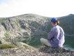
Eventually we reach the final staircase to Barron Pass and arrive in brilliant sunshine with hardly a cloud in the sky. We can see the Cap in all her glory, the lakes at her base and many peaks in the area – it truly is an awe inspiring view and achievement to be sitting in the Tasmanian wilderness. Suddenly the planning and the day one slog is starting to pay dividends. I hope my Dad & wife think the same, but I don't seem to think they are as amazed as I. We contemplate lunch, but decide to push on.
Shortly after, one member of the party decides they are suddenly hungry and have to eat NOW. Two minute noodles take more like twenty minutes when you are parked on the side of a mountain trying to cook for three. They are quite delicious, but I've decided hot food for lunch is not exactly the best idea – it was quite easy to manage on the Overland, but here in Frenchman's stopping on a thin, rough track and unpacking all the gear to heat up water really is frustrating. Next time I think lunch will be cold food.
We scoff down as much as we can and after a quick repack, we're on our way. We run into a couple of groups walking out who tell us it is easier walking from here. It is. Not easy, but easier. Across the rockfall boulder field and then up and down over and over again as we join onto the ridge line. The walking along this section is stunningly beautiful. Once again the hard physical work is blocked out by the rewarding views. It isn't until days later I read in a logbook that the rockfall/boulder field just after Baron Pass is the turnoff towards Davern's Cavern. I'd love to go there sometime.
We work our way along the ridge and then up a huge staircase to another pass near the turnoff to Pine Knob. The trackwork is simply fantastic – such a contradiction with the Loddons. We descend very steeply and literally stumble into the hut at Tahune. I'd read stories of people being surprised by the hut, and now understand why – it certainly just seems to be right there in front of you when you least expect it. It's now after 4pm, it's taken us seven and half hours to do day two.
We have some decisions to make. The weather is meant to be closing in early morning with low cloud and rain. We have allowed for 5 days to give flexibility of a summit attempt - at the end of day 2, during day 3 or early morning day 4 - before heading out. My Dad and wife seem hard to convince, but eventually with a bit of food and water into them they agree. We waste 5 minutes finding the right track (the tracks to the toilet/helipad/camping spots are not marked at all) but soon are on our way. My new Ultrasil Sea To Summit daypack gets its first workout, and I'm quite impressed. The only problem is the shoulder strap adjustment doesn't hold and just goes straight out to maximum extension – I end up adjusting the length and tying the two loose ends from each shoulder together in a knot.
The summit track is steep. Before the saddle, it turns left and wanders up onto the quartzite, and then back around towards the saddle, climbing slowly. The final section involves one particularly tricky section which makes me a little nervous – approximately a 6 foot climb up a smooth rock slab with only a thin ledge at the bottom. A fall in other places on the walk might cause a broken leg or arm – a fall here could potentially break a spine or neck. We scramble up and continue on our way as I start getting nervous that our pace could see us climbing down in darkness. I have one headtorch in the daypack as a precaution, but I would find out later that the batteries are pretty much flat as it has been accidentally switched on in my luggage for days.
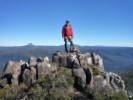
After about an hour, my wife is really really struggling – understandably so. I am torn between the summit and making sure she is okay. I don't want to leave her on the side of the mountain as the wind has picked up considerably and it is getting quite cold. We stop every few minutes and eventually she falls in a heap and can't go on. I give her my big bag of lollies insisting she eat every one (which normally would not be a problem), and we sit down and discuss what to do. Eventually I decide to quickly go up (expecting the summit to be just around the corner) and then come back down and tell her how close it is. I head around the next corner in a jog with my Dad and the summit appears further away than ever. It's amazing how it can visually seem close, and then later when you round another corner, it seems to be even further away. After not more than about 10 minutes I see the flat rocky track I recognise from several youtube videos and race up to the rocky cairn. I tell my Dad to take some photos while I race down and get her. I meet her about 5 mins down, striding up, now re-energised with lollies - although a little indignant that we left her. After I quickly explain I was just checking if it was close and coming straight back to get her, I'm off the hook and we walk hand in hand to the summit cairn about one and half hours after leaving Tahune. We have made it!
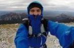
It's cold and windy with overcast cloud about 1000' above the summit, but no rain yet. It's definitely not dark and the views are spectacular, but the sun setting behind the clouds means it seems night time is not far away. With only shorts and t-shirts on, we literally take as many photos as we can in 4-5 mins without freezing and start heading down. I was adamant that if we made the summit I would soak up the view for ages and crawl over to the edge to peer over the biggest cliff in Australia. Cold, tired and with darkness approaching, that really doesn't seem very important. It must be the quickest summit visit in history.
We make much better time on the way down, but the one tricky spot proves to be much more difficult to go down than up. It reaffirms the fact that I would never survive the Western Arthurs or Federation Peak. I manage to find a handhold and somehow get my foot on the thin ledge below. My wife seems to manage better than me (probably because she has four hands and four feet at the moment) while I'm standing underneath helping her. My Dad, the last down is also having a hard time. Eventually I offer my shoulder for him to stand on and it's the easiest way down out of all three methods.
About a half hour before darkness we rock in to find the hut reasonably full. We swap stories with others including Cody, who spent four hours on the summit reading a book, having a sleep and playing hacky sack with the group of three who overtook us on day one. I feel relaxed now we've made it, although annoyed that I couldn't enjoy the summit through worry about my party and the approaching weather and the darkness. It's not until after dinner that I'm in bed and I realise that the Cap doesn't give herself up easily. I'm sure there are many people who done all these hard yards and slept right here in this bunk who've never made the summit due to poor weather, or had views like we did. I quickly realise I've got nothing to be annoyed about - we've been lucky to summit one of Tasmania's remotest mountains during one of the most ordinary summers. She has smiled on us, albeit briefly.
24/2/2010
I wake at midnight to the sound of rain. It gets louder and louder, and while I think about what it's going to do to the track on the way out, I'm glad for the relief it seems to be bringing to the hut temperature – almost instantly the hot, stuffy air seems to be cooling down and I actually have to get into my silk liner. The rain becomes an absolute torrent several times during the night, waking me. I slither down to the toilet at about 5am to find the track a muddy, flowing river.
We wake in the morning to light drizzle and intermittent rain. My dad and I were thinking of a day trip down to Irenabyss today, but the 1000m descent and climb over a poorly marked track wouldn't interest us in the dry, let alone the wet. We decide on a rest day at Tahune and spend the majority of the day inside the hut reading, playing cards and snoozing.
Tahune strikes me as a terribly magical and mythical place. It seems like it a scene from from Avatar or Lord of the Rings. The hut is surrounded by dense forest at the bottom of a ridge line, where the lake feeds down into a stream. It's hard to really see much of anything because the trees block your view. The only place to get any real view of the lake is from the campsites looking across the lake to the summit, or on the summit climb looking back down. It's an amphitheatre of amazing rock and rain forest surrounding a deep, clear and cool lake. It doesn't look that big, but then would probably take a whole day to bush bash around because of the foliage density. It's quiet, wild and remote, yet strangely feels like home. There's no mobile phone on the table, and no tv on the wall. It's nature at it's best and I feel like I've won a a get out of jail free card from modern, hectic society.
I read comments in the logbook and am quite disgusted to find many people being crude and posting inappropriate pictures or even destroying other people's words and pictures. How pathetically immature and neanderthal people can be. I wonder if they realise the logbooks will become part of the state's history archives, perhaps to be perused by school kids or historians in a few hundred years.
There are a few interesting articles left in the hut which I systematically read. The most interesting is an account of the track cutting – suddenly only two days to Frenchman's seems like a light stroll. Another interesting article describes two walkers who became snowbound in Tahune hut for 8 days before a break in the weather allowed a helicopter rescue.
The rain stops after lunch but the Cap and most peaks are covered by fast moving low cloud. We walk out to the helipad and take a few photos, and then some across the lake. It has risen dramatically overnight, probably by at least a metre. There are waterfalls cascading down from the cap towards the Lake, but by late afternoon these have dropped back to a trickle. It is now bitterly cold and anything more than a few minutes outside results in chilled hands – the elevation is now quite apparent.
Most groups head off around 2pm once the rain has stopped. We imagine the track to be more like a river in places and are certainly glad to have had the luxury of a rest day. The last two walkers (quite an odd couple) leave after 4pm and do not appear fit or well prepared. We hope they arrive back to Vera before dark in the poor conditions.
Late that afternoon quite a few parties arrive into Tahune. One group is two Queensland Park Rangers on holiday. I recognise one as a ranger who had been working on the Overland Track on a secondment in 2009, although he did seem quite keen to keep this under wraps. We have moved from the top bunk (after finally realising it was so much hotter up higher) to the bottom bunk furthest from the hut door. We are glad to have relocated as some walkers who arrive and unpack by the hut door smell like they've been walking for about a month without a shower. Some of those who arrive decide to head up to the summit but find it clouded in and slippery. Thankfully those who are in desperate need of shower decide on a swim in Tahune and after managing not to drown in the frigid water, come out smelling a lot better than when they went in.
Lake Tahune hut is better than I expected. I had read online about black mould covering the walls because of lack of ventilation and natural light, but it certainly was livable. My Dad swept it out while everyone was summitting. The mouldy walls have obviously been washed down by someone and are looking good. It is definitely looking run down, but reading an article in the hut about it's construction makes it quite obvious that building a hut to handle these environmental conditions in such a remote place is no easy feat. The hut stood under 2.5m of snow during the blizzard described earlier and kept two men alive, so it is obviously well built. The track work is, in my opinion, much more of an immediate priority.
Hearing the conditions some endured walking in today once again makes me appreciate how lucky we'd been to summit. We sleep well that night on the cooler, lower bunks in a very full hut.
25/1/2011
We awake and follow breakfast by packing. The tracks around the hut are still quite wet, but definitely not rivers like the day before. We head off around 0830, now anxious to retrace our steps quickly and safely. Aches and pains seem to have improved slightly with the rest day, but pulling the pack on still brings a grimace or two.
The track is wet. One section of boardwalk is completely submerged, but the rain holds off. An hour or so in, the cloud has lifted and we can see Barron Pass. We move on fairly well, lighter packs helping our speed. The views still amaze me between Tahune & the Barron. You have to stop walking to enjoy the view, as every step must be placed carefully. Damp, mossy tree roots prove the most slippery, with rocks generally being safest. The mud across the ridge and towards the boulder field is still fairly minimal, and proves my point about the Loddons being a ridiculous choice for route. We reach the pass in good time, and only pause for a few photos and a quick snack.
Just down from the Barron we run into a man and lady. He carries an old style pack with two 5 foot planks of wood sticking out and seems quite cheery. He asks which Tahune bunk we slept on, and then mumbles something about how that's the one he always sleeps on. After passing him by, I make a snide remark to the others that he must have been asking about the bunk to boast about how many times he has walked the track. We have a giggle about it and remember a walker on the Overland who always had done everything better, faster and more times than anyone else.
The trip down from the Barron to Vera is much more treacherous. The going is slippery and my Dad loses his footing several times on slippery tree roots. We help each other down, step by step, thankful for the excellent trackwork in places. We see a wallaby just near the large rock about halfway down to the lake shore. It seems to have amazingly thick fur – almost like steel wool – and would obviously need it in the cooler months. It seems unfussed and continues picking through the bush. A short time later we come across two old black and lime green gaiters, and decide to pick them up and carry them with us. We're not sure if they have been thrown away deliberately to avoid being carried or if they've been lost, but either way we want to keep this stunning environment clean.
We avoid the hassle of cooking a hot lunch enroute, rather raiding our snacks and pushing through to the hut by about 2pm. We have walked out more than two hours quicker than we walked in. There we eat lunch and then collapse from sore knees and ankles. My Dad has quite a sore on the top of his foot and one toe looking a bit worse for wear, while the wife has sore collarbones – a couple of smelly socks wrapped around her pack straps seem to help. I've been lucky so far.
Vera hut is empty and very, very clean. Someone has obviously spent a lot of time here cleaning up – there's not a spec of dust on the floor and it looks like quite a palace compared to Tahune. After lunch, I set out to read the hut logbook.
The latest post is by a girl walking in with a man called Terry Reid. Alongside her post Terry has written that he has replaced a broken window pane at the hut and cleaned it up as best he can. There are new rolls of toilet paper and a big bottle of antiseptic hand gel for everyone to use. It is then that I realise that Terry (an absolute legend of everything Frenchman's) was the man we saw earlier. His comment about sleeping in his favourite bunk suddenly makes sense, and I feel guilty about passing him off as a bragger. If you are reading this Terry, I'm very sorry.
Later that night, the two Queenslanders arrive in to Vera and tell us more about Terry. He was the senior ranger at Queenstown Parks Office for something like 30 years. He has walked the track to the Cap more times than anyone else – it was his absolute passion. After Terry's retirement, Parks decided to no longer do any real track or hut maintenance on the Frenchman's track and it was left to be forgotten about. Terry then volunteered in his retirement to walk the track and do what he could to keep it in good condition, and walks it many times a year. The planks of wood in his pack must have been for running repairs to Tahune. What amazing passion for the area he must have. He has scribbled a small diagram with rough directions to Davern's Cavern, but I'm sure I will not remember it. I listen in awe to the two Queenslanders about this man, and promise myself that if I ever walk the track again I will be sure to contact Terry and offer to help him with maintenance if he will walk in with me and share his knowledge.
There is a note in the hut from someone who has lost their gaiters on the track with contact details in Hobart. We leave them with two girls who are heading that way after the walk, as we will be driving north.
We again snag a lower bunk and get quite a decent sleep.
26/1/2011
I now know why the Italian sat here for an hour with head in hands, contemplating the long walk out and the Loddons. I too feel like a helicopter ride to the car. The others seem aware of the task ahead and mumble away quietly over breakfast and packing.
We make quite an early start, on the track by about 0700 in light, intermittent drizzle. The mud becomes quite apparent immediately, with bogs both much larger and deeper than during the walk in. The knees are really feeling it now, every step down hill seems to twang my knee ligaments and tendons like a guitar string. We head down Philp's Lead and are glad for the cool conditions in the forest. While it's probably about 14-15 degrees, with gaiters, waterproof pants and a waterproof jacket, we are really quite hot. Sunnies are impossible to use, fogging up instantly, as does the camera lens, making photos a misty blur.
We hit the large mudslide and the thin deep creek which winds down to the Loddon's. It's here we really need to decide on how to tackle this. I'm adamant we should just plough through the ankle to knee depth water because it's the last day and who cares if our gear gets wet. I have trouble convincing the others, particularly Dad who still tries to hop around but eventually we all settle into trudging down the creek bed with squelching boots. It is quite refreshing and cooling to step in the water.
Lower down, we hit the mud. It is mid calf deep and I just plough right through. I get frustrated waiting for the others to catch up as I'm making great time, but I guess I should be more understanding. I make a joke that my pregnant wife now has four legs and should be walking twice as fast, but when I turn around to see how much trouble I'm in she's on her backside in the mud and hasn't heard. Dad catches her a few minutes later to stop a faceplant in deep mud, and she's very grateful. We stop for lunch at a small creek and a couple of groups of two or three go quietly by on their way in.
After lunch we get 100m before stopping again. My wife's ankle is sore and she is hobbling very badly. I insist we stop to check the damage – it's a big, busted blister on the bone of her left ankle and I don't know how she has managed up until now. My Dad and I cut a round hole in a few bandages and place them over. With her boot back on, it's 100% again and we're on our way. Who would have thought a university elective like sports injuries would have come in handy...
We are convinced the Loddons and mud are finished about three times before we actually reach the suspension bridge over the river. Covered in mud to the knee, we press on, passing a few more groups. Further along we pass a group of nine, some of whom haven't even reached the Loddons by 2pm – we hope they are quick walkers. The slog up Mullens, while steep, doesn't compare to Mount Lofty so we make good progress with lighter packs. My wife has to keep her heart rate to 150 or less according to doctors orders, so we stop a couple of times for it to settle down.
Thankfully no more snakes are encountered on the duckboard. The track is really poor in many places, much worse than the way in. Not only is it probably the result of the rain, but probably also the fact that the track has been so busy today with us passing at least 20-25 people. A bit of traffic really does make a lot of difference. Vera hut is certainly going to be full tonight. The wash down station is not required going out, saving plenty of time.
We sigh with major relief at the sight of the Franklin after hearing it for about half an hour. There's a couple having a swim and it looks very refreshing. I quickly finish off the registration, while picturing a hire car Hyundai Getz on bricks with no windows. Thankfully we find it, untouched and retrieve some garbage bags – into which go muddy and stinky boots, gaiters, socks and waterproof overpants. It's only been 7.5 hours on the way out, almost 3 hours quicker.
As we drive onto the highway towards Tullah, our overnight stop, I'm certainly glad to be out. I've definitely had my fix of walking and can return to civilisation.
When the Parks website and Chapman said Frenchman's is “considerably more arduous than the Overland Track” they weren't joking. It really was quite a challenging walk for us. While I'm glad we did it and the scenery between Vera and the summit was just spectacular every single step of the way, I really think the Overland is called Australia's premier bushwalk for a reason. You get just as much reward without having to give nearly so much.
We spend a day at Cradle showing my Dad around and fly back to Melbourne. We give up on the Great Ocean Road as we have to be back in Adelaide for another ultrasound.