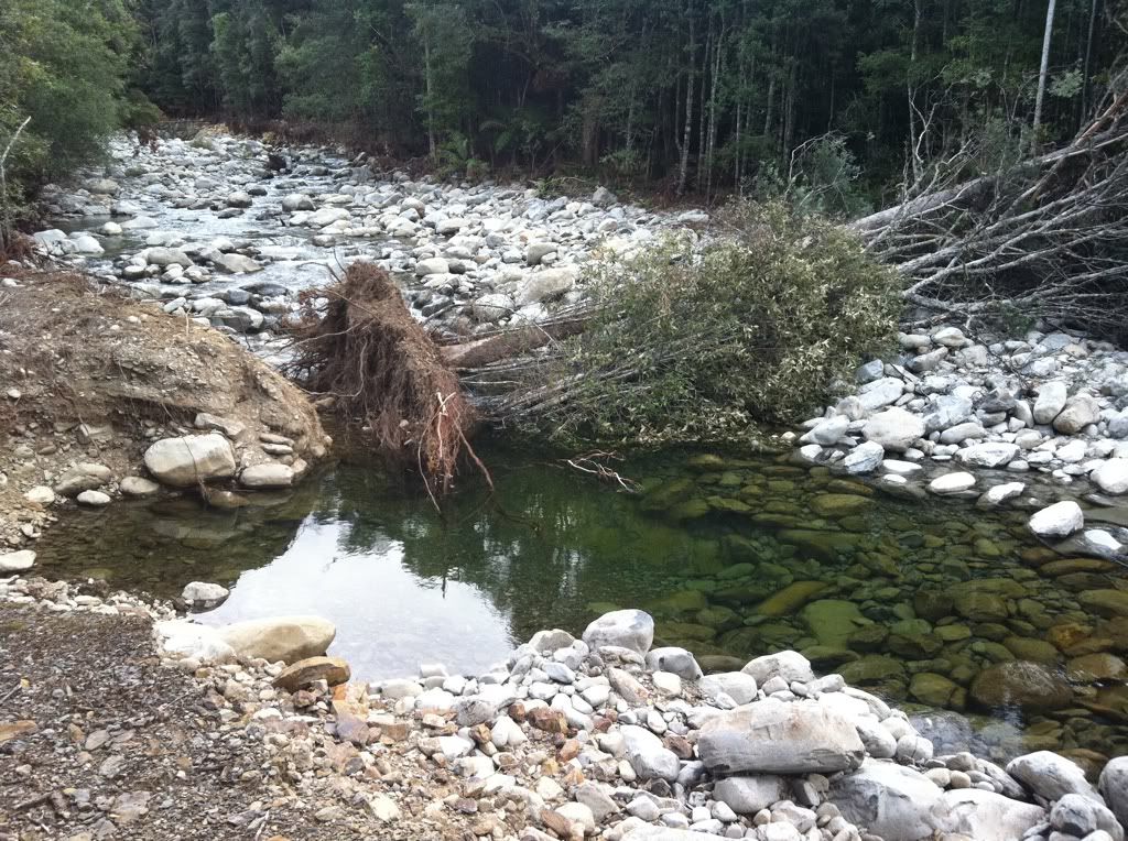
We went on a fact-finding drive up to Meander Falls car park today.
A few kms up meander falls rd the bridge is now completely gone with boulders blocking the road.
Smoko Road road ends with a huge sinkhole preventing vehicles from continuing any further. Two cars were packed here suggesting walkers had continued on foot, the road is not very wide here requiring a 4 point turn in the x-trail to head back down.
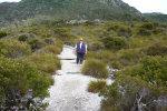
A temporary alternative route to the Meander Falls Track car park has been opened but this is a four-wheel drive only track and is likely to be closed in wet weather. The signs for this road are hand written on pieces of white cardboard, not very weather hardy. The first part of this road was very good then it turned right onto a freshly graded track. This track was muddy after the last few days rain but the going was fine in the x-trail. Ground clearance would be an issue for a normal car with the track being packed down with deep muddy furrows. This section was only a few kms long then the road improved to a well-graded dirt road meeting back up with meander falls rd and an easy drive to the car park.
Forgot to take a camera so the photo of the temporary road was taken with our phone camera but it should give you an idea of the road.
Meander Falls Road Access
Forum rules
Posting large/multiple images in this forum is OK. Please start topic titles with the name of the location or track.
For topics focussed on photos rather than the trip, please consider posting in the 'Gallery' forum instead.
This forum is for posting information about trips you have done, not for requesting information about a track or area.
52 posts
• Page 1 of 2 • 1, 2
Meander Falls Road Access
![]() by chow » Sun 27 Mar, 2011 7:47 pm
by chow » Sun 27 Mar, 2011 7:47 pm
- Attachments
-
- Temporary Alternative Road Access to Meander Falls
Recent walks, Lobster Falls, Rinadeena Falls, Bakers Beach and the Nob, Shadow Lake Circuit , Montezuma Falls, Holwell
-
chow - Nothofagus gunnii

- Posts: 10
- Joined: Wed 09 Feb, 2011 1:53 pm
- Location: Deloraine
- Region: Tasmania
- Gender: Female
Re: Meander Falls Road Access
![]() by ILUVSWTAS » Sun 27 Mar, 2011 7:52 pm
by ILUVSWTAS » Sun 27 Mar, 2011 7:52 pm
chow wrote:Two cars were packed here suggesting walkers had continued on foot,
Indeed we did!! That was me and Ollster. The walk to the old carpark takes about 30-35 minutes.
Nothing to see here.
-

ILUVSWTAS - Lagarostrobos franklinii

- Posts: 11046
- Joined: Sun 28 Dec, 2008 9:53 am
- Region: Tasmania
- Gender: Male
Re: Meander Falls Road Access
![]() by chow » Sun 27 Mar, 2011 7:59 pm
by chow » Sun 27 Mar, 2011 7:59 pm
Sorry we didn't meet up, how was the walk once you got to the carpark, we are thinking about doing a walk up there in a few weeks with some visitors from Victoria???
Recent walks, Lobster Falls, Rinadeena Falls, Bakers Beach and the Nob, Shadow Lake Circuit , Montezuma Falls, Holwell
-
chow - Nothofagus gunnii
- Posts: 10
- Joined: Wed 09 Feb, 2011 1:53 pm
- Location: Deloraine
- Region: Tasmania
- Gender: Female
Re: Meander Falls Road Access
![]() by ILUVSWTAS » Sun 27 Mar, 2011 8:01 pm
by ILUVSWTAS » Sun 27 Mar, 2011 8:01 pm
It was a beautiful walk. Without doubt the nicest creek you will see anywhere along with one of the prettiest forests i've been in.
Took around 5 hrs return to Mother Cummings at a casual pace.
That hole in the road is sure impressive!! We did wonder about the roadblock on the falls road....
Took around 5 hrs return to Mother Cummings at a casual pace.
That hole in the road is sure impressive!! We did wonder about the roadblock on the falls road....
Nothing to see here.
-
ILUVSWTAS - Lagarostrobos franklinii
- Posts: 11046
- Joined: Sun 28 Dec, 2008 9:53 am
- Region: Tasmania
- Gender: Male
Re: Meander Falls Road Access
![]() by north-north-west » Sun 27 Mar, 2011 8:34 pm
by north-north-west » Sun 27 Mar, 2011 8:34 pm
ILUVSWTAS wrote:chow wrote:Two cars were packed here suggesting walkers had continued on foot,
Indeed we did!! That was me and Ollster. The walk to the old carpark takes about 30-35 minutes.
Ahhh, so you got up Mother Cummings. How was the weather?
"Mit der Dummheit kämpfen Götter selbst vergebens."
-

north-north-west - Lagarostrobos franklinii
- Posts: 15120
- Joined: Thu 14 May, 2009 7:36 pm
- Location: The Asylum
- ASSOCIATED ORGANISATIONS: Social Misfits Anonymous
- Region: Tasmania
Re: Meander Falls Road Access
![]() by ILUVSWTAS » Sun 27 Mar, 2011 8:44 pm
by ILUVSWTAS » Sun 27 Mar, 2011 8:44 pm
Beautiful!!
What a beautiful walk through a lovely forest following an amazing creek!!
What a beautiful walk through a lovely forest following an amazing creek!!
Nothing to see here.
-
ILUVSWTAS - Lagarostrobos franklinii
- Posts: 11046
- Joined: Sun 28 Dec, 2008 9:53 am
- Region: Tasmania
- Gender: Male
Re: Meander Falls Road Access
![]() by stepbystep » Sun 27 Mar, 2011 9:20 pm
by stepbystep » Sun 27 Mar, 2011 9:20 pm
ILUVSWTAS wrote:Beautiful!!
What a beautiful walk through a lovely forest following an amazing creek!!
How did Oll rate it as opposed to the Dell track?
The idea of wilderness needs no defense, it only needs defenders ~ Edward Abbey
-

stepbystep - Lagarostrobos franklinii
- Posts: 7707
- Joined: Tue 19 May, 2009 10:19 am
- Location: Street urchin
- Region: Tasmania
- Gender: Male
Re: Meander Falls Road Access
![]() by north-north-west » Sun 27 Mar, 2011 9:43 pm
by north-north-west » Sun 27 Mar, 2011 9:43 pm
It's not bad up top either, although I could have done without the Cape Pillar standard wind, and the snow being blown across from Ironstone et al
Yes, a beautiful forest/creek walk. Better than the Meander Falls track, I think.
Yes, a beautiful forest/creek walk. Better than the Meander Falls track, I think.
"Mit der Dummheit kämpfen Götter selbst vergebens."
-
north-north-west - Lagarostrobos franklinii
- Posts: 15120
- Joined: Thu 14 May, 2009 7:36 pm
- Location: The Asylum
- ASSOCIATED ORGANISATIONS: Social Misfits Anonymous
- Region: Tasmania
Re: Meander Falls Road Access
![]() by walkinTas » Sun 27 Mar, 2011 10:46 pm
by walkinTas » Sun 27 Mar, 2011 10:46 pm
No maybe about it! Smoko creek walk is way prettier than the Meander Falls walk. Sadly I am yet to see Smoko Falls in all its glory.
- walkinTas
- Lagarostrobos franklinii
- Posts: 2934
- Joined: Thu 07 Jun, 2007 1:51 pm
- Region: Tasmania
Re: Meander Falls Road Access
![]() by ollster » Mon 28 Mar, 2011 6:41 am
by ollster » Mon 28 Mar, 2011 6:41 am
stepbystep wrote:
How did Oll rate it as opposed to the Dell track?
More pleasant walking, open forest and a better track, although I did enjoy the log crossing and deep thundering falls/chute on the Dell track.
"I refuse to join any club that would have me as a member."
-

ollster - Lagarostrobos franklinii
- Posts: 3983
- Joined: Tue 02 Sep, 2008 4:14 pm
- ASSOCIATED ORGANISATIONS: LoveMyGoat.com
- Region: Australia
Re: Meander Falls Road Access
![]() by north-north-west » Mon 28 Mar, 2011 1:13 pm
by north-north-west » Mon 28 Mar, 2011 1:13 pm
Hang on, Luvverboy - you went up there with Ollie? Do you mean HE was the "P-plater in a Corolla" whose ability to handle the road concerned you?
Oh dear. I am just soooo disillusioned.
Oh dear. I am just soooo disillusioned.
"Mit der Dummheit kämpfen Götter selbst vergebens."
-
north-north-west - Lagarostrobos franklinii
- Posts: 15120
- Joined: Thu 14 May, 2009 7:36 pm
- Location: The Asylum
- ASSOCIATED ORGANISATIONS: Social Misfits Anonymous
- Region: Tasmania
Re: Meander Falls Road Access
![]() by Crum » Tue 29 Mar, 2011 10:46 am
by Crum » Tue 29 Mar, 2011 10:46 am
Does this track cross both Smoko Creek and the Meander River and go all the way up to the carpark at the very end of the road? I'm keen to do the walk again soon and just wanted to comfirm this
-

Crum - Atherosperma moschatum

- Posts: 83
- Joined: Tue 22 Apr, 2008 10:20 pm
- Location: Blow Head
- Region: Tasmania
- Gender: Male
Re: Meander Falls Road Access
![]() by north-north-west » Tue 29 Mar, 2011 11:01 am
by north-north-west » Tue 29 Mar, 2011 11:01 am
The vehicle access gets you to the carpark, but by a rather circuitous route. And it does have some rough patches.
I have no idea what the walking track itself is like. I would think it's a lot rougher than it used to be, although it will probably have been remarked since the floods.
I have no idea what the walking track itself is like. I would think it's a lot rougher than it used to be, although it will probably have been remarked since the floods.
"Mit der Dummheit kämpfen Götter selbst vergebens."
-
north-north-west - Lagarostrobos franklinii
- Posts: 15120
- Joined: Thu 14 May, 2009 7:36 pm
- Location: The Asylum
- ASSOCIATED ORGANISATIONS: Social Misfits Anonymous
- Region: Tasmania
Re: Meander Falls Road Access
![]() by chow » Tue 29 Mar, 2011 11:10 am
by chow » Tue 29 Mar, 2011 11:10 am
Hi Crum
The temporary mud track cuts through scrub and comes out on the road up the car park to meander falls, bypassing the damaged bridge and sinkholes. We parked right at the car park and did a quick walk down the meander river and across the suspension bridge. We were not equipped to walk any further that day so can't tell you about the walking track
Smoko creek Rd is totally impassable by car a short way up the rd and I am told that it takes about 30 -35 mins to walk to the the carpark there.
Recent walks, Lobster Falls, Rinadeena Falls, Bakers Beach and the Nob, Shadow Lake Circuit , Montezuma Falls, Holwell
-
chow - Nothofagus gunnii
- Posts: 10
- Joined: Wed 09 Feb, 2011 1:53 pm
- Location: Deloraine
- Region: Tasmania
- Gender: Female
Re: Meander Falls Road Access
![]() by Nick S » Mon 04 Apr, 2011 7:08 pm
by Nick S » Mon 04 Apr, 2011 7:08 pm
I walked up Mother Cummings just last Saturday. 4.5 hrs return to the car - with a moderate pace on the way up.
You can only get a few hundred metres along Smoko road now, have to walk about 15min to reach the old carpark, and another 15 before you reach the turnoff.
It's real nice forest and quite easy walking along the overgrown road so we didn't mind at all.
You can only get a few hundred metres along Smoko road now, have to walk about 15min to reach the old carpark, and another 15 before you reach the turnoff.
It's real nice forest and quite easy walking along the overgrown road so we didn't mind at all.
-
Nick S - Phyllocladus aspleniifolius

- Posts: 624
- Joined: Thu 20 Mar, 2008 4:55 pm
- Location: Launceston
- Region: Tasmania
- Gender: Male
Re: Meander Falls Road Access
![]() by Crum » Tue 05 Apr, 2011 7:12 pm
by Crum » Tue 05 Apr, 2011 7:12 pm
Went for a drive on Friday. Not a real lot left of the Meander River bridge. The water level looked to have been a fair amount higher than the actual road too
-
Crum - Atherosperma moschatum
- Posts: 83
- Joined: Tue 22 Apr, 2008 10:20 pm
- Location: Blow Head
- Region: Tasmania
- Gender: Male
Re: Meander Falls Road Access
![]() by ILUVSWTAS » Sat 09 Apr, 2011 7:17 pm
by ILUVSWTAS » Sat 09 Apr, 2011 7:17 pm
...
Just an update, went up the Dell track today, there's a sign up saying temporary access to the falls down a side road. Seems they are still accessible.
Just an update, went up the Dell track today, there's a sign up saying temporary access to the falls down a side road. Seems they are still accessible.
Last edited by ILUVSWTAS on Fri 02 Sep, 2011 8:55 pm, edited 2 times in total.
Reason: rule 1
Reason: rule 1
Nothing to see here.
-
ILUVSWTAS - Lagarostrobos franklinii
- Posts: 11046
- Joined: Sun 28 Dec, 2008 9:53 am
- Region: Tasmania
- Gender: Male
Re: Meander Falls Road Access
![]() by Guy yaffa » Thu 07 Jul, 2011 9:33 pm
by Guy yaffa » Thu 07 Jul, 2011 9:33 pm
Hi everyone
Just wondering if anyone is walking the meander falls track this weekend (sat 9 July). I,m by myself and wish to join someone for the walk. I do have a 4 wheel vehicle for the dodgy road.
I'm fit so happy to tag along with anyone who s keen.
Thanks
Guy
Just wondering if anyone is walking the meander falls track this weekend (sat 9 July). I,m by myself and wish to join someone for the walk. I do have a 4 wheel vehicle for the dodgy road.
I'm fit so happy to tag along with anyone who s keen.
Thanks
Guy
- Guy yaffa
- Nothofagus cunninghamii

- Posts: 2
- Joined: Thu 07 Jul, 2011 9:16 pm
- Region: Tasmania
- Gender: Male
Re: Meander Falls Road Access
![]() by x71101 » Fri 22 Jul, 2011 8:59 am
by x71101 » Fri 22 Jul, 2011 8:59 am
Just went for a rec drive. two bridges are completly gone. Only access to the carpark at the start of the meander falls and split rock walks is via the 4wd track previously mentioned. Definately only for high clearance 4wd. We had no problems in 4wd but this track will go under in heavy rain. The smoko road is also completly blocked (road collapsed at small creek crossing) about 2km past the meander falls road intersection. With the current Forestry Tas budget problems will any of these roads ever be fixed? Looks like we have longer walks in the future!
Following is from Forestry web site, the reference to March/April is interesting! Which decade?
Start quote"Meander Falls Road and Smoko Road
Recent heavy rains and flooding have washed away two bridges on the Meander Falls Road. The lost bridges are over the Mother Cummings Rivulet and the other over the Meander River. This was the only road access to the Meander Falls Track, Split Rock Track, Dickson's Track, Stone Hut Track, Croft Track, Bastion Cascade Track and the Meander Picnic Area. A temporary alternative route to the Meander Falls Track car park has been opened but this is a four wheel drive only track and is likely to be closed in wet weather
This road is an important access for bushwalkers to the Meander Forest Reserve World Heritage Area. Forestry Tasmania are looking at options to reopen two wheel drive access to these areas.
Additionally the first bridge on the Smoko Road is damaged and unpassable, this is the normal access to the Mother Cummings Creek / Summit track. This bridge is likely to be replaced in late March / early April. " end quote.
Regards, David
- x71101
- Nothofagus cunninghamii
- Posts: 1
- Joined: Thu 05 Feb, 2009 10:26 am
- Region: Tasmania
Re: Meander Falls Road Access
![]() by dplanet » Sat 04 Feb, 2012 7:53 pm
by dplanet » Sat 04 Feb, 2012 7:53 pm
Enjoyed Meander Falls & Split Rock and Smoko Falls & Mother Cummings Peak walks last month. Tent was pitched near Meander Falls and Smoko Road junction to do the two day walks.
Full days are expected because of extra kms to walk into the start of the track to Smoko Falls & Mother Cummings Pk (see previous messages).
And so is the same for Meander Falls & Split Rock; but you could save additional 7kms (both ways go/return) in a 4WD. There is a temporary route for 4WD to get into the carpark where the tracks start.
- Attachments
-
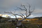
- Not sure if this is the peak because the plateau is rather level. But, if you have a gps and want to explore around the plateau, do take this large cairn as a waypoint that will help leading you back to the main track for the return trip.
- Mother-Cummings-Pk.jpg (203.41 KiB) Viewed 32128 times
-
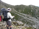
- One km of rock slope climbing. The climbing track is marked with cairns. Keep an eye out for the next cairn. If difficulty to see cairns (experienced 3 times), keep up climbing north and cairns will be found. Take your time and its worth the climb.
- Split Rock Slope.jpg (189.14 KiB) Viewed 32128 times
-
dplanet - Phyllocladus aspleniifolius
- Posts: 580
- Joined: Thu 04 Oct, 2007 8:21 pm
- Location: Ormond-Caulfield, Melbourne
- Region: Victoria
- Gender: Female
Re: Meander Falls Road Access
![]() by prickle » Sat 04 Feb, 2012 8:08 pm
by prickle » Sat 04 Feb, 2012 8:08 pm
Thanks for the update "dplanet"
Looking to do a day walk up Dixon's next weekend .. was wondering what access was going to be like
Stuart
Looking to do a day walk up Dixon's next weekend .. was wondering what access was going to be like
Stuart
- prickle
- Nothofagus gunnii
- Posts: 44
- Joined: Sun 11 Mar, 2007 7:01 pm
- Location: Hobart
Re: Meander Falls Road Access
![]() by north-north-west » Mon 13 Feb, 2012 8:07 pm
by north-north-west » Mon 13 Feb, 2012 8:07 pm
dplanet:
That's nowhere near the summit, you're still below the scrubline there. The high point is marked by a much larger cairn, it's (does mental navigation stuff) southish along the summit plateau, about 500m or so, right on the western edge.
That's nowhere near the summit, you're still below the scrubline there. The high point is marked by a much larger cairn, it's (does mental navigation stuff) southish along the summit plateau, about 500m or so, right on the western edge.
"Mit der Dummheit kämpfen Götter selbst vergebens."
-
north-north-west - Lagarostrobos franklinii
- Posts: 15120
- Joined: Thu 14 May, 2009 7:36 pm
- Location: The Asylum
- ASSOCIATED ORGANISATIONS: Social Misfits Anonymous
- Region: Tasmania
Re: Meander Falls Road Access
![]() by dplanet » Tue 14 Feb, 2012 10:30 pm
by dplanet » Tue 14 Feb, 2012 10:30 pm
20m height is the difference. It's a relaxing walk from the cairn to it. No time for exploring the plateau due to safety issue on the return. It's a rather rough descent.
-
dplanet - Phyllocladus aspleniifolius
- Posts: 580
- Joined: Thu 04 Oct, 2007 8:21 pm
- Location: Ormond-Caulfield, Melbourne
- Region: Victoria
- Gender: Female
Re: Meander Falls Road Access
![]() by tasadam » Wed 15 Feb, 2012 7:04 am
by tasadam » Wed 15 Feb, 2012 7:04 am
I was talking with Forestry a few weeks ago, they told me that work would be starting on the Smoko Road (Mother Cummings access) repair February.
-
tasadam - Magnus administratio

- Posts: 5940
- Joined: Tue 10 Apr, 2007 6:58 pm
- Location: Near Devonport, Tasmania
- ASSOCIATED ORGANISATIONS: TasmaniART, Smitten Merino, Macpac
- Region: Tasmania
- Gender: Male
Re: Meander Falls Road Access
![]() by chow » Sat 18 Feb, 2012 8:34 pm
by chow » Sat 18 Feb, 2012 8:34 pm
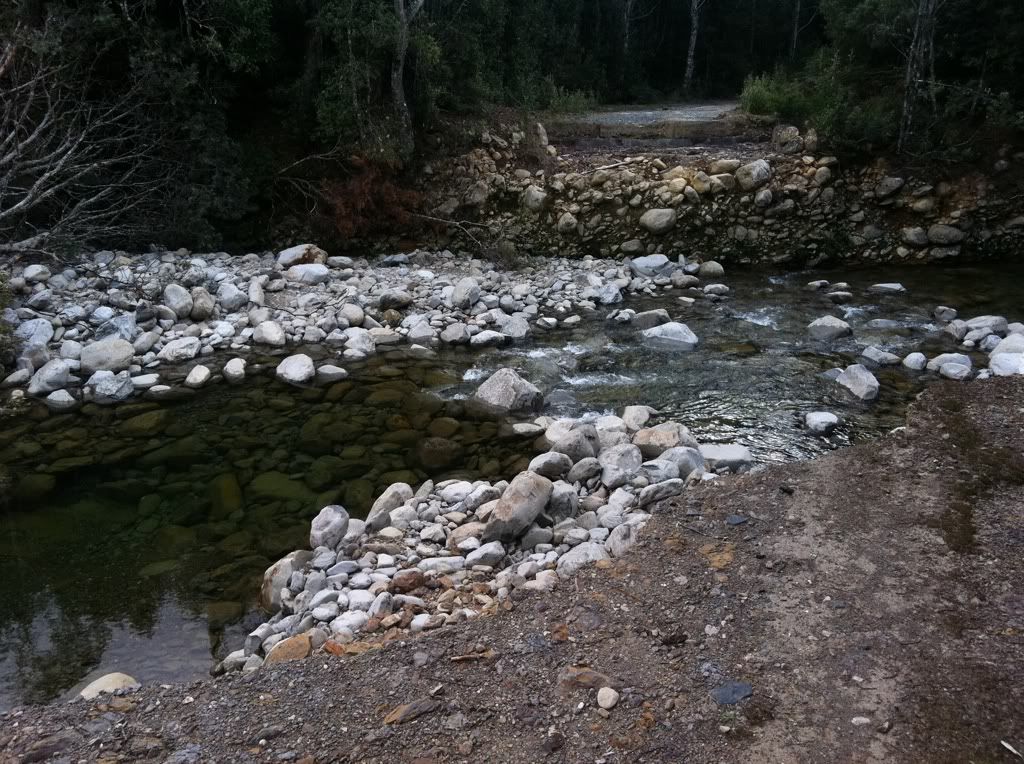
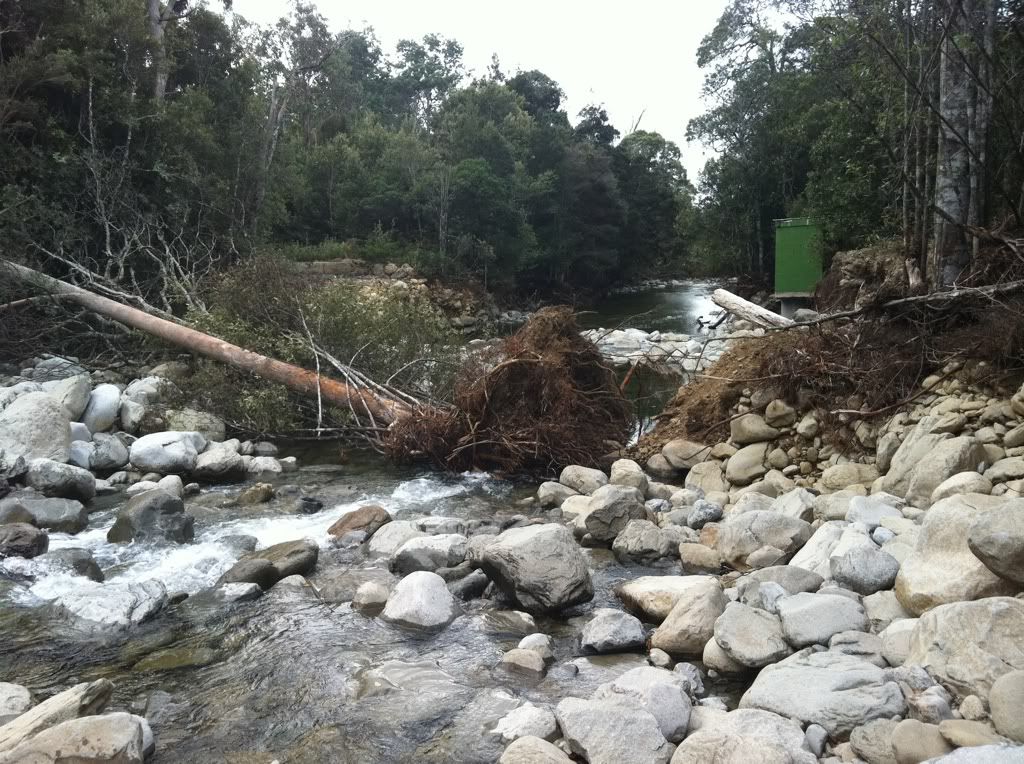
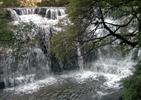
Went up smoko creek road tuesday the 14/02/12 was very pleased to see the sinkhole that has been preventing access is now all gone, yippy. New drainage pipes have been put in and road repaired. see photo
Now just need bridges fix so can get to stone hut and bastian cascades without all that walking on the road thats so boring before you finally get to the start of the track.
Now just need bridges fix so can get to stone hut and bastian cascades without all that walking on the road thats so boring before you finally get to the start of the track.
- Attachments
-
- smoko creek rd 1.jpg (108.92 KiB) Viewed 31876 times
-
- smoko creek rd 2.jpg (150.85 KiB) Viewed 31876 times
Recent walks, Lobster Falls, Rinadeena Falls, Bakers Beach and the Nob, Shadow Lake Circuit , Montezuma Falls, Holwell
-
chow - Nothofagus gunnii
- Posts: 10
- Joined: Wed 09 Feb, 2011 1:53 pm
- Location: Deloraine
- Region: Tasmania
- Gender: Female
Re: Meander Falls Road Access
![]() by GerryDuke » Sat 18 Feb, 2012 10:52 pm
by GerryDuke » Sat 18 Feb, 2012 10:52 pm
Thanks Chow. Nice to know.
Yes, it would be nice if the bridges could be fixed. I can never understand the 'brush off' we get when questioning the blaming the lack of 'funding' to fix the problem. Why can't funding for the 'controversial' 3 capes track be diverted to fix this problem and simply delay that project for a short period? I have always maintained that the Meander Forest Reserve at least should be a National Park and as such attract attract funding from that source to fix contingencies that arise such as this. This is too important and pristine an area to be closed down to tourists for a long period of time.
Gerry
-
GerryDuke - Athrotaxis cupressoides

- Posts: 403
- Joined: Sun 18 May, 2008 12:04 am
- Location: KINGSTON BEACH, TASMANIA
- ASSOCIATED ORGANISATIONS: Operator of www.TouringTasmania.info web site
- Region: Tasmania
- Gender: Male
Re: Meander Falls Road Access
![]() by clarence » Fri 06 Jul, 2012 8:26 pm
by clarence » Fri 06 Jul, 2012 8:26 pm
Let's be grateful they've at least repaired one of these access roads. It was probably two years at least since the Smoko Road was safely passable to vehicles.
I'm no fan of Forestry Tasmania generally, but given the cost of replacement of the two concrete bridges over Meander River and Mother Cummings Rivulet, I can understand if they are in no rush to fix them. I would doubt that whether it was funded by PWS, FT or general state government coffers that it would make any difference to how quickly the access to Meander Falls gets reintated.
In the meantime park at the first washed out bridge to access the Bastion Cascades/Stone Hut track (this will involved about 0.5km extra walking compared to when the bridge was there) or drive up to end of Smoko Rd and take your pick of three excellent walks. The Dell Track to the foot of Bastion Bluff was recently re-cleared and cairned too so now it is a negotiable route rather than a scrub bash.
Clarence
- clarence
- Athrotaxis cupressoides
- Posts: 327
- Joined: Sun 12 Feb, 2012 7:52 pm
- Region: Tasmania
- Gender: Male
Re: Meander Falls Road Access
![]() by GerryDuke » Fri 06 Jul, 2012 9:09 pm
by GerryDuke » Fri 06 Jul, 2012 9:09 pm
The issue here is the crossing of Mother Cummings Rivulet after rain when you would want to visit Bastion Cascades. Although it is only another .5 Kms to the quarry car park, it is a long walk to the start of the tracks from there along the road which can be passed by 4WD and even 2WD. Access to the cascades is very restricted without the bridge if the rivulet cannot be negotiated on foot.
GD
GD
-
GerryDuke - Athrotaxis cupressoides
- Posts: 403
- Joined: Sun 18 May, 2008 12:04 am
- Location: KINGSTON BEACH, TASMANIA
- ASSOCIATED ORGANISATIONS: Operator of www.TouringTasmania.info web site
- Region: Tasmania
- Gender: Male
Re: Meander Falls Road Access
![]() by jackson_turner1 » Thu 16 Aug, 2012 6:42 pm
by jackson_turner1 » Thu 16 Aug, 2012 6:42 pm
I am confused to where the Meander Falls are, hearing about the different road blocks, Mother Cummings Falls and on another site Smoko Falls is in fact a part of the Meander Falls is all VERY CONFUSING
Can anyone post some topography mapping (even Google earth) as to the different falls within the area and tracks to get to thees falls. Would be MUCH appreciated.
Can anyone post some topography mapping (even Google earth) as to the different falls within the area and tracks to get to thees falls. Would be MUCH appreciated.
- jackson_turner1
- Nothofagus gunnii
- Posts: 17
- Joined: Wed 15 Aug, 2012 8:01 pm
- Region: Tasmania
- Gender: Male
Re: Meander Falls Road Access
![]() by walkinTas » Fri 17 Aug, 2012 8:39 am
by walkinTas » Fri 17 Aug, 2012 8:39 am
Here is a quick version on old maps.
The full map of Tassie waterfalls is on the Wiki.
There is some more discussion and a similar map over here --> viewtopic.php?f=3&t=2038&p=20305&hilit=dixon+track#p20305
- Old Maps - lots of inaccuracies, but will give you a start.
The full map of Tassie waterfalls is on the Wiki.
There is some more discussion and a similar map over here --> viewtopic.php?f=3&t=2038&p=20305&hilit=dixon+track#p20305
- walkinTas
- Lagarostrobos franklinii
- Posts: 2934
- Joined: Thu 07 Jun, 2007 1:51 pm
- Region: Tasmania
52 posts
• Page 1 of 2 • 1, 2
Return to TAS Trip Reports & Track Notes
Who is online
Users browsing this forum: No registered users and 10 guests