Mt Pillinger June 2011

Trip reports, stories, track notes. Multiple/large photos are OK in this forum.
Forum rules
Posting large/multiple images in this forum is OK. Please start topic titles with the name of the location or track.

For topics focussed on photos rather than the trip, please consider posting in the 'Gallery' forum instead.

This forum is for posting information about trips you have done, not for requesting information about a track or area.

Mt Pillinger June 2011

Postby kurt » Sun 26 Jun, 2011 12:30 pm

Decided to walk Mt Pillinger yesterday, day wasn’t great but better then today! Track was a bit funny to find and took some wrong turns but got there in the end thankyou tastrekker for your directions.

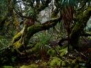
Start of the track just before the national park sign
2.JPG


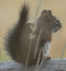
target staring at me in the distance
4.JPG


T-junction stick marker left Pillinger right back to ARM River
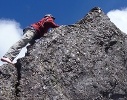
6.JPG


Little closer
7.JPG


View from the top
8.JPG


More on FB http://www.facebook.com/media/set/?set=a.10150294930037813.384252.594792812
User avatar
kurt
Nothofagus gunnii
Nothofagus gunnii
 
Posts: 11
Joined: Fri 28 Jan, 2011 2:21 pm
Region: Tasmania
Gender: Male

Re: Mt Pillinger June 2011

Postby kurt » Sun 26 Jun, 2011 12:35 pm

User avatar
kurt
Nothofagus gunnii
Nothofagus gunnii
 
Posts: 11
Joined: Fri 28 Jan, 2011 2:21 pm
Region: Tasmania
Gender: Male

Re: Mt Pillinger June 2011

Postby MichaelP » Sun 26 Jun, 2011 6:44 pm

I would have expected to see more snow in the photo from the top! Was there much out of the field of view of the camera?
User avatar
MichaelP
Atherosperma moschatum
 
Posts: 97
Joined: Fri 03 Jul, 2009 3:14 pm
Location: From Launceston, currently studying in Melbourne
Region: Victoria
Gender: Male

Re: Mt Pillinger June 2011

Postby Nuts » Sun 26 Jun, 2011 9:46 pm

Hi Kurt, nice walk, your link isnt working (for me)?
Just curious, what happened here :) :
Picture 5.png
Picture 5.png (68.3 KiB) Viewed 7304 times
User avatar
Nuts
Lagarostrobos franklinii
 
Posts: 8638
Joined: Sat 05 Apr, 2008 12:22 pm
Region: Tasmania

Re: Mt Pillinger June 2011

Postby pazzar » Sun 26 Jun, 2011 9:56 pm

that would be a track that leads to Maggs spur 17 I believe, although further down it turns and heads around towards lake leonis so I'm not sure. It is a very well marked track and looks like it gets a lot of use.
"It's not what you look at that matters, it's what you see."
User avatar
pazzar
Lagarostrobos franklinii
 
Posts: 2743
Joined: Thu 09 Jul, 2009 5:22 pm
Location: Hobart
Region: Tasmania
Gender: Male

Re: Mt Pillinger June 2011

Postby Nuts » Sun 26 Jun, 2011 10:37 pm

Yer, i'd say so, ive been down/up that way, was just wondering what kurt was up to :D

(tracks everywhere! there is a 3rd track over the next spur past L Mcoy, i think it ends on the cliffs (?) but it makes a nice circuit with a short bash through to the Pillinger/ track)
User avatar
Nuts
Lagarostrobos franklinii
 
Posts: 8638
Joined: Sat 05 Apr, 2008 12:22 pm
Region: Tasmania

Re: Mt Pillinger June 2011

Postby kurt » Mon 27 Jun, 2011 4:07 pm

I took a completely wrong turn, but decided stuff it see what's down here the track was very well marked and took this shot before turning around:

IMG_3463.JPG
User avatar
kurt
Nothofagus gunnii
Nothofagus gunnii
 
Posts: 11
Joined: Fri 28 Jan, 2011 2:21 pm
Region: Tasmania
Gender: Male

Re: Mt Pillinger June 2011

Postby kurt » Mon 27 Jun, 2011 4:10 pm

MichaelP wrote:I would have expected to see more snow in the photo from the top! Was there much out of the field of view of the camera?


no hardly any snow on Pillinger itself only in shaded spots here and there.

My FB link should be working now.
User avatar
kurt
Nothofagus gunnii
Nothofagus gunnii
 
Posts: 11
Joined: Fri 28 Jan, 2011 2:21 pm
Region: Tasmania
Gender: Male

Re: Mt Pillinger June 2011

Postby Nuts » Mon 27 Jun, 2011 6:25 pm

kurt wrote:I took a completely wrong turn, but decided stuff it see what's down here the track was very well marked and took this shot before turning around


It just heads out to another road Kurt, used by packhaulers and some locals. A bit further but not as steep, probably not worth using unless carrying heavy loads.


Some really nice spagnum glades and stands of very old pencil pines not much further down the valley from your pic... if your into that sort of thing :)

Anyhow.. yes the link works, good effort & bothering to post, well done.
User avatar
Nuts
Lagarostrobos franklinii
 
Posts: 8638
Joined: Sat 05 Apr, 2008 12:22 pm
Region: Tasmania

Re: Mt Pillinger June 2011

Postby sirius Tas » Wed 29 Jun, 2011 1:37 pm

Kurt,
That track you walked along for a look see comes out at Maggs Spur Road 17/2.....which is the easiest track to Pillinger...as it avoids the 150m climb on the Arm....which is why the start off the Arm track isn't easy to find as it doesn't get much use I expect.
Not far from it's start(Maggs 17/2) it branches south to Lake McCoy....and can be connected back over to the Pillinger track(no marked trail)...to complete a circuit.
After a day's walk everything has twice its usual value.
User avatar
sirius Tas
Athrotaxis cupressoides
 
Posts: 181
Joined: Fri 03 Oct, 2008 2:18 pm
Location: Ulverstone
Region: Tasmania
Gender: Male

Re: Mt Pillinger June 2011

Postby CEyre » Thu 30 Jun, 2011 9:34 pm

Hi Kurt
The image appears similar to a photo that i have of the track to Lake McCoy that is about 800m further on, very pretty. The track to Mt Pillinger is at a junction that you may have missed as short distance after the second small rough bridge on the track that you were on. Lake McCoy is worth a visit though Mt Pillinger has majestic views....on fine days.
CEyre
Nothofagus cunninghamii
 
Posts: 9
Joined: Wed 09 Dec, 2009 9:45 pm
Region: Tasmania
Gender: Male


Return to TAS Trip Reports & Track Notes

Who is online

Users browsing this forum: No registered users and 9 guests