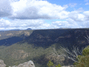
Last Saturday I set off to discover a piece of the Southern Blue mountains known as the jooriland(s). I had only previously taken in panoramic views of the area from up on Belloon pass, it was here my interest where piqued and couldn’t wait to get amongst it proper.
Parking just inside a farm gate past some cattle yards the car was locked and bag shouldered and I was on my way by 9am, a latish start for me but this trip was purely about the exploration and not about kilometres burned in fact I didn’t really have a hard and fast route target except to maybe cross over the Mt Egan fire trail and loop around returning via Goodfellows cr.
The descent into the valley via Burnt flat creek looked pretty hectic on the map and it didn’t let me down…A quad killing Klm of knee jarring agony had me walking down the hill backwards! Luckily the surface being nice and even seen me hit the bottom with no mishaps and I had to quickly erase the thought of what it’s going to like going back up. From here I wound my way around the base of the
Wanganderry walls on a nice wide fire trail that was totally covered in dog tracks. There must be a huge population roaming these hills? No sign of human prints in the dry dust or any rubbish at all really, the only sign I seen of people was a plastic fuel Gerry can that must have toppled from a ute. It was laying smack in the middle of a bend so I moved it the side of the road and continued on.
By 11.30 I was at the flying fox on the Wollondilly. A neat little hut stood proud on the hill here complete with clean bunks and a brick BBQ with a good supply of timber. It was locked tight and government owned so I’m assuming not for public use…but I did use their tank water which was probably caught on CCTV and I’ll be billed in accordance at a later date. I headed down stream for a while and crossed the Wollondilly without even removing my shoes this was going to be an ominious sign as to just how dry the area was. I spied a road heading up to what I assumed was the ridge I wanted to be on but decided not to take it as I wanted to check the now abandoned homes a little up the way.
Cruising along the sheep wash rd now and absolutely covered in fricken farmers friends I came to the settlement, again no humans in sight but I could see the grass had not long ago been slashed around the houses, I guess a fire precaution only as the houses were totally dilapidated. Past here I turned left onto the Loop Rd, which contrary to it’s name must be totally out of the loop…it was nearly gone in parts but easy to follow as you only need to keep amongst the weeds which love to grow out of old tyre ruts. As the ridge climbed higher the timber got thicker and my legs got heavier I decided to camp up for the night. I picked a dam just off to my left on the road which had a steel pig trap next to it (2 of which I seen on this walk) it made a excellent hanging rack. Only 3pm by this time I set up and had some dinner and with the last remaining rays of light had a wander and took in the views to the S/W, found where I would begin in the morning and got snoozing.
SNOOZING! *&%$#! creaking old gum near the tent made it sound like I was in the hull of a ship all night but it meant I was up and at it for an early start. And by 7am I was away, back on the loop road it was only a short distance to where the Mt Egans fire trail branches off to the left. I followed this a couple of klms uphill to the top of a hill where I could see a faint track that branched off to my left I decided to carry on straight a short distance down the other side of the hill because the topo had another hut shown in a gully. I find the hut across a creek (dry) situated up the back of a clearing…now this would have been remote living in any man’s book back in the day.
A quick examination of the hut and I headed back to the junction and down the Mt Egan trail…but not for long. After about 200 mtrs the trail totally petered out and turned into head high grass and general scrub, I bashed through this about another 200 mtrs until I struck an old farm fence. I hoped the fence and after a bit it opened up to quiet a big clearing which was obviously a homestead or yards of some sort in it’s day, plenty of cut timbers and the odd strategically placed bushrock garden bed gave me this impression. Searched high and low for a track but found only false leads and animal pads so I decided not to get any deeper and simply head home the way I came.
Now back tracking goes against every moral fibre in body but on this occasion it wasn’t a bad thing at all. All the views I’d seen going up the ridge were merely glances over the shoulder so coming down allowed me to get a whole new perspective and really savour the sights as the road was level enough not to command your total attention. About halfway down the loop Rd I came across the highlight of the trip…A Dingo emerged roughly 4 mtrs in front of me right in the middle of the road. Now I didn’t get a chance to run a DNA test on him but he looked as pure as the driven snow to me, full winter coat, looking as big as a grey wolf. Finally my search for spiritual enlightenment had come full circle as me and my blood totem faced off in a unspoken ritual that only byamge himself could possible comprehend….well maybe not but it was a cool moment.
Back down at the huts and I gave then a proper going over as I rushed through on my way up and then back to the flying fox hut where I replenished my water supplies and cooked my lunch on their flash BBQ. Back on the fire trail now and there is a stretch of the road that run almost directly into the North face of Bonnum pic, the most impressive view of it I thought of the whole trip. As I neared it I thought, ”yeah It kind of does look like a stairway to heaven” (hopefully that pun gets picked up by somebody out there).
From here on in it was pretty standard walking back to the car although somebody (thing?) had moved the Gerry can! My feet were really starting to play up by now which I thought would have been the case where heaps of road bashing takes place. So before long I find myself at the base of hells gate, ie the Burnt flat Ck hill here I just dropped it back to 2nd gear and grinded my way back to the car and all was good.
Fin.
PS Google earthed it just before, I was literally a stones throw away from the base of Mt Egan itself…DOH! With a bit of perseverance I probably would of easily found the track. Ah what the hell, there’s always next weekend, right?
Jooriland jaunt.
Forum rules
Posting large/multiple images in this forum is OK. Please start topic titles with the name of the location or track.
For topics focussed on photos rather than the trip, please consider posting in the 'Gallery' forum instead.
This forum is for posting information about trips you have done, not for requesting information about a track or area.
9 posts
• Page 1 of 1
Jooriland jaunt.
![]() by puredingo » Wed 22 May, 2013 6:04 pm
by puredingo » Wed 22 May, 2013 6:04 pm
Last edited by puredingo on Fri 24 May, 2013 5:30 pm, edited 1 time in total.
- puredingo
- Athrotaxis selaginoides

- Posts: 1270
- Joined: Mon 13 Feb, 2012 6:54 am
- Region: New South Wales
Re: Jooriland jaunt.
![]() by Grabeach » Wed 22 May, 2013 8:22 pm
by Grabeach » Wed 22 May, 2013 8:22 pm
Decades ago wandered out and down Bonnum Pic then back the same way, so have the 1st Ed. Hilltop map (without the road down Burnt Flat Ck). Round about that same time I also went part way down to the Goodfellows Ck / Wollondilly junction from the tunnel and returned, so have the Barrallier map. That's about all I know of the area. Neither of those maps show Mt Egan, a flying fox nor any of the road names you mention. I'm lost. I'm not sure I'm even on the same map! Did you end up at Goodfellows Ck? Any chance of a GR, say for the the flying fox, so I may re-orientate myself?
- Grabeach
- Athrotaxis cupressoides

- Posts: 309
- Joined: Wed 12 Oct, 2011 2:09 pm
- Region: New South Wales
- Gender: Male
Re: Jooriland jaunt.
![]() by kanangra » Wed 22 May, 2013 8:31 pm
by kanangra » Wed 22 May, 2013 8:31 pm
Puredingo. Loved that report as always. You were indeed very close. I too lost the track in the same spot and ended up bushbashing from behind the hut to the top of the hill where I picked up the track again. I marked the hut you mention on my map at Bindook: 437:121. Very dilapidated. I think it is just outside the park boundary. No track is marked on the map through there but there definitely is one eventually if you persevere. When I got home I made a note in the margin of my Bindook sheet: "N.B. Track indistinct here. Main track goes down hill and terminates at old shack. One to Mt Egan goes up to left."
A reason to go back?
A reason to go back?
- kanangra
- Athrotaxis selaginoides
- Posts: 1335
- Joined: Sun 25 May, 2008 3:52 pm
Re: Jooriland jaunt.
![]() by michael_p » Wed 22 May, 2013 8:59 pm
by michael_p » Wed 22 May, 2013 8:59 pm
Good read puredingo. That is one area I would like to explore one day.
Cheers,
Michael.
Cheers,
Michael.
One foot in front of the other.
-
michael_p - Athrotaxis selaginoides
- Posts: 1378
- Joined: Sun 15 Nov, 2009 6:58 pm
- Location: Macarthur Region of Sydney.
- Region: New South Wales
- Gender: Male
Re: Jooriland jaunt.
![]() by puredingo » Wed 22 May, 2013 9:39 pm
by puredingo » Wed 22 May, 2013 9:39 pm
Thanks boys, for some reason the first 2 paragraphs got condensed together and a few of the sentences mixed up? So it doesn't make much sense....
Ah computers, why do they hate me so much?
Grabeach, I'll check the map in the morning and try and get a GR for you re the flying fox etc.
Ah computers, why do they hate me so much?
Grabeach, I'll check the map in the morning and try and get a GR for you re the flying fox etc.
- puredingo
- Athrotaxis selaginoides
- Posts: 1270
- Joined: Mon 13 Feb, 2012 6:54 am
- Region: New South Wales
Re: Jooriland jaunt.
![]() by michael_p » Thu 23 May, 2013 10:40 am
by michael_p » Thu 23 May, 2013 10:40 am
Grabeach wrote:Any chance of a GR, say for the the flying fox, so I may re-orientate myself?
Nattai 8929-1S (3rd Edition) GR474098 (or thereabouts).
Grabeach wrote:Mt Egan
Bindook 8929-4S (3rd Edition) GR434118 (or thereabouts).
You guys should have a look at the LPI's SIX website. Heaps of tracks not on the topo maps are on the SIX site. Personally find this much better than fiddling around with Google Maps/Earth. Website link: http://maps.six.nsw.gov.au/. Click on the "Map Contents" button (top right corner) and select "Dynamic Labels", then click on "Basemaps" button and set base map to "NSW Map".
Cheers,
Michael.
EDIT: I should note that the Flying Fox is on the topographic map but not the SIX website.
One foot in front of the other.
-
michael_p - Athrotaxis selaginoides
- Posts: 1378
- Joined: Sun 15 Nov, 2009 6:58 pm
- Location: Macarthur Region of Sydney.
- Region: New South Wales
- Gender: Male
Re: Jooriland jaunt.
![]() by jackhinde » Thu 23 May, 2013 7:52 pm
by jackhinde » Thu 23 May, 2013 7:52 pm
i am sorry i couldn't come now (and people think i give short notice!), sounds like a good trip from you fantastic report.
It is a nasty descent/ascent isn't it, maybe next time you might want to borrow the key for the gate off steve...
It is a nasty descent/ascent isn't it, maybe next time you might want to borrow the key for the gate off steve...
- jackhinde
- Athrotaxis cupressoides
- Posts: 324
- Joined: Wed 23 Nov, 2011 5:01 pm
- Location: Kangaroo Valley
- Region: New South Wales
- Gender: Male
Re: Jooriland jaunt.
![]() by puredingo » Fri 24 May, 2013 5:47 pm
by puredingo » Fri 24 May, 2013 5:47 pm
Haha, yeah Jack it was a off the cuff type of walk so i couldn't really give you any details of time, route or even destination as i didn't know it myself, but yeah the night before is short notice.
pretty keen to get out there again soonish so we'll get together and hunt down that pesky Mt Egan trail yet.....and if we can convince K to come along we'll be able to do it with eyes shut (I'll just have to get my hands on a pint of cheetahs blood so I can keep up).
PS I edited the original report so it should make a bit more sense now...just navigate around the atrocious grammar and spelling and you'll be apples (St John Bosco Engadine has a lot to answer for!)
- puredingo
- Athrotaxis selaginoides
- Posts: 1270
- Joined: Mon 13 Feb, 2012 6:54 am
- Region: New South Wales
Re: Jooriland jaunt.
![]() by Onestepmore » Sat 15 Jun, 2013 6:52 pm
by Onestepmore » Sat 15 Jun, 2013 6:52 pm
Good report
Thanks!
Somewhere else to go on a weekend with hubby
Thanks!
Somewhere else to go on a weekend with hubby
We can learn a lot from crayons. They come in different shapes and colours, but they all have to live in the same box
-

Onestepmore - Athrotaxis selaginoides
- Posts: 1329
- Joined: Mon 02 Jul, 2012 11:33 am
- Location: Picton
- Region: New South Wales
- Gender: Female
9 posts
• Page 1 of 1
Return to NSW & ACT Trip Reports & Track Notes
Who is online
Users browsing this forum: No registered users and 25 guests