I found myself having a spare day yesterday and so after dropping my daughter and her husband off at the airport I decided to continue down to the Shoalhaven area. I parked at the top of Badgery's Lkt. It was freezing with thick fog ruling out any chance of a view. I then set off on the long trek back around via the road to Long Pt. Lkt. A distance of about 15kms. When I arrived the valley was still blanketed in fog and mist so I set off down Mc Callums Track. This is a very well made track that provides a well graded route to the valley of the Shoalhaven River far below. Once down I head off across McCallums Flat, this former grazing land is slowly revegetating. I stayed on the northern side till the river cut under very steep slopes below the lookout. Here I crossed just above a rapid in water that was thigh deep. It was running beautifully clear and ice cold. Once across I made very good going on the southern side for quite some distance before crossing back to the northern side at a shallow section. From there I stayed on the northern side all the way to Badgery's crossing. Mainly the going was good with just a few spots where it was necessary to clamber over rocks. I thought about crossing back a couple of times but no easy crossing presented itself and so I just stayed where I was. At the foot of Badgery's Spur I met another walker who had just walked down from the lookout. He was going to set up camp there the night even though it was not yet midday. He seemed surprised when I told him where I'd come from. We chatted for a while then I set off up the spur. I took it in one pull arriving at the top 45 minutes later. It was not quite 1:00PM.
This had been a splendid little trip that I had thought would take rather longer. Not knowing what to expect I had allowed more time than I needed. The river section took only a little over 2 hours.
I was very pleasantly surprised by how well preserved the river banks were with beautiful grassy sections common and weeds and other rubbish quite rare. I also noted the steep descent off Sparkes Buttress on the southern side of the gorge. I could now see why I had such trouble descending there a couple of years back. The route gets steeper the closer it gets to the river. If anything, on descent, I would trend to the right, that is to say down stream, for the most gradual descent.
I strongly recommend this little excursion for those who like wild river scenery. The trip could readily be extended by camping on one of the many grassy river flats en route. I will try and post a few pics when I get to work on Monday.
K.
Shoalhaven Shuffle.
Forum rules
Posting large/multiple images in this forum is OK. Please start topic titles with the name of the location or track.
For topics focussed on photos rather than the trip, please consider posting in the 'Gallery' forum instead.
This forum is for posting information about trips you have done, not for requesting information about a track or area.
12 posts
• Page 1 of 1
Shoalhaven Shuffle.
![]() by kanangra » Sun 14 Jun, 2015 3:01 pm
by kanangra » Sun 14 Jun, 2015 3:01 pm
- kanangra
- Athrotaxis selaginoides

- Posts: 1335
- Joined: Sun 25 May, 2008 3:52 pm
Re: Shoalhaven Shuffle.
![]() by Lizzy » Sun 14 Jun, 2015 6:38 pm
by Lizzy » Sun 14 Jun, 2015 6:38 pm
Nice one  you certainly don't muck around! Looking forward to the pics
Last edited by Lizzy on Sun 14 Jun, 2015 9:40 pm, edited 1 time in total.
-
Lizzy - Athrotaxis selaginoides
- Posts: 1074
- Joined: Mon 16 Nov, 2009 1:13 pm
- Region: New South Wales
- Gender: Female
Re: Shoalhaven Shuffle.
![]() by clarence » Sun 14 Jun, 2015 7:00 pm
by clarence » Sun 14 Jun, 2015 7:00 pm
Great spot down there, and that is only the "tip of the iceberg" so to speak. The Shoalhaven is a highly underrated area for walking, and possibly my favourite place to walk. The off track walking around there has so many possibilites both downstream and upstream. Stories like this give me the encouragement to get back there soon.
Clarence
Clarence
- clarence
- Athrotaxis cupressoides

- Posts: 327
- Joined: Sun 12 Feb, 2012 7:52 pm
- Region: Tasmania
- Gender: Male
Re: Shoalhaven Shuffle.
![]() by kanangra » Mon 15 Jun, 2015 8:14 am
by kanangra » Mon 15 Jun, 2015 8:14 am
Clarence I couldn't agree more. The more I see the more I like. Already planning my next foray. I think it might be time to dust off the pack raft.
K.
K.
- kanangra
- Athrotaxis selaginoides
- Posts: 1335
- Joined: Sun 25 May, 2008 3:52 pm
Re: Shoalhaven Shuffle.
![]() by clarence » Mon 15 Jun, 2015 8:26 am
by clarence » Mon 15 Jun, 2015 8:26 am
If you want any tips on good spots PM me. Great spot to packraft/lilo.
Clarence
Clarence
- clarence
- Athrotaxis cupressoides
- Posts: 327
- Joined: Sun 12 Feb, 2012 7:52 pm
- Region: Tasmania
- Gender: Male
Re: Shoalhaven Shuffle.
![]() by kanangra » Mon 15 Jun, 2015 8:30 am
by kanangra » Mon 15 Jun, 2015 8:30 am
Here are a couple of shots from the trip.
More to follow.
K.
- Valley scene on the way in down Long Point before the heavy mist and fog had burnt off.
- Camp site at the bottom of Long Point.
- Very pleasant going through scattered timber on the way to McCallums Flat.
- Mc Callums Flat
- I made the first crossing above this small rapid.
More to follow.
K.
- kanangra
- Athrotaxis selaginoides
- Posts: 1335
- Joined: Sun 25 May, 2008 3:52 pm
Re: Shoalhaven Shuffle.
![]() by kanangra » Mon 15 Jun, 2015 9:52 am
by kanangra » Mon 15 Jun, 2015 9:52 am
Here are a few more.
TBC
K.
- A river scene.
- River reflections
- A calm reach.
- Camp site at the base of Badgerys
- View downstream taken on the way up Badgerys.
TBC
K.
- kanangra
- Athrotaxis selaginoides
- Posts: 1335
- Joined: Sun 25 May, 2008 3:52 pm
Re: Shoalhaven Shuffle.
![]() by kanangra » Mon 15 Jun, 2015 11:49 am
by kanangra » Mon 15 Jun, 2015 11:49 am
Last ones.
This is the route I had taken from the southern rim to descend into the gorge on a previous trip. By looking at those rock ribs I can see I should have trended more to the right on that descent. The maps show a track there but there certainly isn't one on the southern side.
It certainly is great country.
K.
- Sparkes Buttress
This is the route I had taken from the southern rim to descend into the gorge on a previous trip. By looking at those rock ribs I can see I should have trended more to the right on that descent. The maps show a track there but there certainly isn't one on the southern side.
- View upstream showing Tryers Gorge entering on the southerm side and the Bungonia limestone visible through the low saddle in the middle distance.
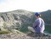
- View of Mc Callums Flat taken later in the day after all the fog and mist had lifted. Taken from the Long Pt. Lkt.
- View down river showing the lie of the land on my trip. The Badgery's Spur is visible in the distance.
It certainly is great country.
K.
- kanangra
- Athrotaxis selaginoides
- Posts: 1335
- Joined: Sun 25 May, 2008 3:52 pm
Re: Shoalhaven Shuffle.
![]() by DarrenM » Mon 15 Jun, 2015 5:23 pm
by DarrenM » Mon 15 Jun, 2015 5:23 pm
Great pics of a fantastic area mate. Nice one.
- DarrenM
- Athrotaxis cupressoides
- Posts: 465
- Joined: Tue 19 Oct, 2010 7:10 pm
- Location: Sydney
- Region: New South Wales
- Gender: Male
Re: Shoalhaven Shuffle.
![]() by puredingo » Mon 15 Jun, 2015 7:15 pm
by puredingo » Mon 15 Jun, 2015 7:15 pm
Excellent K....What was the mileage on that romp?
- puredingo
- Athrotaxis selaginoides
- Posts: 1270
- Joined: Mon 13 Feb, 2012 6:54 am
- Region: New South Wales
Re: Shoalhaven Shuffle.
![]() by kanangra » Tue 16 Jun, 2015 7:37 am
by kanangra » Tue 16 Jun, 2015 7:37 am
I know the road trip from lookout to lookout was about 15km according to the road signs. ( 7km from turn off out to Badgery's Lkt and 6 km from turn off out to Long Pt Lkt with about 3km between the two turn offs.) I think the sign at the start said it was 4kms down Long Pt and I reckon it would be about 3km up Badgerys. The distance along the river is more difficult to estimate. It took me just over two hours of reasonable going so maybe about 6-7 km? So about 28 km. all up give or take?
K.
K.
- kanangra
- Athrotaxis selaginoides
- Posts: 1335
- Joined: Sun 25 May, 2008 3:52 pm
Re: Shoalhaven Shuffle.
![]() by jeremy089786 » Mon 06 Jul, 2015 4:57 pm
by jeremy089786 » Mon 06 Jul, 2015 4:57 pm
Hi kanangra,
Nice to see the river at lower levels. That loop of river at the bottom of Mc Callums is one of the best I have found for pack raft skill building when it is at high water.
Also, +1 to the Shoalhaven being incredibly underrated!
Nice to see the river at lower levels. That loop of river at the bottom of Mc Callums is one of the best I have found for pack raft skill building when it is at high water.
Also, +1 to the Shoalhaven being incredibly underrated!
- jeremy089786
- Athrotaxis cupressoides
- Posts: 190
- Joined: Wed 22 Dec, 2010 6:05 pm
- ASSOCIATED ORGANISATIONS: WilderWheels
- Region: New South Wales
- Gender: Male
12 posts
• Page 1 of 1
Return to NSW & ACT Trip Reports & Track Notes
Who is online
Users browsing this forum: No registered users and 25 guests