Had a day in and around the South Arthur River Forest Drive, very pleasant.
Well signposted and easy to find places.
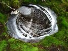
Enjoyed both the sinkhole and rainforest walks at Julius River.
Lake Chisholm walk was short and sweet but picturesque.
I have posted a picture from Dempster lookout that has been on before and i couldn't believe the Button Grass growth. The hills in the distance I take are on Norfolk Range, could someone correct me if this is not correct.
Rapid River road is still closed.
We didn't do the walk down to Beckett Falls as we didn't let anyone know where we were going and didn't wish to have a mishap on the way down and not be found (funny how you become more careful with age).
This brings me to a question - the bit at the top where it start to descend at a reasonably sharp rate and goes around the rocky narrow ledge, is that the worst part of the descent? From what I could gather that appears to be the worst of it and if so we'll let someone know next time and do the whole trip to the bottom.
Lots of good fungi appearing already, might be a good year for it.
South of Arthur River
Forum rules
Please keep the width of embedded images (using [img] [/img] tags) in this forum to no more than 800 pixels wide (this will avoid them being clipped without notice by most users' window sizes). Attached images can be any resolution so long as the file size is no more than 1 MB (attachments will be displayed by the forums as thumbnails no larger than 800 pixels linked to the full-size image).
Please include a description of the pictures' content so that readers know what they're all about.
For topics focussed on narrative rather than the photos, please consider posting in one of the 'Trip Report' forums instead.
6 posts
• Page 1 of 1
South of Arthur River
![]() by Davo1 » Tue 26 Mar, 2013 9:05 am
by Davo1 » Tue 26 Mar, 2013 9:05 am
- Attachments
-
- A fresh in the Arthur
-
- Everywhere we looked, same colour, green, green and more green.
-
- Makes for an easy stroll
-
- My favourite, on the way in to Lake Chisholm, gotta fluke a good one now and again.
-
- Looking across Dempster Plains, I am assuming those hills are Norfolk Range?
- Davo1
- Athrotaxis cupressoides

- Posts: 359
- Joined: Sun 09 Dec, 2012 7:20 am
- Region: Tasmania
- Gender: Male
Re: South of Arthur River
![]() by Davo1 » Tue 26 Mar, 2013 9:14 am
by Davo1 » Tue 26 Mar, 2013 9:14 am
A few more
- Attachments
-
-
-
- Those hills again? Shame it was raining
-
- Seen a Platypus here but it was too quick to get a pic.
-
- Davo1
- Athrotaxis cupressoides
- Posts: 359
- Joined: Sun 09 Dec, 2012 7:20 am
- Region: Tasmania
- Gender: Male
Re: South of Arthur River
![]() by timburke68 » Thu 18 Apr, 2013 1:57 pm
by timburke68 » Thu 18 Apr, 2013 1:57 pm
Hi Davo,
wife and i have done the walk into Beckett falls, we did it without too much trouble, just have to be a little cautious in a couple of places and we are far from experienced bushwalkers. It is worth a look though quite impressive and the Rapid River road is only closed because of the bridge but i have driven over it twice since it been supposedly closed and the last time we were out we just crossed the river next to the bridge on the downstream side (river was down pretty low though). Tim
wife and i have done the walk into Beckett falls, we did it without too much trouble, just have to be a little cautious in a couple of places and we are far from experienced bushwalkers. It is worth a look though quite impressive and the Rapid River road is only closed because of the bridge but i have driven over it twice since it been supposedly closed and the last time we were out we just crossed the river next to the bridge on the downstream side (river was down pretty low though). Tim
- timburke68
- Nothofagus gunnii

- Posts: 24
- Joined: Fri 25 Feb, 2011 9:10 am
- Region: Tasmania
- Gender: Male
Re: South of Arthur River
![]() by tigercat » Thu 18 Apr, 2013 2:29 pm
by tigercat » Thu 18 Apr, 2013 2:29 pm
Great photos, thanks for posting.
Wilderness: restful and healing for the mind and spirit
-
tigercat - Athrotaxis selaginoides

- Posts: 1338
- Joined: Thu 29 Mar, 2012 8:21 pm
- Region: Tasmania
Re: South of Arthur River
![]() by Davo1 » Mon 29 Apr, 2013 6:49 pm
by Davo1 » Mon 29 Apr, 2013 6:49 pm
timburke68 wrote:Hi Davo,
the Rapid River road is only closed because of the bridge but i have driven over it twice since it been supposedly closed and the last time we were out we just crossed the river next to the bridge on the downstream side (river was down pretty low though). Tim
Thanks for the info on Beckett Tim.
Last two times we have to been Rapid River I wasn't game to cross either way - waayyyy too much water
- Davo1
- Athrotaxis cupressoides
- Posts: 359
- Joined: Sun 09 Dec, 2012 7:20 am
- Region: Tasmania
- Gender: Male
6 posts
• Page 1 of 1
Who is online
Users browsing this forum: No registered users and 22 guests