Thanks Tony.
I did get a couple into the new Bushwalk Australia calendar - but not from the Flinders.
I still think I need to learn how to use the camera a lot better yet.
Back to the trip:
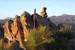
We gained the main ridgeline past Nintenta Peak by ascending a gully south of Mt Bell.
There were then 2 scrubby sections passing Mt Bell and then approaching Mt Falkland, but exhausted and thirsty- we finally got there.
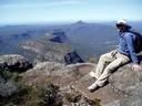
From the top we had views all around - to the NE was Patawarta Hill in the distance with Angorichina village and the dirt road from Parachilna to Blinman running past.
 Viewed 12586 times")
- From Mt Falkland looking NE
To the West and NW was the vast expanse of Lake Torrens - disappearing out of sight to the north.
There appeared to be no water in it from this angle - but i know there has been substantial water in it coming from the northern end this year.
[Panorama - click on it to enlarge]
 Viewed 12586 times")
- Lake Torrens with Parachilna "township" at the road junction
To the south the ABC range and the Heysen Range were close with Wilpena Pound and the Elder Range in the distance and mountains discernable down to Mt Arden close to Quorn
 Viewed 12586 times")
- View South - for a long way....
After a reasonable rest we started up again looking carefully for breaks to take us past the 2 cliff lines below - a task which wasn't too difficult in the end, but we did need patience.
There was still a long walk down the exit ridge and a very steep bump to arrive back at the Heysen Trail, cross it and walk down Wild Dog Creek to Angorichina.
There was water in Wild Dog Creek so we gathered some and processed with a puritab so that we could get a final drink in before getting back to the car.