We arrived at Mountain Creek picnic and camp area just right time for not pitching tent up in the dark. There were 2 or 3 cars before us and we had a chatty visitor. A few cars arrived a little late during the night.
The walking track signposts can be seen in the picnic and camping area and Mt Bogong track signpost located east of the visitor info tells us: 2 kms to the base of The Staircase and 8 kms to Mt Bogong.
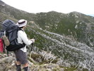
Generally speaking, the walk up via Eskdale Spur is less steep uphill than the Staircase, but the walk on Mountain Creek road is rather longer. We chose to walk up Staircase Spur and get down Eskdale Spur based on weather forecast and Allan’s wishes (ok on ups and not very ok on downs due to a recent ankle surgery). Unlike Allan, I am rather slow at ups specially if loaded with gear and days of food.
The walk from the camp area to the base of The Staircase is less than 2 kms on a gravel 4WD road and a walker’s intention book can be found at the base. It’s useful for park ranger to know your walk plan and vehicle regro so that a search party can be sent in for a missing case that is reported.
The foot track from the base of The Staircase to Mt Bogong can be divided into 3 sections:
The start of The Staircase – Bivouac refuge: about 3 kms
It is a steep long walk up to the hut which is located on top of an open spur and its there for emergency. There are few good tentsites on the eastern side of the hut. If late start, this would be an ideal for spending the night. Just to recall, a contact to a park ranger is needed for a report on the leakage of the water tank tab.
Bivouac refuge – the start of a pole line: about 1.5 kms
The track continues on behind the hut. It was a nice and pleasant a walk up skirting around a rocky spur above the tree line. The views at this point was amazing with the ranges to the north, Eskdale Spur to the east and Little Bogong to the west.
Final climbing Staircase Spur: about 1.5 kms
Follow the pole line uphill on the open spur for about 700 m, then pass a monument where three skiers died during a heavy snow storm in 1943. Fine weather can offer stunning views of Mt Bogong to the south, and West Peak to the west. When the crest of the ridge is reached, most of the hard work have been done. Mt Bogong summit,1986m, the highest peak in Victoria is just about an easy100m walk to the west.
Packs were left here for a side trip to the summit cairn and West Peak; but got only to Hooker Plateau and returned. While i was keen on heading to Bogong Creek to check out the availability of water (Original plan was to camp here on first day), Allan did not want to go further because we didn’t have gear with us.
Back to the summit cairn we took a couple of photos, then headed back to the junction to reunite with our packs, then found a sheltered spot from the sun and the wind for late lunch near Hell Gap with views down spurs to the south and southwest.
After lunch, we followed a pole route leading south, then southeast for our destination, Cleve Cole Hut in Camp Valley. It is a pleasant 3 km walk on the high plain with 360*views and in particular of Mt Bogong to the west, Quartz Ridge & The Grey Hills to the southwest, and Mt Feathertop further on. The arrival at Cleve Cole Hut was in good time. The hut has good facilities for skiers and can accommodate 4, those who wish an escape from wild weather. The area is surrounded with gum trees provides many nice and sheltered camping spots.
Mobile phone coverage from Fallscreek was quite good. The plan to make a visit to Howman Falls the next morning was cancelled due to strong winds, storm and rain forecast. The packing was done in tent and most walkers cooked and had their breakies in the hut. It was very windy on the way back to Hell Gap where we tried to locate Eskdale Point/Spur to go down. The snow poles on the open ridge were extremely useful. We met and spoke with 2 Park staff who were at work and on their way up. A compact and light-weight chain saw could be seen on the back of one of them and there were some evidence of track clearing on our way down. Damn! forgot to let them know about the water tank tab leaked.
The first 1.5 kms of the spur is rather steep and slow going. Its on a gravel zig zag foot path and care should be taken. Very exposed so avoid it on a bad weather day. On a fine day, there were good views of Mt Bogong to the west and The Staircase to the northwest and again the whole northeast including Mt Kosciuszko. We stopped for lunch near the junction of Eskdale Spur and Granite Flat Spur, about 200m to Michell refuge, a newly-built hut to replace the old one burnt in 2003 fire. Very limited tentsites here; but Camp Creek Gap can provide an alternative.
On reaching Mountain Creek road, we took Mountain Creek walking track to avoid a short steep climb and a detour. In a similar way, Black Cockatoo and Tree Fern walking tracks were also chosen to avoid some road bash. The closer to the end, the more I looked forward to a skinny dip at Mountain Creek before the long drive back.
Here is the map of the walk and the photos will be in soon.
Mt Bogong Pack-carry early November
Forum rules
Posting large/multiple images in this forum is OK. Please start topic titles with the name of the location or track.
For topics focussed on photos rather than the trip, please consider posting in the 'Gallery' forum instead.
This forum is for posting information about trips you have done, not for requesting information about a track or area.
7 posts
• Page 1 of 1
Mt Bogong Pack-carry early November
![]() by dplanet » Wed 14 Nov, 2012 5:24 pm
by dplanet » Wed 14 Nov, 2012 5:24 pm
- Attachments
-
- Mt Bogong pack-carry walk over cup weekend with the route highlighted in grey. Dzung Nguyen
-
dplanet - Phyllocladus aspleniifolius

- Posts: 580
- Joined: Thu 04 Oct, 2007 8:21 pm
- Location: Ormond-Caulfield, Melbourne
- Region: Victoria
- Gender: Female
Re: Mt Bogong Pack-carry early November
![]() by andrewbish » Wed 14 Nov, 2012 6:02 pm
by andrewbish » Wed 14 Nov, 2012 6:02 pm
Thanks for the report. Good amount of detail. It's a terrific walk.
Twitter: @andrewbishxplor Blog: Trails & tracks
-
andrewbish - Phyllocladus aspleniifolius
- Posts: 802
- Joined: Mon 03 Jan, 2011 7:08 pm
- Location: Melbourne
- Region: Victoria
- Gender: Male
Re: Mt Bogong Pack-carry early November
![]() by dplanet » Wed 14 Nov, 2012 6:46 pm
by dplanet » Wed 14 Nov, 2012 6:46 pm
Here are the photographs. A few more will follow.
- Attachments
-
- One of a few creek crossings before the base of The Staircase. Photo DNguyen.
-
- View of Staircase Spur, the route travelled. Fine weather offered great views extended to Mt Kosciuszko in northeast.
-
- View of Mt Bogong from the monument where 3 skiers died during a heavy snow storm in 1943.
-
- Me on Mt Bogong summit cairn, 1986m. Photo by Allan.
-
- Mt Bogong from Hell Gap in the east. Photo DNguyen
-
dplanet - Phyllocladus aspleniifolius
- Posts: 580
- Joined: Thu 04 Oct, 2007 8:21 pm
- Location: Ormond-Caulfield, Melbourne
- Region: Victoria
- Gender: Female
Re: Mt Bogong Pack-carry early November
![]() by dplanet » Wed 14 Nov, 2012 9:11 pm
by dplanet » Wed 14 Nov, 2012 9:11 pm
andrewbish wrote:Thanks for the report. Good amount of detail. It's a terrific walk.
Thanks Andrew.
- Attachments
-
- Late afternoon view of the southeast where I spent a couple of days on Australian Alps Walking Track (AAWT) with some Melbourne Bushwalkers some years ago (Thanks Max). Photo DNguyen.
-
- ... not far now from here to our destination for the day, Cleve Cole Hut with a large and flat camping area.
-
- .. On Eskdale Spur the next day. Mt Jagungal (spelling?) could be seen from the distance.
-
- Good view of Staircase Spur to the west. Photo by Allan
-
- and down on to Mountain Creek Walking Track.
-
dplanet - Phyllocladus aspleniifolius
- Posts: 580
- Joined: Thu 04 Oct, 2007 8:21 pm
- Location: Ormond-Caulfield, Melbourne
- Region: Victoria
- Gender: Female
Re: Mt Bogong Pack-carry early November
![]() by ryantmalone » Sun 18 Nov, 2012 7:06 pm
by ryantmalone » Sun 18 Nov, 2012 7:06 pm
Nice work! I've done the walk a number of times myself. Back in my hey day (only a few years ago sadly...) I used to love going up to the summit via the Staircase and down Eskdale in a day. Used to be able to knock it out in half a day if you could believe it!
I'm yet to climb up Eskdale though, however I am sure that it would be just as hard going as the Staircase Spur, as the climb to the start of the track is not exactly flat. Beautiful part of the country though, thinking I should head back there this summer sometime.
I'm yet to climb up Eskdale though, however I am sure that it would be just as hard going as the Staircase Spur, as the climb to the start of the track is not exactly flat. Beautiful part of the country though, thinking I should head back there this summer sometime.
-

ryantmalone - Phyllocladus aspleniifolius
- Posts: 513
- Joined: Tue 10 Jan, 2012 6:53 pm
- Location: Devonport, Tasmania
- Region: Tasmania
- Gender: Male
Re: Mt Bogong Pack-carry early November
![]() by dplanet » Sun 18 Nov, 2012 11:30 pm
by dplanet » Sun 18 Nov, 2012 11:30 pm
Allan and I discussed this too and he agreed with your viewpoint about the climb up The Staircase and Eskdale Spur. Here are a few pix with views from Esksdale Spur.
- Attachments
-
- Staircase Spur from Eskdale Spur.
-
- On going down in good weather, Mt Kosciuszko and Jagungal in the northeast could be in view.
-
- A look to the southeast.
-
- Mt Bogong from Mitchell Hut.
-
- ..on Tree Fern Track.
-
dplanet - Phyllocladus aspleniifolius
- Posts: 580
- Joined: Thu 04 Oct, 2007 8:21 pm
- Location: Ormond-Caulfield, Melbourne
- Region: Victoria
- Gender: Female
Re: Mt Bogong Pack-carry early November
![]() by sim1oz » Thu 22 Nov, 2012 1:59 pm
by sim1oz » Thu 22 Nov, 2012 1:59 pm
Thanks for the detailed trip report and photos. I am doing this in a few weeks, for the very first time, so its nice to get a sense of it all in my head beforehand. Can't wait!
Carpe diem!
-

sim1oz - Athrotaxis cupressoides

- Posts: 479
- Joined: Mon 17 Jan, 2011 10:15 pm
- Region: Victoria
- Gender: Female
7 posts
• Page 1 of 1
Return to VIC Trip Reports & Track Notes
Who is online
Users browsing this forum: No registered users and 2 guests