I'm looking to walk the trail end-end some time in August and have a couple of questions
1. Are there any bins at any point of the trail?
2. Is JC' maps in his book on the trail enough or should I purchase maps, if so is there any particular section that is tricky to navigate?
3. Does the tank water need to be treated?
Also, if anyone is planing to walk the trail (west-east) around that time and would like to split the price of the transport.
Thanks
Larapinta Trail - Aug2013
Forum rules
SA, WA & NT specific bushwalking discussion. Please avoid publishing details of access to sensitive areas with no tracks.
SA, WA & NT specific bushwalking discussion. Please avoid publishing details of access to sensitive areas with no tracks.
27 posts
• Page 1 of 1
Larapinta Trail - Aug2013
![]() by Dam0 » Thu 06 Jun, 2013 6:12 pm
by Dam0 » Thu 06 Jun, 2013 6:12 pm
- Dam0
- Nothofagus cunninghamii

- Posts: 1
- Joined: Thu 06 Jun, 2013 5:42 pm
- Region: Victoria
- Gender: Male
Re: Larapinta Trail - Aug2013
![]() by Earthling » Fri 07 Jun, 2013 9:26 am
by Earthling » Fri 07 Jun, 2013 9:26 am
Hi, its been a few years since I walked it, but hopefully this info is still relevant.
1. No bins at the camp sites except for tourist areas where cars can drive too. These are situated every few days.
2. Buy the maps.
3. I never treated the water and survived to tell the tale. I have never treated water in Aus for drinking.
I left early morning and managed to hitch all the way out west to the start of the track and spent the rest of the day exploring down the canyon in the cooooold water. So hitch if you feel comfortable with that, its easy.
Sent from my home planet Earth using the World Wide Web
- Earthling
- Athrotaxis cupressoides

- Posts: 440
- Joined: Sun 21 Sep, 2008 7:09 pm
Re: Larapinta Trail - Aug2013
![]() by dplanet » Fri 07 Jun, 2013 10:30 pm
by dplanet » Fri 07 Jun, 2013 10:30 pm
Dam0 wrote:I'm looking to walk the trail end-end some time in August and have a couple of questions
2. Is JC' maps in his book on the trail enough or should I purchase maps, if so is there any particular section that is tricky to navigate?
Thanks
I have JC_book including maps. I also find the useful 12- section topographical maps in pdf files, which can be downloaded from Park's website http://parksandwildlife.nt.gov.au/parks ... lking#maps Hope this helps.
-
dplanet - Phyllocladus aspleniifolius

- Posts: 580
- Joined: Thu 04 Oct, 2007 8:21 pm
- Location: Ormond-Caulfield, Melbourne
- Region: Victoria
- Gender: Female
Re: Larapinta Trail - Aug2013
![]() by bernieq » Tue 11 Jun, 2013 10:06 pm
by bernieq » Tue 11 Jun, 2013 10:06 pm
1. I don’t remember any bins (except for Standley Chasm) – generally, tourists (including walkers) are expected to remove their own rubbish. If you are doing food drops, you can leave (clean) rubbish in the food containers that the transport company provides.
2. JC’s maps are sufficient – navigation is not an issue as the trail is well marked. As dplanet indicated, if you want maps, the downloadable PDFs are more than adequate. That said, the Trail Package ($44) is well worth the cost - the maps are well presented and contain useful/interesting information in addition to the maps. If you are going solo, I would definitely take a PLB.
3. Water is available from tanks (topped up as necessary with town water), from gaps/gorges (eg Bond Gap) and from rivers (if flowing). I’ve done end-to-end twice (once in each direction) – first time it was dry so only tank and gorge water available – drank it untreated with no problem. Second time we camped beside flowing water almost every night (wet as …) and drank the water untreated without problem (took a filter but it choked up with clay on first use).
2. JC’s maps are sufficient – navigation is not an issue as the trail is well marked. As dplanet indicated, if you want maps, the downloadable PDFs are more than adequate. That said, the Trail Package ($44) is well worth the cost - the maps are well presented and contain useful/interesting information in addition to the maps. If you are going solo, I would definitely take a PLB.
- Finke River in flood - June 2010
3. Water is available from tanks (topped up as necessary with town water), from gaps/gorges (eg Bond Gap) and from rivers (if flowing). I’ve done end-to-end twice (once in each direction) – first time it was dry so only tank and gorge water available – drank it untreated with no problem. Second time we camped beside flowing water almost every night (wet as …) and drank the water untreated without problem (took a filter but it choked up with clay on first use).
We are responsible for the health of the planet - not it for ours
-

bernieq - Phyllocladus aspleniifolius
- Posts: 696
- Joined: Tue 17 Jan, 2012 3:43 pm
- Region: Victoria
Re: Larapinta Trail - Aug2013
![]() by dplanet » Sat 06 Jul, 2013 12:33 am
by dplanet » Sat 06 Jul, 2013 12:33 am
Just did it from Redbank Gorge to Standley Chasm, so I can let you know:
(1) that there are bins at Ormiston Gorge and Standley Chasm, but not at Ellery Creek. As bernieq mentioned, you can leave (clean) rubbish in the food containers provided by charter transport & food drops operator,
(2) Have maps, a compass, and a gps (optional). Start early and take your time (look up, look around and use your common sense), you will be fine. I lost the trail few times because of trying to get to high points for views and lookouts.
(3) Tanks water was fine. Drank untreated water without a problem. Carried tablets with me, but did not use.
-
dplanet - Phyllocladus aspleniifolius
- Posts: 580
- Joined: Thu 04 Oct, 2007 8:21 pm
- Location: Ormond-Caulfield, Melbourne
- Region: Victoria
- Gender: Female
Re: Larapinta Trail - Aug2013
![]() by forest » Sat 06 Jul, 2013 8:40 pm
by forest » Sat 06 Jul, 2013 8:40 pm
+ 1 on what dplanet said, I was out there at the same time.
Some of the gorges and ridges the "trail" is faint or hard to see. The geographical features out there are massive. I'd find it pretty hard to get lost.
Yeh you might loose what you think is the track for 3-20 meters but you'll soon stumble on a marker and be back on track.
Faintest section's I found were some of the dry creeks between Standley Chasm and Jay creek. No biggie though, just follow the creek if the map says so.
I'd say 95% of the trail is easy to follow.
I just took mini copies of the JC maps and had no issue at all. Didn't require a compass or not even close to needing a GPS.
In saying that I'm a pretty competitive rogainer so my map skills are normally pretty sharp.
I treated all the water but I always do anyway just to be safe. I was told by heaps of people it is town water for the most part. Some is bore water too though.
Simpsons gap had bins too.
Has anyone told you it's rocks rocks and more rocks...... LOL get used to them. For better or worse
I am a GEAR JUNKIE and GRAM COUNTER !!
There, It's out. I said it, Ahh I feel better now :lol:
There, It's out. I said it, Ahh I feel better now :lol:
-

forest - Phyllocladus aspleniifolius
- Posts: 892
- Joined: Wed 13 Jul, 2011 9:21 am
- Location: Hunter Valley
- Region: New South Wales
- Gender: Male
Re: Larapinta Trail - Aug2013
![]() by chapman » Sat 10 Aug, 2013 9:30 pm
by chapman » Sat 10 Aug, 2013 9:30 pm
We repeated all of the track in July - doing a full check for the next edition (due next year). We started the trip with a 4 day return to Mt Zeil. Nice peak. Then it was 17 days along the whole trail, we could have cut 2 days off the eastern end but just cruised the last section. we had good weather apart from one day of heavy rain at Rocky bar gap. We now have bright sunshine photos of almost everything so the next edition will look a bit brighter although we will retain the odd wet weather photo to show what it is sometimes like.
The previous reply about bins is correct, Ormiston and Standley Chasm have bins. We put our rubbish into the food drop bins but also wrote on top of the bin that we had collected the food - that way the operators know which bins have been colected. Ellery Creek was chock a block full of bins and it took some time to find ours as we had to take them all out and restack them. If the operators can see which ones have been used then they might get taken earlier.
Regarding water, we did not treat any water. most tanks are Alice Springs town water, in July Ellery Creek and Rocky Gully tasted very poor but we drank th ewater without any effect - I suspect they had both been filled with bore water but that was OK. When we collected water from streams and pools we either boiled it in cooking or filtered it.
one extra all should take notice of. Parks have had to do a few rescues recently of walkers with heavily bruised fet - so bad they could not walk. All were wering runners - the groud is very rocky and many roacks are also very sharp. Some runners have stiffer soles and are OK but avoid anything with a really soft sole. monicas boots also broke up - the sharp rocks damaged the inner sole so it broke into pieces and her feet became very bruised and sore. To get her through the trip we had to do repairs with elastoplast tape and inners made from discarded aluminium cans - it did work but just showed how hard the rocks are on footwear. By the way those light boots of hers were only 5 months old and we wil soon be having some words witht he supplier - if they dont honour their guarantee then I will advertise the brand!!
Some ask about the weather, bivvy bags or take no shelter. Lets put it this way, the walkers in Alice Springs usually sleep under the stars or just a light flysheet for dew. As they are doing 2 to 4 day trips they know the weather in advance. On average the range gets about 3 days of rain each month in winter. Hence if doing a 16 to 20 day full traverse, there is a fair chance of at least one wet day/night. We carry a light tent with flymesh inner so we know we will always be dry and also stops mice running over you, dingoes getting too close while sleeping etc.
On dingoes, they are becoming more aggresive, particularly around the car camping sites. It seems that some are either feeding them or dumping their scraps and feeding them that way. Several tents with food in them have been torn open by dingoes. Dingoes have also taken some boots - seems they are a tasy chew! We simply placed all our food into one pack then hang that in a tree each night. For our boots we tied them to the tent and that seems to work fine - they cant be dragged off. Dingoes did walk through our camps several times, we heard the howling and also saw their footprints in the morning. If staying at one of the shelters (there are two, Finke River and jay Creek) then parks provide a cupboard with a padbolt in the centre of the shelter. Place all your food inside it and boots on the bottom shelf. Parks are currently building two new shelters - the one at ormiston gap is nearly completed, the one at Serpentine Gorge is at the foundation stage.
For the track itself, generally fairly easy to follow, yes you can lose it for a few metres but its pretty obvious where it should next go when that happens. parks have done a lot of work - there are many minor reroutes which reduce the steepness of some climbs plus in places there has been a lot of stepwork.
All the best
John Chapman
- chapman
- Nothofagus gunnii

- Posts: 30
- Joined: Wed 18 Apr, 2007 10:37 am
- Location: Melbourne
Re: Larapinta Trail - Aug2013
![]() by bernieq » Sat 10 Aug, 2013 11:13 pm
by bernieq » Sat 10 Aug, 2013 11:13 pm
I can’t agree more, John, that light shoes/runners just don’t cut the mustard on the Larapinta.chapman wrote:Parks have had to do a few rescues recently of walkers with heavily bruised feet - so bad they could not walk. All were wearing runners - the ground is very rocky and many rocks are also very sharp
- looking east from Brinkley Bluff - Jul 2010
Good that you had great weather. We too, in 2010, had heavy rain at Rock Bar Gap (overnight). Flooding in the Davenport and Finke rivers forced a detour but allowed us to camp beside running water for most of the rest of the trip - magic !
We are responsible for the health of the planet - not it for ours
-
bernieq - Phyllocladus aspleniifolius
- Posts: 696
- Joined: Tue 17 Jan, 2012 3:43 pm
- Region: Victoria
Re: Larapinta Trail - Aug2013
![]() by dplanet » Sun 11 Aug, 2013 10:33 pm
by dplanet » Sun 11 Aug, 2013 10:33 pm
Liked it. It is a good model on:
Track & map information
and
Water points, food drops, and transport arrangement
Will I walk it again? Yes, .. and it will be in a reverse direction.
Track & map information
and
Water points, food drops, and transport arrangement
Will I walk it again? Yes, .. and it will be in a reverse direction.
- Attachments
-
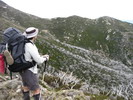
- Brinkley Bluff, June 2013
- IMG_0887a.jpg (106.47 KiB) Viewed 33638 times
-
dplanet - Phyllocladus aspleniifolius
- Posts: 580
- Joined: Thu 04 Oct, 2007 8:21 pm
- Location: Ormond-Caulfield, Melbourne
- Region: Victoria
- Gender: Female
Re: Larapinta Trail - Aug2013
![]() by forest » Mon 12 Aug, 2013 7:50 am
by forest » Mon 12 Aug, 2013 7:50 am
bernieq wrote:I can’t agree more, John, that light shoes/runners just don’t cut the mustard on the Larapinta.chapman wrote:Parks have had to do a few rescues recently of walkers with heavily bruised feet - so bad they could not walk. All were wearing runners - the ground is very rocky and many rocks are also very sharp
The relentless fractured quartzite is very tough on feet and ankles. Of significant benefit is stiffening (ie a shank) under your foot to limit flex - standard in full-leather boots but not common in runners.
Good that you had great weather. We too, in 2010, had heavy rain at Rock Bar Gap (overnight). Flooding in the Davenport and Finke rivers forced a detour but allowed us to camp beside running water for most of the rest of the trip - magic !
Wow rescues from trail runners. I was out there in June wearing Inov-8 295's which are quite minimal, no stiffness at all in the sole. I'd have to say if I did it again I'd wear my runners, I don't say that stupidly / stubornly. I didn't have an issue. Kicked a few decent rocks (Hard early in the trip) and I still have some black toe nails but I've had that in boots too.
As for bruised feet from light shoes I would have to say yes it would be possible, to the uninitiated runner wearer with a big pack. I've written this again and again. Runners are the poo if you can condition your feet and ankles, and a pack over about 12-15kgs is asking for trouble with minimal support.
I have 3 years now for 90% of my walking in light trail runners. Larapinta was a non issue for my feet but it is a very, very, very rocky track
I like the flex of my runners, they are super grippy on the rocks and I didn't slip once out there. Saying they just don't cut the mustard is a comment I'll not agree on. There were plenty of people out there wearing runners, some experienced that didn't worry me, Some looking very ginger in there light choice of shoe.
I'm still working on my trip report, it's kind of a novel and I'm trying to trim it down. Once it's finished I'll post it up for all to read.
I am a GEAR JUNKIE and GRAM COUNTER !!
There, It's out. I said it, Ahh I feel better now :lol:
There, It's out. I said it, Ahh I feel better now :lol:
-
forest - Phyllocladus aspleniifolius
- Posts: 892
- Joined: Wed 13 Jul, 2011 9:21 am
- Location: Hunter Valley
- Region: New South Wales
- Gender: Male
Re: Larapinta Trail - Aug2013
![]() by GPSGuided » Mon 12 Aug, 2013 8:56 am
by GPSGuided » Mon 12 Aug, 2013 8:56 am
Isn't it a question of what one is used to? Aboriginals probably have walked the area for thousands of years barefoot while some adapted outsiders can cope with minimal protection. For the vast majority of city dwellers who attempt these rocky paths, their/our need for stiff soles for protection is understandable.
Just move it!
-

GPSGuided - Lagarostrobos franklinii

- Posts: 6968
- Joined: Mon 13 May, 2013 2:37 pm
- Location: Sydney
- Region: New South Wales
Re: Larapinta Trail - Aug2013
![]() by photohiker » Mon 12 Aug, 2013 10:22 am
by photohiker » Mon 12 Aug, 2013 10:22 am
I've seen enough people in pain in their boots to understand that it is never as simple as deeming the 'right' footwear for other walkers.
It's no good having sturdy boots if they tear your feet apart - the object is for the walker and their footwear to arrive at the destination. I agree that flimsy footwear is probably not a good idea for the Larapinta, but then there are plenty of well made, non-flimsy but lightweight alternatives to hard boots.
The trick for me is to have adequately worn in footwear and relevant training for the conditions on the trail.
Michael
-

photohiker - Lagarostrobos franklinii
- Posts: 3130
- Joined: Sun 17 May, 2009 12:31 pm
- Location: Adelaide, dreaming up where to go next.
Re: Larapinta Trail - Aug2013
![]() by MVino » Mon 12 Aug, 2013 6:24 pm
by MVino » Mon 12 Aug, 2013 6:24 pm
I don't know if you have already left, but I am planning on starting on my own around the 20th of August..
- MVino
- Nothofagus cunninghamii
- Posts: 1
- Joined: Mon 12 Aug, 2013 6:19 pm
- Region: Australia
- Gender: Female
Re: Larapinta Trail - Aug2013
![]() by dplanet » Thu 15 Aug, 2013 12:49 pm
by dplanet » Thu 15 Aug, 2013 12:49 pm
serious? I started the trip from mid June. It may be warm in late August and i would suggest you check out BOM site. Any questions?
-
dplanet - Phyllocladus aspleniifolius
- Posts: 580
- Joined: Thu 04 Oct, 2007 8:21 pm
- Location: Ormond-Caulfield, Melbourne
- Region: Victoria
- Gender: Female
Re: Larapinta Trail - Aug2013
![]() by dplanet » Mon 19 Aug, 2013 8:56 pm
by dplanet » Mon 19 Aug, 2013 8:56 pm
dplanet wrote:Just did it from Redbank Gorge to Standley Chasm, so I can let you know:
(1) that there are bins at Ormiston Gorge and Standley Chasm, but not at Ellery Creek. As bernieq mentioned, you can leave (clean) rubbish in the food containers provided by charter transport & food drops operator,
(2) Have maps, a compass, and a gps (optional). Start early and take your time (look up, look around and use your common sense), you will be fine. I lost the trail few times because of trying to get to high points for views and lookouts.
(3) Tanks water was fine. Drank untreated water without a problem. Carried tablets with me, but did not use.
The following is an over view of my first few days.
Day One:
Fly from Melbourne to Alice Springs on Tiger Airways, and stay at YHA Alice Springs for two nights. Visit to Tourism Central Australia Visitor Centre on Gregory Terrace for info on food-drop key and to the Lone Dingo bushwalking store. These are located just minutes from YHA.
Day Two:
Buy gas & food for lunch meals such as wraps, crackers, peanut butter, cream cheese, and vegemite. Supermarkets are also very close to YHA. Pick up the food-drop key from The Tourism Office with the deposit of $50, then take a walk along Todd River in the afternoon.
Day Three:
Leave Alice Springs on a charter transport to Redbank Gorge at 2.30pm (not 2.00pm as booked. The transfer operator are late) with 3 food drops to be placed at Stanley Chasm, Ellery Creek and Ormiston Gorge.
Share transport with Mullet (Bairnsdale, Vic), Forest (H.Valley, NSW), Bellie (Brisbane, Qld), and Phil & Joyce (contacts via this bushwalk forum, see share transport sect). We have fun with a rock wallaby by the roadside near the carpark, arrive in late afternoon and set up tents at the walk-in campsite at Redbank Creek just before it gets dark.
Day Four:
Day trip to Mt Sonder and back (Section 12 - Grade: medium, 15.8km) then a side trip to Redbank Gorge and the lookout in the afternoon.
If my memory serves me correctly, I am awoken at 2.30am by a noisy guided group of walkers, who probably stayed in the car camping area on the hill and are heading for the Mt Sonder summit at dawn. A bit later, I also hear others in our group leaving. I also get up early, but end up leaving at around 7.00am. My misplaced fit-over glasses are holding me up a bit. I am quite sure that I am the last to leave.
About half of the way up, I meet those from our group and the guided group, who are on the way back down. Near the summit, I meet Don Fry (and his colleague?), Superintendent, Central Desert Division, Southern Command, NT Police, who is very friendly and helpful and offers his sun-glasses, which I politely refuse. Later, we meet again and this time i can not say no to his mandarin ( in fact, two are offered).
I enjoy lunch on the summit of Mt Sonder with 360º views of Mt Zeil, the highest in The NT 1531m in the northwest, Mt Razorback 1274m and Redbank Hill 1111m in the west, Ormiston Pound and Mt Giles 1389m in the east. Here, with Telstra service, i can send a text message and receive a phone call with the weather forecast for the next few days. A couple arrive a bit later and so there is a photo opportunity. We take turn for a pose. I am the last to leave the summit with some stops at the lookouts on the way down and see a dingo wandering around the campsite, at which there is only my tent left. The others continue on.
After a quick afternoon tea, I set off again and this time to make a visit to Redbank Gorge, then climb up The Lookout near the car park, where I meet two female walkers, who complete their walk which was started from Standley Chasm about 12 days ago. It looks like that they are using the shelter for the night (hanging around for a transfer or a lift back to Alice Springs?).
I am still working on the entire trip report, which will be made available ...
- Attachments
-
- Larapinta Trail
-
- Redbank Creek campsite, where a dingo is spotted wandering in late afternoon.
- LT_rb_1.jpg (234.39 KiB) Viewed 33298 times
-
- Redbank Hill from my tent
- LT_rb_2.jpg (228.45 KiB) Viewed 33298 times
-
- Track to Mt Sonder
- LT_MtS_1.jpg (162.72 KiB) Viewed 33298 times
-
- The rocky ridge to Mt Sonder Lookout
- LT_Mts_2.jpg (212.09 KiB) Viewed 33298 times
-
dplanet - Phyllocladus aspleniifolius
- Posts: 580
- Joined: Thu 04 Oct, 2007 8:21 pm
- Location: Ormond-Caulfield, Melbourne
- Region: Victoria
- Gender: Female
Re: Larapinta Trail - Aug2013
![]() by Eremophila » Mon 19 Aug, 2013 10:22 pm
by Eremophila » Mon 19 Aug, 2013 10:22 pm
Great pix D, makes me homesick 
I've seen members of the local bushwalking club from Alice Springs, happily doing 30km day walks on the Larapinta Trail in Dunlop Volleys.....
I've seen members of the local bushwalking club from Alice Springs, happily doing 30km day walks on the Larapinta Trail in Dunlop Volleys.....
-
Eremophila - Phyllocladus aspleniifolius
- Posts: 936
- Joined: Mon 24 Oct, 2011 5:15 pm
- Location: SW Vic
- Region: Victoria
- Gender: Female
Re: Larapinta Trail - Aug2013
![]() by dplanet » Wed 21 Aug, 2013 10:34 pm
by dplanet » Wed 21 Aug, 2013 10:34 pm
dplanet wrote:dplanet wrote:Just did it from Redbank Gorge to Standley Chasm, so I can let you know:
Day One on the Larapinta Trail:
Day trip to Mt Sonder and back (Section 12 - Grade: medium, 15.8km) then a side trip to Redbank Gorge and the lookout in the afternoon.
If my memory serves me correctly, I am awoken at 2.30am by a noisy guided group of walkers, who probably stayed in the car camping area on the hill and are heading for the Mt Sonder summit at dawn. A bit later, I also hear others in our group leaving. I also get up early, but end up leaving at around 7.00am. My misplaced fit-over glasses are holding me up a bit. I am quite sure that I am the last to leave.
About half of the way up, I meet those from our group and the guided group, who are on the way back down. Near the summit, I meet Don Fry (and his colleague?), Superintendent, Central Desert Division, Southern Command, NT Police, who is very friendly and helpful and offers his sun-glasses, which I politely refuse. Later, we meet again and this time i can not say no to his mandarin ( in fact, two are offered).
I enjoy lunch on the summit of Mt Sonder with 360º views of Mt Zeil, the highest in The NT 1531m in the northwest, Mt Razorback 1274m and Redbank Hill 1111m in the west, Ormiston Pound and Mt Giles 1389m in the east. Here, with Telstra service, i can send a text message and receive a phone call with the weather forecast for the next few days. A couple arrive a bit later and so there is a photo opportunity. We take turn for a pose. I am the last to leave the summit with some stops at the lookouts on the way down and see a dingo wandering around the campsite, at which there is only my tent left. The others continue on.
After a quick afternoon tea, I set off again and this time to make a visit to Redbank Gorge, then climb up The Lookout near the car park, where I meet two female walkers, who complete their walk which was started from Standley Chasm about 12 days ago. It looks like that they are using the shelter for the night (hanging around for a transfer or a lift back to Alice Springs?).
.
Day Two:
Walking from Redbank Gorge to Rocky Bar Hilltop tentsite, which is just 5 minutes to the official campsite, 1010m (Section 11). Will try to make it on my next revisit planned in an opposite direction.
Luckily, the glasses are accidentally found in low scrub near the tent while packing in the morning on the day leaving for the second day on The Larapinta Trail. At the junction, I bump into a guided group of about 6 walkers and have a chat to one of them, who then passes me onto the guide, who hesitates to answer my questions. Perhaps, he has a conflict of interest.
The walk to Rocky Bar Gap is easy and nice with a view of Mt Sonder along the way. There is evidence of recent fire in some parts of the area. I have a stop for lunch, go past the conical hill in the Mereenie Valley and arrive at Rocky Bar Gap campsite early afternoon. A new hydro loo with a view can be spotted here. It is too early to camp, so I collect water from the tank for cooking dinner, breakfast, and drinking until the next water point at Finke River, then move on with the aim of camping at Hilltop Lookout for the night. The climb up Hilltop is rather tiring and it is getting dark. On reaching a saddle, which can accomodate one or two tents, I decide to call it the day. Early bed, early rise for views. During the night while out for "a call of nature" I make a mistake. I can not find my way back even though I am only a couple of metres away from the tent and in my undies. The whole area is in darkness and my tent is also dark. It takes about 10 minutes to find it and I feel great to be in the down sleeping bag again. Will have a back-up light on my future solo trips.
- Attachments
-
- View of Mt Sonder from Larapinta Trail in mulga forest
- LTs11a.jpg (202.46 KiB) Viewed 33216 times
-
- Rocky Bar Gap
- LTs11b.jpg (214.87 KiB) Viewed 33216 times
-
- Mt Sonder from Mereenie Valley
- LTs11c.jpg (162.54 KiB) Viewed 33216 times
-
- Sunrise views of Mt Sonder from Hilltop
- LTs11dddd.jpg (138.96 KiB) Viewed 33216 times
-
- LTs11ddd.jpg (152.26 KiB) Viewed 33216 times
-
dplanet - Phyllocladus aspleniifolius
- Posts: 580
- Joined: Thu 04 Oct, 2007 8:21 pm
- Location: Ormond-Caulfield, Melbourne
- Region: Victoria
- Gender: Female
Re: Larapinta Trail - Aug2013
![]() by dplanet » Fri 30 Aug, 2013 10:23 pm
by dplanet » Fri 30 Aug, 2013 10:23 pm
Day Three:
I wake up before dawn, but stay warm in the sleeping bag, and get out at the first light from the sun reflecting on the tent. It is an amazing experience to see the change in the colours of the sunrise over Mt Sonder and the surrounding countryside. It is absolutely fantastic. The above photographs tell it all.
After having breakfast with oats and honey and a cup of tea, I do the packing, then shoulder my pack to start the day aiming at Hilltop Lookout or Ormiston Gorge for the night. Hilltop Lookout is the second hilltop lookout on the LT - West to East - Section 10.
It takes only several minutes to reach the Rocky Bar Hilltop Lookout campsite, which looks rather exposed. It is pity that I could not make it to the top yesterday because I didn't want to pitch the tent in the dark. Putting the pack down against a signpost, I wander around checking a few tent sites on the hard ground. Leaving the lookout tent sites, I walk east along the crest of the ridge for a couple hundred metres, then follow a steep zig-zagging track, south-east, down Davenport Creek in the Mereenie Valley. There is a small water hole in the wide and dry creek bed, but I do not recommend it for drinking. Campsites can be found on the bank of this sandy creek.
Continuing on, I cross the creek, follow the trail south-east for about 2km and reach a 4WD track, which is used only for emergencies. From here, an easy 1.5km walk south then southeast takes me to Glen Helen Junction and a further 0.5km east to the Frinke River campsite shelter, which includes: a large sleeping flatform, a table, a water tank, a loo, an info board with a logbook, and a bbq hotplate. While having a rest with some sweets and a cuppa, I hear a motor bike roaring about 100m away. Probably, it is on the Two Mile vehicle track, which leads from/to a 4WD camping area, which is about 2km SSW. After filling out my intended route for the next day in the log book and topping up the two water containers of 1 & 5 litres, I retrace my steps to the Larapinta Trail junction and turn right, heading east along the wide track for several hundred metres until the soft sand-filled Ormiston Creek is reached.
The crossing is rather wide, so be careful looking for the trail marker on the tree. From here, it is an easy 2.5km to the ridge with the Hilltop Lookout at 720m height, which provides good views of Heavitree Range to the northeast, Ormiston Gorge to the east and Mt Sonder to the west. There is the possibility of using one tent site on the crest of the ridge and it is cloudy in the late afternoon, so I am unsure whether to move on to Ormiston Gorge, which is about 3.5km away. I have a quick look at notes and maps of John & Monica Chapman and NT Parks & Wildlife. I think of the things, which will be needed to be done at Ormiston Gorge tomorrow such as the collection of the first food drop, Ormiston Pound - Ghost Gum loop (about 31/2 hours walk), hot showers and the washing. I decide to spend the night here. It is rather windy while I am pitching the tent and it is also exposed up here, so the rocks around are put to good use. The sun is in the clouds, so this evening's sunset is uninteresting.
Day Four:
Walk from Ormiston Lookout to Ormiston Gorge Campsite, pick-up food drop, do Ormiston Pound loop, have hot showers and do the washing
Unlike the impressive sunrise over Mt Sonder yesterday, this morning's sunrise over the Heavitree Range in the east is less impressive. The day starts with a short walk down a small saddle, where there is the possibility to setup 1 or 2 tents. It is less exposed to camp here than on the top. The trail continues north, zig-zagging for some hundred metres down the valley, where I meet a couple, who are walking in the opposite direction. They have been on the trail for 2 weeks, but look so clean. Through conversation with them, I learn of 1 or 2 nice camping spots and the possibility of hot showers at Ormiston Gorge campground. They also let me know that the caretaker has gone to town and she will be back later in the day. From here, the trail goes mostly down: west about 200m, north some hundred metres and then east about 2km to reach a large sandy creek. It is quite enjoyable walk among low hills and across dry creeks and there are good views of Heavitree Range. At the creek junction, I walk up a gully, head east about 1km over a ridge, then descend into a mallee forest passing an old fence and arriving at a one-way vehicle track. The Larapinta Trail walker's campsite is located just to the left. Most of tent sites are sheltered and hard and I am the first LT walker to arrive, so I am able to pick and choose a soft tent site with 1 or 2 rocks for seats. It is before noon, when the tent is up. I then wander to the food drop storage room, which is next to the toilet block located in the car park. I go past a large picnic area, the two shower rooms, and the large dome to be used mainly for displays, meetings, education, and entertainment, etc.
After sorting out the food drop bag and a quick lunch, I am off for the Ghost Gum and Ormiston Pound circuit, which takes about 3 hours to cover the distance of 11.1 km (ref. my gpx route). The Ghost Gum walk starts near the track information shelter, which is located near the visitor information centre and opposite to the toilet block. There is a track signpost with a red & white track marker, which is in contrast to the Larapinta Trail markers in blue and white (see the LT trail map from previous post).
The Ghost Gum walk starts easily and then becomes a gentle zig-zagging climb up a well-constructed lookout platform at 735m height, which provides some great views of Ormiston Gorge to the west and Ormiston Pound to the east. The track continues east down for 1.1km to meet the junction of the Ghost Gum and Ormiston Pound tracks on the river bank. Ormiston Gorge is huge and it is so beautiful, so I spend a bit of time to take it all in and I spot a dingo wandering along the south side. Likely, it is heading to the campground.
A bit of care is needed here to get around a cliff face to get down to the dry part of the river bed on the other side, then to follow the river bed upstream to go through the rough gorge, with opportunities of rock scrambling and hopping, where I meet few day trippers, who are walking in the opposite direction and had started from the car park about 2 hours ago. On leaving the gorge at Ormiston Creek, I follow the creek upstream, north-east, about 200m then swing south-east, about 1.6km. At the second crossing of Ormiston Creek, I spot a trail marker on the tree. Following the trail marker I arrive at the floor of Ormiston Pound. The track then climbs south-east and gently swings south-west up a lookout at 760m. From here, the walk to Ormiston campground is very straight forward. It involves a gentle 2km walk along the crest of a ridge down onto the road, the Larapinta Trail junction signpost, where I keep to the right, following the road for 700m to arrive at the campground and try to locate the residence of Park's Ranger for the access key to hot showers.
After showers, I head to the public toilet block for the washing. When back to my tent, I realize that I am not alone. There are 2 more tents at the campsite and there is a group of 4 walkers, whose plan is also like mine, heading for Waterfall Gorge tomorrow.
I am off to bed at 8.00pm after the arrangement of camping fee, which is $10.00 per person per night.
- Attachments
-
- Mt Sonder from Ormiston Lookout, 705m
- LT_s10e.jpg (151.74 KiB) Viewed 32945 times
-
- Ormiston Lookout with Heavitree Range and Ormiston Gorge in the background
- LT_s10f.jpg (160.14 KiB) Viewed 32945 times
-
- Ormiston Gorge and Ormiston Pound
- LT_s10a.jpg (210.68 KiB) Viewed 32945 times
-
- LT_s10b.jpg (189.71 KiB) Viewed 32945 times
-
- The floor of Ormiston Pound
- LT_s10g.jpg (156.28 KiB) Viewed 32945 times
-
dplanet - Phyllocladus aspleniifolius
- Posts: 580
- Joined: Thu 04 Oct, 2007 8:21 pm
- Location: Ormond-Caulfield, Melbourne
- Region: Victoria
- Gender: Female
Re: Larapinta Trail - Aug2013
![]() by MountainFish » Sat 31 Aug, 2013 1:15 am
by MountainFish » Sat 31 Aug, 2013 1:15 am
Watching these trip reports with keen interest, heading out that way myself next week  Planning to follow John Chapman's itinerary. You write well and have useful details!
- MountainFish
- Nothofagus cunninghamii
- Posts: 4
- Joined: Fri 23 Aug, 2013 3:45 pm
- Region: New South Wales
- Gender: Male
Re: Larapinta Trail - Aug2013
![]() by dplanet » Sun 01 Sep, 2013 1:17 am
by dplanet » Sun 01 Sep, 2013 1:17 am
If having time and enjoying carrying water, the tent sites along the trail I recommend are:
Rocky Bar Lookout, 1010m (as mentioned in John Chapman’s Web site and Guide book)
Giles Lookout, 1088m. You need to go further involving a climb from Base of Hill and then a pleasant walk along rocky Heavitree Range.
Pioneer Creek is also nice with views of Heavitree Range at dawn and dusk
Counts Point. There is one or two tent sites at the lookout.
After Counts Points, a side trip to Serpentine Gorge and The Lookout should not be missed.
Huge Gorge Junction soft sand camping. It is worth to do a side trip to upper gorge.
Razorback high camp. It is rather exposed, but doable
Brinkley Bluff as seen from previous post
Hope weather will be kind for your walking and camping.
- Attachments
-
- Rocky Bar Lookout in JC's Guide book, p147
- f1.jpg (192.4 KiB) Viewed 32860 times
-
- Giles Lookout
- f2.jpg (168.92 KiB) Viewed 32860 times
-
- Heavitree Range at dusk
- f3.jpg (78.68 KiB) Viewed 32860 times
-
- Counts Point Lookout
- f4.jpg (191.98 KiB) Viewed 32860 times
-
- Razorback Ridge
- f5.jpg (193.39 KiB) Viewed 32860 times
-
dplanet - Phyllocladus aspleniifolius
- Posts: 580
- Joined: Thu 04 Oct, 2007 8:21 pm
- Location: Ormond-Caulfield, Melbourne
- Region: Victoria
- Gender: Female
Re: Larapinta Trail - Aug2013
![]() by north-north-west » Sun 03 Nov, 2013 1:32 pm
by north-north-west » Sun 03 Nov, 2013 1:32 pm
bernieq wrote:I can’t agree more, John, that light shoes/runners just don’t cut the mustard on the Larapinta.chapman wrote:Parks have had to do a few rescues recently of walkers with heavily bruised feet - so bad they could not walk. All were wearing runners - the ground is very rocky and many rocks are also very sharp
It's all in how you walk. I wore Merrell Moabs (fairly sturdy walking shoes) without gaiters, and shorts. And did quite a bit of off-track exploration. No probs apart from the spinifex. Gaiters would have been good, but too hot.
"Mit der Dummheit kämpfen Götter selbst vergebens."
-

north-north-west - Lagarostrobos franklinii
- Posts: 15123
- Joined: Thu 14 May, 2009 7:36 pm
- Location: The Asylum
- ASSOCIATED ORGANISATIONS: Social Misfits Anonymous
- Region: Tasmania
Re: Larapinta Trail - Aug2013
![]() by chapman » Thu 13 Feb, 2014 8:40 pm
by chapman » Thu 13 Feb, 2014 8:40 pm
Regarding footwear, if you already know what works for you then you dont need any advice. For those who have little idea, they probably have softer soled feet and are not used to multi-day walking with a full pack. The advice I give to those walkers for the larapinta trail is go for a lightweight boot with some sort of shank, which means the sole has some stiffness in it. The real problem has been people using cheap runners with zero support who also have zero experience.
I hope that makes it clearer for all, if you already know what works for you then you dont need advice. However just suggesting that those with little experience simply follow what you find works for you can be very frustrating for others. In many places I use lighter weight or less equipment than what is recommended for inexperienced walkers. I know exactly what I can get away with safely but for those with no experience to send them in with my gear could be downright dangerous. An example is I walk everywhere in shorts and even ski in shorts. I am sure there are many in this newsgroup who would agree that I should not recommend that everybody else should ski and snow camp with shorts just because I do. I do carry waterproof overpants for when its really extreme but rarely use them.
regards to all
John Chapman
- chapman
- Nothofagus gunnii
- Posts: 30
- Joined: Wed 18 Apr, 2007 10:37 am
- Location: Melbourne
Re: Larapinta Trail - Aug2013
![]() by Walking_addict » Sun 16 Feb, 2014 1:28 pm
by Walking_addict » Sun 16 Feb, 2014 1:28 pm
dplanet wrote:
Counts Point, I wonder if we stood in almost the exact same place to take that pic
..
Cheers,
Les
Les
-

Walking_addict - Atherosperma moschatum

- Posts: 84
- Joined: Sun 22 Dec, 2013 10:12 pm
- Location: Adelaide, South Australia
- Region: South Australia
- Gender: Male
Re: Larapinta Trail - Aug2013
![]() by north-north-west » Sun 16 Feb, 2014 3:26 pm
by north-north-west » Sun 16 Feb, 2014 3:26 pm
I think taking a photo from that point is mandatory.
"Mit der Dummheit kämpfen Götter selbst vergebens."
-
north-north-west - Lagarostrobos franklinii
- Posts: 15123
- Joined: Thu 14 May, 2009 7:36 pm
- Location: The Asylum
- ASSOCIATED ORGANISATIONS: Social Misfits Anonymous
- Region: Tasmania
Re: Larapinta Trail - Aug2013
![]() by Senji_Man » Tue 07 Oct, 2014 5:53 pm
by Senji_Man » Tue 07 Oct, 2014 5:53 pm
Any suggestions on finding transport (at a reasonable cost) out to Redbank Gorge with food drops along the way. Will consider hitching at as a last resort.
Recent trips: Never Never Circuit, Turrana Circuit, Mt Field West, Overland Track (South to North), Mt Albert
-
Senji_Man - Nothofagus gunnii
- Posts: 32
- Joined: Fri 29 Mar, 2013 9:32 am
- Location: George Town
- Region: Tasmania
- Gender: Male
Re: Larapinta Trail - Aug2013
![]() by chapman » Tue 07 Oct, 2014 7:28 pm
by chapman » Tue 07 Oct, 2014 7:28 pm
The ideal is to join with a group who have already booked transport. You can try all the transport providers for that. Leave it until a few weeks before you go as most bookings will be completed by then.
Another possibility is to contact World Expeditions.they now advertise Larapinta Transfers on their website. If your dates fit with their trips then you might be able to get a lift with the guides and put your drops in that way. It wont be free but should be cheaper than a special charter. The guides often have to run back to Alice Springs for fresh food and also move gear from place to place. On our trip last year the company we booked with had a clash and they arranged for WE guides to take us out to redbank - the guides were going out with fresh food to Rocky Bar which is just a few km short of redbank. Our food drops were put in later - the companies are reliable at puting them in and it all goes into a locked room - make sure you get a key and also label your box well. Last year there were around 100 boxes in each room, some full and some empty and stacked very high. At Ellery Creek it took 20 minutes to find ours, next time it will have a bright distinctive sticker so we can spot it easily instead of just some black writing.
Hitching, possible but most vehicles are full but then you never know your luck, you only need 1 space. I would allow 2 or 3 days to hitch as its very unlikely any tourist would drive direct to redbank - they will almost certainly stop at most of the sights along the way.
Hope that helps.
John
- chapman
- Nothofagus gunnii
- Posts: 30
- Joined: Wed 18 Apr, 2007 10:37 am
- Location: Melbourne
Re: Larapinta Trail - Aug2013
![]() by north-north-west » Wed 08 Oct, 2014 9:26 am
by north-north-west » Wed 08 Oct, 2014 9:26 am
I can't really comment on the difficulty of hitching a ride out to Redbank.
But if you walk the track in the direction it's meant to be done - east to west - it's easy enough to catch a ride from Redbank back into the Alice. Even easier if you get yourself out to the main road.
But if you walk the track in the direction it's meant to be done - east to west - it's easy enough to catch a ride from Redbank back into the Alice. Even easier if you get yourself out to the main road.
"Mit der Dummheit kämpfen Götter selbst vergebens."
-
north-north-west - Lagarostrobos franklinii
- Posts: 15123
- Joined: Thu 14 May, 2009 7:36 pm
- Location: The Asylum
- ASSOCIATED ORGANISATIONS: Social Misfits Anonymous
- Region: Tasmania
27 posts
• Page 1 of 1
Return to South Australia, Western Australia & Northern Territory
Who is online
Users browsing this forum: No registered users and 24 guests