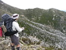
I did a circuit of Howitt Plains-Spec-Viking-Zeka in March. Here is my belated blog post of the trip.
http://trailsandtracks.blogspot.com.au/ ... iking.html
Edit: Removed the mobile link - now the blog will display properly!
Wonnangatta Circuit trip report
Forum rules
Posting large/multiple images in this forum is OK. Please start topic titles with the name of the location or track.
For topics focussed on photos rather than the trip, please consider posting in the 'Gallery' forum instead.
This forum is for posting information about trips you have done, not for requesting information about a track or area.
23 posts
• Page 1 of 1
Wonnangatta Circuit trip report
![]() by andrewbish » Mon 02 Dec, 2013 5:36 am
by andrewbish » Mon 02 Dec, 2013 5:36 am
Last edited by andrewbish on Mon 02 Dec, 2013 1:28 pm, edited 1 time in total.
Twitter: @andrewbishxplor Blog: Trails & tracks
-
andrewbish - Phyllocladus aspleniifolius

- Posts: 802
- Joined: Mon 03 Jan, 2011 7:08 pm
- Location: Melbourne
- Region: Victoria
- Gender: Male
Re: Wonnangatta Circuit trip report
![]() by Travis22 » Mon 02 Dec, 2013 7:28 am
by Travis22 » Mon 02 Dec, 2013 7:28 am
Fantastic report Andrew.
Bugger re: the wrong turn at Licola! Sorry but I did laugh out loud reading that part of your report. (I thought u were semi regular visitor to that area)
At least you were in a lovely part of the high country and it's quite nice going the back way to Primrose Gap passed old Ralph's Landy collection and portable 'house'.
Travis
-

Travis22 - Phyllocladus aspleniifolius
- Posts: 704
- Joined: Thu 15 Nov, 2012 7:11 pm
- Region: Victoria
- Gender: Male
Re: Wonnangatta Circuit trip report
![]() by andrewbish » Mon 02 Dec, 2013 8:41 am
by andrewbish » Mon 02 Dec, 2013 8:41 am
Thanks, Travis. I like to disclose all in my posts, including the stuff ups, in the interests of saving others from repeating my occasional brain-fades.
For the record, I have been Howitt, Spec, etc a few times, but always via Mansfield. I'd never been to Mac Springs before this trip. I think that only makes me a level 1 dumb-ass.
For the record, I have been Howitt, Spec, etc a few times, but always via Mansfield. I'd never been to Mac Springs before this trip. I think that only makes me a level 1 dumb-ass.
Twitter: @andrewbishxplor Blog: Trails & tracks
-
andrewbish - Phyllocladus aspleniifolius
- Posts: 802
- Joined: Mon 03 Jan, 2011 7:08 pm
- Location: Melbourne
- Region: Victoria
- Gender: Male
Re: Wonnangatta Circuit trip report
![]() by sim1oz » Mon 02 Dec, 2013 10:30 am
by sim1oz » Mon 02 Dec, 2013 10:30 am
Great report, Andrew. That walk is on my list so your trip report, with all the details and photos, is very handy. We'll pay special attention to our driving once we pass Licola It's pretty impressive that you effectively managed to fit it into two and a bit days!
Carpe diem!
-

sim1oz - Athrotaxis cupressoides

- Posts: 479
- Joined: Mon 17 Jan, 2011 10:15 pm
- Region: Victoria
- Gender: Female
Re: Wonnangatta Circuit trip report
![]() by Avatar » Mon 02 Dec, 2013 12:58 pm
by Avatar » Mon 02 Dec, 2013 12:58 pm
Nice report Andrew.
Here's another too: http://www.hikingfiasco.com/
I'd like to do this circuit too - but about half your pace!
Can you tell your readers of the water sources you used?
Here's another too: http://www.hikingfiasco.com/
I'd like to do this circuit too - but about half your pace!
Can you tell your readers of the water sources you used?
-
Avatar - Athrotaxis cupressoides
- Posts: 279
- Joined: Sun 07 Jul, 2013 5:21 pm
- Location: NE Melbourne
- Region: Victoria
Re: Wonnangatta Circuit trip report
![]() by andrewbish » Mon 02 Dec, 2013 1:56 pm
by andrewbish » Mon 02 Dec, 2013 1:56 pm
Avatar wrote:Can you tell your readers of the water sources you used?
Sure.
I started with 4.5 lt. In my haste I decided to ignore possible refill spots at Mt Spec and Viking Saddle. I ran out on the spur down to the Wonnangatta River, with about 4 hours walking before I could refill at the river.
Twitter: @andrewbishxplor Blog: Trails & tracks
-
andrewbish - Phyllocladus aspleniifolius
- Posts: 802
- Joined: Mon 03 Jan, 2011 7:08 pm
- Location: Melbourne
- Region: Victoria
- Gender: Male
Re: Wonnangatta Circuit trip report
![]() by north-north-west » Mon 02 Dec, 2013 3:52 pm
by north-north-west » Mon 02 Dec, 2013 3:52 pm
I was delighted to find a fire blazing away in a simple, stone ring fireplace and a couple of guys sitting around it, enjoying the heat.
You shouldn't have been. That's a Fuel Stove Only area and I'm sick to death of finding new fire scars all over it.
"Mit der Dummheit kämpfen Götter selbst vergebens."
-

north-north-west - Lagarostrobos franklinii

- Posts: 15121
- Joined: Thu 14 May, 2009 7:36 pm
- Location: The Asylum
- ASSOCIATED ORGANISATIONS: Social Misfits Anonymous
- Region: Tasmania
Re: Wonnangatta Circuit trip report
![]() by peregrinator » Mon 02 Dec, 2013 4:12 pm
by peregrinator » Mon 02 Dec, 2013 4:12 pm
north-north-west wrote:I was delighted to find a fire blazing away in a simple, stone ring fireplace and a couple of guys sitting around it, enjoying the heat.
You shouldn't have been. That's a Fuel Stove Only area and I'm sick to death of finding new fire scars all over it.
Quite rightly. I'm getting sick of seeing fire scars in non fuel stove areas as well. There's frequently more than one at a location.
- peregrinator
- Athrotaxis selaginoides

- Posts: 1776
- Joined: Fri 15 Apr, 2011 2:50 pm
- Region: Victoria
Re: Wonnangatta Circuit trip report
![]() by bigkev » Mon 02 Dec, 2013 6:49 pm
by bigkev » Mon 02 Dec, 2013 6:49 pm
Hi Andrew,
Great report, I've done the circuit twice, both times in three days its certainly a ball breaker!
The first time I did it I descended straight down the spur off South Viking and ended up in those blackberry's too, like you I was a little thirsty so I ended up using my pack to flatten a path through the crap.
On my second visit I paid a little more attention to my notes and found a cairn in the scrub near the bottom of the spur where the route veered to the left, this deposited me onto a flat area just before the old fire track leaves the river for the final time to climb and meet the Zeka Spur track. No blackberry's, much better.
I've looked at the spur you mention to climb back up, but until the fire regrowth thins out a bit, I'll stick with the 4wd track.
I'm looking forward to reading the rest of the Hiking Fiasco report, should make for some chuckles as he goes up and over The Viking.
Thanks for sharing your blog.
-
bigkev - Athrotaxis cupressoides
- Posts: 442
- Joined: Sat 30 Jun, 2012 6:44 pm
- Region: Victoria
- Gender: Male
Re: Wonnangatta Circuit trip report
![]() by andrewbish » Mon 02 Dec, 2013 9:45 pm
by andrewbish » Mon 02 Dec, 2013 9:45 pm
bigkev wrote:Hi Andrew,
Great report, I've done the circuit twice, both times in three days its certainly a ball breaker!
The first time I did it I descended straight down the spur off South Viking and ended up in those blackberry's too, like you I was a little thirsty so I ended up using my pack to flatten a path through the crap.
On my second visit I paid a little more attention to my notes and found a cairn in the scrub near the bottom of the spur where the route veered to the left, this deposited me onto a flat area just before the old fire track leaves the river for the final time to climb and meet the Zeka Spur track. No blackberry's, much better.
I've looked at the spur you mention to climb back up, but until the fire regrowth thins out a bit, I'll stick with the 4wd track.
I'm looking forward to reading the rest of the Hiking Fiasco report, should make for some chuckles as he goes up and over The Viking.
Thanks for sharing your blog.
G'day Kev
I did consider using my pack to clear the way through the blackberries, but using my bamboo walking pole for a bit of vigorous berry-thwacking seemed a more satisfying option given my somewhat agitated state of mind at that time.
In relation to the alternative route to Zeka Spur Track, forum member Borbs talks about it in this thread: viewtopic.php?f=37&t=8355&hilit=wonnangatta&start=30#p171735
There is also reference to the "Chapman route" in the same thread.
Agree re the recommendation of Greg's Hiking Fiasco blog. Always a good read.
Cheers
Andrew
BTW - Are you actually a large bloke or is the "big" ironic?
Twitter: @andrewbishxplor Blog: Trails & tracks
-
andrewbish - Phyllocladus aspleniifolius
- Posts: 802
- Joined: Mon 03 Jan, 2011 7:08 pm
- Location: Melbourne
- Region: Victoria
- Gender: Male
Re: Wonnangatta Circuit trip report
![]() by bigkev » Tue 03 Dec, 2013 6:51 pm
by bigkev » Tue 03 Dec, 2013 6:51 pm
Hi Andrew,
No irony unfortunately, I'm 6'3" and around 120 kg.
No irony unfortunately, I'm 6'3" and around 120 kg.
-
bigkev - Athrotaxis cupressoides
- Posts: 442
- Joined: Sat 30 Jun, 2012 6:44 pm
- Region: Victoria
- Gender: Male
Re: Wonnangatta Circuit trip report
![]() by Out_Walking » Thu 26 Dec, 2013 9:44 pm
by Out_Walking » Thu 26 Dec, 2013 9:44 pm
If anyone is having trouble sleeping one night, I've done a write-up of my Viking Circuit trip last month. Here's the link,
http://www.hikingfiasco.com/2013/11/the ... -park.html
That's my overall trip post, but each individual day has a separate link at the bottom of it.
My trip was three days with the longest day being from Catherine Saddle to the Wonnangatta. I thought that was bad enough, but Andrew has outdone me with Buggery to the Wonnangatta. I can feel pain just thinking about what he must have gone through
Only thing I'll mention is the parts I was worried about before going. Howitt Road is like a highway for 2WD cars (well, it was a month ago!) Before the trip I rang Heyfield Parks Vic office who confirmed the state of the road. No problems at all and I don't have much wheel clearance in my car.
At the time, plenty of water at Mac Springs and Catherine Saddle. Not sure about anywhere else, as they were the only places I filled up!
The little chimney up the Viking was nothing like I imagined. For some reason I was really worried about that bit, but found myself up it in about 5 seconds with pack on. That's me though and I'd imagine it would be a different story if it was wet!
Also, as Andrew said in the thread earlier, if you can find a friend to leave a car at the bottom of Zeka Spur Track, then do so. I found that last day to be a shocker. Maybe the off-track section is the go? I know if I go back I'll never go near Zeka Spur ever again, as it's now burnt into my memory.
Wonnangatta Spur was a weird one. I rarely saw the old track, but what I did see were a billion fallen trees. Not sure if I've stepped over so many fallen trees in my life? In the end I gave up looking for the old track and just headed up! I was possibly the happiest man in the southern hemisphere when I reached the Howitt track at the top.
If there's any justice for going with people who were insanely fit, then the last day was it. They were miles ahead of me and missed the turn-off onto Wonnangatta Spur, so they followed Zeka Spur Track all the way up to Howitt car park. Even though they are fit, I think it took a toll, as I've found they don't want to talk about it due to the horror they experienced
I reckon if you've got four days do it. Don't get caught up in this three day business like I did. It took a toll of me, but then again I'm the exact physical dimensions of Big Kev above. If you're built like a shaved bicycle spoke, then you'll wonder what all the fuss was about?
Finally, I do have the entire trip as a gpx file for the GPS if anyone wants it. Mind you, whilst descending to the Wonnangatta River, we walked around in circles in thick bush at 10 o'clock at night, so maybe my gpx is not for everyone
- Out_Walking
- Atherosperma moschatum

- Posts: 77
- Joined: Sun 18 Jul, 2010 9:59 pm
- Region: Victoria
- Gender: Male
Re: Wonnangatta Circuit trip report
![]() by JimS » Sun 19 Jan, 2014 11:15 am
by JimS » Sun 19 Jan, 2014 11:15 am
Andrews negative comments about the Zeka Spur Track have been echoed by many other contributors to this forum over a period of time. Yes it is a steep dusty boring way out of the Wonnangatta Valley and even the section of closed overgrown track at the top has little to recommend it especially the number of fallen trees and limited views. A much better alternative on this circuit walk when you arrive at the river is to head upstream along the overgrown 4WD drive track that crosses the river a couple of times and while heavily revegetated it has an obvious fairly clear pad along it created by the numerous sambar deer in this area. Despite the rumours of blackberry infestation our party of four did not have much difficulty with only an occasional thicket that the deer had cleared a path through (this was in March 2012). At approx. 3 km up the river you cross a small stream coming in from the south (some flat spots here for camping here if you want to). This point is directly opposite a high hill marked as 947 metres on topo maps. By heading south on the west bank of this stream a short distance you quickly pick up a steep narrow spur that climbs south-west then westerly. It is quite open, no scrub to deal with, no cliffs and becomes a rocky clearly defined route popping out next to the Devils Staircase and almost at Mac Springs hut. Some good knolls along this narrow ridge give views as you climb. Interestingly all the way up was evidence of deer traffic, I guess they also know the most direct and quickest way back up to the snow plains with no fallen trees! If you can navigate from Sth Viking to the river you should have no trouble navigating this more interesting way out of the valley and avoid the dreaded Zeka road slog.
- JimS
- Nothofagus cunninghamii

- Posts: 1
- Joined: Wed 15 Jan, 2014 10:13 pm
- Region: Victoria
- Gender: Male
Re: Wonnangatta Circuit trip report
![]() by north-north-west » Sun 19 Jan, 2014 5:01 pm
by north-north-west » Sun 19 Jan, 2014 5:01 pm
JimS wrote:Andrews negative comments about the Zeka Spur Track have been echoed by many other contributors to this forum over a period of time. Yes it is a steep dusty boring way out of the Wonnangatta Valley and even the section of closed overgrown track at the top has little to recommend it especially the number of fallen trees and limited views. A much better alternative on this circuit walk when you arrive at the river is to head upstream along the overgrown 4WD drive track that crosses the river a couple of times and while heavily revegetated it has an obvious fairly clear pad along it created by the numerous sambar deer in this area. Despite the rumours of blackberry infestation our party of four did not have much difficulty with only an occasional thicket that the deer had cleared a path through (this was in March 2012). At approx. 3 km up the river you cross a small stream coming in from the south (some flat spots here for camping here if you want to). This point is directly opposite a high hill marked as 947 metres on topo maps. By heading south on the west bank of this stream a short distance you quickly pick up a steep narrow spur that climbs south-west then westerly. It is quite open, no scrub to deal with, no cliffs and becomes a rocky clearly defined route popping out next to the Devils Staircase and almost at Mac Springs hut. Some good knolls along this narrow ridge give views as you climb. Interestingly all the way up was evidence of deer traffic, I guess they also know the most direct and quickest way back up to the snow plains with no fallen trees! If you can navigate from Sth Viking to the river you should have no trouble navigating this more interesting way out of the valley and avoid the dreaded Zeka road slog.
You almost make we wish I was back in Victoria to do it.
Almost . . .
"Mit der Dummheit kämpfen Götter selbst vergebens."
-
north-north-west - Lagarostrobos franklinii
- Posts: 15121
- Joined: Thu 14 May, 2009 7:36 pm
- Location: The Asylum
- ASSOCIATED ORGANISATIONS: Social Misfits Anonymous
- Region: Tasmania
Re: Wonnangatta Circuit trip report
![]() by bernieq » Sun 19 Jan, 2014 8:00 pm
by bernieq » Sun 19 Jan, 2014 8:00 pm
I've walked the Howitt - Viking - MacSprings loop a few times (in both directions) but have avoided Zeka Spur - using, instead, one of the two spurs further up the Wonnangatta. I'm just not keen on a road-bash.
The map below shows the loop in red (done anti-clockwise so down from Howitt side into the Wonnangatta). The track at the top is sign-posted and there were cairns marking what was a fairly obvious pad most of the way down.
The blue section is the spur we climbed up to Mac Springs when doing the loop clockwise in 3 days - no track and a tough climb to finish a 2nd long day. Note that the base of the spur is not obvious so a GPS to fix position is recommended.
There was (in 2009 and 2011) an obvious track up the Wonnangatta past the base of both spurs (with numerous river crossings) and re-growth after the 2007 fires was not an issue (but well may be now).
There is a bit of additional discussion at viewtopic.php?f=37&t=4153&p=121688&hilit=Zeka#p121688
The map below shows the loop in red (done anti-clockwise so down from Howitt side into the Wonnangatta). The track at the top is sign-posted and there were cairns marking what was a fairly obvious pad most of the way down.
- How to avoid Zeka Spur Tk
There was (in 2009 and 2011) an obvious track up the Wonnangatta past the base of both spurs (with numerous river crossings) and re-growth after the 2007 fires was not an issue (but well may be now).
There is a bit of additional discussion at viewtopic.php?f=37&t=4153&p=121688&hilit=Zeka#p121688
-
bernieq - Phyllocladus aspleniifolius
- Posts: 695
- Joined: Tue 17 Jan, 2012 3:43 pm
- Region: Victoria
Re: Wonnangatta Circuit trip report
![]() by dplanet » Sun 06 Apr, 2014 6:52 pm
by dplanet » Sun 06 Apr, 2014 6:52 pm
Just solo-completed the circuit: The Crosscut Saw – Mt Speculation – The Viking – part of Wannangatta Spur – Zeka Spur Tk. My first solo on this walk had been about 10 years ago and here are some points of view:
The drive:
It was doable in 2WD and took about half of day from Melbourne to Howitt Plains Car Park, the start and finish of the Wannangatta Circuit also known as the Viking Circuit, which is located on Howitt Road about 37 km from Arbuckle Junction and about 83 km from Licola, East of Melbourne. Note that I was a slow driver.
Water points:
The locations, where I stopped for filling up water, were: Macalister Springs and Camp Creek. I carried about 3.5 litres from Macalister Springs to Mt Buggery campsite and about 5.0 litres from Camp Creek to the Wonangatta River. I had learned the dry experience from The Crinoline walk some weeks ago.
I can’t comment on Catherine Saddle and Viking Saddle because I just went past. It was thundering and pouring down on my arrival at the Viking Saddle, where a stop for a shelter was needed to avoid the walk up the cliffs of the Viking.
A possible water source, I accidentally discovered while trying to get through the hole in the rocks to climb up the Viking, may be just metres away. It rained heavily while I was there and I could hear water flowing fast & steeply down (wonder if there is a pool). At that time, I did not bother because I had enough water for drinking & cooking, focussed on how to get myself & the full pack up & out and that it was getting late. I am very much keen to know of, exactly where the pool is and how to get to it, and this reminds me of a checkout on Google Earth.
Few rather important points on the walk:
Enjoyed the first two days traversing The Crosscut Saw, Mt Speculation, Mt Despair and a part of the AAWT in perfect weather. No issue at all.
The major difficulty I encountered is at the hole/s in the rocks (trying to climb up with the full pack). The problem included: going solo with a bulky & heavy pack, plus the rain. Note that the long strap (discussed on this thread) had been removed and my own rope was used. In my opinion, this could be easily done for a group of two or three.
I made a mistake on going down from the South Viking, where I heard and saw a Victoria Police Rescue Squad helicopter scouting the area (for walker/s in trouble?). A wrong spur was taken starting from the grid ref 55S – 04 752 E 58 907 N, where a light foot pad turns sharply southeast. I continued down about 100 m southwest. The climb back up the spur was a challenge because of the thick scrub, the regrowth of the recent bushfires.
The last bit down The Wannagatta River (same as other/s on this thread). This was pointed out in the guide book "Bushwalking in Australia" by Chapman was to ignore the faulse track/s, which veered to the right. It was getting dark and so I kept moving on, bashed down the river and ended up using my head torch to look for a site to pitch my tent, which was near the bank on the other side of the river and on a small sandy spot, which was surrounded by blackberries.
JC’s alternative route seemed reasonable. However, I could avoid a direct climb to the top of the knoll at 853m by sidling a bit below it. A hidden cairn in the scrub is at grid ref 04 76.8 E 58 87.6 N. It was a slow going due to the rough terrain and the thick scrub; therefore, the SSW or west-heading plan was abandoned. Now, I had to head east or southeast to meet up with Zeka Spur Tk. I followed a path down a gully, crossed it then climbed a little to reach a grassy plain. From here, a pleasant stroll with a few gentle ups led me to the Zeka Spur Tk. After following it up & up for a while, then bingo, I heard car/s approaching and was given a lift up Howitt Road. On the way out, in the front passenger seat, we had a chat and I was told of a rescue taken place at The South Viking the day before. A visitor from NSW was winched out. The walker felt ill and ran out of water.
Please note that the Zeka Spur Tk is very rough, steep and winding with many hairpin bends. I would suggest not to drive your car down there and then had to drive back up as suggested by one or two walkers on this thread.
To those going solo, I would recommand an extra day for just in case of bad weather and/or things gone bear-shaped.
Hope these notes will be of use.
- Attachments
-
- Macalister Springs in late March, 2014
- rs2.jpg (257.02 KiB) Viewed 22259 times
-
- The Crosscut Saw, Mt Buggery, Mt Speculation, Mt Konika and Mt Cobler
- rs1.jpg (187.72 KiB) Viewed 22259 times
-
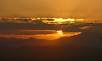
- Sunset over The Crosscut Saw from Mt Buggery campsite
- IMG_2517_rs4.jpg (157.87 KiB) Viewed 22259 times
-
- Camp Creek in late March, 2014
- rs3.jpg (265.67 KiB) Viewed 22259 times
-
- Looking east from The Viking
- rs4.jpg (54.48 KiB) Viewed 22259 times
-
dplanet - Phyllocladus aspleniifolius
- Posts: 580
- Joined: Thu 04 Oct, 2007 8:21 pm
- Location: Ormond-Caulfield, Melbourne
- Region: Victoria
- Gender: Female
Re: Wonnangatta Circuit trip report
![]() by dplanet » Mon 07 Apr, 2014 9:48 pm
by dplanet » Mon 07 Apr, 2014 9:48 pm
I was also told that there had been a few rescues in the area last month. Together with my mistake on going down from the South Viking, a map file is created
- Attachments
-
-
dplanet - Phyllocladus aspleniifolius
- Posts: 580
- Joined: Thu 04 Oct, 2007 8:21 pm
- Location: Ormond-Caulfield, Melbourne
- Region: Victoria
- Gender: Female
Re: Wonnangatta Circuit trip report
![]() by wildlight » Tue 08 Apr, 2014 4:21 am
by wildlight » Tue 08 Apr, 2014 4:21 am
Awesome post, congratulations on your effort and photos dplanet.
Cheers
WildLight.
PS There are / were two promising "permanent" water sources around the viking. One is within a gully on the cliff face, considerably to the west of the chimney, and there is a pool on the southern side not far below the summit, so well sheltered and hidden within a big clump of rocks… I need to get up there and take a look. I found these sources towards the end of a dry summer in the late 1980s.
- wildlight
- Athrotaxis cupressoides
- Posts: 215
- Joined: Tue 24 Mar, 2009 2:03 pm
Re: Wonnangatta Circuit trip report
![]() by dplanet » Tue 08 Apr, 2014 6:40 pm
by dplanet » Tue 08 Apr, 2014 6:40 pm
Thanks wildlight. Just checking out google earth, here's a pix, which shows the route up the chimey and around the viking. Go for it and I look forward to the findings.
- Attachments
-
- Q-of-W_rs.jpg (161.55 KiB) Viewed 22063 times
-
dplanet - Phyllocladus aspleniifolius
- Posts: 580
- Joined: Thu 04 Oct, 2007 8:21 pm
- Location: Ormond-Caulfield, Melbourne
- Region: Victoria
- Gender: Female
Re: Wonnangatta Circuit trip report
![]() by wildlight » Wed 09 Apr, 2014 9:23 am
by wildlight » Wed 09 Apr, 2014 9:23 am
Hey dplanet
My recollection is that the northern water source is to the west of the red line. As we walked towards the Viking from Viking Saddle, we swung west (to the right) and the instance of water occurred in a narrow cleft, well shaded and rising abruptly in front of us. So we were walking up an incline, then all of a sudden it was vertical in front of us, and very shaded- there was the water.
Keep in mind that the fires came after that- like when Mrs and I went to Hells Window the day the road was opened- the destruction of low level scrub meant the micro climate was gone- and Hellfire Creek was just gravel and dust, no chance of water. Things are different now, I believe.
As for the "Southern" area water on the Viking:
It was not very far in vertical meters, below the summit. In terms of vertical, it was about 50 meters, and linear distance perhaps 100 or 150 meters off to the southwest. It was very unexpected- A massive 5 meter high compact pile of rocks, and I went around the southern side to explore photo potential. Looking down into the base, I saw a dining-table sized owning, with a pool of water, very well shielded and in an ideal place- southerly runoff, as well as direct drainage from rocks.
It's times like this I have been glad to not be a fast walker- I see and find so much stuff. From memory the circuit took me a minimum of six days then, likely seven. Food is generally not a big planning priority, coz I carry a fifty kilo or greater "reserve" around my middle…
But I've always loaded up with water, often 7 or 8 litres in the pack in those days. My rationale was "just carry it, don't consume water and time looking for it, in what could be a wasted search".
Of course lighter gear, and a different headspace- mean a modified approach now- but we can still be found with "cautious" reserves out there, after a number of instances of dehydration, which is never pretty.
The area of the Southern pile of rocks with water pool is out of your Google photo, the picture would need to be shot from the aspect of the Wonnangatta "spur" leading down to the river, and looking back onto the Viking.
But dplanet- the rocks might be hidden by vegetation in the photo- because in the "real world", they were very sheltered by trees.
Hopefully this helps. The vegetation was quite similar to what is on the Snowy Bluff western flank, around 1300 meters, if this helps.
Cheers, WildLight
- wildlight
- Athrotaxis cupressoides
- Posts: 215
- Joined: Tue 24 Mar, 2009 2:03 pm
Re: Wonnangatta Circuit trip report
![]() by Drew » Wed 09 Apr, 2014 10:53 am
by Drew » Wed 09 Apr, 2014 10:53 am
dplanet wrote:JC’s alternative route seemed reasonable. However, I could avoid a direct climb to the top of the knoll at 853m by sidling a bit below it. A hidden cairn in the scrub is at grid ref 04 76.8 E 58 87.6 N. It was a slow going due to the rough terrain and the thick scrub; therefore, the SSW or west-heading plan was abandoned. Now, I had to head east or southeast to meet up with Zeka Spur Tk. I followed a path down a gully, crossed it then climbed a little to reach a grassy plain. From here, a pleasant stroll with a few gentle ups led me to the Zeka Spur Tk. After following it up & up for a while, then bingo, I heard car/s approaching and was given a lift up Howitt Road.
JimS wrote:Andrews negative comments about the Zeka Spur Track have been echoed by many other contributors to this forum over a period of time. Yes it is a steep dusty boring way out of the Wonnangatta Valley and even the section of closed overgrown track at the top has little to recommend it especially the number of fallen trees and limited views. A much better alternative on this circuit walk when you arrive at the river is to head upstream along the overgrown 4WD drive track that crosses the river a couple of times and while heavily revegetated it has an obvious fairly clear pad along it created by the numerous sambar deer in this area. Despite the rumours of blackberry infestation our party of four did not have much difficulty with only an occasional thicket that the deer had cleared a path through (this was in March 2012). At approx. 3 km up the river you cross a small stream coming in from the south (some flat spots here for camping here if you want to). This point is directly opposite a high hill marked as 947 metres on topo maps. By heading south on the west bank of this stream a short distance you quickly pick up a steep narrow spur that climbs south-west then westerly. It is quite open, no scrub to deal with, no cliffs and becomes a rocky clearly defined route popping out next to the Devils Staircase and almost at Mac Springs hut. Some good knolls along this narrow ridge give views as you climb. Interestingly all the way up was evidence of deer traffic, I guess they also know the most direct and quickest way back up to the snow plains with no fallen trees! If you can navigate from Sth Viking to the river you should have no trouble navigating this more interesting way out of the valley and avoid the dreaded Zeka road slog.
A group of us might be doing this walk over Easter. I did it Cup Weekend 2012 and loved it despite a bit of getting lost and the sections of hellish scrub. I'm keen to avoid the road slog on the last day so am looking at alternative routes for the climb from the river. The options seem to be John Chapman's route (or dplanet's slight variation on it) or heading upstream to about 745846 and taking the spur climbing west then south west to near Mac Springs. I guess I'd love it if anyone could tell me which option is easiest! Multiple river crossings and blackberries heading upstream makes the latter option seem less appealing. However if the river isn't too high and if the deer have maintained the track well then it could be fine. The road slog is a horrible way to end the walk, but my companions probably won't be too happy with me if I lead them on a prolonged bush bash instead!
Also, has any collected water at Viking Saddle recently? Hopefully some of the rain this week will make it up that way.
Cheers
- Drew
- Phyllocladus aspleniifolius
- Posts: 777
- Joined: Fri 13 Jan, 2012 11:16 am
- Region: Victoria
- Gender: Male
Re: Wonnangatta Circuit trip report
![]() by north-north-west » Wed 09 Apr, 2014 11:35 am
by north-north-west » Wed 09 Apr, 2014 11:35 am
wildlight wrote:My recollection is that the northern water source is to the west of the red line. As we walked towards the Viking from Viking Saddle, we swung west (to the right) and the instance of water occurred in a narrow cleft, well shaded and rising abruptly in front of us. So we were walking up an incline, then all of a sudden it was vertical in front of us, and very shaded- there was the water.
First time I was on The Viking I found that spot whilst exploring. Not a massive amount of flow, but a steady run. Looked to be a reasonably reliable source, although I'd carried enough up from Barry Saddle.
As for the "Southern" area water on the Viking:
It was not very far in vertical meters, below the summit. In terms of vertical, it was about 50 meters, and linear distance perhaps 100 or 150 meters off to the southwest. It was very unexpected- A massive 5 meter high compact pile of rocks, and I went around the southern side to explore photo potential. Looking down into the base, I saw a dining-table sized opening, with a pool of water, very well shielded and in an ideal place- southerly runoff, as well as direct drainage from rocks.
I think I know the rocks you mean, although I never went right around the southern side. But the ground below looked dampish and mossy, so the pool may well have still been there.
"Mit der Dummheit kämpfen Götter selbst vergebens."
-
north-north-west - Lagarostrobos franklinii
- Posts: 15121
- Joined: Thu 14 May, 2009 7:36 pm
- Location: The Asylum
- ASSOCIATED ORGANISATIONS: Social Misfits Anonymous
- Region: Tasmania
Re: Wonnangatta Circuit trip report
![]() by dplanet » Thu 10 Apr, 2014 12:13 am
by dplanet » Thu 10 Apr, 2014 12:13 am
Drew wrote:dplanet wrote:JC’s alternative route seemed reasonable. However, I could avoid a direct climb to the top of the knoll at 853m by sidling a bit below it. A hidden cairn in the scrub is at grid ref 04 76.8 E 58 87.6 N. It was a slow going due to the rough terrain and the thick scrub; therefore, the SSW or west-heading plan was abandoned. Now, I had to head east or southeast to meet up with Zeka Spur Tk. I followed a path down a gully, crossed it then climbed a little to reach a grassy plain. From here, a pleasant stroll with a few gentle ups led me to the Zeka Spur Tk. After following it up & up for a while, then bingo, I heard car/s approaching and was given a lift up Howitt Road.JimS wrote:Andrews negative comments about the Zeka Spur Track have been echoed by many other contributors to this forum over a period of time. Yes it is a steep dusty boring way out of the Wonnangatta Valley and even the section of closed overgrown track at the top has little to recommend it especially the number of fallen trees and limited views. A much better alternative on this circuit walk when you arrive at the river is to head upstream along the overgrown 4WD drive track that crosses the river a couple of times and while heavily revegetated it has an obvious fairly clear pad along it created by the numerous sambar deer in this area. Despite the rumours of blackberry infestation our party of four did not have much difficulty with only an occasional thicket that the deer had cleared a path through (this was in March 2012). At approx. 3 km up the river you cross a small stream coming in from the south (some flat spots here for camping here if you want to). This point is directly opposite a high hill marked as 947 metres on topo maps. By heading south on the west bank of this stream a short distance you quickly pick up a steep narrow spur that climbs south-west then westerly. It is quite open, no scrub to deal with, no cliffs and becomes a rocky clearly defined route popping out next to the Devils Staircase and almost at Mac Springs hut. Some good knolls along this narrow ridge give views as you climb. Interestingly all the way up was evidence of deer traffic, I guess they also know the most direct and quickest way back up to the snow plains with no fallen trees! If you can navigate from Sth Viking to the river you should have no trouble navigating this more interesting way out of the valley and avoid the dreaded Zeka road slog.
A group of us might be doing this walk over Easter. I did it Cup Weekend 2012 and loved it despite a bit of getting lost and the sections of hellish scrub. I'm keen to avoid the road slog on the last day so am looking at alternative routes for the climb from the river. The options seem to be John Chapman's route (or dplanet's slight variation on it) or heading upstream to about 745846 and taking the spur climbing west then south west to near Mac Springs. I guess I'd love it if anyone could tell me which option is easiest! Multiple river crossings and blackberries heading upstream makes the latter option seem less appealing. However if the river isn't too high and if the deer have maintained the track well then it could be fine. The road slog is a horrible way to end the walk, but my companions probably won't be too happy with me if I lead them on a prolonged bush bash instead!
Also, has any collected water at Viking Saddle recently? Hopefully some of the rain this week will make it up that way.
Cheers
FYI
- Attachments
-
- As discussed in my notes
- down-the-river.jpg (68.36 KiB) Viewed 21929 times
-
- WonnangattaR.jpg (206.57 KiB) Viewed 21929 times
-
dplanet - Phyllocladus aspleniifolius
- Posts: 580
- Joined: Thu 04 Oct, 2007 8:21 pm
- Location: Ormond-Caulfield, Melbourne
- Region: Victoria
- Gender: Female
23 posts
• Page 1 of 1
Return to VIC Trip Reports & Track Notes
Who is online
Users browsing this forum: Google Adsense [Bot] and 8 guests