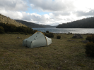
Wayno, what's your opinion on the attitude to carrying tents over there, even when hut based walking.
Is it done much? DOC site only talks about carrying survival blanket.
From the reports, it seems this group decided between crossing and hours walking in the dark back to hut.
What about pitching a tent and having a comfortable night beside the track?
tramper swept away on Milford Track
Forum rules
Please avoid publishing details of access to sensitive areas with no tracks.
Please avoid publishing details of access to sensitive areas with no tracks.
91 posts
• Page 2 of 4 • 1, 2, 3, 4
Re: tramper swept away on Milford Track
![]() by geoskid » Thu 22 May, 2014 7:47 am
by geoskid » Thu 22 May, 2014 7:47 am
Critical Thinking.. the awakening of the intellect to the study of itself.
http://www.criticalthinking.org/
http://www.criticalthinking.org/
- geoskid
- Phyllocladus aspleniifolius

- Posts: 896
- Joined: Sun 27 Apr, 2008 1:56 pm
- Region: Tasmania
- Gender: Male
Re: tramper swept away on Milford Track
![]() by wayno » Thu 22 May, 2014 8:01 am
by wayno » Thu 22 May, 2014 8:01 am
I carry a waterproof bivy bag. I consider that is sufficient for being caught out on the trips i normally do. personal choice,
i have also carried a basic tarp. or you could carry both depending on where you are travelling. how exposed it is, time of year.
bivy bag is easier to use anywhere in an emergency and usually lighter... dont have to worry about keeping it up in bad weather or being able to pitch it at all.
depends on how likely you are to need shelter. if theres a reasonable chance a swollen watercourse could cut you off for a while, i'd definitely be looking at having at least a tarp. heavy rain often comes in horizontally here you need to be prepared for that, can rain for days and you may not see the sun for weeks. and once your gear gets wet there can be little chance of it drying out after the rain stops.
its not sufficient in your trip planning to say there are huts all along the track, we don't need to carry shelter. nz weather is similar to tasmanian weather in its unpredictability and severity... (minus the heat waves).
if it rains here no amount of fancy gear may keep you dry and you need to be prepared for that... the people on this trip were likely cold and wet, their morale may have been low, their experience of river crossing inadequate, the temptation of getting to hut hut may have over ruled the decision to wait or turn back.. with backup shelter they would have had another option to wait, get their wet gear off, eat, drink, boost their morale...
you could go as far as bringing a tent, depends how much you want to cart the extra weight around,
i cant say i'm aware of people carrying tents very often as a backup... larger groups are more likely to carry one... easier to divy up the weight and other people carry other group gear to compensate..
from the land of the long white clouds...
-

wayno - Lagarostrobos franklinii

- Posts: 8784
- Joined: Sun 19 Jun, 2011 7:26 am
- Location: NZ
- Region: New Zealand
- Gender: Male
Re: tramper swept away on Milford Track
![]() by Strider » Thu 22 May, 2014 8:01 am
by Strider » Thu 22 May, 2014 8:01 am
I thought exactly the same thing Geoskid. Walking without a shelter = unprepared for potentially unforeseen circumstances in my book.
-
Strider - Lagarostrobos franklinii
- Posts: 6030
- Joined: Mon 07 Nov, 2011 6:55 pm
- Location: Point Cook
- Region: Victoria
- Gender: Male
Re: tramper swept away on Milford Track
![]() by wayno » Thu 22 May, 2014 8:12 am
by wayno » Thu 22 May, 2014 8:12 am
The partner of a tramper who died after being swept into a river in Fiordland expressed his grief yesterday at losing a loved one.
http://www.nzherald.co.nz/nz/news/artic ... d=11259439
http://www.nzherald.co.nz/nz/news/artic ... d=11259439
from the land of the long white clouds...
-
wayno - Lagarostrobos franklinii
- Posts: 8784
- Joined: Sun 19 Jun, 2011 7:26 am
- Location: NZ
- Region: New Zealand
- Gender: Male
Re: tramper swept away on Milford Track
![]() by wayno » Thu 22 May, 2014 8:23 am
by wayno » Thu 22 May, 2014 8:23 am
i'm pretty sure this photo is taken either on pompolona creek or near to it,,
if you look at the green poles on the ground, that is the bridge that has been covered up by boulders moved by flood water...
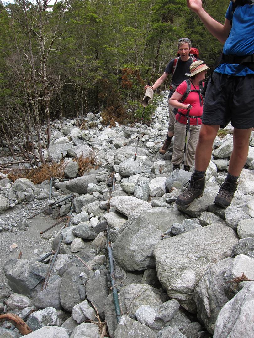
if you look at the green poles on the ground, that is the bridge that has been covered up by boulders moved by flood water...
from the land of the long white clouds...
-
wayno - Lagarostrobos franklinii
- Posts: 8784
- Joined: Sun 19 Jun, 2011 7:26 am
- Location: NZ
- Region: New Zealand
- Gender: Male
Re: tramper swept away on Milford Track
![]() by GPSGuided » Thu 22 May, 2014 9:04 am
by GPSGuided » Thu 22 May, 2014 9:04 am
On the emergency equipment discussion. Wayno, with your bivvy bag, do you also carry a sleeping bag with it? Knowing how cold NZ Sth island can get, is a single layer from a bivvy bag of sufficient help?
Just move it!
-

GPSGuided - Lagarostrobos franklinii
- Posts: 6968
- Joined: Mon 13 May, 2013 2:37 pm
- Location: Sydney
- Region: New South Wales
Re: tramper swept away on Milford Track
![]() by izogi » Thu 22 May, 2014 9:15 am
by izogi » Thu 22 May, 2014 9:15 am
I don't go anywhere on an intended multi-day trip without portable shelter, personally, and I sometimes take it on daytrips, too. It might be a bivy bag if I'm intending to be in huts, but I'll carry it. The hut network's awesome to have considering how much it rains, but if you slip and break an ankle in the rain then a back-country hut is not about to stand up and walk to you.
I mentioned in another forum that I think it's an oversight on DOC's Milford Track Winter Tramping page to not list portable shelter under its list of what to take. I don't see this as an adequate excuse to blame DOC for not taking it, and based on what I've read so far I'm not sure it would have made a difference for this group if DOC had listed it there. They apparently hadn't read the info on the same page about bridge removal, either. Camping on the track is illegal, but that bylaw is targeted at the booking season conveyor belt. Nobody's going to care about someone camping if the alternative is to risk death.
I mentioned in another forum that I think it's an oversight on DOC's Milford Track Winter Tramping page to not list portable shelter under its list of what to take. I don't see this as an adequate excuse to blame DOC for not taking it, and based on what I've read so far I'm not sure it would have made a difference for this group if DOC had listed it there. They apparently hadn't read the info on the same page about bridge removal, either. Camping on the track is illegal, but that bylaw is targeted at the booking season conveyor belt. Nobody's going to care about someone camping if the alternative is to risk death.
-

izogi - Atherosperma moschatum

- Posts: 66
- Joined: Fri 10 Sep, 2010 6:14 pm
- Region: New Zealand
- Gender: Male
Re: tramper swept away on Milford Track
![]() by wayno » Thu 22 May, 2014 9:17 am
by wayno » Thu 22 May, 2014 9:17 am
GPSGuided wrote:On the emergency equipment discussion. Wayno, with your bivvy bag, do you also carry a sleeping bag with it? Knowing how cold NZ Sth island can get, is a single layer from a bivvy bag of sufficient help?
always have a sleeping bag
from the land of the long white clouds...
-
wayno - Lagarostrobos franklinii
- Posts: 8784
- Joined: Sun 19 Jun, 2011 7:26 am
- Location: NZ
- Region: New Zealand
- Gender: Male
Re: tramper swept away on Milford Track
![]() by GPSGuided » Thu 22 May, 2014 9:36 am
by GPSGuided » Thu 22 May, 2014 9:36 am
wayno wrote:always have a sleeping bag
Makes sense.
Just move it!
-
GPSGuided - Lagarostrobos franklinii
- Posts: 6968
- Joined: Mon 13 May, 2013 2:37 pm
- Location: Sydney
- Region: New South Wales
Re: tramper swept away on Milford Track
![]() by wayno » Thu 22 May, 2014 10:41 am
by wayno » Thu 22 May, 2014 10:41 am
radio interview with milford track guide
http://www.radionz.co.nz/national/progr ... ford-track
http://www.radionz.co.nz/national/progr ... ford-track
from the land of the long white clouds...
-
wayno - Lagarostrobos franklinii
- Posts: 8784
- Joined: Sun 19 Jun, 2011 7:26 am
- Location: NZ
- Region: New Zealand
- Gender: Male
Re: tramper swept away on Milford Track
![]() by RonK » Thu 22 May, 2014 1:20 pm
by RonK » Thu 22 May, 2014 1:20 pm
wayno wrote:depends what you mean aboutcould a rope have helped
one method of using a rope is to tie it to your waist as you cross a water course while someone on hte river bank holds the other end .... as already commented thats a contentious method of crossing a river and can be very dangerous...
safer way is the person crossing to possibly hang onto the rope but that can easily end up unbalancing you.
or have a rope as backup to throw to someone if they get into trouble crossing..
Depends on the river of course but the pendulum method works if you have a good length of rope. The belayer needs to be as far upstream as possible.
-

RonK - Phyllocladus aspleniifolius
- Posts: 859
- Joined: Mon 31 Dec, 2012 10:33 am
- Region: Queensland
- Gender: Male
Re: tramper swept away on Milford Track
![]() by icefest » Thu 22 May, 2014 1:41 pm
by icefest » Thu 22 May, 2014 1:41 pm
You also need to pick a site where the current will push you to a safe landing spot if you do fall - this may vary depending on which side you belay from.RonK wrote:wayno wrote:depends what you mean aboutcould a rope have helped
one method of using a rope is to tie it to your waist as you cross a water course while someone on hte river bank holds the other end .... as already commented thats a contentious method of crossing a river and can be very dangerous...
safer way is the person crossing to possibly hang onto the rope but that can easily end up unbalancing you.
or have a rope as backup to throw to someone if they get into trouble crossing..
Depends on the river of course but the pendulum method works if you have a good length of rope. The belayer needs to be as far upstream as possible.
Men wanted for hazardous journey. Low wages, bitter cold, long hours of complete darkness. Safe return doubtful.
-

icefest - Lagarostrobos franklinii
- Posts: 4479
- Joined: Fri 27 May, 2011 11:19 pm
- Location: www.canyoninginvictoria.org
- Region: Victoria
Re: tramper swept away on Milford Track
![]() by GPSGuided » Thu 22 May, 2014 2:01 pm
by GPSGuided » Thu 22 May, 2014 2:01 pm
Would a 3 person combined crossing method (as seen on some Youtube video) have worked in this case? Or are the foot stepping rocks only accommodate one person at a time?
Just move it!
-
GPSGuided - Lagarostrobos franklinii
- Posts: 6968
- Joined: Mon 13 May, 2013 2:37 pm
- Location: Sydney
- Region: New South Wales
Re: tramper swept away on Milford Track
![]() by wayno » Thu 22 May, 2014 2:15 pm
by wayno » Thu 22 May, 2014 2:15 pm
GPSGuided wrote:Would a 3 person combined crossing method (as seen on some Youtube video) have worked in this case? Or are the foot stepping rocks only accommodate one person at a time?
they are just random rocks in the stream bed, not necesssarily stable for boulder hopping.
from the land of the long white clouds...
-
wayno - Lagarostrobos franklinii
- Posts: 8784
- Joined: Sun 19 Jun, 2011 7:26 am
- Location: NZ
- Region: New Zealand
- Gender: Male
Re: tramper swept away on Milford Track
![]() by GPSGuided » Thu 22 May, 2014 2:35 pm
by GPSGuided » Thu 22 May, 2014 2:35 pm
The various reports didn't give an indication of the water level. Yes, water reaching the knees can be mighty powerful yet often under-estimated.
Just move it!
-
GPSGuided - Lagarostrobos franklinii
- Posts: 6968
- Joined: Mon 13 May, 2013 2:37 pm
- Location: Sydney
- Region: New South Wales
Re: tramper swept away on Milford Track
![]() by wayno » Thu 22 May, 2014 3:25 pm
by wayno » Thu 22 May, 2014 3:25 pm
the river was 2 metres above normal level. if the river was that level i doubt I would have been attempting any side streams in those conditions.
from the land of the long white clouds...
-
wayno - Lagarostrobos franklinii
- Posts: 8784
- Joined: Sun 19 Jun, 2011 7:26 am
- Location: NZ
- Region: New Zealand
- Gender: Male
Re: tramper swept away on Milford Track
![]() by GPSGuided » Thu 22 May, 2014 3:28 pm
by GPSGuided » Thu 22 May, 2014 3:28 pm
If they've been tramping for a few days, would they have known the latest weather/river situation, as well as any associated warning?
Just move it!
-
GPSGuided - Lagarostrobos franklinii
- Posts: 6968
- Joined: Mon 13 May, 2013 2:37 pm
- Location: Sydney
- Region: New South Wales
Re: tramper swept away on Milford Track
![]() by wayno » Thu 22 May, 2014 3:30 pm
by wayno » Thu 22 May, 2014 3:30 pm
the river is plainly visible from the track for a reasonable part of that area
from the land of the long white clouds...
-
wayno - Lagarostrobos franklinii
- Posts: 8784
- Joined: Sun 19 Jun, 2011 7:26 am
- Location: NZ
- Region: New Zealand
- Gender: Male
Re: tramper swept away on Milford Track
![]() by photohiker » Thu 22 May, 2014 3:37 pm
by photohiker » Thu 22 May, 2014 3:37 pm
The river could not possibly have been 2m above normal level when they were crossing it. If it were, no one would have made it across.
Michael
-

photohiker - Lagarostrobos franklinii
- Posts: 3130
- Joined: Sun 17 May, 2009 12:31 pm
- Location: Adelaide, dreaming up where to go next.
Re: tramper swept away on Milford Track
![]() by wayno » Thu 22 May, 2014 3:39 pm
by wayno » Thu 22 May, 2014 3:39 pm
photohiker wrote:The river could not possibly have been 2m above normal level when they were crossing it. If it were, no one would have made it across.
they werent crossing the river they were crossing a side stream, i'm just saying knowing how high the river was running would put me off even attempting side streams, as a local guide commented on radio when it rains its like water pouring down the side of a bath, the watter runs off the mountains rapidly
from the land of the long white clouds...
-
wayno - Lagarostrobos franklinii
- Posts: 8784
- Joined: Sun 19 Jun, 2011 7:26 am
- Location: NZ
- Region: New Zealand
- Gender: Male
Re: tramper swept away on Milford Track
![]() by GPSGuided » Thu 22 May, 2014 3:43 pm
by GPSGuided » Thu 22 May, 2014 3:43 pm
Guess that's the point. Not being local, would they have known the normal water level?
Just move it!
-
GPSGuided - Lagarostrobos franklinii
- Posts: 6968
- Joined: Mon 13 May, 2013 2:37 pm
- Location: Sydney
- Region: New South Wales
Re: tramper swept away on Milford Track
![]() by wayno » Thu 22 May, 2014 3:48 pm
by wayno » Thu 22 May, 2014 3:48 pm
well for the river to be up that high it would have been pouring with rain for a long period of time...
that is warning sign enough in itself that water courses will be above normal the milford consists of two long valleys with massive walls of rock climbing up to 2000m that catch the rain and funnel it into the main river.
http://www.topomap.co.nz/NZTopoMap/nz14 ... /Southland
that is warning sign enough in itself that water courses will be above normal the milford consists of two long valleys with massive walls of rock climbing up to 2000m that catch the rain and funnel it into the main river.
http://www.topomap.co.nz/NZTopoMap/nz14 ... /Southland
from the land of the long white clouds...
-
wayno - Lagarostrobos franklinii
- Posts: 8784
- Joined: Sun 19 Jun, 2011 7:26 am
- Location: NZ
- Region: New Zealand
- Gender: Male
Re: tramper swept away on Milford Track
![]() by GPSGuided » Thu 22 May, 2014 3:50 pm
by GPSGuided » Thu 22 May, 2014 3:50 pm
But the question is, does DOC have facilities to warn trampers along that route at each of the huts? Not making a judgement on whether they should but just a question on whether there is.
Just move it!
-
GPSGuided - Lagarostrobos franklinii
- Posts: 6968
- Joined: Mon 13 May, 2013 2:37 pm
- Location: Sydney
- Region: New South Wales
Re: tramper swept away on Milford Track
![]() by RonK » Thu 22 May, 2014 3:53 pm
by RonK » Thu 22 May, 2014 3:53 pm
This is a picture of Pompolona Creek, from a trampers journal. It doesn't show the deepest part, and presumably the bridge has been removed for winter. I'll leave it to your imagination how powerful the flow would be in flood.
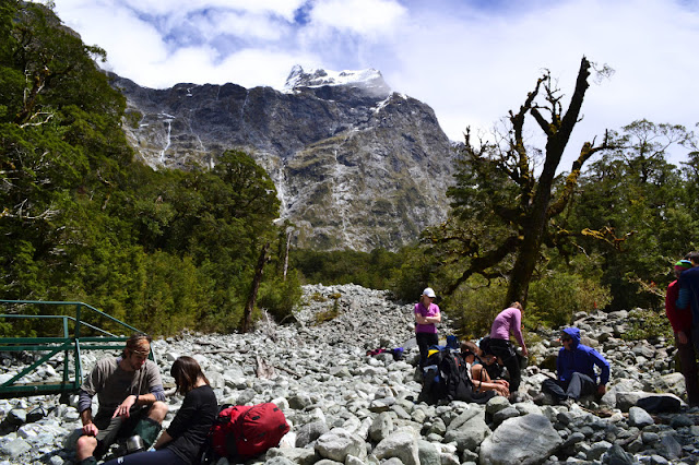
Here's another picture which the tramper called Marlene's Creek, but it's pretty clearly the same one. He commented that there was no need to stop at the Bus Shelter as the creek was just a trickle.

Here's another picture which the tramper called Marlene's Creek, but it's pretty clearly the same one. He commented that there was no need to stop at the Bus Shelter as the creek was just a trickle.
Last edited by RonK on Thu 22 May, 2014 4:01 pm, edited 1 time in total.
-
RonK - Phyllocladus aspleniifolius
- Posts: 859
- Joined: Mon 31 Dec, 2012 10:33 am
- Region: Queensland
- Gender: Male
Re: tramper swept away on Milford Track
![]() by wayno » Thu 22 May, 2014 3:57 pm
by wayno » Thu 22 May, 2014 3:57 pm
during the summer season there are rangers stationed at all the huts, they have regular radio contact with their main office and give weather updates every day to the trampers, they will advise trampers whether they can continue on the track or not, or summon helicopters if the rivers rise too much.. the rivers overflow onto the track in several places when it floods. but the water is pretty slow flowing and its possible to wade through it when its waist deep.
outside of the summer season after april there are no rangers stationed at the huts permanently, i'm not aware if they leave any rangers behind for any length of time...
once winter takes a hold avalanche danger eventually builds up along the walk, making it too dangerous to attempt
outside of the summer season after april there are no rangers stationed at the huts permanently, i'm not aware if they leave any rangers behind for any length of time...
once winter takes a hold avalanche danger eventually builds up along the walk, making it too dangerous to attempt
from the land of the long white clouds...
-
wayno - Lagarostrobos franklinii
- Posts: 8784
- Joined: Sun 19 Jun, 2011 7:26 am
- Location: NZ
- Region: New Zealand
- Gender: Male
Re: tramper swept away on Milford Track
![]() by wayno » Thu 22 May, 2014 3:59 pm
by wayno » Thu 22 May, 2014 3:59 pm
ron. that green structure on the left of the photo is the end of the bridge.
there are various photos on the internet labelled pompolona creek, some show a creek with a larger permanent bridge, some show this creek... i havent come across anyone i know who can emphatically say which creek it is...
there are various photos on the internet labelled pompolona creek, some show a creek with a larger permanent bridge, some show this creek... i havent come across anyone i know who can emphatically say which creek it is...
from the land of the long white clouds...
-
wayno - Lagarostrobos franklinii
- Posts: 8784
- Joined: Sun 19 Jun, 2011 7:26 am
- Location: NZ
- Region: New Zealand
- Gender: Male
Re: tramper swept away on Milford Track
![]() by photohiker » Thu 22 May, 2014 4:02 pm
by photohiker » Thu 22 May, 2014 4:02 pm
wayno wrote:photohiker wrote:The river could not possibly have been 2m above normal level when they were crossing it. If it were, no one would have made it across.
they werent crossing the river they were crossing a side stream, i'm just saying knowing how high the river was running would put me off even attempting side streams, as a local guide commented on radio when it rains its like water pouring down the side of a bath, the watter runs off the mountains rapidly
Got it. thanks.
Sounds like the Scottish Highlands then. When it rains, little creeks turn into raging torrents in no time. Very little water absorbed in the hills, it all runs off. Quite amazing to watch a river seems to appear from nowhere and crashes down the hillside.
Michael
-
photohiker - Lagarostrobos franklinii
- Posts: 3130
- Joined: Sun 17 May, 2009 12:31 pm
- Location: Adelaide, dreaming up where to go next.
Re: tramper swept away on Milford Track
![]() by wayno » Thu 22 May, 2014 4:09 pm
by wayno » Thu 22 May, 2014 4:09 pm
this is the routeburn in those sorts of conditions, when 300mm of rain fell in a day.
it sounded like standing next to a jumbo jet taking off....
this is the routeburn at low flow
it sounded like standing next to a jumbo jet taking off....
this is the routeburn at low flow
- Attachments
-
-
-
- same location from the side
from the land of the long white clouds...
-
wayno - Lagarostrobos franklinii
- Posts: 8784
- Joined: Sun 19 Jun, 2011 7:26 am
- Location: NZ
- Region: New Zealand
- Gender: Male
Re: tramper swept away on Milford Track
![]() by RonK » Thu 22 May, 2014 5:31 pm
by RonK » Thu 22 May, 2014 5:31 pm
wayno wrote:ron. that green structure on the left of the photo is the end of the bridge.
there are various photos on the internet labelled pompolona creek, some show a creek with a larger permanent bridge, some show this creek... i havent come across anyone i know who can emphatically say which creek it is...
It probably doesn't really matter that much wayno - the pictures show that these side creeks are not just gentle watercourses, they are actually avalanche chutes and may be extremely dangerous even when the flow is small.
I'd be interest to get your take on Kevin Biggar and Jamie Fitzgerald. I watched their documentary series First Crossings, and whilst I though they dramatized things a bit, the series did show that even apparently experienced trampers can make serious misjudgments. Are they fair dinkum, do you think?
In series 1, episode 2 they re-created Grave and Talbot's first crossing of the Darran Mountains to Milford, and one of the first scenes was crossing a river by rope - as I recall it was actually the Clinton River.
Ultimately it was the trampers decision to enter what must have been a raging torrent. I can't image how they could have made that decision because the flow must have been very intimidating.
Here's another trampers journal with pictures and comments about the warning they received.
-
RonK - Phyllocladus aspleniifolius
- Posts: 859
- Joined: Mon 31 Dec, 2012 10:33 am
- Region: Queensland
- Gender: Male
Re: tramper swept away on Milford Track
![]() by wayno » Thu 22 May, 2014 5:41 pm
by wayno » Thu 22 May, 2014 5:41 pm
the first crossing series they have wire cables supporting them during dangerous climbing segments, the cables are then edited out...
they are a bit gung ho, especially on the buller river, evidenced when they jumped into the river and one of them got sucked under by the current and nearly drowned... sometimes i'm not convinced about the routes they take, some i think may just be there for show to dramatise things, although they are also trying to recreate events that were commented about by the original adventurers.
they are ALWAYS CLEAN SHAVEN. and they always have abundant energy, so they must be getting a lot of additional support on these multi day trips.... they must be getting regular good feeds and eating more than the food they show they carry... sponsor is the north face, so i'm guessing they have some nice comfy clothes, tents and sleeping bags to retire to when they need them...
but still its a great watch and they've done well to get it onto tv and DVD and they are still out there making a massive effort in some very difficult places, better to be safe than sorry
one scene i could make out the shape of residual floatation devices underneath their shirts when they did one river crossing,
it would be more honest to tell people how much support they get, otherwise its a case of telling kids "don't try this at home"
from the land of the long white clouds...
-
wayno - Lagarostrobos franklinii
- Posts: 8784
- Joined: Sun 19 Jun, 2011 7:26 am
- Location: NZ
- Region: New Zealand
- Gender: Male
91 posts
• Page 2 of 4 • 1, 2, 3, 4
Who is online
Users browsing this forum: No registered users and 16 guests