Hi guys,
So we were planning to hike the Western and Eastern Arthurs in April, but unfortunately need to change our plans due to trail closures. With two weeks to spend, we're looking for alternative multi-day hikes anywhere in Tasmania, if possible accessible by public transport as we won't have a car. We're thinking of flying to Malaleuca, hiking to South West Cape (is there any trail there? and if not, do we need a permit for hiking off the trail?) and the then South Coast Track. We've also read about the Overland Track, but we're not too keen to book campgrounds and all that in advance.
We're both quite fit and experienced hikers and like remote trails, particularly with mountain views.
Thanks in advance for recommendations!
Arthurs closed... Alternatives needed
Forum rules
Tasmania specific bushwalking discussion. Please avoid publishing details of access to sensitive areas with no tracks.
Tasmania specific bushwalking discussion. Please avoid publishing details of access to sensitive areas with no tracks.
25 posts
• Page 1 of 1
Arthurs closed... Alternatives needed
![]() by Araucaria » Sat 23 Mar, 2019 11:33 am
by Araucaria » Sat 23 Mar, 2019 11:33 am
-

Araucaria - Nothofagus gunnii

- Posts: 29
- Joined: Sat 23 Mar, 2019 11:19 am
- Region: Victoria
Re: Arthurs closed... Alternatives needed
![]() by north-north-west » Sun 24 Mar, 2019 2:14 pm
by north-north-west » Sun 24 Mar, 2019 2:14 pm
All you need is a parks pass - same one you would have needed for the Arthurs.
The South West Cape circuit is tracked to Wilson Bight. Beyond that it's a variable pad, some of which is heavily overgrown. You need to be able to navigate off-track and to carry decent maps and notes. If you don't already have it, get Chapman's South West Tasmania book which has detailed notes on the route.
Unfortunately, most of the better off-track walks in the SW (Wilmot-Frankland, Denisons, Spires) are also closed, so options for longer walks are limited. Southern Range and South Coast circuit is one, although transport to/from Ida Bay and Cockle Creek can be tricky. Or - if you really want to go hard-core - you could do the Eldon traverse, starting at Lake Burbury and exiting either via Pigeonhouse or over Goulds Sugarloaf to Cuvier and Lake Petrarch and the Cuvier Valley. Both of those offer reasonable mountain scenery. The Southern Range option is easier, but there is reliable (if not overly frequent) bus transport on the Lyell Hway.
If there are just two of you, hitching would work. Or if the timing is right I could be persuaded to drive you to wherever you want to start if you cover the fuel costs and buy me enough Coke and chocolate for the journey...
"Mit der Dummheit kämpfen Götter selbst vergebens."
-

north-north-west - Lagarostrobos franklinii

- Posts: 15134
- Joined: Thu 14 May, 2009 7:36 pm
- Location: The Asylum
- ASSOCIATED ORGANISATIONS: Social Misfits Anonymous
- Region: Tasmania
Re: Arthurs closed... Alternatives needed
![]() by DaveNoble » Sun 24 Mar, 2019 7:06 pm
by DaveNoble » Sun 24 Mar, 2019 7:06 pm
Good public transport options that feature great mountain scenery could be - Frenchmans Cap (3 - 4 days), and a walk in the southern part of Cradle Mts Lake St Clair National Park - eg to Pine Valley and the Du Cane Range - you can easily spend 4 - 10 days, and the scenery is as good as anything in Tasmania. Both are accessible from the bus service up the Lyell Highway. You can download the Tassielink timetable, but the service may only be 3 or 4 days a week to or from Hobart. There are other services to and from Launceston to Cynthia Bay on Lake St Clair.
- DaveNoble
- Athrotaxis selaginoides

- Posts: 1031
- Joined: Sun 03 Feb, 2008 3:56 pm
Re: Arthurs closed... Alternatives needed
![]() by Araucaria » Wed 27 Mar, 2019 1:48 pm
by Araucaria » Wed 27 Mar, 2019 1:48 pm
Thank you both for the recommendations. We're still considering different options and have a few questions:
1) You both mentioned bus service along the Lyell Hway (A10?) - I haven't found any Tassielink service there, could you provide more details please?
2) Du Cane Range looks great. Any recommendation on which nearby hike we can add to that to fill our 2-week vacation (and possibly add some variety in landscape)? Also, as we may not be able to fit 10+ days' worth of food in our packs - any ideas on where to resupply in the area?
north-north-west, many thanks for your kind offer. We'll keep in touch!
-
Araucaria - Nothofagus gunnii
- Posts: 29
- Joined: Sat 23 Mar, 2019 11:19 am
- Region: Victoria
Re: Arthurs closed... Alternatives needed
![]() by rangersac » Wed 27 Mar, 2019 1:54 pm
by rangersac » Wed 27 Mar, 2019 1:54 pm
The Tassielink service via the Lyell Hwy stopped on 10th March. You can only get as far as Hamilton now by public transport.
- rangersac
- Athrotaxis cupressoides

- Posts: 100
- Joined: Mon 16 Apr, 2018 9:01 am
- Region: Tasmania
Re: Arthurs closed... Alternatives needed
![]() by philm » Wed 27 Mar, 2019 1:57 pm
by philm » Wed 27 Mar, 2019 1:57 pm
Plenty of options around
The Du Cane then across the Traveller range from the gatepost track. On the traveller it is all off track but Yu could go to Lake Artemis which is great then from there the Mountains of
Jupiter then head further South off track and eventually rejoin the overland track near Lake St Clare.
If you want to resupply then leave food at Lake St Clair so the Du Cane then walk back. I would just take the 10 days of food with me
-
philm - Athrotaxis cupressoides
- Posts: 477
- Joined: Sat 06 Nov, 2010 10:49 am
- Region: South Australia
- Gender: Male
Re: Arthurs closed... Alternatives needed
![]() by Violet_Femme » Wed 10 Apr, 2019 2:17 pm
by Violet_Femme » Wed 10 Apr, 2019 2:17 pm
rangersac wrote:The Tassielink service via the Lyell Hwy stopped on 10th March. You can only get as far as Hamilton now by public transport.
Yikes yes, I just got caught out by this when I was double checking my transport plans for my Frenchman's cap & Pine Valley trip in Easter. Now running around to see if I can still go or make other plans ....
- Violet_Femme
- Atherosperma moschatum

- Posts: 55
- Joined: Sun 01 Feb, 2015 8:53 am
- Region: New South Wales
Re: Arthurs closed... Alternatives needed
![]() by Violet_Femme » Wed 10 Apr, 2019 2:17 pm
by Violet_Femme » Wed 10 Apr, 2019 2:17 pm
rangersac wrote:The Tassielink service via the Lyell Hwy stopped on 10th March. You can only get as far as Hamilton now by public transport.
Yikes yes, I just got caught out by this when I was double checking my transport plans for my Frenchman's cap & Pine Valley trip in Easter. Now running around to see if I can still go or make other plans ....
- Violet_Femme
- Atherosperma moschatum
- Posts: 55
- Joined: Sun 01 Feb, 2015 8:53 am
- Region: New South Wales
Re: Arthurs closed... Alternatives needed
![]() by Araucaria » Wed 17 Jul, 2019 3:11 pm
by Araucaria » Wed 17 Jul, 2019 3:11 pm
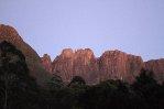
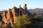
Thanks everyone for your suggestions! We teamed up with Lesley who was looking for hiking companions in another thread here, and decided to hike the Southern Ranges (back on the South Coast Track) and then the Du Cane area. We weren't too lucky with the weather in the south, but we greatly enjoyed the hike anyway (we still haven't forgotten the bushes though!). The PB is one of the most beautiful mountains we've seen and we hope to visit Tasmania again. Here are some pictures from our trip:
https://photos.app.goo.gl/ZHzze7fiKENVgktV7
The captions are hidden by default, please click on the "i" icon in the top right corner to see them.
https://photos.app.goo.gl/ZHzze7fiKENVgktV7
The captions are hidden by default, please click on the "i" icon in the top right corner to see them.
-
Araucaria - Nothofagus gunnii
- Posts: 29
- Joined: Sat 23 Mar, 2019 11:19 am
- Region: Victoria
Re: Arthurs closed... Alternatives needed
![]() by Wollemi » Wed 17 Jul, 2019 9:28 pm
by Wollemi » Wed 17 Jul, 2019 9:28 pm
Well done on your walking in Tasmania. Did you really carry a medium-format camera with a bellows? Anyway, if I may say - that grey closed-cell sleeping mat should be carried in a tough bag - or may have fitted in the woman's backpack. The closed-cell mats have been shown to break down in shrubbery, from several centimetres size to micro-plastics in waterways. Do this anywhere in the world, please - rocks and shrubbery will fragment the mat.
Live everyday as if it were your last... one day you will be right.
- Wollemi
- Athrotaxis cupressoides
- Posts: 275
- Joined: Tue 24 Jul, 2012 10:32 am
- Location: lower Blue Mts
- Region: New South Wales
- Gender: Male
Re: Arthurs closed... Alternatives needed
![]() by Araucaria » Wed 17 Jul, 2019 9:36 pm
by Araucaria » Wed 17 Jul, 2019 9:36 pm
Hi, thanks for the comment. We do our best to leave no trace and certainly don't leave anything behind, but we didn't think about the microplastics. We'll make sure to be more careful next time we are bushwalking.
Regarding the medium-format camera, it wasn't us, but a guy whom we met in the Labirynth. He also had a 4 kg tripod We mentioned it in the caption to the photo (you can see all captions if you click on the "i" icon in the top right corner.
Regarding the medium-format camera, it wasn't us, but a guy whom we met in the Labirynth. He also had a 4 kg tripod
-
Araucaria - Nothofagus gunnii
- Posts: 29
- Joined: Sat 23 Mar, 2019 11:19 am
- Region: Victoria
Re: Arthurs closed... Alternatives needed
![]() by ILUVSWTAS » Thu 18 Jul, 2019 6:39 am
by ILUVSWTAS » Thu 18 Jul, 2019 6:39 am
Wollemi wrote:Well done on your walking in Tasmania. Did you really carry a medium-format camera with a bellows? Anyway, if I may say - that grey closed-cell sleeping mat should be carried in a tough bag - or may have fitted in the woman's backpack. The closed-cell mats have been shown to break down in shrubbery, from several centimetres size to micro-plastics in waterways. Do this anywhere in the world, please - rocks and shrubbery will fragment the mat.
Great advice. Especially somewhere like the Southern Ranges where the Scorparia will shred it.
I cant deal with having things on the outside of my pack. Besides getting shredded you run the risk of losing the object (i've seen tent poles disappear like this) or it becoming soaking wet. Pack less or get a bigger backpack!!
Nothing to see here.
-

ILUVSWTAS - Lagarostrobos franklinii
- Posts: 11046
- Joined: Sun 28 Dec, 2008 9:53 am
- Region: Tasmania
- Gender: Male
Re: Arthurs closed... Alternatives needed
![]() by Araucaria » Fri 19 Jul, 2019 6:13 pm
by Araucaria » Fri 19 Jul, 2019 6:13 pm
ILUVSWTAS wrote:I cant deal with having things on the outside of my pack.
No one tells you to
I like having the sleeping mat outside of the pack. It's easier to pack in the morning plus I can quickly take it off and use it as a seat during breaks. In the backpack side-pockets I keep gloves, a cap and a water bottle - I can easily reach the items without taking the backpack off. In Canada I also kept a bear spray in the pocket, it's not something you want to have inside your pack when hiking
-
Araucaria - Nothofagus gunnii
- Posts: 29
- Joined: Sat 23 Mar, 2019 11:19 am
- Region: Victoria
Re: Arthurs closed... Alternatives needed
![]() by Overlandman » Wed 07 Aug, 2019 3:57 pm
by Overlandman » Wed 07 Aug, 2019 3:57 pm
Update from ABC
https://www.abc.net.au/news/2019-08-07/ ... t/11389336
Walking tracks to remain closed
The popular Mount Anne and Arthur Ranges walking tracks will remain closed indefinitely due to the extensive bushfire damage they suffered in January this year.
Head of Tasmanian Parks and Wildlife Jason Jacobi said the affected tracks were unlikely to be reopened within the next 12 months.
"The extent of the damage is significant and obviously it's going to take many months and, in some locations, well over a year to get those tracks rebuilt and restored to their original condition," he said.
Whatever, Wherever, Whenever
- Overlandman
- Athrotaxis selaginoides
- Posts: 1566
- Joined: Sun 13 Nov, 2011 5:22 pm
- Location: Tasmania
- Region: Tasmania
- Gender: Male
Re: Arthurs closed... Alternatives needed
![]() by L_Cham_67 » Wed 07 Aug, 2019 4:10 pm
by L_Cham_67 » Wed 07 Aug, 2019 4:10 pm
I'm assuming they're referring to the Eastern Arthurs, as the Western end did get reopened?
-

L_Cham_67 - Athrotaxis selaginoides
- Posts: 1045
- Joined: Thu 17 Dec, 2015 6:43 pm
- Region: Tasmania
- Gender: Male
Re: Arthurs closed... Alternatives needed
![]() by bogholesbuckethats » Wed 07 Aug, 2019 4:27 pm
by bogholesbuckethats » Wed 07 Aug, 2019 4:27 pm
Quote from Jason Jacobi
"We have plans underway and staff actively working on formalising contracts and designs for the restoration and reopening of those parks (Anne and Eastern Arthurs"
Not quite sure why they need redesign some duckboards and steps, unless he is referring to the hut on the way to the Eliza Plateau? I'm not even sure if it was burnt in the fires.
Reopening the Arthur Plains or Farmhouse Creek track shouldn't require much designing. Please let me know if i'm missing something.
That looks like a pad.
-

bogholesbuckethats - Phyllocladus aspleniifolius

- Posts: 583
- Joined: Mon 02 Oct, 2017 12:06 pm
- Location: Hobart
- Region: Tasmania
- Gender: Male
Re: Arthurs closed... Alternatives needed
![]() by eggs » Wed 07 Aug, 2019 4:36 pm
by eggs » Wed 07 Aug, 2019 4:36 pm
Did the fire affect the toilet at High Camp Hut?
We were very disappointed with the state of things up there in Mar 2018.
The door had come off the hut and the toilet was designed to allow weather from the south-west to pour in through the air gaps meaning the occupant got soaked.
And it was a new toilet!!??
We were very disappointed with the state of things up there in Mar 2018.
The door had come off the hut and the toilet was designed to allow weather from the south-west to pour in through the air gaps meaning the occupant got soaked.
And it was a new toilet!!??
-
eggs - Lagarostrobos franklinii
- Posts: 10469
- Joined: Fri 23 May, 2008 2:58 pm
- Location: Para Vista, South Australia
- Region: South Australia
Re: Arthurs closed... Alternatives needed
![]() by ILUVSWTAS » Wed 07 Aug, 2019 6:07 pm
by ILUVSWTAS » Wed 07 Aug, 2019 6:07 pm
L_Cham_67 wrote:I'm assuming they're referring to the Eastern Arthurs, as the Western end did get reopened?
Only A-K is open.
And with all these track closures I'm cringing a little at the thought of all the extra traffic that will impact the few remaining multi day walks that are open.
Nothing to see here.
-
ILUVSWTAS - Lagarostrobos franklinii
- Posts: 11046
- Joined: Sun 28 Dec, 2008 9:53 am
- Region: Tasmania
- Gender: Male
Re: Arthurs closed... Alternatives needed
![]() by north-north-west » Wed 07 Aug, 2019 6:26 pm
by north-north-west » Wed 07 Aug, 2019 6:26 pm
ILUVSWTAS wrote:And with all these track closures I'm cringing a little at the thought of all the extra traffic that will impact the few remaining multi day walks that are open.
Send 'em into the White Monoliths. That'll sort the wannabes from the real walkers.
I do not understand why Kappa to Roseanne can't be opened, as there is sod all infrastructure in that section of the WArthurs. The only issue would be all the duckboarding around Cracroft Crossing, and maybe treefalls in the plains.
"Mit der Dummheit kämpfen Götter selbst vergebens."
-
north-north-west - Lagarostrobos franklinii
- Posts: 15134
- Joined: Thu 14 May, 2009 7:36 pm
- Location: The Asylum
- ASSOCIATED ORGANISATIONS: Social Misfits Anonymous
- Region: Tasmania
Re: Arthurs closed... Alternatives needed
![]() by epiclad25 » Tue 21 Jul, 2020 12:42 pm
by epiclad25 » Tue 21 Jul, 2020 12:42 pm
Hi all
I need some info on the Franklands. Specifically, the amount of scrambling involved so I can decide whether to take a harness etc or if I can do with a rope. I also am wondering if it is possible to walk from pebbly creek to red knoll in a day.
Cheers
I need some info on the Franklands. Specifically, the amount of scrambling involved so I can decide whether to take a harness etc or if I can do with a rope. I also am wondering if it is possible to walk from pebbly creek to red knoll in a day.
Cheers
- epiclad25
- Nothofagus gunnii
- Posts: 15
- Joined: Sun 01 Mar, 2020 3:38 pm
- Region: Queensland
- Gender: Male
Re: Arthurs closed... Alternatives needed
![]() by north-north-west » Tue 21 Jul, 2020 4:21 pm
by north-north-west » Tue 21 Jul, 2020 4:21 pm
Ropes aren't needed unless perhaps between Frankland and Secheron, and on some descent lines from Secheron, and that would only be for pack-hauling. Easier - if a trifle further - to go out via Giblin and Jim Brown. Secheron, Terminal and Lloyd Jones can be done as a side trip from Frankland, although it might make for a long day.
Which one is Pebbly Creek - between Terminal/Lloyd Jones and Giblin/Jim Brown? I went from the flats just south of the latter to Red Knoll in a fairly leisurely five or six hours, but the water level was relatively low so I was on dry ground all the way. If the water level is higher wading would be necessary and that would slow you down a lot. Doesn't Chapman go into that in the book?
Are you aware of what you're biting off with that range? The Wilmot-Frankland traverse is off-track from Sprent until you hit the old line of McKays below Red Knoll. It's very exposed to the very worst weather Tassie can throw at you.
"Mit der Dummheit kämpfen Götter selbst vergebens."
-
north-north-west - Lagarostrobos franklinii
- Posts: 15134
- Joined: Thu 14 May, 2009 7:36 pm
- Location: The Asylum
- ASSOCIATED ORGANISATIONS: Social Misfits Anonymous
- Region: Tasmania
Re: Arthurs closed... Alternatives needed
![]() by JamesMc » Tue 21 Jul, 2020 8:59 pm
by JamesMc » Tue 21 Jul, 2020 8:59 pm
If I remember right (it was early 1984) we lowered packs down the lower part of the descent gully from Frankland Peak. Descending Secheron Peak there were a few little cliffs of a couple of metres where we could pass packs from one person to another but it was very exposed. A couple of exposed sections descending Mt Lloyd Jones too. We didn't have any route guide for the section east of Frankland Pd other than an old Tasmanian Tramp article so there may have been a better way to go. Been meaning to get back there!
JamesMc
JamesMc
- JamesMc
- Athrotaxis cupressoides
- Posts: 263
- Joined: Wed 09 Dec, 2009 5:24 pm
- Region: Victoria
- Gender: Male
Re: Arthurs closed... Alternatives needed
![]() by north-north-west » Wed 22 Jul, 2020 7:32 am
by north-north-west » Wed 22 Jul, 2020 7:32 am
JamesMc wrote:If I remember right (it was early 1984) we lowered packs down the lower part of the descent gully from Frankland Peak. Descending Secheron Peak there were a few little cliffs of a couple of metres where we could pass packs from one person to another but it was very exposed. A couple of exposed sections descending Mt Lloyd Jones too. We didn't have any route guide for the section east of Frankland Pd other than an old Tasmanian Tramp article so there may have been a better way to go. Been meaning to get back there!
I did Terminal and Lloyd Jones as a separate trip from near Kostka Point. It's easy enough to do it without any scrambling to speak of - you use my descent route, but not the far more fun ascent line. Just don't try to go straight; sidle around a bit south and east via green ramps.
"Mit der Dummheit kämpfen Götter selbst vergebens."
-
north-north-west - Lagarostrobos franklinii
- Posts: 15134
- Joined: Thu 14 May, 2009 7:36 pm
- Location: The Asylum
- ASSOCIATED ORGANISATIONS: Social Misfits Anonymous
- Region: Tasmania
Re: Arthurs closed... Alternatives needed
![]() by Azza » Wed 22 Jul, 2020 3:44 pm
by Azza » Wed 22 Jul, 2020 3:44 pm
I've marched out to Red Knoll from Frankland Peak in a day, down to Jones Pass / Pebbly Creek then traversed the Giblin Range.
It was a very long day. I think we got off Jim Brown at about 4pm and took off around the lake and made Red Knoll not long before dusk in the middle of summer.
I wouldn't recommend it as "the plan", but from Pebbly Creek it would be more comfortable to walk out I would think.
We had light packs and been rained on for days so there was a desire to get out of there.
-

Azza - Phyllocladus aspleniifolius
- Posts: 980
- Joined: Thu 06 Mar, 2008 11:26 am
Re: Arthurs closed... Alternatives needed
![]() by epiclad25 » Thu 23 Jul, 2020 7:17 am
by epiclad25 » Thu 23 Jul, 2020 7:17 am
north-north-west wrote:Ropes aren't needed unless perhaps between Frankland and Secheron, and on some descent lines from Secheron, and that would only be for pack-hauling. Easier - if a trifle further - to go out via Giblin and Jim Brown. Secheron, Terminal and Lloyd Jones can be done as a side trip from Frankland, although it might make for a long day.
Which one is Pebbly Creek - between Terminal/Lloyd Jones and Giblin/Jim Brown? I went from the flats just south of the latter to Red Knoll in a fairly leisurely five or six hours, but the water level was relatively low so I was on dry ground all the way. If the water level is higher wading would be necessary and that would slow you down a lot. Doesn't Chapman go into that in the book?
Are you aware of what you're biting off with that range? The Wilmot-Frankland traverse is off-track from Sprent until you hit the old line of McKays below Red Knoll. It's very exposed to the very worst weather Tassie can throw at you.
yeah. I am going with my father at least and maybe my uncle. both have done the western arthurs and fedder as well as a lot of of track walking in other areas. my dad has done the whole eastern arthurs traverse also. I reckon with a bit of planning we will be ok. I myself am fairly experienced with tassie weather having lived there for ten years. most of that was spent in the huon valley and I did a lot of walking including hartz peak in winter, camping out there also. I ask only because I was wondering if I would need some safety equipment. I am relatively practised in scrambling having done walking on both mount barney and the glass house mountains. I mean it certainly isn't impressive but I am a young guy and so it is't too bad either.
- epiclad25
- Nothofagus gunnii
- Posts: 15
- Joined: Sun 01 Mar, 2020 3:38 pm
- Region: Queensland
- Gender: Male
25 posts
• Page 1 of 1
Who is online
Users browsing this forum: phATty and 38 guests