hi,
i'm looking to go to check out McGowans falls and wondering how I get to the head of the track and what condition the track is in. I think there's a track starting somewhere off Relapse Creek Road or Relapse Link Road, but that's all I can find, gleaned from Tassietrekkers blog.
Also, what is and where is Victory Springs? Worth a visit?
thanks all,
Ben
How to get to McGowans falls
Forum rules
Tasmania specific bushwalking discussion. Please avoid publishing details of access to sensitive areas with no tracks.
Tasmania specific bushwalking discussion. Please avoid publishing details of access to sensitive areas with no tracks.
15 posts
• Page 1 of 1
How to get to McGowans falls
![]() by dookanooka » Thu 24 Dec, 2009 11:02 am
by dookanooka » Thu 24 Dec, 2009 11:02 am
- dookanooka
- Nothofagus cunninghamii

- Posts: 4
- Joined: Thu 17 Sep, 2009 3:25 pm
- Region: Tasmania
- Gender: Male
Re: How to get to McGowans falls
![]() by GerryDuke » Fri 25 Dec, 2009 12:19 pm
by GerryDuke » Fri 25 Dec, 2009 12:19 pm
I am keen to verify the location of the track myself Ben. I wandered down that way 8 years ago. I found what I presume was the track on Relapse Creek Road. There was a rock cairn of sorts by the side of the road where the map indicated the track should have been. Walked in for a little way. The 'track' was flanked by cutting grass. Being summer (little water about) I decided not to go on. I am keen to go back but after rain.
I also drove down to Farquhars Bridge. The map shows Victory Springs just before the bridge but I did not notice any indication of where or what they are!
Merry Christmas,
Gerry
I also drove down to Farquhars Bridge. The map shows Victory Springs just before the bridge but I did not notice any indication of where or what they are!
- FARQUHARS_BRIDGE_13_01-013.jpg (67.43 KiB) Viewed 7654 times
Merry Christmas,
Gerry
-
GerryDuke - Athrotaxis cupressoides

- Posts: 403
- Joined: Sun 18 May, 2008 12:04 am
- Location: KINGSTON BEACH, TASMANIA
- ASSOCIATED ORGANISATIONS: Operator of www.TouringTasmania.info web site
- Region: Tasmania
- Gender: Male
Re: How to get to McGowans falls
![]() by sirius Tas » Sun 27 Dec, 2009 11:45 am
by sirius Tas » Sun 27 Dec, 2009 11:45 am
Have recently visited these falls on a geocaching excursion...quite speccy though at the time I didn't go to the bottom of falls...intending to go back during winter after substantial rain.
The details can be found at
http://geocaching.com.au/cache/ga1566
The track is quite good with a few minor trees across after the wind storm we had a few months back. I'm hoping to clear these off at some stage.
As for Victory Springs....no knowledge what so ever.
Cheers....sirius.
The details can be found at
http://geocaching.com.au/cache/ga1566
The track is quite good with a few minor trees across after the wind storm we had a few months back. I'm hoping to clear these off at some stage.
As for Victory Springs....no knowledge what so ever.
Cheers....sirius.
After a day's walk everything has twice its usual value.
-

sirius Tas - Athrotaxis cupressoides
- Posts: 181
- Joined: Fri 03 Oct, 2008 2:18 pm
- Location: Ulverstone
- Region: Tasmania
- Gender: Male
- dookanooka
- Nothofagus cunninghamii
- Posts: 4
- Joined: Thu 17 Sep, 2009 3:25 pm
- Region: Tasmania
- Gender: Male
Re: How to get to McGowans falls
![]() by MrCAMEL » Sat 02 Jan, 2010 8:49 pm
by MrCAMEL » Sat 02 Jan, 2010 8:49 pm
Mr Duke, I am going to play guess the car game. Is that your HQ?
But, was that picture of the bridge also taken only 8 years ago? I was (almost) sure, that I read somewhere that both Hilder's and Farquhar's Bridge had been broken for decades.
When did they actually break?
But, was that picture of the bridge also taken only 8 years ago? I was (almost) sure, that I read somewhere that both Hilder's and Farquhar's Bridge had been broken for decades.
When did they actually break?
Vrilen Snyson Racing: Finding us all a Vrilen
Asparagus: Experience the versatility
Asparagus: Experience the versatility
-

MrCAMEL - Athrotaxis cupressoides
- Posts: 104
- Joined: Fri 18 Jul, 2008 11:10 pm
- Location: Mongol Land
- Region: Other Country
Re: How to get to McGowans falls
![]() by tastrekker » Sat 02 Jan, 2010 9:45 pm
by tastrekker » Sat 02 Jan, 2010 9:45 pm
Being an old fashioned stickler for non-technological ways of navigating in the bush, here's the way I have always remembered the McGowans Falls track location since I was first shown the spot many many moons ago...
As you drive down Relapse Creek Road, you wind down the southern side of the Relapse Creek valley. Therefore there is a drop-off on your right and an embankment on your left. After a little way, the road briefly crosses the watershed between the Relapse Creek and Arthur River valleys so you have a drop on your left and an embankment on your right. The next bend in the road delivers you back to the Relapse Creek valley with a drop on your right and an embankment on your left. At the start of the next straight, the track enters the bush at an old spur road on your right. There's a scary insight into the way my brain works.
Here's the alternate method - Head approx 2km down Relapse Creek Road and look for a cairn with pink tape on your right!!!
I still like my first method as cairns and tape change much more rapidly than valleys and watersheds.
The walk to the bottom is great even in low water flows as the rock bands which the falls flow over are quite colourful. The colours are best appreciated when there is very little water.
-

tastrekker - Athrotaxis cupressoides
- Posts: 498
- Joined: Thu 20 Sep, 2007 9:04 pm
- Location: Lenah Valley
- Region: Tasmania
- Gender: Male
Re: How to get to McGowans falls
![]() by tastrekker » Sat 02 Jan, 2010 9:47 pm
by tastrekker » Sat 02 Jan, 2010 9:47 pm
Dear MrCamel,
I can partly answer your bridge question. Hilders Bridge has been gone for decades (not sure exactly how long). Farquhars Bridge went in the August 2007 floods which also washed away Tayetea Bridge.
I can partly answer your bridge question. Hilders Bridge has been gone for decades (not sure exactly how long). Farquhars Bridge went in the August 2007 floods which also washed away Tayetea Bridge.
-
tastrekker - Athrotaxis cupressoides
- Posts: 498
- Joined: Thu 20 Sep, 2007 9:04 pm
- Location: Lenah Valley
- Region: Tasmania
- Gender: Male
Re: How to get to McGowans falls
![]() by GerryDuke » Sat 02 Jan, 2010 11:51 pm
by GerryDuke » Sat 02 Jan, 2010 11:51 pm
Thanks TT for the info. I wondered if the bridge was still there. Yes MrC the picture was taken 8 years ago - my old Datsun Sunny at the time.
Gerry
Gerry
-
GerryDuke - Athrotaxis cupressoides
- Posts: 403
- Joined: Sun 18 May, 2008 12:04 am
- Location: KINGSTON BEACH, TASMANIA
- ASSOCIATED ORGANISATIONS: Operator of www.TouringTasmania.info web site
- Region: Tasmania
- Gender: Male
Re: How to get to McGowans falls
![]() by dookanooka » Wed 06 Jan, 2010 3:18 pm
by dookanooka » Wed 06 Jan, 2010 3:18 pm
very interesting everyone, i'll double the thanks with Gerry
- dookanooka
- Nothofagus cunninghamii
- Posts: 4
- Joined: Thu 17 Sep, 2009 3:25 pm
- Region: Tasmania
- Gender: Male
Re: How to get to McGowans falls
![]() by NWDANIEL » Mon 25 Jan, 2010 9:54 am
by NWDANIEL » Mon 25 Jan, 2010 9:54 am
Bit off topic but can anyone give me directions to get to Heaven from Hilders Crossing GPS Coords would be great for heaven if anyone has them. The Track for Mcgowans Falls starts at S 41'09.848 E 145'27.325 Cheers
- NWDANIEL
- Nothofagus cunninghamii
- Posts: 2
- Joined: Sun 17 Jan, 2010 7:50 pm
- Region: Tasmania
- Gender: Male
Re: How to get to McGowans falls
![]() by tastrekker » Mon 25 Jan, 2010 4:05 pm
by tastrekker » Mon 25 Jan, 2010 4:05 pm
Check out my entries on the Tarkine Falls/Rainforest Track topic for a detailed answer to your question about 'Heaven'. I can't give GPS co-ords but (as mentioned in the other topic), the 2 waterfalls at that location appear as small white flecks on google's satellite image of the area. When I click on the flecks, Google shows the following numbers: -41.178121, 145.359957 Are they able to be plugged into a GPS?
-
tastrekker - Athrotaxis cupressoides
- Posts: 498
- Joined: Thu 20 Sep, 2007 9:04 pm
- Location: Lenah Valley
- Region: Tasmania
- Gender: Male
- NWDANIEL
- Nothofagus cunninghamii
- Posts: 2
- Joined: Sun 17 Jan, 2010 7:50 pm
- Region: Tasmania
- Gender: Male
Re: How to get to McGowans falls
![]() by GerryDuke » Tue 02 Feb, 2010 11:00 pm
by GerryDuke » Tue 02 Feb, 2010 11:00 pm
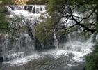
I had a need to go to Smithton yesterday. I took Tastrekkers advice to visit McGowans Falls in summer.
There was a little water in the river. As TT said - very colourful.
McGowans Falls - detail
GETTING THERE:
Pass the Weather Radar at West Takone on the right.
Turn Left here - continuation of Farquhars Road.
Turn right here into Relapse Creek Road.
About another 2 kms from the start of Relapse Creek Rd to the start of the track .
A 10 of 15 minute to the top of the falls on a well made well marked track.
A large tree has fallen across the track about half way which needs negotiating.
The walk down to the falls is fairly straightforward. Not much sign of erosion Tastrekker.
One tricky bit. Need to use the tree roots as a ladder.
One of the great short walks. Will be back after rain!
Gerry
There was a little water in the river. As TT said - very colourful.
McGowans Falls - detail
- McGowans Falls
- MCGOWANS_4380.jpg (173.72 KiB) Viewed 7302 times
GETTING THERE:
Pass the Weather Radar at West Takone on the right.
- West Takone radar
- MCGOWANS_4456.jpg (67.05 KiB) Viewed 7303 times
Turn Left here - continuation of Farquhars Road.
- MCGOWANS_4453.jpg (24.02 KiB) Viewed 7303 times
- MCGOWANS_4447.jpg (35.64 KiB) Viewed 7303 times
Turn right here into Relapse Creek Road.
- Start of track
- MCGOWANS_4443.jpg (32.11 KiB) Viewed 7302 times
About another 2 kms from the start of Relapse Creek Rd to the start of the track .
A 10 of 15 minute to the top of the falls on a well made well marked track.
A large tree has fallen across the track about half way which needs negotiating.
The walk down to the falls is fairly straightforward. Not much sign of erosion Tastrekker.
One tricky bit. Need to use the tree roots as a ladder.
One of the great short walks. Will be back after rain!
Gerry
Last edited by GerryDuke on Tue 11 May, 2010 12:22 am, edited 1 time in total.
-
GerryDuke - Athrotaxis cupressoides
- Posts: 403
- Joined: Sun 18 May, 2008 12:04 am
- Location: KINGSTON BEACH, TASMANIA
- ASSOCIATED ORGANISATIONS: Operator of www.TouringTasmania.info web site
- Region: Tasmania
- Gender: Male
Re: How to get to McGowans falls
![]() by GerryDuke » Tue 11 May, 2010 12:13 am
by GerryDuke » Tue 11 May, 2010 12:13 am
Saw a report where the Arthur River was in flood. While up that way I found time to visit Mc Gowans Falls again as well as Philosopher Falls. The track work at Philosopher Falls is fantastic. Will try and find time to post a few pics.
McGowans Falls.
Gerry
McGowans Falls.
- MGGOWANS-FALLS-004.jpg (117.21 KiB) Viewed 6781 times
Gerry
-
GerryDuke - Athrotaxis cupressoides
- Posts: 403
- Joined: Sun 18 May, 2008 12:04 am
- Location: KINGSTON BEACH, TASMANIA
- ASSOCIATED ORGANISATIONS: Operator of www.TouringTasmania.info web site
- Region: Tasmania
- Gender: Male
Re: How to get to McGowans falls
![]() by 50plus » Sun 13 Mar, 2011 10:21 am
by 50plus » Sun 13 Mar, 2011 10:21 am
Great directions to McGowans falls Gerry good for people without the modern tech equipment , fine set of Falls will try to get back when more water
- 50plus
- Nothofagus cunninghamii
- Posts: 1
- Joined: Tue 02 Feb, 2010 9:39 am
- Region: Tasmania
- Gender: Male
15 posts
• Page 1 of 1
Who is online
Users browsing this forum: Google Adsense [Bot] and 48 guests