Hey all,
I am 15 years old, and i have been walking since i was 12, My first walk was Mt. Anne in september 2004, i had snow up over my waist,
I just finished a walk last week, Dad and his mate and me walked into lees paddock, we camped at reg wadley the first night, then up into new pelion hut, We then walked up onto the saddle between paddys nut and the back end of Mt Ossa, We climbed paddys nut but the weather turned foul so we headed back down where we camped at the east end of Lake ayre, The next day we went along the arm river track to look for the aeroplane crash that we think happened in the 70's by what we have heard, we found the crash but are still wondering if anyone knows anything on it?
If anyone knows anything could they please give me a website or a reference where i can get some info...
Plane crash at Pillinger???
Forum rules
Tasmania specific bushwalking discussion. Please avoid publishing details of access to sensitive areas with no tracks.
Tasmania specific bushwalking discussion. Please avoid publishing details of access to sensitive areas with no tracks.
60 posts
• Page 1 of 2 • 1, 2
Plane crash at Pillinger???
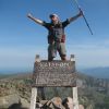
![]() by norto_junior » Fri 14 Sep, 2007 11:12 am
by norto_junior » Fri 14 Sep, 2007 11:12 am
- norto_junior
- Nothofagus cunninghamii

- Posts: 5
- Joined: Fri 14 Sep, 2007 10:50 am
- Location: Germantown, East Coast Tasmania
Re: Plane crash at Pillinger???
![]() by Speculator » Fri 14 Sep, 2007 3:02 pm
by Speculator » Fri 14 Sep, 2007 3:02 pm
norto_junior wrote:Hey all,
I am 15 years old, and i have been walking since i was 12, My first walk was Mt. Anne in september 2004, i had snow up over my waist,
I just finished a walk last week, Dad and his mate and me walked into lees paddock, we camped at reg wadley the first night, then up into new pelion hut, We then walked up onto the saddle between paddys nut and the back end of Mt Ossa, We climbed paddys nut but the weather turned foul so we headed back down where we camped at the east end of Lake ayre, The next day we went along the arm river track to look for the aeroplane crash that we think happened in the 70's by what we have heard, we found the crash but are still wondering if anyone knows anything on it?
If anyone knows anything could they please give me a website or a reference where i can get some info...
I've been interested in this for a while now. I tried to research it a while ago, but there's not much info about to speak of. This site belonging to 'tastrekker' was all I could find.
---
Peak bagging points: 10. Peak bagging bagging points: 10000.
Peak bagging points: 10. Peak bagging bagging points: 10000.
-

Speculator - Optimus Imago

- Posts: 521
- Joined: Fri 15 Jun, 2007 10:35 pm
- Location: Ulverstone
- Region: Tasmania
- norto_junior
- Nothofagus cunninghamii
- Posts: 5
- Joined: Fri 14 Sep, 2007 10:50 am
- Location: Germantown, East Coast Tasmania
![]() by forthferalz » Wed 19 Sep, 2007 9:21 pm
by forthferalz » Wed 19 Sep, 2007 9:21 pm
that's so cool - have you got google map coords or gps coords?
- forthferalz
- Nothofagus gunnii

- Posts: 31
- Joined: Wed 19 Sep, 2007 8:19 pm
![]() by Speculator » Thu 20 Sep, 2007 10:52 am
by Speculator » Thu 20 Sep, 2007 10:52 am
Ooh that's good thinking. I might have to plan a trip in there once I can find some more solid information and see if I can find the wreck and take a waypoint for others' reference.
---
Peak bagging points: 10. Peak bagging bagging points: 10000.
Peak bagging points: 10. Peak bagging bagging points: 10000.
-
Speculator - Optimus Imago
- Posts: 521
- Joined: Fri 15 Jun, 2007 10:35 pm
- Location: Ulverstone
- Region: Tasmania
![]() by forthferalz » Thu 20 Sep, 2007 12:39 pm
by forthferalz » Thu 20 Sep, 2007 12:39 pm
I think that waypoint will have to stay between friends as the wreck seems to have suffered from souvenire hunters. 
Last edited by forthferalz on Thu 20 Sep, 2007 2:09 pm, edited 1 time in total.
- forthferalz
- Nothofagus gunnii
- Posts: 31
- Joined: Wed 19 Sep, 2007 8:19 pm
![]() by Son of a Beach » Thu 20 Sep, 2007 1:51 pm
by Son of a Beach » Thu 20 Sep, 2007 1:51 pm
Now that's an interesting thought... should such sites be preserved, or not?
I've been walking in the Blue Tiers, and stumbling on the large items of old rusty mining equipment is a real feature of the area. Actually looks really good in place. I've been told that Gordonvale's old farming equipment lends the area a bit of charm too (haven't managed to get there yet, myself).
And yet, if the same items were just dropped there yesterday, I would probably think they were rubbish and should be removed immediately.
So what makes it rubbish or not? Is it related purely to how long it has been sitting there? How rusty it is? What it is made of (plastic vs. metal)?
If people pinch bits of the plane wreck, are they doing the environment a favour, or are they depriving other sight seers of a sight to see?
- Son of a Beach
- Lagarostrobos franklinii

- Posts: 7024
- Joined: Thu 01 Mar, 2007 7:55 am
- ASSOCIATED ORGANISATIONS: Bit Map (NIXANZ)
- Region: Tasmania
- Gender: Male
![]() by Joe » Thu 20 Sep, 2007 6:30 pm
by Joe » Thu 20 Sep, 2007 6:30 pm
The blue tier is virtually landfill with all the mining equipment laying around there. I have been told of areas you can visit where items such as boots and hammers etc are still laying around (if you know where to look) I reckon this is great for a look personally but agree...the line between litter and not is interesting. If Gunns <spit> left some of their chain logging gear laying in the forest we would all cry *&%$#! murder....however if you are in the Dip falls area make sure you check out the old forestry boiler that is laying in the bush just out of the car park...its GREAT 
-

Joe - in vino veritas
- Posts: 675
- Joined: Mon 26 Mar, 2007 10:35 pm
- Location: Devonport Tas
- ASSOCIATED ORGANISATIONS: Stoney Creek Outdoor Equipment.
- Region: Tasmania
![]() by Joe » Thu 20 Sep, 2007 6:42 pm
by Joe » Thu 20 Sep, 2007 6:42 pm
forthferalz wrote:I think that waypoint will have to stay between friends as the wreck seems to have suffered from souvenire hunters.
BAH! set the information free I say. The attitude that you cant share special walking spots locations because every man and his dog will go there gives me the irrits. I come across it all too frequently when trying to find info on waterfalls to put on my site. Tassies natural wonders need promoting...not hiding in a closet to be selfishly coveted.
-
Joe - in vino veritas
- Posts: 675
- Joined: Mon 26 Mar, 2007 10:35 pm
- Location: Devonport Tas
- ASSOCIATED ORGANISATIONS: Stoney Creek Outdoor Equipment.
- Region: Tasmania
![]() by gorby » Thu 20 Sep, 2007 6:42 pm
by gorby » Thu 20 Sep, 2007 6:42 pm
the plane crashed in 1973
this is a peice from simon cubits book
the snarers and cattlemen of the mersey high country
I have the co-ordinates of the site somewhere,do I post them or not?

this is a peice from simon cubits book
the snarers and cattlemen of the mersey high country
I have the co-ordinates of the site somewhere,do I post them or not?
-

gorby - Athrotaxis cupressoides

- Posts: 103
- Joined: Thu 20 Sep, 2007 9:24 am
- Location: deloraine
![]() by Joe » Thu 20 Sep, 2007 6:44 pm
by Joe » Thu 20 Sep, 2007 6:44 pm
gorby wrote:the plane crashed in 1973
this is a peice from simon cubits book
the snarers and cattlemen of the mersey high country
I have the co-ordinates of the site somewhere,do I post them or not?
POST EM!
hehe I just realised my 100th post was a rant...those who know me from other forums will be supprised i lasted that long
-
Joe - in vino veritas
- Posts: 675
- Joined: Mon 26 Mar, 2007 10:35 pm
- Location: Devonport Tas
- ASSOCIATED ORGANISATIONS: Stoney Creek Outdoor Equipment.
- Region: Tasmania
![]() by Speculator » Thu 20 Sep, 2007 8:30 pm
by Speculator » Thu 20 Sep, 2007 8:30 pm
gorby wrote:the plane crashed in 1973
this is a peice from simon cubits book
the snarers and cattlemen of the mersey high country
I have the co-ordinates of the site somewhere,do I post them or not?
If you decide not to post them can you PM them to me?
Thanks.
---
Peak bagging points: 10. Peak bagging bagging points: 10000.
Peak bagging points: 10. Peak bagging bagging points: 10000.
-
Speculator - Optimus Imago
- Posts: 521
- Joined: Fri 15 Jun, 2007 10:35 pm
- Location: Ulverstone
- Region: Tasmania
![]() by gorby » Thu 20 Sep, 2007 9:06 pm
by gorby » Thu 20 Sep, 2007 9:06 pm
do these numbers seem right
XXX NNNNNNN
XXX NNNNNNN
push through light scrub off arm track to a mossy clearing and head towards Mt pillinger,look for tapes on trees(blue or orange ) on mersey side and head downhill into trees.
XXX NNNNNNN
XXX NNNNNNN
push through light scrub off arm track to a mossy clearing and head towards Mt pillinger,look for tapes on trees(blue or orange ) on mersey side and head downhill into trees.
EDIT by SOB: Actual numbers removed after discussion with one of the other moderators. Please use private messages for communicating details of access to sensitive areas with no tracks (see the forum rules). I'm not sure how sensitive this area really is, but since it is being debated, I want to err on the side of caution. Sorry for any inconvenience.
-
gorby - Athrotaxis cupressoides
- Posts: 103
- Joined: Thu 20 Sep, 2007 9:24 am
- Location: deloraine
![]() by Son of a Beach » Thu 20 Sep, 2007 9:30 pm
by Son of a Beach » Thu 20 Sep, 2007 9:30 pm
taswaterfalls.com wrote:forthferalz wrote:I think that waypoint will have to stay between friends as the wreck seems to have suffered from souvenire hunters.
BAH! set the information free I say. The attitude that you cant share special walking spots locations because every man and his dog will go there gives me the irrits. I come across it all too frequently when trying to find info on waterfalls to put on my site. Tassies natural wonders need promoting...not hiding in a closet to be selfishly coveted.
heheh... I tend to sway in both directions on this. I think we should make it harder for the marauding hordes to... well... maraude, but should make it easy for the rightful locals to wander and explore at will with ease.
Trouble is, I find it hard to define the difference between the marauding hordes, and the legitimate locals, and to define the difference between marauding and wandering and exploring.
I guess if I'm honest with myself, I just draw the line wherever it suits me best at the time. Not terribly fair, am I? Eg, the legitimate locals, usually means "me and my mates", and the marauding hordes usually means "everybody else".
I often tell people that if I was running this state, I'd charge foreign tourists about 10 times the current parks fees to get anywhere near a park, but charge locals nothing (ie, keep the riff-raff out, and give me easy access, and fewer crowds), and to require foreigners to all be accompanied by a local guide (that's my employment strategy, you see).
As you can see, my policy is designed totally around what suits me, and bollocks to everyone else! Not very economically sound, I'm sure.
Don't think I would ever stand a chance of getting elected (not that I'd want to spend that kind of time the politic elite anyhow).
Last edited by Son of a Beach on Fri 21 Sep, 2007 8:50 am, edited 2 times in total.
- Son of a Beach
- Lagarostrobos franklinii
- Posts: 7024
- Joined: Thu 01 Mar, 2007 7:55 am
- ASSOCIATED ORGANISATIONS: Bit Map (NIXANZ)
- Region: Tasmania
- Gender: Male
![]() by tastrekker » Thu 20 Sep, 2007 10:14 pm
by tastrekker » Thu 20 Sep, 2007 10:14 pm
Hmmm... Interesting discussion.
I think aircraft wrecks in Tassie's wilderness are sufficiently rare for it to be worth attempting to preserve this example.
In my blog, I was deliberately vague about the location. This is mainly because I want to avoid the damage done by unwanted track development in trackless areas of our wilderness.
When I have taken people to the wreck, I have been careful to select routes that will have minimal impact on vegetation. Each time I go a slightly different way. Will everyone who grabs a GPS coordinate from the Internet be as careful?
-

tastrekker - Athrotaxis cupressoides
- Posts: 498
- Joined: Thu 20 Sep, 2007 9:04 pm
- Location: Lenah Valley
- Region: Tasmania
- Gender: Male
![]() by forthferalz » Thu 20 Sep, 2007 10:33 pm
by forthferalz » Thu 20 Sep, 2007 10:33 pm
Actually i wonder if the diagnosis of souveniring is correct after more than a decade - a propeller seems a bit big to want to salvage unless it was a plane of intrinsic significance .
Definitely for me the item is rubbish if it is manmade and toxic or has no significance to the area per se. Old clean mining equipment is harmless as it rusts away and more interesting in situ than in a museum.
Usually i'm not interested in a 2 hour hike to see discarded drink bottles (top of MtRoland!! very dissapointing. ANyone headed up there might like to take some barbeque tongs along and a plastic bag to retrieve a few) but it was useful to find such stuff when we were feeling a bit lost a few times - I was even grateful on one walk to see dog droppings!!!
- forthferalz
- Nothofagus gunnii
- Posts: 31
- Joined: Wed 19 Sep, 2007 8:19 pm
![]() by forthferalz » Fri 21 Sep, 2007 12:08 am
by forthferalz » Fri 21 Sep, 2007 12:08 am
tastrekker wrote:Hmmm... Interesting discussion.
I think aircraft wrecks in Tassie's wilderness are sufficiently rare for it to be worth attempting to preserve this example.
In my blog, I was deliberately vague about the location. This is mainly because I want to avoid the damage done by unwanted track development in trackless areas of our wilderness.
When I have taken people to the wreck, I have been careful to select routes that will have minimal impact on vegetation. Each time I go a slightly different way. Will everyone who grabs a GPS coordinate from the Internet be as careful?
ahh i am such a slooow typer there were all these other posts and one rant i didnt read before my last post above
I think almost everyone has a right to enjoy all of our planet not just the locals. There's certainly a local tinnie and trash element in the marauding hordes i'd like to see go extinct - Also the local greed that uses the wilderness to promote tassie tourism, spends huge amounts on advertisng but neglects to spend "profits" ie taxes properly or has the tourism minister done some maintainence to Mt. Roland tracks which were a disgrace when I visited a year ago? Every parks officer I speak to is always whiinging about budget cuts.
It is very selfish to lock up national parks only for those who can afford a permit but i think it would be equally selfish to not take some care to preserve the 'wilderness' and this may mean needing to control it some extent (there's a time and a place for sharing knowledge - a walk with a guide to initiate one seems a great way to be doing it) Would someone care to organise a walk?
- forthferalz
- Nothofagus gunnii
- Posts: 31
- Joined: Wed 19 Sep, 2007 8:19 pm
![]() by Son of a Beach » Fri 21 Sep, 2007 8:43 am
by Son of a Beach » Fri 21 Sep, 2007 8:43 am
After discussions with another moderator, and in the interest of keeping the peace, so to speak, I'll edit out the coordinates given in the post above.
It could be argued that they are against the forum rules (depending on how sensitive the area is), but in any case they've been sitting there long enough for those of us here to grab them anyhow. If anyone else wants get/give them, please use private messages in the forums, or email.
Now that is a very good suggestion!
on another note...
I do admit that some of my own views on providing open access to all areas, or restricting access by either people-group, or sensitivity, are rather self serving. Therefore I try not to take myself too seriously. I would recommend that nobody else take me too seriously either. In reality, one of the things I enjoy most is taking other people (particularly newbies) into the bush.
It could be argued that they are against the forum rules (depending on how sensitive the area is), but in any case they've been sitting there long enough for those of us here to grab them anyhow. If anyone else wants get/give them, please use private messages in the forums, or email.
forthferalz wrote:(there's a time and a place for sharing knowledge - a walk with a guide to initiate one seems a great way to be doing it) Would someone care to organise a walk?
Now that is a very good suggestion!
on another note...
I do admit that some of my own views on providing open access to all areas, or restricting access by either people-group, or sensitivity, are rather self serving. Therefore I try not to take myself too seriously. I would recommend that nobody else take me too seriously either.
Last edited by Son of a Beach on Tue 16 Oct, 2007 3:13 pm, edited 3 times in total.
- Son of a Beach
- Lagarostrobos franklinii
- Posts: 7024
- Joined: Thu 01 Mar, 2007 7:55 am
- ASSOCIATED ORGANISATIONS: Bit Map (NIXANZ)
- Region: Tasmania
- Gender: Male
![]() by Speculator » Fri 21 Sep, 2007 9:12 am
by Speculator » Fri 21 Sep, 2007 9:12 am
Hmm...
Well, I wasn't going to bother commenting on this, but I think it's time for a reality check.
I really think people are overreacting here a little. The walk to pillinger itself is in quite a remote area, and this wreck isn't exactly a couple of metres from the carpark either. Realistically, how many people are going to drive all the way out there and walk in to look at what is essentially some busted rusting metal in the bush? I mean, we might think it's interesting but I can guarantee most people wont, and if they do the effort outweighs the benefits most of the time.
Like I said, I wasn't going to comment, because I'll walk in there for the views at the mountain which I'm sure will be much more rewarding than the wreck anyway. I don't mind playing devils advocate though either!
l8r.
---
Peak bagging points: 10. Peak bagging bagging points: 10000.
Peak bagging points: 10. Peak bagging bagging points: 10000.
-
Speculator - Optimus Imago
- Posts: 521
- Joined: Fri 15 Jun, 2007 10:35 pm
- Location: Ulverstone
- Region: Tasmania
![]() by gorby » Fri 21 Sep, 2007 11:15 am
by gorby » Fri 21 Sep, 2007 11:15 am
I would think it better to have people knowing where they are going rather than scrub bashing all around the place causing damage to so called sensitive areas.
If anyone wants the grid numbers,please pm me.
I agree that the view from mt pillinger surpasses most other things in the area
If anyone wants the grid numbers,please pm me.
I agree that the view from mt pillinger surpasses most other things in the area
-
gorby - Athrotaxis cupressoides
- Posts: 103
- Joined: Thu 20 Sep, 2007 9:24 am
- Location: deloraine
![]() by forthferalz » Fri 21 Sep, 2007 1:49 pm
by forthferalz » Fri 21 Sep, 2007 1:49 pm
woops that was pretty fast on the edit button - i hadn't saved the post as I'm travelling at the moment. I also need a lesson in using them anyways - so used to just using a GPS and a daggy hand drawn map.
PS Did I hear SOB volunteering to lead the walk?
PS Did I hear SOB volunteering to lead the walk?
- forthferalz
- Nothofagus gunnii
- Posts: 31
- Joined: Wed 19 Sep, 2007 8:19 pm
![]() by Son of a Beach » Fri 21 Sep, 2007 2:14 pm
by Son of a Beach » Fri 21 Sep, 2007 2:14 pm
forthferalz wrote:Did I hear SOB volunteering to lead the walk?
I think not.
Last time I went up Pillinger I was about 12 years old, I think (with a "Boots 'n' All" group). I'm not even sure if it was Pillinger, but it's the only mountain that fits my vague memory of it (at the time, I was convinced I'd been up Pelion West, but years later I realised that's a rather unlikely destination for a day walk for a small 12 year old, after spending the night at the Arm River forestry centre; years later, when I did the Arm River Track, the first part looked very familiar).
The nearest I've been since, is the Arm River track, and although I think I know where the Pillinger track forks off from there, I wouldn't place bets on it.
Besides, I don't have a GPS.
But I'd sure be keen to tag along with somebody who does know the way. Now that gorby has kindly offered the coordinates to those who want them, it will be easier, anyhow.
- Son of a Beach
- Lagarostrobos franklinii
- Posts: 7024
- Joined: Thu 01 Mar, 2007 7:55 am
- ASSOCIATED ORGANISATIONS: Bit Map (NIXANZ)
- Region: Tasmania
- Gender: Male
Plane Crash at pillinger
![]() by norts » Fri 21 Sep, 2007 6:57 pm
by norts » Fri 21 Sep, 2007 6:57 pm
The site is easy to find and the track in is quite distinct.
There is signs of vandalism. PPL have scratched their name into the fusilage.
The interesting thing about going to the site was that on the night before, we were camped at lake Ayr and 2 walkers (on their way to Pelion Hut) stopped for a chat. They had spent 3 hours looking for the site.
We gave them the co-ords and next day while we were their they arrived.
As to publishing or not cor-ordinates, I was worried when John Chapman published Solitary Huts position. It will be interesting to see if the hut will be vandalised.
Both Lees Hut and Reg Wadley do not seem to have suffered from their location being general knowledge.
I think I might have a foot in both camps after re-reading the above.
Roger
-
norts - Lagarostrobos franklinii
- Posts: 2013
- Joined: Wed 01 Aug, 2007 10:45 am
- Location: Germantown Tas.
- Region: Tasmania
![]() by tastrekker » Fri 21 Sep, 2007 8:05 pm
by tastrekker » Fri 21 Sep, 2007 8:05 pm
Today I have been chatting with the senior PWS Ranger responsible for the Central Plateau. His area also covers the Pillinger, Oakleigh, February Plains area.
He confirmed that there appear to be a fairly large number heading into the wreck and quite a well-defined pad has formed.
As for the souvenier collecting, I think a lot of this happened soon after the accident. It was a Latrobe Boys Brigade (BB) trip that was waiting for their food drop. Some BB officers were from Latrobe Auto Wreckers which is etched into the fuselage. In the early years following the wreck, it was a regular destination for BB bushwalks.
-
tastrekker - Athrotaxis cupressoides
- Posts: 498
- Joined: Thu 20 Sep, 2007 9:04 pm
- Location: Lenah Valley
- Region: Tasmania
- Gender: Male
![]() by gorby » Fri 21 Sep, 2007 10:11 pm
by gorby » Fri 21 Sep, 2007 10:11 pm
As a longtime user of lewis's hut with his family,I can tell you that there was quite a bit of sensless damage done to the hut and facilities.It was when a government funded group used to take wayward urban kids up there.When it went beyond a joke( an axe was used to break everything up including the rear door)they were contacted and didn't know it was private propertey.Since then they have camped in other places and the hut and contents seems to have been respected.
-
gorby - Athrotaxis cupressoides
- Posts: 103
- Joined: Thu 20 Sep, 2007 9:24 am
- Location: deloraine
Re: Plane crash at Pillinger???
![]() by tasadam » Sat 15 Dec, 2007 4:13 pm
by tasadam » Sat 15 Dec, 2007 4:13 pm
Would someone like to PM me co-ords and info on how to find it?
Cheers!
Cheers!
-
tasadam - Magnus administratio

- Posts: 5940
- Joined: Tue 10 Apr, 2007 6:58 pm
- Location: Near Devonport, Tasmania
- ASSOCIATED ORGANISATIONS: TasmaniART, Smitten Merino, Macpac
- Region: Tasmania
- Gender: Male
Re: Plane crash at Pillinger???
![]() by MJD » Mon 23 Jun, 2008 9:03 pm
by MJD » Mon 23 Jun, 2008 9:03 pm
Found the wreck the other day. I'd been talking to someone at the New Pelion Hut about the wreck and had noticed a pad heading off from the Arm River track. Followed it down the hill, across a clearing, and down the hill again. I was about to give up when lo and behold... what a surprise.
Carpe diem
-

MJD - Athrotaxis selaginoides

- Posts: 1023
- Joined: Mon 26 May, 2008 11:24 pm
- Region: Tasmania
Re: Plane crash at Pillinger???
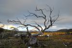
![]() by MJD » Mon 23 Jun, 2008 9:05 pm
by MJD » Mon 23 Jun, 2008 9:05 pm
apologies if you didn't want the picture in this forum.
Carpe diem
-
MJD - Athrotaxis selaginoides
- Posts: 1023
- Joined: Mon 26 May, 2008 11:24 pm
- Region: Tasmania
Transport Then & Now
![]() by E.G. » Tue 24 Jun, 2008 8:03 am
by E.G. » Tue 24 Jun, 2008 8:03 am
By some quirk of fate this plane lies near to the 1890 railway survey between Mole Creek & Zeehan. That and the lovely forest are much more interesting than scrap aluminium.
-

E.G. - Nothofagus gunnii
- Posts: 47
- Joined: Fri 09 May, 2008 5:56 pm
- Region: Tasmania
Re: Plane crash at Pillinger???
![]() by MJD » Tue 24 Jun, 2008 9:10 pm
by MJD » Tue 24 Jun, 2008 9:10 pm
E.G. - You are right, it is a nice forest. Intersting snippet about the railway survey. They must have had fun trying to find the best route for that. I was just having a look on MemoryMap at the terrain they were trying to cover.
Carpe diem
-
MJD - Athrotaxis selaginoides
- Posts: 1023
- Joined: Mon 26 May, 2008 11:24 pm
- Region: Tasmania
60 posts
• Page 1 of 2 • 1, 2
Who is online
Users browsing this forum: No registered users and 30 guests