Page 1 of 1
Access to Mt Pearse
Posted: Sun 06 Sep, 2009 1:30 pm
by Steve
How does one access Mt Pearse? I was down the way a few weeks ago poking around and from what I could tell all the roads coming off the highway (from the Murchison Highway turnoff to the Cradle Mountain turn off) were either dead ends or were gated off. Do you need a key or is there another way in?
Re: Access to Mt Pearse
Posted: Tue 08 Sep, 2009 12:50 pm
by jose
I went there in 2004 from Stafford Road (just over 61k past the Fingerpost). We started walking on a broad moss covered road and then had to find our own way through fairly thick myrtle forest for a bit and came out into bauera and from there we had reasonable view of our destination. It is another mountain where the trig point was just cut off about 40cm above its cement base and tossed to the side, leaving the potential hazard of the iron bars still protruding.
It is a lovely mountain, well worth visiting. It is similar to St Valentines Peak at the top and has great views of the mountains from St Valentines Pk down through the Cradle Mt area, Perrins Bluff, Eldon Range, Mts Reid, Dundas, Zeehan, Agnew and Heemskirk.
Re: Access to Mt Pearse
Posted: Wed 09 Sep, 2009 7:44 pm
by Steve
Sounds good, thanks for the intel!

Re: Access to Mt Pearse
Posted: Sun 08 Aug, 2010 8:21 pm
by Bap
Do anyone have anymore detailed info on this (walking routes)? I tried and failed to climb this on Saturday as I ran out of time because every way I took ended in deep deep Donga. Maybe I'll try again next weekend.
Also would a traverse across to Rocky S.L be possibe or is the Bauera to heavy?
Re: Access to Mt Pearse
Posted: Wed 26 Sep, 2012 9:40 pm
by Tortoise
Any update on this? Ta
Re: Access to Mt Pearse
Posted: Thu 27 Sep, 2012 12:40 pm
by stu
We did this little range a few months ago.
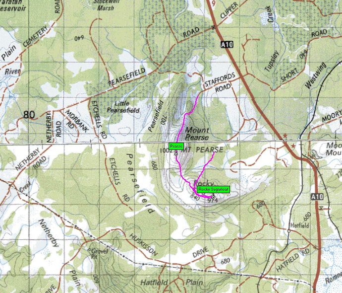
The attached map should be pretty obvious...we started up Pearse, for which there is a tagged track to the top & continued on to Rocky SL (off track).

- Pearse track
- Pearse-RockySL.jpg (359.08 KiB) Viewed 6172 times

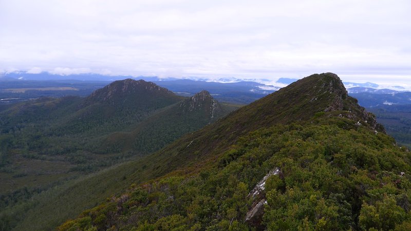
- Looking toward the summit of Mt Pearse & Rocky SL in the distance.
Re: Access to Mt Pearse
Posted: Fri 28 Sep, 2012 9:27 pm
by mjdalessa
Does anyone know anything about the fabled track up Rocky SL?
Re: Access to Mt Pearse
Posted: Fri 28 Sep, 2012 9:40 pm
by Tortoise
stu wrote:We did this little range a few months ago.
The attached map should be pretty obvious...we started up Pearse, for which there is a tagged track to the top & continued on to Rocky SL (off track).
Thanks, Stu. Excellent

Re: Access to Mt Pearse
Posted: Tue 05 Feb, 2013 10:12 am
by Taurë-rana
Just posted a trip report here but then decided it should go in trip reports!
We went up yesterday, access was along Staffords road then up a tagged pad to the summit. It took us 2 and a half hours to reach the summit, and another 6 to get back to the car, but that is another story. It's a good walk with excellent views and the pad is easy to follow until part way along the top of the range to the summit, but you can see your way from there. If you are thinking about going on to Rocky SL and back to your car via the logging roads, talk to someone who has done it before you go, allow yourself a long day and be ok with scrub!
Re: Access to Mt Pearse
Posted: Fri 08 Feb, 2013 2:04 pm
by Zepol
Could you do a few of the peaks along Murchison highway in one day or is it best to split it up?
Re: Access to Mt Pearse
Posted: Fri 08 Feb, 2013 9:46 pm
by Tortoise
Depends how fast you go up & down mountains! 'A few' sounds pretty ambitious, but the mountain leapers might manage it.
Re: Access to Mt Pearse
Posted: Mon 27 Oct, 2014 4:24 pm
by rohjoe
I was part of a small group which visited Rocky SL and Mt Pearse on Saturday. We decided to climb them separately, instead of doing a traverse. It was a very enjoyable day.
To access Rocky we drove a short distance along Mountain Rd (road starts about half km NW of the railway overpass) and parked at a large fallen tree blocking the road. From there it took us 1 hr 45 min to reach the summit. There were a few tags from where we left Mountain Rd which led along old logging tracks to a short band of forest, which opened onto a button grass plain. After following open leads to the ridge there is about 400 metres of reasonably thick scrub just prior to the summit.
I can confirm the earlier comment that there is a very well tagged route to Mt Pearse from the end of Staffords Rd. There is a gate near the start of Staffords Rd which was closed but not locked. We were able drive almost to the end of the road in a non-4wd car. The pad initially passes through pleasant forest, then low scrub and bauera before climbing the steep rocky ridge. The stumps from the old trig are indeed a safety hazard. One of our party lost his balance on the summit and tumbled onto his back but fortunately missed hitting one of the spikes. It took us 1 hr 30 min to the Mt Pearse summit from where we parked.
It’s a quite impressive ridge line on the approach to the summit. The topography/geology around these mountains looks very interesting and a distinct pattern is evident in aerial photos showing a separate ridge which parallels the main ridge on the western side of Mt Pearse.
So, doing these two peaks separately may not save a huge amount of time compared to a traverse but it possibly provides a bit more certainty about the walking conditions.

Cheers,
Rohan

