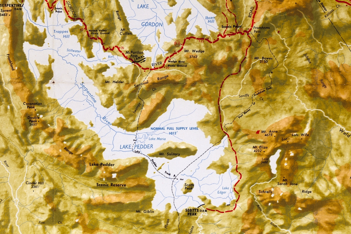
First up, I want to establish where the Scotts Peak track started. My Old River Tasmap (below) shows the situation in 1979, after the flooding. When answering, please use grid references if possible. e.g X is at (396, 347).
Q1: McKays Track coming in from the Western Arthurs – anyone know the history of that track?
Q2: I have a photo taken from point "X" in early 1972, looking NW, showing a group of walkers on their way to Pedder who had come from the Western Arthurs (see below). But was "X" the start of the Scotts Peak track for people who had driven down the Scotts Peak Rd?
Q3: I have another photo of the same group on the Huon Plains (see below), but at location "Y", two kms NE of "X". The photo looks towards Spot Height 826, Frankland Range, and Scotts Peak (cut off, right). I assume it was taken on the way out, indicating the Scotts Peak track was where I had assumed it to be -- starting from somewhere close to the Scotts Peak dam, clipping Scotts Peak and then straight to Lake Pedder. Is the white arrow in the map above roughly the location of the Scotts Peak track?
The reason I'm asking all this is because of the lady who took the photos of the Easter 1972 trip. She says they drove to Scotts Peak, got out and started walking...
... and after some time came across a Hydro hut where they stayed the night and played cards...
I have quite a number of photos taken from the Scotts Peak track. None show a hut on the track. Of the dozens of people whose slides I've scanned, no one else has mentioned a hut on the track. I suspect the hut was quite close to the dam works and that my lady friend is mistaken.
Q4: Any sleuths like to comment on the most likely scenario at the start of the Easter 1972 trip? A group of 6 adults and 7 children, arriving at Scotts Peak at around 2PM on Maundy Thursday, after a six hour drive from Devonport...
• Do they see a hut near the dam site and stay there, starting out the next day? Or...
• Do they start walking straight away, come across a hut somewhere down the track, and decide to stay the night? But why would the Hydro have a hut on the Huon Plains?
I attended a literary debate once, on the subject: "All interesting history is fiction". I consider the affirmative side to have won the debate. In Journeys To Pedder I'm trying to spin interesting stories, and I tell all contributors their stories don't necessarily have to be 100% factual, but they do have to be unfalsifiable so they can't be disputed.