I notice that there is a discrepency in the placement of this hut when comparing The Chapman / Siseman map (page 161 in 5th ed Cradle mtn lake st clair & walls of jerusalem guide book) with the Tasmap 1:25,000 and 1:100,000 maps.
My query to all you history buffs and hut baggers is this:
Is this just the innacuracy of the guide book mud map (/tasmap map) or was there (at some point in time) in fact two separate huts?
just wonderin....
Lake Nameless / Ironstone Hut Clarification
Forum rules
Tasmania specific bushwalking discussion. Please avoid publishing details of access to sensitive areas with no tracks.
Tasmania specific bushwalking discussion. Please avoid publishing details of access to sensitive areas with no tracks.
5 posts
• Page 1 of 1
Lake Nameless / Ironstone Hut Clarification
![]() by Liamy77 » Sun 05 Sep, 2010 4:49 pm
by Liamy77 » Sun 05 Sep, 2010 4:49 pm
- Attachments
-
- comparison of hut locations...
- Ironstone Hut.jpg (217.58 KiB) Viewed 1941 times
Taggunnah
GRAVITY... IS A HARSH MISTRESS!
knowledge's lighter than gadgets..but gadgets can be fun!
GRAVITY... IS A HARSH MISTRESS!
knowledge's lighter than gadgets..but gadgets can be fun!
-
Liamy77 - Auctorita modica

- Posts: 1593
- Joined: Tue 20 Apr, 2010 4:36 pm
- Location: Southern Channel, Tas.... but sometimes i leave n walk around elsewhere!
- ASSOCIATED ORGANISATIONS: Woodbridge Organics
- Region: Tasmania
- Gender: Male
Re: Lake Nameless / Ironstone Hut Clarification
![]() by flyfisher » Sun 05 Sep, 2010 6:33 pm
by flyfisher » Sun 05 Sep, 2010 6:33 pm
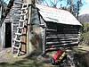
The old hut was definitely in the position shown by Tasmap.
I was out there around 30 years ago and it wasn't much of a hut then, but thats where it was.
ff
I was out there around 30 years ago and it wasn't much of a hut then, but thats where it was.
ff
If you don't know what I'm talking about, then you need to drink more.
-
flyfisher - Athrotaxis selaginoides

- Posts: 1532
- Joined: Sat 14 Jul, 2007 8:39 pm
- Location: hobart
- ASSOCIATED ORGANISATIONS: landrover owners club of tasmania
- Region: Tasmania
Re: Lake Nameless / Ironstone Hut Clarification
![]() by taswegian » Sun 05 Sep, 2010 6:59 pm
by taswegian » Sun 05 Sep, 2010 6:59 pm
I have been there a few times and don't remember any sign of remains of a hut on west side lake. (I stand correcting though)
The new hut was rebuilt over the old one or the old one was just remodelled.
Its defenitely on south side of Lake and the loo is just along the track to southeast.
The 'Chapman' site was where we spent one of my most memorable nights out in a tent.
The day was one of those 'all seasons in on day' events and we had hail, snow and a violent thunder storm after quite a nice day.
I was very aware of the aluminium poles sticking up into the night sky as each flash lit up the night sky.
We woke to a quiet morning of snow and no wind - very peaceful.
-

taswegian - Phyllocladus aspleniifolius

- Posts: 889
- Joined: Tue 27 Jul, 2010 8:34 pm
- Region: Tasmania
- Gender: Male
Re: Lake Nameless / Ironstone Hut Clarification
![]() by corvus » Sun 05 Sep, 2010 7:06 pm
by corvus » Sun 05 Sep, 2010 7:06 pm
Tasmap is correct you can pick the Hut up clearly on Google Earth in that position.
collige virgo rosas
-

corvus - Vercundus gearus-freakius

- Posts: 5538
- Joined: Mon 23 Apr, 2007 7:24 pm
- Location: Devonport
- Region: Tasmania
- Gender: Male
Re: Lake Nameless / Ironstone Hut Clarification
![]() by Liamy77 » Sun 05 Sep, 2010 10:19 pm
by Liamy77 » Sun 05 Sep, 2010 10:19 pm
thankyou... the two names got me wondering!
Taggunnah
GRAVITY... IS A HARSH MISTRESS!
knowledge's lighter than gadgets..but gadgets can be fun!
GRAVITY... IS A HARSH MISTRESS!
knowledge's lighter than gadgets..but gadgets can be fun!
-
Liamy77 - Auctorita modica
- Posts: 1593
- Joined: Tue 20 Apr, 2010 4:36 pm
- Location: Southern Channel, Tas.... but sometimes i leave n walk around elsewhere!
- ASSOCIATED ORGANISATIONS: Woodbridge Organics
- Region: Tasmania
- Gender: Male
5 posts
• Page 1 of 1
Who is online
Users browsing this forum: No registered users and 13 guests