Tarkine

Tasmania specific bushwalking discussion.
Forum rules
Tasmania specific bushwalking discussion. Please avoid publishing details of access to sensitive areas with no tracks.

Re: Tarkine

Postby GerryDuke » Fri 06 Feb, 2009 10:56 pm

Thanks MrCamel for the research. For those who don't have time to read the minutes the key drift of the Tarkine Drive proposal are as follows:

Take from Circular Head Council MEETING 15th MAY 2008

"The Tarkine Drive proposal involves the construction of:-

a 127km bitumen road from the present southern terminus of the sealed pavement of
Myalla Road through to the to the Arthur River township on the West Coast;

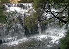
a short 5km spur road to key ‘iconic’ attractions – Tarkine Lookout and Tarkine Falls;

nature trails, visitor facilities and forest interpretation at Phantom Valley;

upgrades at Lake Chisholm and Julius Forest Reserves and Sumac Lookout;

visitor facilities and amenity services, pull-overs, a number of short trails and
interpretation."

There is a map of the proposed route but with little detail:

TARKINE-DRIVE.jpg


It looks as if the road would cross the Arthur River at the location where Hilder Bridge was at the southern end of the Keith River Road. The road passes the Detention Falls turnoff - another short diversion on the "Tarkine Drive". Great Falls on a newly re-constructed track and viewing platform (a few years ago now!). From Hilder Bridge it looks to to follow Lyons Road (falling into the River as noted by Tastrekker) and over to the existing Tayatea Road (no where near the washed away bridge). The 'new' road from the hilder crossing to Tayatea Road does not look very far! If it means the sealing of the existing roads right through to Arthur River then it can only be a good thing! A lot has alredy been done along the route. A few kilometres of the road near Julius River has been sealed (from the river to the new very rough camping area. A new short track has been put in adjacent ot the existing track at the Julius River Reserve.

The coast line north and south of Couta Rocks (and beyond of course) is superb - If you haven't been there, visit Sarah Anne Rocks! A great 45 minute walk to Couta Rocks. The road in could do with sealing!

There is also no detail on the 643 hectares of new reserves along the road. I think one of the real problems perhaps most Tasmanian's have is the clearfelling right up to the road on main (and potential) tourist routes. Eg Old Murchison Hwy each side of the Hellyer Gorge, The Sideling, Weldborough Pass and other parts of the Blue Tier, Bass Hwy east of Paramatta Creek, the list goes on (can anyone add any more?). So if the areas south of Hilder crossing in and around the road are proteced then it is a good thing - but the push needs to go on for more!! There are also caves in the Lyons River area. Has anone more information on these!!
Last edited by GerryDuke on Mon 09 Feb, 2009 10:55 pm, edited 2 times in total.
User avatar
GerryDuke
Athrotaxis cupressoides
 
Posts: 403
Joined: Sun 18 May, 2008 12:04 am
Location: KINGSTON BEACH, TASMANIA
ASSOCIATED ORGANISATIONS: Operator of www.TouringTasmania.info web site
Region: Tasmania
Gender: Male

Re: Tarkine

Postby tastrekker » Sun 08 Feb, 2009 8:54 pm

tasadam wrote:But my personal observations are such that the whole Tarkine area needs a decent management / co-operation approach.

If you have not already done so, download the Cradle Coast Authority (CCA) "Tarkine Tourism Development Strategy October 2008" I've had a good look at the document and I can't say there is anything much in there that I disagree with. The big thing to note is that it does not support the link road.

Back when the report was released, Circular Head Council threatened to withdraw from the society over this omission and I vaguely remember the CCA retreated and proposed a modified route which I think was essentially a sealing of the existing South Arthur Forest Drive. Someone else may be able to recall this more clearly and/or be able to pull up relevant newspaper articles. Someone may even take the time to check this with the CCA to get it from the horse's mouth so to speak.

The report suggests Waratah, Corinna and Arthur River (township by the river mouth) be the main gateways to the region. It lists the 'phantom valley' area near Hilders Bridge as a possible 4th minor gateway to the region. I would also add West Takone as another minor gateway due to McGowans Falls and Victory Springs in that area.

The greatest thing missing from the report in my mind is national park status. I dealt with this issue a little in my previous post. The lack of strong reserve status leaves 95% open to mining. Also, there are still big areas of significant old growth forests available with absolutely no protection from large scale tree felling.

Again, I strongly urge people to look at this document and contemplate whether the suggested strategy is a good way to manage the region.
User avatar
tastrekker
Athrotaxis cupressoides
 
Posts: 498
Joined: Thu 20 Sep, 2007 9:04 pm
Location: Lenah Valley
Region: Tasmania
Gender: Male

Re: Tarkine

Postby tastrekker » Sun 08 Feb, 2009 9:19 pm

GerryDuke wrote:From Hilder Bridge it looks to to follow Lyons Road (falling into the River as noted by Tastrekker) and over to the existing Tayatea Road (no where near the washed away bridge). The 'new' road from the hilder crossing to Tayatea Road does not look very far! If it means the sealing of the existing roads right through to Arthur River then it can only be a good thing! A lot has alredy been done along the route. A few kilometres of the road near Julius River has been sealed (from the river to the new very rough camping area. A new short track has been put in adjacent ot the existing track at the Julius River Reserve.

I have been fascinated by the proposed route and I still find myself a little torn about whether it is appropriate.

Apart from the short section from Hilders crossing to Tayetea Road south of the Milkshakes, it essentially involes sealing the South Arthur Forest Drive. My immediate reaction to this is surely you would start by sealing the South Arthur Forest Drive (SAFD) and see how poopular that is.

A big problem with the SAFD and the new proposed road is the huge amount of logging activity along the way. I am sure Forestry Tas plan to minimise this with buffer zones, etc so improve the visual amenity but most tourists are aware that what they are looking at is only skin deep.

This problem affects all the features along this drive. Milkshakes, Lake Chisolm, Julius River, Sumac Lookout. They are all islands floundering in a sea of logging activity. In a way, this is part of Tassie's European industrial and cultural landscape and something that I believe will change but will not change overnight. There are plenty of places in Tassie where tourists are exposed to a patchwork of European influence.

The road that I am much more interested in is the Western Explorer. It is already there. That battle has been and gone. It is terribly tedious through the buttongrass sections but this is part of the beauty. I wonder how much re-engineering would be required to speed up this section. The Western Explorer traverses just as much rainforest, etc as the proposed loop road. If it is accessed via the coast from Marrawah, it goes through a relatively small amount of forestry activity.

None of the maps I have seen propose where the branch road to Tarkine Falls and the lookout would go. I reckon it would come in from the North West rather than along the Folly Hill Road route used by bushwalkers. It would be great to hear from anyone who can get some inside information to confirm this route.

While Tarkine Falls are spectacular, they are quite similar to Dip Falls. In fact, I'm fairly certain Dip Falls would be bigger in terms of both stream size, height and width. Benefits of Tarkine Falls over Dip Falls is the lack of developed path and viewing platform and the lack of nearby logging activity. The proposed branch road will change these benefits. Even if the new road goes ahead, Tarkine Falls and the cascades further downstream should be left for bushwalkers who are up to at least a half to full day walk. The 'nature trail tourist' visiting this area is already well catered for at Dip Falls and Detention Falls.
User avatar
tastrekker
Athrotaxis cupressoides
 
Posts: 498
Joined: Thu 20 Sep, 2007 9:04 pm
Location: Lenah Valley
Region: Tasmania
Gender: Male

Re: Tarkine

Postby GerryDuke » Mon 09 Feb, 2009 1:09 am

Thanks Tastrekker. Plenty to think about. Bearing in mind that it took 200 years and a very tragic accident to see the sealing of the Dove Lake road. At least things are now moving in the right direction as opposed to the lack of under Lennon and Gray! I thought of raising 2 forum topics. The first being a wish list of access roads we might like to see better developed. Eg The Mersey Forest Road, Eddystone Point etc. Another topic might be Tourist Corridors that could have been better protected from clearfelling "eyesores" - A multitude of areas in the North Eastern Forests, The Bass Hwy east of Parramatta Creek!, The Sideling, each side of the Hellyer Gorge etc.

I worked with some power players around the Bacon Government. It was clear that most did not have any idea of what is there that ought to be protected. One Sawmill owner did not realize the long term wiping out of Tasmania's ornate timbers by clearfelling. The authors in this forum have a very detailed knowlege collectively - some like Tastrekker far mor than others. I only started bushwalking 6 years ago and I am astounded by the "save the 45% in reserves and trash the rest" approach.

Your comments about mining are disturbing!! As I have mentioned in the past - it is what we are not being told is of concern. Eg the wood supply agreement. Again it sounds like the Hydro of the 60's in supplying heavy industry at "wholesale" rates - What if we run out of water!! What if a large proportion of the plantations are destroyed by fire or disease. Will the Pulp Mill receive priority over saw mills?
User avatar
GerryDuke
Athrotaxis cupressoides
 
Posts: 403
Joined: Sun 18 May, 2008 12:04 am
Location: KINGSTON BEACH, TASMANIA
ASSOCIATED ORGANISATIONS: Operator of www.TouringTasmania.info web site
Region: Tasmania
Gender: Male

Re: Tarkine

Postby prankphonecall » Thu 12 Feb, 2009 2:01 pm

Ahhh... the trusty rola! I've taken my rola many places it shouldn't have been!

Reading your story i couldn't help but have a vision of a targa tasmania stage... flying down a closed road in a rola! What could be more fun!
User avatar
prankphonecall
Nothofagus gunnii
Nothofagus gunnii
 
Posts: 35
Joined: Fri 16 Jan, 2009 8:13 am
Location: Brisbane, QLD

Re: Tarkine

Postby MrCAMEL » Wed 18 Feb, 2009 10:24 am

I went into the local FT office last Thursday to find out more. (I was sure, thought I was sure that a road proposed by FT was the one that had been said yes too).
I talked to a bloke that I know, a little bit, from elsewhere, so I know he would have got back to me as soon as he had info.

I asked for specifics of the route. He told me they he did not think they had recieved info about the road in that office and he himself was wanting to find out the route and was quite interested in it.
But I have not heard anything for almsot a week.

No wonder people (posted in other topics) have trouble getting info out of the FT as they seem to not even be able to communicate between each other.
Vrilen Snyson Racing: Finding us all a Vrilen
Asparagus: Experience the versatility
User avatar
MrCAMEL
Athrotaxis cupressoides
 
Posts: 104
Joined: Fri 18 Jul, 2008 11:10 pm
Location: Mongol Land
Region: Other Country

Re: Tarkine

Postby Taurë-rana » Sun 22 Feb, 2009 6:25 pm

MrCAMEL wrote: I am sure some of the roads they would plan to upgrade would be in such a bad state that it would effectively be like starting from scrath anyways.

But i'm not sure. A sealed road between Temma and Myalla via the Tarkine Falls would kill all the fun. :(


I reckon MrCamel is right - there are many roads in that area that are no longer passable and in a few years would be very hard to even find. As for killing the fun, I wonder whether the powers that be remember that not everyone prefers a sealed road - gravel roads can be a lot of fun to drive, and whenever we go travelling we search out the back roads because they are often more interesting and scenic.
I do wonder about the government's motive in supporting FT's option when the local bodies are against it.
Peak bagging points: 170ish
Recent walks - Picton, Wylds Crag, Rogoona
User avatar
Taurë-rana
Athrotaxis selaginoides
 
Posts: 1031
Joined: Mon 14 Jan, 2008 8:28 pm
Location: Devonport
Region: Tasmania

Re: Tarkine

Postby flyfisher » Sun 22 Feb, 2009 7:22 pm

Sealed roads are SO good for carting logs on.
Do they really care about tourists? Don't think so otherwise they would have got the western Explorer reopened much quicker than they did. I think Corinna and the Pieman ferry would have really felt the pinch financially. but they don't really matter do they ?
Fancy spending $23,000,000 on an unpopular road when the Lake and Marlborough "highways"still remain dusty roads which have many potholes and corrugations and carry a lot of traffic--many of them tourists.
The road from Lake hwy. to Liaweenie is a total discrace and carries many visiting anglers .Some of the potholes in this section would be 150--200mm deep.
Makes it hard to believe that the new road is just for tourists.
Are they going to replace the washed out bridge over the Arthur river in the near future.
I don't think they have replaced the one near Pioneer in the N.E. over the Ringarooma river yet either.

FF
If you don't know what I'm talking about, then you need to drink more.
User avatar
flyfisher
Athrotaxis selaginoides
 
Posts: 1532
Joined: Sat 14 Jul, 2007 8:39 pm
Location: hobart
ASSOCIATED ORGANISATIONS: landrover owners club of tasmania
Region: Tasmania

Re: Tarkine

Postby flyfisher » Sun 22 Feb, 2009 7:35 pm

i don't want my previous post to be taken as an anti government rant but F.T. seem to have the type of influence over them which the H.E.C. had previously.

FF
If you don't know what I'm talking about, then you need to drink more.
User avatar
flyfisher
Athrotaxis selaginoides
 
Posts: 1532
Joined: Sat 14 Jul, 2007 8:39 pm
Location: hobart
ASSOCIATED ORGANISATIONS: landrover owners club of tasmania
Region: Tasmania

Re: Tarkine

Postby Taurë-rana » Sun 22 Feb, 2009 7:39 pm

Well said FF, I restrained my comments about FT's motivation as I've ranted here before. I think it might be more of a case of Gunns having power over FT though, as we have seen elsewhere, FT often don't seem all that well informed about things.
Peak bagging points: 170ish
Recent walks - Picton, Wylds Crag, Rogoona
User avatar
Taurë-rana
Athrotaxis selaginoides
 
Posts: 1031
Joined: Mon 14 Jan, 2008 8:28 pm
Location: Devonport
Region: Tasmania

Re: Tarkine

Postby Son of a Beach » Mon 23 Feb, 2009 7:42 am

flyfisher wrote:Fancy spending $23,000,000 on an unpopular road when the Lake and Marlborough "highways"still remain dusty roads which have many potholes and corrugations and carry a lot of traffic--many of them tourists.


They fixed the Marlborough Highway problem by downgrading it. It is officially not a highway anymore. Some fix, eh? :roll:
Son of a Beach
Lagarostrobos franklinii
 
Posts: 7024
Joined: Thu 01 Mar, 2007 7:55 am
ASSOCIATED ORGANISATIONS: Bit Map (NIXANZ)
Region: Tasmania
Gender: Male

Re: Tarkine

Postby flyfisher » Mon 23 Feb, 2009 5:53 pm

Doesn't matter what you call it S.O.B. it's still a very busy road during the fishing season at least, and really should be sealed NOW, as should the road from Bronte turnoff to the top of Great lake.
We had a shack at Miena for 22 years and during that time it didnt even get all sealed from Arthurs turnoff to Miena.
Still it keeps windscreen repairers in business. :D

FF
If you don't know what I'm talking about, then you need to drink more.
User avatar
flyfisher
Athrotaxis selaginoides
 
Posts: 1532
Joined: Sat 14 Jul, 2007 8:39 pm
Location: hobart
ASSOCIATED ORGANISATIONS: landrover owners club of tasmania
Region: Tasmania

Re: Tarkine

Postby Son of a Beach » Mon 23 Feb, 2009 6:42 pm

Totally agree, FF. I still call it the Marlborough Highway. I loved the road signs that some of the land owners had up next to the road a while back apologising to all the tourists for the pot holes.
Son of a Beach
Lagarostrobos franklinii
 
Posts: 7024
Joined: Thu 01 Mar, 2007 7:55 am
ASSOCIATED ORGANISATIONS: Bit Map (NIXANZ)
Region: Tasmania
Gender: Male

Re: Tarkine

Postby GerryDuke » Tue 24 Feb, 2009 8:40 pm

I drove the Marlborough Hwy in April last year. It was in very good condition.
User avatar
GerryDuke
Athrotaxis cupressoides
 
Posts: 403
Joined: Sun 18 May, 2008 12:04 am
Location: KINGSTON BEACH, TASMANIA
ASSOCIATED ORGANISATIONS: Operator of www.TouringTasmania.info web site
Region: Tasmania
Gender: Male

Re: Tarkine

Postby MrCAMEL » Tue 10 Mar, 2009 7:25 pm

I decided to ring up a different FT today and see what I could find out.
The fella seemed reluctant to tell me anything. At first I thought all he was going to tell me was that the South Arthur Forest Drive would be sealed.
But when I threw some other road names at him, I got some more info. Although it was very limited.
Like most 'touristy' places, it seems, (he said the road basically runs past plantation coupes) that the tourist site will be promoted, but on one side of the road there will be plantations and logging. Which is the main thing I cannot understand. Why promote something as pristine and beautiful, if just a few metres away there is a great mess? But, it seems people buy it, so good on them.
Go and checkout the view of the Griffin Camping area. Truly amazing :shock: :!:

I asked where the road was going to intersect the pipeline and he said, "well, there are a few options". Which was strange, and he didnt suggest any.
Also, the only thing that seemed to be definite was that the Hilder's Bridge was getting fixed.

This afternoon I found this on a Facebook page, I found what I was looking for.

http://www.facebook.com/ext/share.php?s ... ra&u=09I_5
http://bbs.keyhole.com/ubb/ubbthreads.p ... e=Proposed Forestry Tasmania Tarkine Road.kmz

It's a Google Earth thing and it shows the route (I can only assume it is the route proposed, not something that Mr Jordan has made up to suit himself).

From the South Arthur Forest Drive, it appears to come down the Tayatea Rd, over the Little Rapid River, which from memory is this one,
Image

and from that side of the Pipeline, the roads end, as I found out last November when I was doing a random bush tour.
Image

As you can see there would be a lot of work required, as a fair bit of the road is like that, or this
Image

Then it crosses the Pipeline and joins what Google calls the Singlines Track, onto Folly Hill Road and then Keith River Road.

So, that is all
Vrilen Snyson Racing: Finding us all a Vrilen
Asparagus: Experience the versatility
User avatar
MrCAMEL
Athrotaxis cupressoides
 
Posts: 104
Joined: Fri 18 Jul, 2008 11:10 pm
Location: Mongol Land
Region: Other Country

Re: Tarkine

Postby corvus » Tue 10 Mar, 2009 7:37 pm

MrCamel,
Why not wait for a couple of weeks b4 casting judgment and or asking FT employees for a definite answer ,do you know exactly what your employer is doing on Friday :lol:
c
collige virgo rosas
User avatar
corvus
Vercundus gearus-freakius
 
Posts: 5538
Joined: Mon 23 Apr, 2007 7:24 pm
Location: Devonport
Region: Tasmania
Gender: Male

Re: Tarkine: "What's the point of having it?"

Postby Clownfish » Wed 11 Mar, 2009 3:35 pm

Did anyone else catch David Bartlett's outburst in Parliament, yesterday?

What's the point of having the Tarkine, if you won't let anyone see it?

To me, this statement goes to heart of the whole attitude around wilderness, development, tourism, etc.

What's the point of something, if humans can't "have" it? Should wilderness be allowed to exist for its own sake, or should it only be there for the use and enjoyment of humans?

For myself, I tend to think that wilderness areas are best left largely alone, but very carefully managed; minimising the impact of humans. If that means not building roads, so be it.

Of course, I'm lucky: I'm not exactly fit, but I do have the wherewithal to see some of our wild places on foot. That said, there are places that I may never visit. I'm happy with that. As long as I know they're there, I don't care whether I get to see them or not.

I may never climb Mount Everest, but I'm not going to demand that the Gummint installs an elevator, just so I can.
User avatar
Clownfish
Athrotaxis cupressoides
 
Posts: 161
Joined: Mon 19 Jan, 2009 9:15 am
Location: Meander Valley, Tasmania
Region: Tasmania

Re: Tarkine

Postby GerryDuke » Wed 11 Mar, 2009 7:36 pm

Another dimension to the controversy is the existence of Magnesium Caves in the Lyons - Arthur River area. I don't know how current these links are!

http://209.85.173.132/search?q=cache:db ... cd=4&gl=au

http://www.acfonline.org.au/news.asp?news_id=412
Cave Systems - about 2/3rds of the way down the page!

GD
Last edited by GerryDuke on Wed 11 Mar, 2009 10:18 pm, edited 1 time in total.
User avatar
GerryDuke
Athrotaxis cupressoides
 
Posts: 403
Joined: Sun 18 May, 2008 12:04 am
Location: KINGSTON BEACH, TASMANIA
ASSOCIATED ORGANISATIONS: Operator of www.TouringTasmania.info web site
Region: Tasmania
Gender: Male

Re: Tarkine: "What's the point of having it?"

Postby tastrekker » Wed 11 Mar, 2009 9:37 pm

Premier Bartlett wrote:What's the point of having the Tarkine, if you won't let anyone see it?

Yes. That was embarassing. Sadly it would have to be up there with the "Leech ridden ditch" comments from another premier many moons ago.

People can see the Tarkine now! If you don't mind a bit of gravel, the South Arthur Forest Drive and Western Explorer show everything this proposed road will have to offer. If you prefer to stick with the black-top, the Murchisson Highway, Corrinna and Reece Dam Roads have plenty to offer. These can all be linked up to create circuits.

About the only slight positive I can see about the new road is that it finally puts Circular Head on a sealed tourist loop rather than a dead end. They hoped the Western Explorer would do that but it has never been up to the standard needed to attract mainstream tourists and their hire cars. Dead ends do not need to be terminal though. Port Arthur is a dead end but plenty of visitors make their way down there. In fact, Burnie to Stanley is almost exactly the same time and distance as Sorell to Port Arthur. Since recent upgrades, I would even say the trip through the Sisters Hills is a safer and more pleasant drive than the goat track leading to the peninsulas! I'm off track a touch so I think it must be time to quit...
User avatar
tastrekker
Athrotaxis cupressoides
 
Posts: 498
Joined: Thu 20 Sep, 2007 9:04 pm
Location: Lenah Valley
Region: Tasmania
Gender: Male

Tarkine Road on the Radio

Postby tastrekker » Sat 14 Mar, 2009 7:21 am

Yesterday, Tim Cox used a letter from yours trully to open his Friday forum. His guests were Cassie O'Connor (Greens), Brett Whitely (Libs) and someone from the Labor party.

Unfortunately I missed the discussion so I can't say what the response was - I'm just stoked that Coxie saw fit to air the letter in front of the pollies. Sometimes the Friday Forum is available for pod-cast from here: http://www.abc.net.au/tasmania/features/fridayforum.xml

Here's my letter:

Dear Tim,

The government is driving me nuts over this Tarkine road issue. Yesterday Premier Bartlett said the Liberal & Green approaches are piecemeal. Both Liberal & Green recommendations are based on the strategy prepared by the Cradle Coast Authority. There is nothing piecemeal about that strategy. It is very well and whollistically written, taking into account issues, benefits and opportunities for every council, land administrator and commercial operator potentially involved in the Tarkine region. I have seen nothing from the government to rival that document in their support of the new road. The government are the ones taking a piecemeal and secretive approach.

Today Premier Bartlett reckons the new road could rival the Great Ocean Road in Victoria. How absurd. I have extensively walked and mountain biked the area along the proposed road and there is ABSOLUTELY NOTHING along that road that cannot already be seen from roads elsewhere in the region. The Western Explorer, Reece Dam Road, Corrinna Road and Murchison Highway all pass through terrific examples of what the new road will pass through. If tourists are not flocking in droves to traverse these roads, the new road will add nothing.

I wonder if the government had even read the CCA Tarkine strategy before deciding their position.

Regards,
TasTrekker
User avatar
tastrekker
Athrotaxis cupressoides
 
Posts: 498
Joined: Thu 20 Sep, 2007 9:04 pm
Location: Lenah Valley
Region: Tasmania
Gender: Male

Re: Tarkine

Postby Son of a Beach » Sat 14 Mar, 2009 7:30 am

nice work! :-) well done
Son of a Beach
Lagarostrobos franklinii
 
Posts: 7024
Joined: Thu 01 Mar, 2007 7:55 am
ASSOCIATED ORGANISATIONS: Bit Map (NIXANZ)
Region: Tasmania
Gender: Male

Re: Tarkine

Postby GerryDuke » Sun 15 Mar, 2009 2:17 am

Ditto TT :mrgreen:

Gerry
User avatar
GerryDuke
Athrotaxis cupressoides
 
Posts: 403
Joined: Sun 18 May, 2008 12:04 am
Location: KINGSTON BEACH, TASMANIA
ASSOCIATED ORGANISATIONS: Operator of www.TouringTasmania.info web site
Region: Tasmania
Gender: Male

Re: Tarkine Road on the Radio

Postby PeterJ » Sun 15 Mar, 2009 7:45 pm

tastrekker wrote:Yesterday, Tim Cox used a letter from yours trully to open his Friday forum.......


Good on you Tastrekker
User avatar
PeterJ
Athrotaxis cupressoides
 
Posts: 449
Joined: Mon 24 Sep, 2007 5:06 pm
Location: Lenah Valley
Region: Tasmania
Gender: Male

Re: Tarkine

Postby Taurë-rana » Sun 15 Mar, 2009 7:54 pm

I heard it TT, I like Tim Cox, he's intelligent and a stirrer. I thought your letter was well written, but I can't remember the response (remembering things I hear is not my strong point) except that Cassie O'Connor and Brett Whitely were falling over each other to agree with each other which I couldn't believe, and the brand new young Labor member was floundering. It was entertaining.
I liked your bit about tourists not flocking to the roads already here which are as scenic as the one proposed - the new route from Tullah to Queenstown via Lake Plimsoll is absolutely stunning but I haven't heard it promoted as a tourist drive. I also find it interesting that people think that one of the problems with the logging is that it can be seen from the road, where I think that a major problem with the logging is that most of it is hidden and people just have no idea of its extent.
Peak bagging points: 170ish
Recent walks - Picton, Wylds Crag, Rogoona
User avatar
Taurë-rana
Athrotaxis selaginoides
 
Posts: 1031
Joined: Mon 14 Jan, 2008 8:28 pm
Location: Devonport
Region: Tasmania

Re: Tarkine

Postby tasadam » Thu 16 Apr, 2009 8:09 am

I just heard on the radio that there was an email released under freedom of info laws, and on the radio they claimed (if I heard correctly) that Forestry Tas didn't want a Federal environmental assessment of the Tarkine road.
The only thing I can find on the net about it is this -
http://www.abc.net.au/news/stories/2009 ... 544020.htm
User avatar
tasadam
Magnus administratio
 
Posts: 5940
Joined: Tue 10 Apr, 2007 6:58 pm
Location: Near Devonport, Tasmania
ASSOCIATED ORGANISATIONS: TasmaniART, Smitten Merino, Macpac
Region: Tasmania
Gender: Male

Re: Tarkine

Postby billshep » Mon 20 Apr, 2009 9:03 am

Re Tarkine ,Corinna and camping. I have been in there a couple of times this summer and found Corinna a great access point for camping and kayaking. I didn't ask, I just explored! There are good short tracks to the Whyte and Savage rivers where you can camp in beautiful open rain forest. There is an excellent new track up Mt Donaldson from the Savage bridge, although the fire damage is extensive on the higher slopes. The kayak gives even better access to camping along the rivers, just watch for the tide as you can end up loading over muddy logs if you get it wrong!
I think that better roads and more tourists will help counter the prevailing culture of 4 wd and trail biking in parts of the area. It would be a pity if access was only linked to expensive private tours.
cheers, Bill
billshep
Nothofagus gunnii
Nothofagus gunnii
 
Posts: 44
Joined: Thu 11 Sep, 2008 11:38 pm
Region: Tasmania

Re: Tarkine

Postby noodle » Mon 20 Apr, 2009 3:45 pm

tastrekker wrote:
Apart from the short section from Hilders crossing to Tayetea Road south of the Milkshakes, it essentially involes sealing the South Arthur Forest Drive. My immediate reaction to this is surely you would start by sealing the South Arthur Forest Drive (SAFD) and see how poopular that is.

A big problem with the SAFD and the new proposed road is the huge amount of logging activity along the way. I am sure Forestry Tas plan to minimise this with buffer zones, etc so improve the visual amenity but most tourists are aware that what they are looking at is only skin deep.

This problem affects all the features along this drive. Milkshakes, Lake Chisolm, Julius River, Sumac Lookout. They are all islands floundering in a sea of logging activity. In a way, this is part of Tassie's European industrial and cultural landscape and something that I believe will change but will not change overnight. There are plenty of places in Tassie where tourists are exposed to a patchwork of European influence.

[/quote]

I agree.
There is a lot of tourist attractions packed into a nice size bit of land. They should atleast reconstruct the Tayatea bridge.
There is nothing worse then having to drive the SAFD from the Kannunah bridge end all the way to the milkshakes (which is probably only 5 kms from Tayatea) and then have to drive all the way back along the same bad gravel road which is blown out from log truck use.

There is also Beckett Falls and other lookouts in that section also.

There are plenty of oppurtunities for tourists to use this area but they are put off by the bad gravels roads and having to back track such a large distant which should be a priority to be fixed (this is what tourists in the area have actually said).

There is also the fact that the road in its current state isn't fully accessible in winter.
There is not much that can be down till next summer now, but it is suprising it has not been sorted sooner.
noodle
Nothofagus cunninghamii
 
Posts: 1
Joined: Mon 20 Apr, 2009 2:54 pm
Region: Tasmania

Re: Tarkine

Postby luke_vic » Wed 13 May, 2009 8:16 pm

I was just watching the 7:30 report when I saw David Bartlett talking about tourism development in the Tarkine. This guy has no idea! Hopefully his grand tourism plans get knocked on the head.
luke_vic
Atherosperma moschatum
 
Posts: 79
Joined: Mon 18 Aug, 2008 6:38 pm

Re: Tarkine

Postby Singe » Thu 14 May, 2009 10:25 am

luke_vic wrote:I was just watching the 7:30 report when I saw David Bartlett talking about tourism development in the Tarkine. This guy has no idea! Hopefully his grand tourism plans get knocked on the head.


This comment - in response to fears from an existing local tourism business providing guided walks in the Tarkine that the road will destroy their business - summed up Barto's level of insight for me. Clever and kind? Ignorant and arrogant is closer to the truth.
Barto wrote:It shouldn't be an area that only people who can walk 60 kilometres carrying a 60 kilogram pack can access.
“No man ever steps in the same river twice, for it is not the same river and he is not the same man.” -Heraclitus
User avatar
Singe
Athrotaxis cupressoides
 
Posts: 244
Joined: Wed 30 Apr, 2008 4:45 pm
Region: New South Wales
Gender: Male

Re: Tarkine

Postby tasadam » Thu 14 May, 2009 11:20 am

Barto wrote:It shouldn't be an area that only people who can walk 60 kilometres carrying a 60 kilogram pack can access.

Poll - what is the heaviest pack you have carried? What is the heaviest pack you have ever heard anyone carrying?
I have heard that the supply porters for the tour companies carry 40KG packs. I thought that's a bit extreme, like surely an OH&S issue.
But 60KG's?
What pack is designed to carry 60KG's?

To be fair, he probably muddled up his numbers, like this guy muddled up his words - http://www.youtube.com/watch?v=5CisHakr5yg

Not unheard of for a politician to make a mistake, is it? :mrgreen:
User avatar
tasadam
Magnus administratio
 
Posts: 5940
Joined: Tue 10 Apr, 2007 6:58 pm
Location: Near Devonport, Tasmania
ASSOCIATED ORGANISATIONS: TasmaniART, Smitten Merino, Macpac
Region: Tasmania
Gender: Male

PreviousNext

Return to Tasmania

Who is online

Users browsing this forum: No registered users and 14 guests