Last Friday I went to Arthur River as a bit of reconnaissance for an upcoming week away. We intended going there and using either Arthur River or Stanley (or both) as a base, and explore the Tarkine, do some walks, etc.
Now, there has been a bit of talk of the Western Explorer being "closed until further notice". So I decided to call into Smithton on the way, to get the lowdown on what the go is.
There is no visitor centre in Smithton and the suggestion was put to me to go to Stanley to go to the Visitor Centre for "information like that".
I went to the Circular Head Council building to have a chat with them instead. They sent me upstairs where a most helpful lady found a piece of paper that had a printout of some release saying that it was indeed closed until further notice, but that the note was dated April, and she had no further information.
So she has my email address and mobile number, she will find out what's going on and get back to me.
9 days later, still waiting.
No big deal. Continue on to Arthur River. All the road signs are still indicating Arthur River, Zeehan etc, with no indication that the Western Explorer road was closed.
Arthur river is definitely off season at the moment - even the shop was closed. There is a Parks office we went to - a sliding glass door that is always unlocked, gains you access to a small room filled with information on such things as 4WD'ing the west coast, paying to use the parks via the honesty box etc. And as you look around, you spot an A4 sized piece of paper that contains information saying the Western Explorer is closed until further notice. Also dated April 08.
And if I hadn't gone into the Parks office?
We continued south from Arthur River and get to the Western Explorer. The sign says Corinna 78 KM. But there are a couple of Road Closed signs across the road, spaced such that it is easy to drive around them without leaving the road. Interesting that if we hadn't stopped at the Parks office and spotted the notice, we wouldn't have known about the road being closed until we got here.
So we went around them and continued on.
We came to the Balfour Track, approx 5 or so KM down the Western Explorer.
Here, there is a bit more of an effort to stop the traffic - the Road Closed signs extend across the road, bolted to star pickets that are solid, but for a section of the road that is blocked by a pile of gravel heaped on the road.
With a bit of careful consideration, I was able to negotiate the Toyota Corolla non-4WD vehicle over the gravel and continue.
Stopped on a high point to phone someone and let them know where we are "just in case".
Yes, a Next-G phone works on several high points of the Western Explorer, even though there are signs saying "no mobile phone coverage". I guess that's to add to the wilderness "feel" of this road.
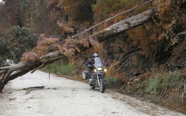
Anyhow, we travelled 70KM in total before we were turned back by a log that was a little too big to move by hand.
Only 8 km to go and I am in Corinna (assuming the road "block" at the other end was equally as unrestrictive), but here's what I found...
A few sections of the road that have large trees damaged by fire.
NO evidence at all that any work is being carried out to re-open this road.
If I had my chainsaw it would have stopped me for less than 5 minutes.
So we turned back and went to Sumac Lookout on the Arthur River Forest Drive - this wonderful drive, travelling through about all that is left of the Tarkine with the forestry operations clearly visible in Google satellite inages.
Here, at Sumac Lookout, is a sign indicating the Tayatea bridge was washed away in August 2007 and has not been replaced. So the Arthur River forest drive is a no through road - you would need to drive all the way to the bridge if you went the way we did had it not been for the sign we saw at Sumac Lookout, which you need to stop to notice.
So we turned around and continued toward Trowutta. (great names they've got out there).
Here we saw signs indicating the Tayatea bridge is closed.
So we came home, happy that we now know we won't be spending a week at the Tarkine or at Arthur River.
A couple of days ago I went to the Stanley Visitor Information Centre. I asked them about the Tarkine. They said "What would you like to know".
I initially asked about the Western Explorer. They said it was closed and that Parks are going to put to tender to have the burnt trees removed.
No idea when.
Then I asked about the Tayatea bridge, she said it was closed since the bridge was washed away in August 2007, but you can still get to all areas by going in from both ends.
I then asked about the Tarkine - what areas are publicly accessible. She said the Western Explorer and the Arthur River Forest Drive.
I said apart from those roads, what areas of the Tarkine are accessible to the public. She said that's it.
I thanked her and left.
If you have a look with Google's satellite images at the amount of logging that is going on around the Tarkine, any wonder there is nothing else that's accessible.
It is Forestry that is responsible for this bridge. I guess they don't need it to get any logs out from there.
My bet is that if they did, it wouldn't have been absent for 11 months (and counting).
I wonder why work STILL hasn't started on the Western Explorer? Or why Parks Tas (according to Stanley Visitor Centre) are charged with arranging to make this road safe.
Perhaps our state Infrastructure minister has some questions to answer.
Tarkine
Forum rules
Tasmania specific bushwalking discussion. Please avoid publishing details of access to sensitive areas with no tracks.
Tasmania specific bushwalking discussion. Please avoid publishing details of access to sensitive areas with no tracks.
100 posts
• Page 1 of 4 • 1, 2, 3, 4
Re: Tarkine
![]() by Speculator » Sun 06 Jul, 2008 12:34 pm
by Speculator » Sun 06 Jul, 2008 12:34 pm
Hi Adam,
That's a very thorough and informative investigation of the situation down there. Nice to see fellow 2WD'ers showing that you don't have to drive a truck just to go off the bitumen too!
It's a funny area the Tarkine, it's had a lot of media coverage in recent times, but is essentially under-publicised, under-maintained, under-developed (in terms of tourism access and services) and still pretty much remains undefined to a certain degree. I think the sad truth here is that without a major defining feature (something akin to Cradle Mt, The Hazards, The Gordon etc.) to make people want to look after it, it's going to be neglected. In fact, when it comes to protecting areas from logging, there seem to be so many hot-spots around the state that I really do think that the public probably suffer a sort of eco-fatigue.
I'm drifting off-topic a little, but I wonder whether the Tasmanian public can only cope with a certain amount of attention to areas that need protecting. We certainly know that the media are predisposed towards only concentrating on one big issue at a a time (same applies to politicians). Which in-turn makes me wonder whether the pulp mill debate is actually taking attention away from more important issues?
Anyway, enough thinking aloud. It's easy to see I'm tired and a little bored this morning!
---
Peak bagging points: 10. Peak bagging bagging points: 10000.
Peak bagging points: 10. Peak bagging bagging points: 10000.
-

Speculator - Optimus Imago

- Posts: 521
- Joined: Fri 15 Jun, 2007 10:35 pm
- Location: Ulverstone
- Region: Tasmania
Re: Tarkine
![]() by tasadam » Sun 06 Jul, 2008 2:39 pm
by tasadam » Sun 06 Jul, 2008 2:39 pm
Something else worth mentioning is that there is a lot of plantation timber gone in where the areas have been logged. And I mean a LOT.
Makes me think perhaps they are stripping out what forests they can to replace with plantation, so that once it's done, they will say we need a pulp mill like what else are we going to do with all this timber?
Makes me think perhaps they are stripping out what forests they can to replace with plantation, so that once it's done, they will say we need a pulp mill like what else are we going to do with all this timber?
-
tasadam - Magnus administratio

- Posts: 5940
- Joined: Tue 10 Apr, 2007 6:58 pm
- Location: Near Devonport, Tasmania
- ASSOCIATED ORGANISATIONS: TasmaniART, Smitten Merino, Macpac
- Region: Tasmania
- Gender: Male
Re: Tarkine
![]() by corvus » Sun 06 Jul, 2008 4:01 pm
by corvus » Sun 06 Jul, 2008 4:01 pm
I feel like I have a Polli question coming on so I will speak personally to our local members and ask them to enquire, when I have done this we may get a resulting answer or not .
collige virgo rosas
-

corvus - Vercundus gearus-freakius
- Posts: 5538
- Joined: Mon 23 Apr, 2007 7:24 pm
- Location: Devonport
- Region: Tasmania
- Gender: Male
Re: Tarkine
![]() by gorby » Sun 06 Jul, 2008 9:00 pm
by gorby » Sun 06 Jul, 2008 9:00 pm
We had a trip planned on the bikes from smithton to strahan on Anzac day weekend and we had heard how the bushfire ravaged the west coast explorer and closed it for two months.
The local police station knew nothing of the closure so we headed down there and the first sign we came across was at the turnoff ,kilometres away from where they should have been if we were to have made a decision to abort.
We ignored the signs that were layed over anyway and headed thru.The road was passable ,just
The fire was smouldering in a few places and the trees had blocked the table drains in a few places,but a good crew with the right equipment could have cleared it in a couple of weeks and replaced the burnt signs and guide posts.
here it is months later and it seems as though there still has been little progress or a better signage system,
obviously no politicians live down that way
-

gorby - Athrotaxis cupressoides

- Posts: 103
- Joined: Thu 20 Sep, 2007 9:24 am
- Location: deloraine
Re: Tarkine
![]() by corvus » Sun 06 Jul, 2008 9:30 pm
by corvus » Sun 06 Jul, 2008 9:30 pm
Gorby as usual good post from first hand experience,I have and will continue to address this with my local members and I am sending my next email now.
collige virgo rosas
-
corvus - Vercundus gearus-freakius
- Posts: 5538
- Joined: Mon 23 Apr, 2007 7:24 pm
- Location: Devonport
- Region: Tasmania
- Gender: Male
Re: Tarkine
![]() by tasadam » Mon 07 Jul, 2008 11:49 am
by tasadam » Mon 07 Jul, 2008 11:49 am
corvus wrote:Gorby as usual good post from first hand experience.
Ditto Gorby!
It's disgraceful that still nothing at all is happening.
The tree that turned our Corolla back was not quite as big as that one. Being that things were still smouldering this is likely to have been an area that was initially cleared before they reopened it for a short time.
We went down the day after the storm force winds, expecting to be turned back a long way before we did - looked for a while like we were going to make it.
Wish I had my chainsaw.
-
tasadam - Magnus administratio
- Posts: 5940
- Joined: Tue 10 Apr, 2007 6:58 pm
- Location: Near Devonport, Tasmania
- ASSOCIATED ORGANISATIONS: TasmaniART, Smitten Merino, Macpac
- Region: Tasmania
- Gender: Male
Re: Tarkine
![]() by MrCAMEL » Fri 18 Jul, 2008 11:51 pm
by MrCAMEL » Fri 18 Jul, 2008 11:51 pm
I've been somewhat fascinated by this road ever since i first drove it toward the end of last year. Living in Circular Head for only a short time, I always wanted to use the road more and explore the area more. Then the fire happened.
All the general public has got were very small updates in the newspaper every 6 weeks or so, telling the road was planned to be worked on in the next 2-3 weeks. Then, if i recall, 4-6 weeks ago, the assessment of the road was supposed to start 2 weeks later.
But now, the Forestry have been given the task of cleaning the road and should start planning in 2-4 weeks start cleaning 4-6 weeks later.
So i assume it wont be opened this year. Someone will find a way to put it off because they cant be bothered again.
But when (if) it does reopen, somehow there needs to be a great convoy, drive from Smithton to Corinna, somehow in protest of the complete laziness or incompetence of everyone involved in the stalling of reopening the road.
Same with the Tayatea fallen bridge. When it fell over, the plans were there straight away to quickly rebuild it and it sounded good. But no one did. Now apparently monies have been allocated to build a new bridge. But everyone still sounds like they want to try to make excuses to delay it.
I have no idea if i just typed anything
Part time reader,
First time poster.
Vrilen Snyson Racing: Finding us all a Vrilen
Asparagus: Experience the versatility
Asparagus: Experience the versatility
-

MrCAMEL - Athrotaxis cupressoides
- Posts: 104
- Joined: Fri 18 Jul, 2008 11:10 pm
- Location: Mongol Land
- Region: Other Country
Re: Tarkine
![]() by tasadam » Sat 19 Jul, 2008 8:14 am
by tasadam » Sat 19 Jul, 2008 8:14 am
Yes your post went in, and well.
Welcome to the forum.
Did anyone see the article in the Aggrovate this week?
For those that don't know, here in Tasmania, we have three newspapers - Hobarts Mockery (Mercury), Launceston's Exaggerater (Examiner), and the north west - the Aggrovate (Advocate).
http://nwtasmania.yourguide.com.au/news ... 10853.aspx
It seems to me that they are holding off on everything so they can build a new road through currently inaccessable areas, thus allowing them to get in there with their log trucks.
If time proves me wrong, so be it. I'd be happy to be wrong.
And there was another article in that paper worth reading. I just went to find it but found this instead.
http://nwtasmania.yourguide.com.au/news ... 11685.aspx
Seems I'm not the only one with negative thoughts.
The other article was our Permier talking about the Western Explorer. I'll have to find it because there is something worth mentioning...
-
tasadam - Magnus administratio
- Posts: 5940
- Joined: Tue 10 Apr, 2007 6:58 pm
- Location: Near Devonport, Tasmania
- ASSOCIATED ORGANISATIONS: TasmaniART, Smitten Merino, Macpac
- Region: Tasmania
- Gender: Male
Re: Tarkine
![]() by MrCAMEL » Tue 22 Jul, 2008 10:05 pm
by MrCAMEL » Tue 22 Jul, 2008 10:05 pm
-
MrCAMEL - Athrotaxis cupressoides
- Posts: 104
- Joined: Fri 18 Jul, 2008 11:10 pm
- Location: Mongol Land
- Region: Other Country
Re: Tarkine
![]() by Joe » Wed 23 Jul, 2008 10:25 am
by Joe » Wed 23 Jul, 2008 10:25 am
snippet in aggrovate today saying that work had begun on western explorer...1000 odd trees to be removed due to safety concerns, 6 weeks should pull them up.
-

Joe - in vino veritas
- Posts: 675
- Joined: Mon 26 Mar, 2007 10:35 pm
- Location: Devonport Tas
- ASSOCIATED ORGANISATIONS: Stoney Creek Outdoor Equipment.
- Region: Tasmania
Re: Tarkine
![]() by tastrekker » Sun 24 Aug, 2008 2:15 pm
by tastrekker » Sun 24 Aug, 2008 2:15 pm
tasadam wrote:I then asked about the Tarkine - what areas are publicly accessible. She said the Western Explorer and the Arthur River Forest Drive.
I said apart from those roads, what areas of the Tarkine are accessible to the public. She said that's it.
I thanked her and left.
This is a bit sad. There are heaps of areas where you can enjoy the Tarkine. I personally believe the Western Explorer is a very poor way to enjoy it.
My list of places which do not require the Western Explorer would be something like this:
McGowans Falls at West Takone
Wandle Falls at Parawe
Hellyer Gorge
The Rainforest Track (up to 5 days walking which requires swiming/wading/boating over the Arthur at Farquhars and Hilders crossings to start and finish - a loop is possible from Hilders Crossing if the really boring Keith River Road is endured)
Tarkine Falls (A 2-3 day walk in and out from Hilders Crossing using part of the Rainforest Track)
Galadriels Cascades (2/3 of the way in to Tarkine falls, could be done as a 1-2 day walk from Hilders Crossing)
Trowutta Arch
Milkshake Hills
Lake Chisolm
Sumac Lookout
Beckett Falls
(The last 4 items are on the currently one-way South Arthur Forest Drive which means a fair bit of back-tracking)
Sandy Cape to Pieman River (a ripper multi-day coastal walk requiring a car/ferry shuffle)
Mt Cleveland
Magnet Tramway (an 'easy' mountain bike circuit)
Mt Bertha (a serious undertaking south of the Rainforest Track)
Meredith Range (another serious undertaking from various access points on the Corinna Rd such as the Betts Track)
Mt Balfour
Peaks of the Norfolk Range (trackless walking from the undamaged northern section of the Western Explorer)
Reece Dam Road and Murchison Highway (these 2 roads already pass through some magnificent patches of typical Tarkine rainforest - I recommend the single lane, one-way tourist drive just south of Renison Bell)
Mt Farrell
Mt Murchison
Granville Harbour 4WD track (great for Mountain Bikes)
Arthur and Hellyer River rafting/kayaking (various grades available for single or multi-day trips between several different road access points)
While I'm in the mood for writing lists, I would also like to point out that the Tarkine is more intact than many people would realise. Check out the following list of reserves. These reserves cover a staggering 300,000+ hectares. But there's a catch (read on).
Arthur-Pieman Protected Area - 99,815
Roger River State Reserve - 175
Roger River Forest Reserve - 9,865
Trowutta Caves State Reserve - 65
Sumac Forest Reserve - 9,865
Donaldson River Nature Recreation Area - 30,657
Savage River Pipeline Forest Reserve - 31,025
Savage River Regional Reserve - 16,083
Savage River National Park - 17,981
Arthur River Forest Reserve - 3,230
Pruana Forest Reserve - 3,032
Hellyer Gorge State Reserve - 800
Deep Gully Forest Reserve - 2,553
Meredith Range Regional Reserve - 61,276
Yellow Creek State Reserve - 71
Pieman River State Reserve - 3,318
Tikkawoppa Plateau Regional Reserve - 4,534
Bernafai Ridge Conservation Area - 1,282
Hatfield River Forest Reserve - 1,098
John Lynch Forest Reserve - 3,128
Mackintosh Forest Reserve - 1,029
Mount Farrell Regional Reserve - 1,057
Mount Murchison Regional Reserve - 1,732
Huskisson River Forest Reserve - 690
Lake Pieman Forest Reserve - 1,008
Here's the catch...
Of the 305,369 hectares in reserves, only 19,021 hectares is protected from mining.
While I agree there are large areas of unprotected native forests on the fringes of the Tarkine that are under threat, there are also huge tracts of forest locked almost safely away in these reserves. They are safe, that is, unless someone wants something valuable from below the surface. I would love to know how careful mining companies have to be when conducting exporation or mining in the above reserves. Does the reserve status mean they have to be any more or less careful than on any other piece of public or private land?
I'll add one final list to my rant...
Reynolds Falls Nature Recreation Area - 11,759
Vale of Belvoir Conservation Area - 4,268
Granite Tor Conservation Area - 22,436
Mt Heemskirk Regional Reserve - 10,747
Parting Creek Regional Reserve - 1,881
Mount Dundas Regional Reserve - 11,540
Tyndall Range Regional Reserve - 12,687
Lake Beatrice Conservation Area - 2,970
Princess River Conservation Area - 8,635
Crotty Conservation Area - 4,420
West Coast Range Regional Reserve - 18,041
These reserves are outside the traditional boundaries of the 'Tarkine.' Why mention them? If they are added to the first list of reserves, it creates a massive area of 414,753 hectares which connects magnificently to a large percentage of the westen boundary of the existing World Heritage Area. It is even possible to almost connect the Tarkine to the Rocky Cape NP via a few more reserves around Dip and Detention Falls, the Shakespear Hills and Dip Range.
This huge potential addition to the world heritage area would mean large sections of the Anthony Road, Reece Dam Road, Murchison Highway and even a small stretch of the Bass Highway would pass through the WHA, opening up additional WHA exposure and signage opportunities. Marketing the wilderness values of the Tarkine Region would become much easier. However, without National Park status and a single well-defined boundary, I wonder weather it will ever be possible to turn the Tarkine into a marketable asset which will be able to pay its way in the lucrative eco-tourism market.
-

tastrekker - Athrotaxis cupressoides
- Posts: 498
- Joined: Thu 20 Sep, 2007 9:04 pm
- Location: Lenah Valley
- Region: Tasmania
- Gender: Male
Re: Tarkine
![]() by tasadam » Sun 12 Oct, 2008 7:43 am
by tasadam » Sun 12 Oct, 2008 7:43 am
The latest on the Western Explorer - http://www.realtasmania.com/index.php?s ... ost&p=3603
Incredible how long they drag their heels.
Incredible how long they drag their heels.
-
tasadam - Magnus administratio
- Posts: 5940
- Joined: Tue 10 Apr, 2007 6:58 pm
- Location: Near Devonport, Tasmania
- ASSOCIATED ORGANISATIONS: TasmaniART, Smitten Merino, Macpac
- Region: Tasmania
- Gender: Male
Re: Tarkine
![]() by MrCAMEL » Wed 22 Oct, 2008 10:05 am
by MrCAMEL » Wed 22 Oct, 2008 10:05 am
Woohoo!
The road is going to be opening this coming Friday. So I have been told.
Who's up for cruise?
The road is going to be opening this coming Friday. So I have been told.
Who's up for cruise?
Vrilen Snyson Racing: Finding us all a Vrilen
Asparagus: Experience the versatility
Asparagus: Experience the versatility
-
MrCAMEL - Athrotaxis cupressoides
- Posts: 104
- Joined: Fri 18 Jul, 2008 11:10 pm
- Location: Mongol Land
- Region: Other Country
Re: Tarkine
![]() by tasadam » Sat 25 Oct, 2008 7:11 am
by tasadam » Sat 25 Oct, 2008 7:11 am
MrCAMEL wrote:Woohoo!
The road is going to be opening this coming Friday. So I have been told.
Who's up for cruise?
Where'd you hear that?
From the Parks site today -
Maybe they just don't update their site. Maybe they don't know. Maybe someone told you a furphy. Maybe....... I can't think of any more maybe'sWestern Explorer Road Closed
Updated 25 September 2008
The Western Explorer Road on the West Coast is likely to remain closed until mid October in the aftermath of the recent large bushfire in the area.
Once clearing is completed, the Department of Infrastructure, Energy and Resources (DIER) will then have to assess the state of the road surface and repair it where necessary.
The road will therefore remain closed to all traffic until further notice.
For further details, contact Department of Infrastructure, Energy and Resources on 64346347 or 0418143030.
Aha Just thought of another maybe... Here.
One point of note -
Mr Sturges said that while the clean-up had taken longer than expected, the safety of the travelling public had been the paramount consideration in determining the reopening date.
Paramount - most important / highest / utmost.
I wonder what other reasons they considered.
-
tasadam - Magnus administratio
- Posts: 5940
- Joined: Tue 10 Apr, 2007 6:58 pm
- Location: Near Devonport, Tasmania
- ASSOCIATED ORGANISATIONS: TasmaniART, Smitten Merino, Macpac
- Region: Tasmania
- Gender: Male
Re: Tarkine
![]() by Speculator » Sat 25 Oct, 2008 8:07 am
by Speculator » Sat 25 Oct, 2008 8:07 am
Paramount - most important / highest / utmost.
I wonder what other reasons they considered.
Nice definition. We could use your talents on the Terminology category of the BTW Wiki Adam!
L8r.
---
Peak bagging points: 10. Peak bagging bagging points: 10000.
Peak bagging points: 10. Peak bagging bagging points: 10000.
-
Speculator - Optimus Imago
- Posts: 521
- Joined: Fri 15 Jun, 2007 10:35 pm
- Location: Ulverstone
- Region: Tasmania
Re: Tarkine
![]() by tasadam » Sat 25 Oct, 2008 2:16 pm
by tasadam » Sat 25 Oct, 2008 2:16 pm
I confess. I looked it up.
I made up the "most important" bit, but the other two were from some wictionary site I stumbled on (when I finally gor Google to ingore "Paramount pictures").
I made up the "most important" bit, but the other two were from some wictionary site I stumbled on (when I finally gor Google to ingore "Paramount pictures").
Speculator wrote:Paramount - most important / highest / utmost.
I wonder what other reasons they considered.
Nice definition. We could use your talents on the Terminology category of the BTW Wiki Adam!
L8r.
-
tasadam - Magnus administratio
- Posts: 5940
- Joined: Tue 10 Apr, 2007 6:58 pm
- Location: Near Devonport, Tasmania
- ASSOCIATED ORGANISATIONS: TasmaniART, Smitten Merino, Macpac
- Region: Tasmania
- Gender: Male
Re: Tarkine
![]() by MrCAMEL » Sun 26 Oct, 2008 7:55 pm
by MrCAMEL » Sun 26 Oct, 2008 7:55 pm
Well where I work, 2 journalists work on the small paper in the area where I live and I told them to let me know when anything happens (I asked in the first half of the year), so as soon as the media release thing came out they came out and told me. Which is nice .
So on Saturday, I was actually wanting to get up one of the few of the hills on the West Coast, Hazelton looked alright, but when I got there I realised I needed another map as I couldnt actually tell where I was meant to be.
So I just cruised down to Corinna and cruised all the way back up again . There was a great flurry of activity on the road too. For the day I encountered at least 10 vehicles, 8 motorbikers and one cyclist. So that was interesting. The road was in good condition, everything looked spectacular, good times.
So also, how and where is the best way to access the mountains in the Norfolk Range, for walking, and also Mount Bertha too?
So on Saturday, I was actually wanting to get up one of the few of the hills on the West Coast, Hazelton looked alright, but when I got there I realised I needed another map as I couldnt actually tell where I was meant to be.
So I just cruised down to Corinna and cruised all the way back up again
So also, how and where is the best way to access the mountains in the Norfolk Range, for walking, and also Mount Bertha too?
Vrilen Snyson Racing: Finding us all a Vrilen
Asparagus: Experience the versatility
Asparagus: Experience the versatility
-
MrCAMEL - Athrotaxis cupressoides
- Posts: 104
- Joined: Fri 18 Jul, 2008 11:10 pm
- Location: Mongol Land
- Region: Other Country
Re: Tarkine
![]() by flyfisher » Sun 26 Oct, 2008 8:44 pm
by flyfisher » Sun 26 Oct, 2008 8:44 pm
Thats great news that the road is open again. I'll bet the tourist operators in Corinna are happy that its in use well before Christmas so people will plan trips in the area. Maybe me too.
FF
FF
If you don't know what I'm talking about, then you need to drink more.
-
flyfisher - Athrotaxis selaginoides

- Posts: 1532
- Joined: Sat 14 Jul, 2007 8:39 pm
- Location: hobart
- ASSOCIATED ORGANISATIONS: landrover owners club of tasmania
- Region: Tasmania
Re: Tarkine
![]() by MrCAMEL » Wed 10 Dec, 2008 9:06 pm
by MrCAMEL » Wed 10 Dec, 2008 9:06 pm
I went a cruising down the so called Tarkine the weekend before last and explored a little bit.
Beautiful Tarkine.
I really cannot ever recall seeing this road, before this year, otherwise I would have been down it. So it must be a new road. I阰t isnt signposted yet either. Im not very good with trees and sometimes dont know the difference between plantations and real bush. H鹈owever, this is for sure not a plantation, but it is being made a mess of and an obvious road is being planted. It is near the Balfour Track Forest Reserve. M벨aybe it is the start of the mysterious Tarkine the 'Loop' drive but no one wants to tell anyone yet.


THE actual mission of the day was to walk up Mountain Hazelton.
I found a 4wd track that basically leads most the way up. At first I thought this was cheating, but then I decided it was just the same as following any other marked walking track.

There a couple of short and very steep hills on the way. But when I was on the side of the front peak, the dark clouds rolled in, the bushes were very thick and I heard a creature moving around which made me jump and with the speed of which it was moving i could see the trees swaying) through such thick bushes, scared me greatly. So I retreated quite swiftly, without making it to the actual highpoint.
I think it was one of those weed men.
From the side of the first main slope, awesome views of the West Coast beaches were visible. I only got 30 seconds worth of a view before they disappeared in the clouds, but they were so very shiny.
Then it poured rain directly into my face for half an hour and was completely soaked.
Great fun for 5 hours though.
The few minutes
Beautiful Tarkine.
I really cannot ever recall seeing this road, before this year, otherwise I would have been down it. So it must be a new road. I阰t isnt signposted yet either. Im not very good with trees and sometimes dont know the difference between plantations and real bush. H鹈owever, this is for sure not a plantation, but it is being made a mess of and an obvious road is being planted. It is near the Balfour Track Forest Reserve. M벨aybe it is the start of the mysterious Tarkine the 'Loop' drive but no one wants to tell anyone yet.
THE actual mission of the day was to walk up Mountain Hazelton.
I found a 4wd track that basically leads most the way up. At first I thought this was cheating, but then I decided it was just the same as following any other marked walking track.
There a couple of short and very steep hills on the way. But when I was on the side of the front peak, the dark clouds rolled in, the bushes were very thick and I heard a creature moving around which made me jump and with the speed of which it was moving i could see the trees swaying) through such thick bushes, scared me greatly. So I retreated quite swiftly, without making it to the actual highpoint.
I think it was one of those weed men.
From the side of the first main slope, awesome views of the West Coast beaches were visible. I only got 30 seconds worth of a view before they disappeared in the clouds, but they were so very shiny.
Then it poured rain directly into my face for half an hour and was completely soaked.
Great fun for 5 hours though.
The few minutes
Vrilen Snyson Racing: Finding us all a Vrilen
Asparagus: Experience the versatility
Asparagus: Experience the versatility
-
MrCAMEL - Athrotaxis cupressoides
- Posts: 104
- Joined: Fri 18 Jul, 2008 11:10 pm
- Location: Mongol Land
- Region: Other Country
Re: Tarkine
![]() by tasadam » Sun 21 Dec, 2008 7:20 am
by tasadam » Sun 21 Dec, 2008 7:20 am
They really don't give two hoots about what they do in there, do they... 
-
tasadam - Magnus administratio
- Posts: 5940
- Joined: Tue 10 Apr, 2007 6:58 pm
- Location: Near Devonport, Tasmania
- ASSOCIATED ORGANISATIONS: TasmaniART, Smitten Merino, Macpac
- Region: Tasmania
- Gender: Male
Re: Tarkine
![]() by Taurë-rana » Tue 30 Dec, 2008 9:59 pm
by Taurë-rana » Tue 30 Dec, 2008 9:59 pm
MrCAMEL wrote:I went a cruising down the so called Tarkine the weekend before last and explored a little bit.
This is what is happening in vast tracts of Tasmania's forests that most people don't see. I know I go on about it, but we explore a lot and everywhere we go in Tassie where we find fantastic, incredibly diverse forests, old growth or selectively logged last century (but still diverse and beautiful, just not acknowledged as worth saving), we find the devastation of logging coupes and bulldozed roads. I really don't think that most people know the extent of it.
Aside from that, thanks for your trip description MrCAMEL, I enjoyed reading it. I'm glad the weed man didn't get you, that's one problem I have with walking by myself at times - I get spooked.
Peak bagging points: 170ish
Recent walks - Picton, Wylds Crag, Rogoona
Recent walks - Picton, Wylds Crag, Rogoona
-

Taurë-rana - Athrotaxis selaginoides
- Posts: 1031
- Joined: Mon 14 Jan, 2008 8:28 pm
- Location: Devonport
- Region: Tasmania
Re: Tarkine
![]() by MrCAMEL » Wed 04 Feb, 2009 12:55 pm
by MrCAMEL » Wed 04 Feb, 2009 12:55 pm
She's all go 
http://www.abc.net.au/news/stories/2009 ... 481950.htm
Premier said, Quote marks.
The new section was 5.4km long.
653 hectares of forest earmarked for harvesting will be reserved for ever.
I appreciate the concern of those opposed to the road.
More people will be able to experience the beauty the area has to offer.
Vrilen Snyson Racing: Finding us all a Vrilen
Asparagus: Experience the versatility
Asparagus: Experience the versatility
-
MrCAMEL - Athrotaxis cupressoides
- Posts: 104
- Joined: Fri 18 Jul, 2008 11:10 pm
- Location: Mongol Land
- Region: Other Country
Re: Tarkine
![]() by tasadam » Wed 04 Feb, 2009 5:09 pm
by tasadam » Wed 04 Feb, 2009 5:09 pm
But then there is this
http://www.themercury.com.au/article/20 ... -news.html
I wonder when / if they are going to replace the bridge on the Arthur River Forest Drive that got washed away about 18 months ago.
Anyhow it makes no difference what I say, they will do what they want and I won't be stopping them.
http://www.themercury.com.au/article/20 ... -news.html
A NEW $23 million road in the Tarkine Wilderness has already been labelled a logging road rather than a bolster to tourism.
I wonder when / if they are going to replace the bridge on the Arthur River Forest Drive that got washed away about 18 months ago.
Anyhow it makes no difference what I say, they will do what they want and I won't be stopping them.
-
tasadam - Magnus administratio
- Posts: 5940
- Joined: Tue 10 Apr, 2007 6:58 pm
- Location: Near Devonport, Tasmania
- ASSOCIATED ORGANISATIONS: TasmaniART, Smitten Merino, Macpac
- Region: Tasmania
- Gender: Male
Re: Tarkine
![]() by GerryDuke » Wed 04 Feb, 2009 9:31 pm
by GerryDuke » Wed 04 Feb, 2009 9:31 pm
I have only just had time to read through this topic. Thanks Tastrekker for a great list of reserves and destinations in the Tarkine.
Does anyone have details or a map of where the proposed new Tarkine road will go!
For interest, I have a picture of the remains of the Tayatea bridge. I'm not on my own computer at present so I can't post it! However I have it on my homepage - bottom left of the page:
http://www.touringtasmania.info
As for the signage re the bridge being closed - If you drive from Smithton through Edith Creek a turnoff is reached 4 kms past Roger River. The road straight on heads towards Trowutta and the washed away Tayatea bridge. (Trowutta Arch is down Reynolds Road - turn left a few kms along the road). The turn to the right continues on to Kanunnah Bridge over The Arthur. About 500 metres along the latter mentioned road there is a very large sign indicating the Tayatea Bridge is out - one might ask why isn't the sign at the turnoff!! You would not see the sign if you headed straight on to the Tayatea Bridge. This was the situation about 6 monthe ago so the signage may have changed. They are not strong on communication as mentioned throughout the topic!
Gerry
Last edited by GerryDuke on Fri 06 Feb, 2009 10:20 pm, edited 2 times in total.
-
GerryDuke - Athrotaxis cupressoides
- Posts: 403
- Joined: Sun 18 May, 2008 12:04 am
- Location: KINGSTON BEACH, TASMANIA
- ASSOCIATED ORGANISATIONS: Operator of www.TouringTasmania.info web site
- Region: Tasmania
- Gender: Male
Re: Tarkine
![]() by MrCAMEL » Thu 05 Feb, 2009 6:50 am
by MrCAMEL » Thu 05 Feb, 2009 6:50 am
GerryDuke wrote:I have only just had time to read through this topic. Thanks Tastrekker for a great list of reserves and destinations in the Tarkine.
Does anyone have details or a map of where the proposed new Tarkine road will go!
For interest, I have a picture of the remains of the Tayatea bridge. I'm not on my own computer at present so I can't post it! However I have it on my homepage - bottom left of the page:
http://www.touringtasmania.info
As for the signage re the bridge being closed - If you drive from Smithton through Edith Creek a turnoff is reached 4 kms past Roger River. The road straight on heads towards Trowutta and the washed away Tayatea bridge. (Trowutta Arch is down Donalds Road - turn left a few kms along the road). The turn to the right continues on to Kanunnah Bridge over The Arthur. About 500 metres along the latter mentioned road there is a very large sign indicating the Tayatea Bridge is out - one might ask why isn't the sign at the turnoff!! You would not see the sigh if you headed straight on the the Tayatea Bridge. This was the situation about 6 monthe ago so the signage may have changed. They are not strong on communication as mentioned throughout the topic!
Gerry
The Arch is on Reynolds Rd, no Donalds
I saw a document on one of the proposed routes for the road a few months ago. I couldn't find it online anywhere, but when I find out if it is the route that has been chosen, I will scan it or something and post it up here.
There is a sign at the Roger River Rd turnoff that states "Tayatea Bridge Out". I dont even know what that means. Surely it would be better to have washed away or collapsed, it sounds better. There is another one at the Trowutta/Reids Rd intersection. They are extremely faded and it is not possible to read them from incar.
Vrilen Snyson Racing: Finding us all a Vrilen
Asparagus: Experience the versatility
Asparagus: Experience the versatility
-
MrCAMEL - Athrotaxis cupressoides
- Posts: 104
- Joined: Fri 18 Jul, 2008 11:10 pm
- Location: Mongol Land
- Region: Other Country
Re: Tarkine
![]() by GerryDuke » Thu 05 Feb, 2009 1:56 pm
by GerryDuke » Thu 05 Feb, 2009 1:56 pm
Thanks for the Reynolds Road correction - was relying on my memory!! Fixed.
-
GerryDuke - Athrotaxis cupressoides
- Posts: 403
- Joined: Sun 18 May, 2008 12:04 am
- Location: KINGSTON BEACH, TASMANIA
- ASSOCIATED ORGANISATIONS: Operator of www.TouringTasmania.info web site
- Region: Tasmania
- Gender: Male
Re: Tarkine
![]() by MrCAMEL » Thu 05 Feb, 2009 7:19 pm
by MrCAMEL » Thu 05 Feb, 2009 7:19 pm
I found a little bit of info that now seems relevant. http://www.circularhead.tas.gov.au/webd ... inutes.pdf
Go to about page 45. Did the government choose the FT preffered route? I think they did. It has a small bit of detail.
Roads will lead to a "Tarkine Lookout" and the Tarkine Falls as well as 'facilities' at Phantom Peak. I have not been in there before but I really would like to before they slap a road down there. The 5 or 7km of road, that they claim is the only 'new' road that will need to contructed is a pointless thing to say too. I am sure some of the roads they would plan to upgrade would be in such a bad state that it would effectively be like starting from scrath anyways.
But i'm not sure. A sealed road between Temma and Myalla via the Tarkine Falls would kill all the fun.
Vrilen Snyson Racing: Finding us all a Vrilen
Asparagus: Experience the versatility
Asparagus: Experience the versatility
-
MrCAMEL - Athrotaxis cupressoides
- Posts: 104
- Joined: Fri 18 Jul, 2008 11:10 pm
- Location: Mongol Land
- Region: Other Country
Re: Tarkine
![]() by tasadam » Thu 05 Feb, 2009 8:05 pm
by tasadam » Thu 05 Feb, 2009 8:05 pm
Interesting report. Great find.
I note the second paragraph of page 48 which is FT selling the idea to CHC by putting dollar signs in their eyes, even though the detail is clouded by ambiguous words (see "may", "likely", "could").
Would I use the road if it is built? Yes. Who wouldn't. Once it's there, it's there, period.
But my personal observations are such that the whole Tarkine area needs a decent management / co-operation approach.
Go to Corinna and ask about what there is to do in the area, they will tell you of the day walks that can be done from there, or that the boat will take you upstream for a look, and when you ask them about overnight bushwalks or camping, they tell you there are none. Try it - my wife did. Nothing all the way to Stanley, she was told. This was on 24th Jan this year.
I suspect the reasoning was so they can charge you for their campsites and have you spend your tourism dollar in their town. All very sad.
Go to my original post in this topic and read about the other examples highlighting a lack of cooperation or information regarding the promotion of this area.
Go to do the Arthur River Forest drive - it has been closed because of a bridge that has been "out" (read "washed away") since August 2007.
Have a look at how long it took them to reopen the Western Explorer after the fires - and there was talk at the time that it would not reopen. Even though I was able to travel 70KM of this 78KM drive unimpeeded (apart from an attempt at a speed bump at the northern end, and a road closed sign).
If all the important tourism bodies and information centre people from little centres of Arthur River, Temma, Trotta (apparently that's how you say Trowutta if you're from that way), Corinna etc got together over a beer and discussed what it was that the Tarkine did for them, then came up with a plan, maybe then they would be on the right track to doing some good with this area.
Instead, it seems FT drive the bus and everyone else is a passenger, so each area looks after their own nest, so to speak.
Meanwhile, the log trucks roll. Keeping those truckies and forest workers in a job, keeping their families in the area with food on the table, keeping the economies of the areas ticking over.
That's got to be a good thing, right? Or is there a better way to have this forest earn them all a quid..... While it's still there.
-
tasadam - Magnus administratio
- Posts: 5940
- Joined: Tue 10 Apr, 2007 6:58 pm
- Location: Near Devonport, Tasmania
- ASSOCIATED ORGANISATIONS: TasmaniART, Smitten Merino, Macpac
- Region: Tasmania
- Gender: Male
100 posts
• Page 1 of 4 • 1, 2, 3, 4
Who is online
Users browsing this forum: No registered users and 114 guests