Hi
Planning to do some of the Hume and Hovell track in late September. We don't have time to do the whole 400k, so am wondering what people would recommend as the most scenic section...7 to 10 days walking max. Walking through pine forests is not appealing.
ideally we'd be able to access each end of the recommended stages by public tspt but this is not essential...our aim is to walk the most scenic part.
Thanks for your help.
Sasha
Best part of Hume and Hovell track for 10 day walk
Forum rules
NSW & ACT specific bushwalking discussion. Please avoid publishing details of access to sensitive areas with no tracks.
NSW & ACT specific bushwalking discussion. Please avoid publishing details of access to sensitive areas with no tracks.
2 posts
• Page 1 of 1
Best part of Hume and Hovell track for 10 day walk
![]() by Sasha » Sat 04 Aug, 2012 9:23 pm
by Sasha » Sat 04 Aug, 2012 9:23 pm
- Sasha
- Nothofagus gunnii

- Posts: 16
- Joined: Sat 04 Aug, 2012 9:18 pm
- Region: New South Wales
- Gender: Female
Re: Best part of Hume and Hovell track for 10 day walk
![]() by WarrenH » Tue 07 Aug, 2012 7:53 pm
by WarrenH » Tue 07 Aug, 2012 7:53 pm
Get the map kit ... if you haven't already. There is a lot of good info in the map kit. Then go and explore the track. NSW Gov's Six Lite site has the greater topos, if you are an explorer. The H&H is a track of exploration ... other wise, buy a book and go virtual.
You can do a walk through Woomergama NP (Map #5) and back (great views west of the Tin Mines of the Victorian Alps). Along the Gooberragandra River (Map# 2 & 3) (with a large extended side trip into Bobby's Plains and the Bogong Peaks) pine free wildernss, otherwise, it is NSW Forestry's track. The forests of the Tumut Region from south of Mount Wee Jasper to Michalong Swamp have that strong aromatic pine smell. I like that section around Nottingham Hills and North of the Nottingham Hills. From the Fitzpatrick Track Head climb Mount Wee Jasper and return, then head north past Careys Cave Reserve and west over Mount Goodradigee. From Carey's Cave reserve you can head north to Dutton's Bluff and climb to Black Andrew and check out the gorge, that's full-on. The property to cross after Carey Cave Reserve is Cooradigbee if heading North (they have a website and a guesthouse). There is a track beside the water going 3/4 way to Duttons Bluff.
This is not a track for ticking boxes or travelling point to point, not if you're intrepid.
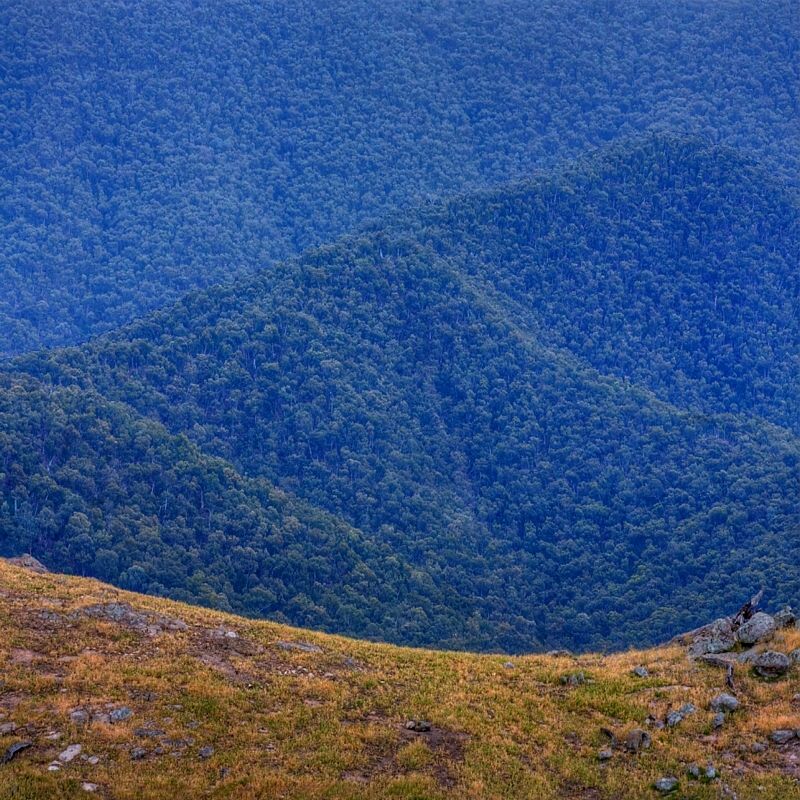
Native Dog Reserve, Mount Goodradigbee taken from Sugarloaf Travelling Stock Reserve.
I'm just about to head off and do several of the Traveling Stock Routes West of The Rock, back through the Riverena and then linking to several dozen TS Reserves out on the SW Slopes, eventually to join the H&H somewhere near Lankey's Creek. I'm hoping to make it to the tracks across the Northern Alps on my mountain bike, in time for the reopening of the roads through the mountains, that's if the roads are rideable by then and not too soggy. The roads in Northern Kosciuszko re-open on the October long weekend.
Good luck with your trip.
Warren.
You can do a walk through Woomergama NP (Map #5) and back (great views west of the Tin Mines of the Victorian Alps). Along the Gooberragandra River (Map# 2 & 3) (with a large extended side trip into Bobby's Plains and the Bogong Peaks) pine free wildernss, otherwise, it is NSW Forestry's track. The forests of the Tumut Region from south of Mount Wee Jasper to Michalong Swamp have that strong aromatic pine smell. I like that section around Nottingham Hills and North of the Nottingham Hills. From the Fitzpatrick Track Head climb Mount Wee Jasper and return, then head north past Careys Cave Reserve and west over Mount Goodradigee. From Carey's Cave reserve you can head north to Dutton's Bluff and climb to Black Andrew and check out the gorge, that's full-on. The property to cross after Carey Cave Reserve is Cooradigbee if heading North (they have a website and a guesthouse). There is a track beside the water going 3/4 way to Duttons Bluff.
This is not a track for ticking boxes or travelling point to point, not if you're intrepid.
Native Dog Reserve, Mount Goodradigbee taken from Sugarloaf Travelling Stock Reserve.
I'm just about to head off and do several of the Traveling Stock Routes West of The Rock, back through the Riverena and then linking to several dozen TS Reserves out on the SW Slopes, eventually to join the H&H somewhere near Lankey's Creek. I'm hoping to make it to the tracks across the Northern Alps on my mountain bike, in time for the reopening of the roads through the mountains, that's if the roads are rideable by then and not too soggy. The roads in Northern Kosciuszko re-open on the October long weekend.
Good luck with your trip.
Warren.
- WarrenH
- Phyllocladus aspleniifolius

- Posts: 991
- Joined: Thu 07 Jan, 2010 6:54 pm
- Region: Australian Capital Territory
2 posts
• Page 1 of 1
Return to New South Wales & ACT
Who is online
Users browsing this forum: No registered users and 18 guests