Planning to walk Mt Currockbilly in the Budawang NP this weekend.
The Ron Doughton book suggests that you need permission to get access to Mt Currockbilly. Some blogs indicate you don't. Topo indicates locked gates.
Has anyone done this recently or know whether the gates marked on the topo are really locked or not? Also if permission is required to gain access through gates, does anyone have the contact details?
Thanks
Mt Currockbilly Access
Forum rules
NSW & ACT specific bushwalking discussion. Please avoid publishing details of access to sensitive areas with no tracks.
NSW & ACT specific bushwalking discussion. Please avoid publishing details of access to sensitive areas with no tracks.
16 posts
• Page 1 of 1
Mt Currockbilly Access
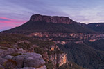
![]() by Huntsman247 » Tue 16 Apr, 2019 11:27 pm
by Huntsman247 » Tue 16 Apr, 2019 11:27 pm
-
Huntsman247 - Phyllocladus aspleniifolius

- Posts: 584
- Joined: Wed 22 Mar, 2017 10:07 pm
- Region: New South Wales
- Gender: Male
Re: Mt Currockbilly Access
![]() by LachlanB » Wed 17 Apr, 2019 12:26 am
by LachlanB » Wed 17 Apr, 2019 12:26 am
Disclaimer: it's been nearly two years since I was last up Currockbilly
However, then we parked at GR284793ish and followed the easement up and over the small knoll to east. There was a footpad that had developed suggested that was common use. The track to the north-east from this point to the park boundary apparently is supposed to have public right of way, but at that point the owner had chained it shut with a lock. None of the earlier gates were locked. The track up Currockbilly itself had become noticeably more overgrown from when I'd previously been up there in 2014, so I suspect it is even moreso now. Beautiful up the top though!
However, then we parked at GR284793ish and followed the easement up and over the small knoll to east. There was a footpad that had developed suggested that was common use. The track to the north-east from this point to the park boundary apparently is supposed to have public right of way, but at that point the owner had chained it shut with a lock. None of the earlier gates were locked. The track up Currockbilly itself had become noticeably more overgrown from when I'd previously been up there in 2014, so I suspect it is even moreso now. Beautiful up the top though!
- LachlanB
- Athrotaxis cupressoides

- Posts: 381
- Joined: Mon 21 Apr, 2014 5:07 pm
- Region: New South Wales
- Gender: Male
Re: Mt Currockbilly Access
![]() by michael_p » Wed 17 Apr, 2019 9:39 am
by michael_p » Wed 17 Apr, 2019 9:39 am
I thought I had a copy of the Doughton book but I can't find it. So I can't comment on his route.
Using the start point as described in this blog post: http://mntviews.blogspot.com/2015/06/cu ... ralia.html and this one: https://www.johnevans.id.au/wp/30-june- ... -mountain/ . I checked the access road used by both bloggers on the NSW SIX maps and it shows that the access road is connected to Charleys Forest Road. There is no boundary line shown on the SIX map between the access road and Charleys Forest Rd or the access road and the NP.
I am no expert but it appears to be a legal access point. It also appears that the locked gates as shown on the topo either aren't locked or don't exist. I expect that the local land owners have probably put a gate up at the main road to stop people from driving down the access road.
Michael.
One foot in front of the other.
-
michael_p - Athrotaxis selaginoides

- Posts: 1378
- Joined: Sun 15 Nov, 2009 6:58 pm
- Location: Macarthur Region of Sydney.
- Region: New South Wales
- Gender: Male
Re: Mt Currockbilly Access
![]() by Mark F » Wed 17 Apr, 2019 4:35 pm
by Mark F » Wed 17 Apr, 2019 4:35 pm
No recent knowledge but I did Currockbilly many years ago from Yadboro Flat. We walked up the Yadboro River to Currockbilly and the returned along Wirritin Ridge.
"Perfection is attained not when there is nothing more to add, but when there is nothing more to remove".
-

Mark F - Lagarostrobos franklinii

- Posts: 2332
- Joined: Mon 19 Sep, 2011 8:14 pm
- Region: Australian Capital Territory
- Gender: Male
Re: Mt Currockbilly Access
![]() by Huntsman247 » Wed 17 Apr, 2019 5:37 pm
by Huntsman247 » Wed 17 Apr, 2019 5:37 pm
michael_p wrote:I thought I had a copy of the Doughton book but I can't find it. So I can't comment on his route.
Using the start point as described in this blog post: http://mntviews.blogspot.com/2015/06/cu ... ralia.html and this one: https://www.johnevans.id.au/wp/30-june- ... -mountain/ . I checked the access road used by both bloggers on the NSW SIX maps and it shows that the access road is connected to Charleys Forest Road. There is no boundary line shown on the SIX map between the access road and Charleys Forest Rd or the access road and the NP.
I am no expert but it appears to be a legal access point. It also appears that the locked gates as shown on the topo either aren't locked or don't exist. I expect that the local land owners have probably put a gate up at the main road to stop people from driving down the access road.
Michael.
Thanks everyone. Looks like you might be right Michael. I've compared the SIX mosaic to the SIX topo and it does look like the SIX mosaic maps might be a bit outdated here as the simpler topo map shows only a gate instead of numerous locked gates. I'll give it a go and confirm back here.
-
Huntsman247 - Phyllocladus aspleniifolius
- Posts: 584
- Joined: Wed 22 Mar, 2017 10:07 pm
- Region: New South Wales
- Gender: Male
Re: Mt Currockbilly Access
![]() by Huntsman247 » Wed 17 Apr, 2019 5:50 pm
by Huntsman247 » Wed 17 Apr, 2019 5:50 pm
Mark F wrote:No recent knowledge but I did Currockbilly many years ago from Yadboro Flat. We walked up the Yadboro River to Currockbilly and the returned along Wirritin Ridge.
That sounds like quite a work out Mark. I intend to walk the top of the wirritin basin to have a look at that ridge. I like the idea of going from Currockbilly, down the ridge and up Snedden Pass before coming out at wog wog. How did you go for water when you did your trip? Am I correct in assuming there is none for the length of the ridge? And that the Yadboro river is it?
-
Huntsman247 - Phyllocladus aspleniifolius
- Posts: 584
- Joined: Wed 22 Mar, 2017 10:07 pm
- Region: New South Wales
- Gender: Male
Re: Mt Currockbilly Access
![]() by Huntsman247 » Tue 23 Apr, 2019 11:13 am
by Huntsman247 » Tue 23 Apr, 2019 11:13 am
Had a great day yesterday. Access is straight forward. Just a couple gates but no lock.
As I drove past the wog wog camp ground I could not believe the amount of cars parked there. Cars were parked along the main road as there was no space in the carpark. I'd say around 50-60 cars. The corang loop and Burrumbeet Brook camp caves must have been hammered...
On the contrary, we didn't see a soul. I can't believe how unfrequented this walk is (note the last 2 entries in the log book). And how old the book is.
Brilliant place to have a beer!
It clouded over after we had lunch so didn't bother to check out wirritin ridge. Might come back after a bit of snow.
Most of the way up is pretty straight forward and I would call it a track most of the way up but if you plan on doing a bit of a loop the ridge that takes you towards the wirritin basin that was rather overgrown but otherwise everything else was rather open bushland.
-
Huntsman247 - Phyllocladus aspleniifolius
- Posts: 584
- Joined: Wed 22 Mar, 2017 10:07 pm
- Region: New South Wales
- Gender: Male
Re: Mt Currockbilly Access
![]() by Mark F » Tue 23 Apr, 2019 9:45 pm
by Mark F » Tue 23 Apr, 2019 9:45 pm
Huntsman247 wrote:Mark F wrote:No recent knowledge but I did Currockbilly many years ago from Yadboro Flat. We walked up the Yadboro River to Currockbilly and the returned along Wirritin Ridge.
That sounds like quite a work out Mark. I intend to walk the top of the wirritin basin to have a look at that ridge. I like the idea of going from Currockbilly, down the ridge and up Snedden Pass before coming out at wog wog. How did you go for water when you did your trip? Am I correct in assuming there is none for the length of the ridge? And that the Yadboro river is it?
It was a nice two day kbc club trip but one of the very few where we were overdue due to two members of the party picking a bad spur to descend coming down Wirritin RIdge. We parked at Yadboro Flat and walked up the river until it became a problem then climbed out north to the ridge running off Currockbilly. Dry? camp under Currockbilly - I don't remember whether there was water in the very top end of the Yadboro River but remember walking to the top of Currockbilly in the dark, seeing lights in the distance and hearing farm dogs barking. Next day the long totally dry walk down Wirritin Ridge to the Yadboro River - quite open ridge top but some awkward navigation (pre gps) avoiding unintended spurs and remaining on the ridge unlike the two who stuffed up.
"Perfection is attained not when there is nothing more to add, but when there is nothing more to remove".
-
Mark F - Lagarostrobos franklinii
- Posts: 2332
- Joined: Mon 19 Sep, 2011 8:14 pm
- Region: Australian Capital Territory
- Gender: Male
Re: Mt Currockbilly Access
![]() by mirv2535 » Sun 16 Jun, 2019 11:30 am
by mirv2535 » Sun 16 Jun, 2019 11:30 am
This is great thanks we are heading out there next weekend!
- mirv2535
- Nothofagus gunnii

- Posts: 32
- Joined: Mon 04 Apr, 2016 7:49 pm
- Region: New South Wales
Re: Mt Currockbilly Access
![]() by Huntsman247 » Sun 16 Jun, 2019 7:05 pm
by Huntsman247 » Sun 16 Jun, 2019 7:05 pm
It's a great walk! I'd be interested to see how many people have been there since.mirv2535 wrote:This is great thanks we are heading out there next weekend!
-
Huntsman247 - Phyllocladus aspleniifolius
- Posts: 584
- Joined: Wed 22 Mar, 2017 10:07 pm
- Region: New South Wales
- Gender: Male
Re: Mt Currockbilly Access
![]() by puredingo » Mon 17 Jun, 2019 4:47 pm
by puredingo » Mon 17 Jun, 2019 4:47 pm
All I can add to this topic is that if you are planning on walking up the Yadboro river plan on getting wet feet.
I came down from Sneddon pass a year or two ago and from that spur basically up to the long gully camp it’s a lot easier and quicker to abandon the banks.
I came down from Sneddon pass a year or two ago and from that spur basically up to the long gully camp it’s a lot easier and quicker to abandon the banks.
- puredingo
- Athrotaxis selaginoides
- Posts: 1270
- Joined: Mon 13 Feb, 2012 6:54 am
- Region: New South Wales
Re: Mt Currockbilly Access
![]() by mirv2535 » Sun 23 Jun, 2019 5:56 pm
by mirv2535 » Sun 23 Jun, 2019 5:56 pm
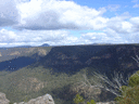
Just did the climb to the summit and out to the East Peak, what a sensational hike and amazing views!!!
- mirv2535
- Nothofagus gunnii
- Posts: 32
- Joined: Mon 04 Apr, 2016 7:49 pm
- Region: New South Wales
Re: Mt Currockbilly Access
![]() by andyw » Tue 29 Jun, 2021 5:57 pm
by andyw » Tue 29 Jun, 2021 5:57 pm
Just curious. Where is it best to access the start of the climb?
There seem to be a few alternatives. Which is most convenient in terms of access/private land etc?
Is an ascent to spot height 953, taking in the main summit, going out to east summit and then to the log book too ambitious for a long day walk?
There seem to be a few alternatives. Which is most convenient in terms of access/private land etc?
Is an ascent to spot height 953, taking in the main summit, going out to east summit and then to the log book too ambitious for a long day walk?
- andyw
- Nothofagus cunninghamii

- Posts: 1
- Joined: Sat 19 Jun, 2021 7:04 pm
- Region: New South Wales
- Gender: Male
Re: Mt Currockbilly Access
![]() by Huntsman247 » Tue 29 Jun, 2021 8:21 pm
by Huntsman247 » Tue 29 Jun, 2021 8:21 pm
The "traditional" way up would be to head for the peak northwest of Currockbilly. then head for the summit. If you are confident in navigating and are reasonably fit it can comfortably be done in a day even with exploring the basin and making a loop of the walk. Just keep in mind it's decently steep on the ascent and I suppose decent. Bushwalking in the Budawangs book will give you all the details you need.
There's track till the first peak then you can pick it back up close to the summit. No track after the logbook.
Scrub has been thinned out in recent times so following your ridge would probably be just as doable although unsure as to the access through properties. You might find yourself walking quite a few kms on fire trails to begin.
If you go that route, it would be interesting to hear about how you went.
-
Huntsman247 - Phyllocladus aspleniifolius
- Posts: 584
- Joined: Wed 22 Mar, 2017 10:07 pm
- Region: New South Wales
- Gender: Male
Re: Mt Currockbilly Access
![]() by sandym » Tue 11 Jul, 2023 4:06 pm
by sandym » Tue 11 Jul, 2023 4:06 pm
Finally did this walk which has been on my list for ages. Parked at the end of the road after passing just one closed but not locked gate. There were cows in the road allowance so I assume that is why the gate was closed. Also a rudimentary electric fence to keep the cows in the road allowance.
We took the standard route up as detailed on John Evans blog and it seems like more people must be doing this walk than signing the log book as there were cairns almost the whole way and a pretty good footpad for a good part of the distance too. But, only two other parties signed the log book this year. However, people may visit the summit and not the log book as strangely, the log book is not on the summit but in the saddle NE of the summit.
Very good views and walking like you remember from before the big fires of 2019/2020.
Happy to send detailed driving directions and gpx track from my watch if you contact me.
- sandym
- Phyllocladus aspleniifolius
- Posts: 515
- Joined: Wed 19 Sep, 2012 7:34 pm
- Region: New South Wales
- Gender: Female
16 posts
• Page 1 of 1
Return to New South Wales & ACT
Who is online
Users browsing this forum: sandym and 35 guests