G’day all,
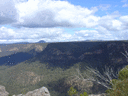
On Sunday I thought I’d take a leisurely stroll out the Hoddles track and check the flow of the Nattai river from above as I haven’t been this end of town before.
On reaching the terminus of the 4 lane fire trail and being injured that’s all I planned to do but I can’t help myself and thought “bugger it” and decided to go down to get a frogs eyes view of the river in full swing. ...where is the track? I’m sure I’ve read somewhere there is a track off this point but I couldn’t find track, cairn, tape or footprint. It was no problem entering the valley I just picked my way off the furthest reaching rocky outcrop, dropped off and bashed my way down to the water. But I’d rather follow an established track rather than disturb settled ground.
Also about midway along there’s a small farm road that branches off to the left, I followed this for awhile until it turned into impenetrable weeds where I bashed Back up onto the ridge again hoping to meet the road...which I did. Anyone know where that ends up?
Hoddles track Lakeland’s.
Forum rules
NSW & ACT specific bushwalking discussion. Please avoid publishing details of access to sensitive areas with no tracks.
NSW & ACT specific bushwalking discussion. Please avoid publishing details of access to sensitive areas with no tracks.
12 posts
• Page 1 of 1
Hoddles track Lakeland’s.
![]() by puredingo » Mon 29 Mar, 2021 8:33 am
by puredingo » Mon 29 Mar, 2021 8:33 am
- puredingo
- Athrotaxis selaginoides

- Posts: 1270
- Joined: Mon 13 Feb, 2012 6:54 am
- Region: New South Wales
Re: Hoddles track Lakeland’s.
![]() by michael_p » Mon 29 Mar, 2021 9:28 am
by michael_p » Mon 29 Mar, 2021 9:28 am
You sure you haven't got this confused with Hoddles Track at Kiama. As far as I am aware there is no track off the end of Hoddles at Lakesland. I am pretty sure it is within the forbidden zone so you are not allowed to walk out there. I have heard of a bushwalking club walking out to Eastwood and Perrott Bluffs but not Hoddles.
Last edited by michael_p on Mon 29 Mar, 2021 11:40 am, edited 1 time in total.
One foot in front of the other.
-
michael_p - Athrotaxis selaginoides
- Posts: 1378
- Joined: Sun 15 Nov, 2009 6:58 pm
- Location: Macarthur Region of Sydney.
- Region: New South Wales
- Gender: Male
Re: Hoddles track Lakeland’s.
![]() by puredingo » Mon 29 Mar, 2021 11:24 am
by puredingo » Mon 29 Mar, 2021 11:24 am
Definitely not Kiama, Michael. I’m from the South coast and know that one well.
Just google earthed it and it actually shows the track on there meeting the river?....plot thickens.
Just google earthed it and it actually shows the track on there meeting the river?....plot thickens.
- puredingo
- Athrotaxis selaginoides
- Posts: 1270
- Joined: Mon 13 Feb, 2012 6:54 am
- Region: New South Wales
Re: Hoddles track Lakeland’s.
![]() by michael_p » Mon 29 Mar, 2021 4:20 pm
by michael_p » Mon 29 Mar, 2021 4:20 pm
OK, no worries. Never heard of a track out that way so the plot does thicken.
One foot in front of the other.
-
michael_p - Athrotaxis selaginoides
- Posts: 1378
- Joined: Sun 15 Nov, 2009 6:58 pm
- Location: Macarthur Region of Sydney.
- Region: New South Wales
- Gender: Male
Re: Hoddles track Lakeland’s.
![]() by Warin » Mon 29 Mar, 2021 5:07 pm
by Warin » Mon 29 Mar, 2021 5:07 pm
OSM
https://www.openstreetmap.org/way/10602 ... 9/150.4766
Track 'to the left' looks to be W4P Firetrail ... off to Blue Gum Mountain + Eastwood Bluff. With another side track unnamed off to Perrott Bluff.
Not sighted a walking path... did not look hard.
https://www.openstreetmap.org/way/10602 ... 9/150.4766
Track 'to the left' looks to be W4P Firetrail ... off to Blue Gum Mountain + Eastwood Bluff. With another side track unnamed off to Perrott Bluff.
Not sighted a walking path... did not look hard.
-

Warin - Athrotaxis selaginoides
- Posts: 1419
- Joined: Sat 11 Nov, 2017 8:02 am
- Region: New South Wales
Re: Hoddles track Lakeland’s.
![]() by puredingo » Mon 29 Mar, 2021 7:05 pm
by puredingo » Mon 29 Mar, 2021 7:05 pm
Nah Warin, that track to left is a drivable, very obvious fire trail, the one I was referring to is more you older, grown over farm road and bit further along.
If you google earth the road the image definitely shows the fire trail ending and an extension track or road heading down to the river bank?
Would of thought there would be a local on here with a bit of inside knowledge...perhaps I’ve said too much!!
If you google earth the road the image definitely shows the fire trail ending and an extension track or road heading down to the river bank?
Would of thought there would be a local on here with a bit of inside knowledge...perhaps I’ve said too much!!
- puredingo
- Athrotaxis selaginoides
- Posts: 1270
- Joined: Mon 13 Feb, 2012 6:54 am
- Region: New South Wales
Re: Hoddles track Lakeland’s.
![]() by michael_p » Mon 29 Mar, 2021 7:57 pm
by michael_p » Mon 29 Mar, 2021 7:57 pm
I think I know what is going on now.
Refer the below image from Google Maps. It shows Hoddles Track as continuing down and meeting the Orange Tree Flat Trail. I assume you are talking about the section between the arrows I have added. If so, then I had a look at the historical imagery from 2009 on Google Earth and it sure does look like Hoddles did go down to the Orange Tree Flat Trail.
Maybe once upon a time there was a track but it is no more.
One foot in front of the other.
-
michael_p - Athrotaxis selaginoides
- Posts: 1378
- Joined: Sun 15 Nov, 2009 6:58 pm
- Location: Macarthur Region of Sydney.
- Region: New South Wales
- Gender: Male
Re: Hoddles track Lakeland’s.
![]() by michael_p » Mon 29 Mar, 2021 8:13 pm
by michael_p » Mon 29 Mar, 2021 8:13 pm
puredingo wrote:Also about midway along there’s a small farm road that branches off to the left, I followed this for awhile until it turned into impenetrable weeds where I bashed Back up onto the ridge again hoping to meet the road...which I did. Anyone know where that ends up?
Do you mean the track I have put a pin on. It goes a long way down but gets lost in the scrub so no way to tell how far it goes. Could be an alternate way down to Little River. Although it should be noted that it is most likely to be inside the forbidden zone as well.
Michael.
One foot in front of the other.
-
michael_p - Athrotaxis selaginoides
- Posts: 1378
- Joined: Sun 15 Nov, 2009 6:58 pm
- Location: Macarthur Region of Sydney.
- Region: New South Wales
- Gender: Male
Re: Hoddles track Lakeland’s.
![]() by puredingo » Tue 30 Mar, 2021 6:45 am
by puredingo » Tue 30 Mar, 2021 6:45 am
Thanks Michael, I knew wasn’t going completely insane...yet.
As far as that image goes concerning the track down to OTF trail it is pretty inaccurate. That is a sheer drop following the map line, Like I said earlier I followed the rocky spur midway and dropped off and down.
And yes! That farm road looks about right, I did follow it until it was a no win weed battle before bush bashing back to the heights.
This is a shame because that would be handy little loop for an easy day out....albeit all FORBIDDEN! (Insert dramatic music here)
- puredingo
- Athrotaxis selaginoides
- Posts: 1270
- Joined: Mon 13 Feb, 2012 6:54 am
- Region: New South Wales
Re: Hoddles track Lakeland’s.
![]() by Warin » Tue 30 Mar, 2021 9:28 am
by Warin » Tue 30 Mar, 2021 9:28 am
I think later imagery has that 'farm track' more over grown than what is shown in the above imagery.
-
Warin - Athrotaxis selaginoides
- Posts: 1419
- Joined: Sat 11 Nov, 2017 8:02 am
- Region: New South Wales
Re: Hoddles track Lakeland’s.
![]() by michael_p » Tue 30 Mar, 2021 11:10 am
by michael_p » Tue 30 Mar, 2021 11:10 am
No worries Mr Dingo, glad it got sorted.
Warin,
Yes, that is the 2009 imagery.
Cheers,
Michael.
Warin,
Yes, that is the 2009 imagery.
Cheers,
Michael.
One foot in front of the other.
-
michael_p - Athrotaxis selaginoides
- Posts: 1378
- Joined: Sun 15 Nov, 2009 6:58 pm
- Location: Macarthur Region of Sydney.
- Region: New South Wales
- Gender: Male
Re: Hoddles track Lakeland’s.
![]() by Bushman_Craig » Mon 24 May, 2021 11:24 pm
by Bushman_Craig » Mon 24 May, 2021 11:24 pm
Some more recent imagery - Jan 2021 and May 2021 respectively.
- Bushman_Craig
- Atherosperma moschatum

- Posts: 67
- Joined: Mon 05 Sep, 2016 4:30 pm
- Region: New South Wales
- Gender: Male
12 posts
• Page 1 of 1
Return to New South Wales & ACT
Who is online
Users browsing this forum: Bing [Bot] and 25 guests