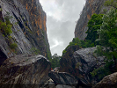
Green Point is a nice lookout over Glenbrook Creek. The lookout is at the end of Greens Road trail, which runs off Greens Road in Warrimo.
OpenStreetMap shows a route off from the lookout heading down towards Glenbrook Creek through passes in two cliff lines, but stopping at about the 150m contour. It's labelled "Green Point Scramble". I've searched in Google and on bushwalk.com and turned up absolutely zero!
I went out and had a look today. I found the pass through the first cliff line. Without a rope and with a slightly nervous buddy I didn't go any further, but I'm fascinated. I'd like to make a loop walk off Green Point down to Glenbrook Creek, up Kings Link to Bunyan Lookout, Lost World, down the ridge to Shark's Head Cave and Western Creek then up Martins Lookout or Fairy Dell Track. Happy to take a rope and abseil if needed so long as I know I can get to the bottom.
Does anyone have any knowledge of Green Point Scramble?
Green Point Scramble
Forum rules
NSW & ACT specific bushwalking discussion. Please avoid publishing details of access to sensitive areas with no tracks.
NSW & ACT specific bushwalking discussion. Please avoid publishing details of access to sensitive areas with no tracks.
3 posts
• Page 1 of 1
Green Point Scramble
![]() by TonyM » Sun 16 Apr, 2023 9:17 pm
by TonyM » Sun 16 Apr, 2023 9:17 pm
- TonyM
- Nothofagus cunninghamii

- Posts: 2
- Joined: Sun 16 Apr, 2023 8:58 pm
- Region: New South Wales
- Gender: Male
Re: Green Point Scramble
![]() by TonyM » Mon 17 Apr, 2023 11:58 am
by TonyM » Mon 17 Apr, 2023 11:58 am
... or a loop with Bunyan Lookout, The Bullants Track, Florabella Pass ...
- TonyM
- Nothofagus cunninghamii
- Posts: 2
- Joined: Sun 16 Apr, 2023 8:58 pm
- Region: New South Wales
- Gender: Male
Re: Green Point Scramble
![]() by YoungCodger » Wed 19 Apr, 2023 4:52 pm
by YoungCodger » Wed 19 Apr, 2023 4:52 pm
Hi Tony,
I put that pass on OSM. I was out scrambling, trying to find a pass and came across a cairned route. I asked my dad's next door neighbour about it and he said it's been in use for at least a couple of decades. I use it all the time and know at least a few others do too. There are a few cairns. If your navigation is on point, it's fine to do without a rope. Happy to show you in person if you like. If you get off route it gets sketchy.
I didn't plot the section below the pass on OSM, as there's no clear track to the creek unfortunately. It would probably be better for the bush if people stuck to one path between the cliff line and the water.
And yes it's fun to link up all the miniature peaks out there. My go-to run is Pippa's Pass - Bullant Ridge - Shark's Head Cave - Martin's LO - Kings Link - Green Point - Florabella - Pippa's Pass. That gets you 1000m of vert in about 16km.
-
YoungCodger - Nothofagus gunnii

- Posts: 39
- Joined: Mon 10 Feb, 2020 7:12 pm
- Region: New South Wales
- Gender: Male
3 posts
• Page 1 of 1
Return to New South Wales & ACT
Who is online
Users browsing this forum: No registered users and 41 guests