Forum rules
Victoria specific bushwalking discussion. Please avoid publishing details of access to sensitive areas with no tracks.Re: Bogong High Plains region tracks
Fri 12 Mar, 2021 8:12 am
Lophophaps wrote:The scales may not be the same for the spurs but the profiles are correct. I'd be happy if my pack was 30 kg lighter, like a helium balloon.
From Bogong Jack turn Fainter North then go on the track for a short way, then off track to the summit. From there off track or with a bit of track to Fainter South. Pick up the track to Little Plain, then south-west to the ridge, which is followed to Jaithmathang. It's lovely walking with mainly open and flat terrain, a few scrubby patches, rocky outcrops and a rocky summit. From Jaithmathang, down the track to the saddle south of the summit and west of Tawonga Huts, passing reliable water, good if you want to camp in the saddle. From the saddle it's possible to go south-east on the ridge to meet the Tawonga Hut pole line about half way between the Fainter FT and pole 333.
The picture below is from Fainter North, looking south. The track is just visible on the shoulder on the left in the middle distance.
Nice photo! I can see the track where you point it out. The walk/views look like a great reward for the long walk up.
I didn't know there was a Pole line from Tawonga Hut. I just thought it was from Mt Hotham to Mt Bogong.
Re: Bogong High Plains region tracks
Fri 12 Mar, 2021 8:14 am
paidal_chalne_vala wrote:Closer examination of the new SV Map of the Bogong Alpine area shows that they claim there is a hut on the summit of Mt.Bogong , there are a number of huts along the Bogong Creek tramway and water race and many other fanciful , false and incorrect things are denoted on this map . It is a hard copy map which is rapidly becoming a joke the more I look at it.
I think there was a summit hut, and what remains of it is now the cairn at the summit.
One more profile for comparison. As I said, Long Spur is aptly named.
Re: Bogong High Plains region tracks
Fri 12 Mar, 2021 9:25 am
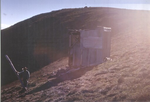
In 1976 (I think that was the year) Summit, Bivouac and Aertex Huts were intentionally burnt, a good idea as all were marginal. There was a plan to have a hut under the summit cairn. Right. Highest mountain in Victoria, exposed, no shelter, no toilet areas, no toilet, cramped, totally dark, door likely to be frozen in winter. Sanity prevailed.
A 1973 picture of Summit Hut is below. Note the track, lots of grass.
The map below shows the pole line from pole 333 to Tawonga Huts. The red arrows show the approximate routes that I describe. The picture is from pole 333 looking along the Tawonga Huts pole line. The bumps at the back are either Jaithmathang or the Fainters. Clockwise from the Tawonga Huts poles are Cope, pole 267 and Westons, the one at an angle.
Re: Bogong High Plains region tracks
Mon 22 Mar, 2021 5:55 pm
Out_Walking wrote:
Coming up from Bogong Village to the road I went left and then up that incline track in the right of the pic. It led me to the track and although I expected a gate some place, there wasn't any. That was March 2019 though, but I'd be surprised if it's any different now.
I was up at Falls Creek over the weekend so I thought I'd stop and check out the access to Springs Saddle Track above Bogong Village. Out Walking has identified the easiest route. Head up the rough track on the Falls side of the Bogong Village entrance Road - pass by a water treatment plant (with a convenient safety shower) - climb steeply up a rough track at the far end of the treatment plant and pass underneath some power lines - meet the perimeter fence of the AGL worksite - either climb steeply beside the fence or take an old 4wd track up to meet Springs Saddle Track at the top gate of the AGL compound. It's shorter than the old route off the High Plains Road straight up Springs Saddle Track.
- Looking from the Bogong Village entrance road.
- Head past the water treatment plant.
- Climb steeply under some powerlines.
- Arrive at the AGL compound fence.
- Either climb steeply beside fence...
- ... or climb a bit easier up an old 4wd track...
- ... to meet Spring Saddle Track...
- ... just up the hill from the gate (that always seems to be open at this end?)
It's all pretty obvious on the ground however I've got a GPX file if anyone thinks they need one.
Cheers
Re: Bogong High Plains region tracks
Mon 22 Mar, 2021 9:21 pm
Re: Bogong High Plains region tracks
Tue 23 Mar, 2021 10:17 am
Re: Bogong High Plains region tracks
Tue 23 Mar, 2021 10:17 am
Re: Bogong High Plains region tracks
Tue 23 Mar, 2021 11:02 am
Baeng72 wrote:What kind of night time temps can you expect up on the BHP in April? I'm guessing around 0. If I can find a window in the weather where it's fine (or not a blizzard with howling gale at least) that fits in with time I'm free I'll sneak up there and see what (mis)adventure I can get up to.
That's my plan
Make sure that you heed Moondog55's oft repeated advice that temperatures out on BHP can be significantly lower than temps forecast for Falls Creek. I can confirm, from my most recent (precovid), BHP trip that this is wise advice.
Re: Bogong High Plains region tracks
Tue 23 Mar, 2021 11:06 am
Especially if it's a clear weather, then without cloud, the temp will drop overnight more.
http://www.bom.gov.au/climate/averages/ ... 3084.shtml
Re: Bogong High Plains region tracks
Tue 23 Mar, 2021 1:16 pm
Re: Bogong High Plains region tracks
Sun 28 Mar, 2021 1:08 pm
Re: Bogong High Plains region tracks
Sun 28 Mar, 2021 8:07 pm
I've read that you park beside a trout farm for Tom Kneen and there's a 2WD accessible track up to the gate on Stony Tops to access North Razorback.
- Trout Farm
- feather2.JPG (104.33 KiB) Viewed 21364 times
- Stony Tops
Re: Bogong High Plains region tracks
Sun 28 Mar, 2021 9:33 pm
Re: Bogong High Plains region tracks
Sun 28 Mar, 2021 10:20 pm
But I've read (I read too much, never do, call me Gunna. I'm gunna do something one day....), that the carpark is now like you say, down the road at Tronoh reserve (Tronoh Monster was a mobile dredge that basically smashed the river flats for aluvial gold and left billabongs/holes - apologies if you know this).
.Council has been working with the community, the Tronoh Reserve Committee of Management and Parks Victoria to facilitate suitable, safe parking for visitors to the popular Bungalow Spur Walking Track up Mount Feathertop.
This week new signage will be visible to those visiting the walking track:
- A series of permanent signs will designate the area immediately opposite the existing trailhead on Feathertop Track as a drop off zone only, designed for motorists to drop off and collect walkers and their equipment.
- A temporary Variable Message Sign will be installed to direct motorists to a new carparking area in the Tronoh Reserve and limit vehicular traffic on Feathertop Track.
https://www.parks.vic.gov.au/places-to- ... -spur-walk
- feathertop4.JPG (180.18 KiB) Viewed 21350 times
Re: Bogong High Plains region tracks
Mon 29 Mar, 2021 9:30 am
- Bungalow Spur car park January 2021
- Bungalow parking.JPG (175.5 KiB) Viewed 21294 times
Re: Bogong High Plains region tracks
Mon 29 Mar, 2021 10:19 am
Re: Bogong High Plains region tracks
Mon 29 Mar, 2021 11:39 am
Not sure about the situation re Plods, but there's a public toilet with car park just as you're leaving town at the Hotham end. I'd think that'd be a place you could park and have a nap.
I would've said the trailhead for the Bungalow Spur, but that's a drop-off zone now, so someone will get miffed if cars are parked all night. It might be OK in the new carpark.
The Bon-Accord trailhead is on a gravel road, but you might be able to park there at dusk and snooze away.
Re: Bogong High Plains region tracks
Mon 29 Mar, 2021 12:19 pm
peregrinator wrote:A tangential question, if I may? Are there places in or around Harrietville that are suitable for sleeping in a car on the night before setting off on any of the three spurs mentioned above?
Apart from the spots already named, you could simply hide anywhere out of sight of houses, so that the visual presence of a unknown car doesn't concern residents
Re: Bogong High Plains region tracks
Mon 29 Mar, 2021 3:31 pm
Re: Bogong High Plains region tracks
Wed 31 Mar, 2021 8:06 am
How cold does it get up above 1500 M. in March and April?. I have had frost on both instances this month. Be prepared for COLD nights.
The Night before any Mt. FT trip used to involve a camp site by the Ovens river near the old bridge that joins Snowy Creek road. It is just before Freeburgh .
Going up to the Fainters is a slog if you start at the Bogong Village end. I can recommend starting at Big Hill and taking the West Kiewa Logging road and the Saddle Spring fire track( name ? ) to the Spring Saddle and going from there.
Re: Bogong High Plains region tracks
Wed 19 May, 2021 2:16 pm
Re: Bogong High Plains region tracks
Thu 20 May, 2021 11:04 pm
Lophophaps wrote:It's not worth starting a thread on this. What are the rocks on the summit of Feathertop? Shale? Granite?

Re: Bogong High Plains region tracks
Thu 27 May, 2021 10:23 am
https://gsv.vic.gov.au/sd_weave/anonymous.html
but it's powerful magic. David Higgins of the Geological Survey of Victoria was of great assistance in explaining the site.
Feathertop has Pinnak Sandstone (Oap), which does not stand of Old Age Pensioner.
Re: Bogong High Plains region tracks
Thu 27 May, 2021 1:54 pm
Lophophaps wrote:Icefest, thanks. It took a while to work out how to use
https://gsv.vic.gov.au/sd_weave/anonymous.html
but it's powerful magic.
I've downloaded all the data and imported it into QGIS (a mapping data program) and exported from that, but that's a whole level more complex than that mapping server you've linked.
The biggest issues ive found is that the original documents describing the geological layers (from the 60's) are still locked behind a 60$ paywall, so I can't read them....
Re: Bogong High Plains region tracks
Mon 07 Jun, 2021 12:25 pm
From Loch car park go uphill on the road for a few minutes, then turn left on the management track to the summit of Hotham. From there go south-west on the ridge on a foot track, then steeply down to a gentler descending traverse to Diamantina Hut.
Re: Bogong High Plains region tracks
Mon 07 Jun, 2021 4:29 pm
- Loch carpark to Diamantina Hut
Re: Bogong High Plains region tracks
Tue 08 Jun, 2021 7:15 am
Re: Bogong High Plains region tracks
Tue 08 Jun, 2021 7:43 am
Take it with a healthy pinch of salt.
I just looked at my SV Bogong Alpine Area map and it only shows a track from 'The Cross' up to Hotham summit and then over to Diamantina Hut.
But the SV map shows a Hut on the summit of Mt Bogong, which is where I got the idea that there was a hut there at one stage in the past, but it appears the hut wasn't at the summit, so again, take it with a pinch of salt.
Re: Bogong High Plains region tracks
Tue 08 Jun, 2021 8:36 am
Lophophaps wrote:Is the following correct?
From Loch car park go uphill on the road for a few minutes, then turn left on the management track to the summit of Hotham. From there go south-west on the ridge on a foot track, then steeply down to a gentler descending traverse to Diamantina Hut.
Ski runs I would think.
Baeng72 wrote:Now that you mention it, the hut names are wrong on the GetLost map.
Take it with a healthy pinch of salt.
I just looked at my SV Bogong Alpine Area map and it only shows a track from 'The Cross' up to Hotham summit and then over to Diamantina Hut.
But the SV map shows a Hut on the summit of Mt Bogong, which is where I got the idea that there was a hut there at one stage in the past, but it appears the hut wasn't at the summit, so again, take it with a pinch of salt.
There was once a summit hut on Bogong but it was burnt down along with other huts (arson) Oct 1978.
Re: Bogong High Plains region tracks
Tue 08 Jun, 2021 8:55 am
There was a hut on Mt Bogong called the 'Summit Hut'.
What I thought, and SV maps indicates is the Summit Hut was located at the summit, where there is now a large stone cairn.
I think I read somewhere that the cairn was composed of rocks from the same hut.
But, I've seen a photo, which I believe Lophophaps or some other denizen of these parts posted indicating it was on the summit ridge or just below, but not near the highest point and it was made of corrugated iron, and not rocks like at the summit cairn.
I can't find the link, but this might be the same from a different angle:
© Bushwalk Australia and contributors 2007-2013.