Recommend me a 3-4 day challenging hike! *Trip report*

Victoria specific bushwalking discussion.
Forum rules
Victoria specific bushwalking discussion. Please avoid publishing details of access to sensitive areas with no tracks.

Recommend me a 3-4 day challenging hike! *Trip report*

Postby Tofu_Imprint » Sat 07 May, 2011 4:53 pm

Hey all,

First post, found this site looking for information on Lake Tali Karng and Mt Bogong. I got info for both :)
Next week, a mate of mine and I want to go for a decent hike for 3-4 days. I'm wondering what people on here would recommend, a challenge is always good!

We are located in the NE VIc, arond 1.5 hours from melbourne. I'm willing to drive to get to a good destination starting point! But within victoria would be better.
We both like more remote hikes, so please no commercial trails riddled with people! We are more interested in a challenging walk, perhaps intermediate-hard in difficulty.

Thanks in advance.
:)
Last edited by Tofu_Imprint on Sun 15 May, 2011 7:11 pm, edited 1 time in total.
User avatar
Tofu_Imprint
Atherosperma moschatum
 
Posts: 90
Joined: Sat 07 May, 2011 4:47 pm
Location: NE VIC
Region: Victoria
Gender: Male

Re: Recommend me a 3-4 day challenging hike for next week!

Postby MartyGwynne » Mon 09 May, 2011 3:28 am

Howdy.
I am not sure what sort of vehicle you have to get to get to the start point but I could suggest the Viking circuit for you.
It takes in (starting from South Vic side) Mt Howit, Cross Cut Saw, Mt Buggery, Mt Speculation, Mt Despair, The Razor, The Viking, Drop down into Wonangatta Valley, up and back to the Mt Howit carpark (Macalister Springs car park).
You could start on your side by walking up half way along the Cross Cut Saw or by 4WD at Mt Speculation.
It has some hard slogs in it both up and down a few rock climbs (no need for ropes but you may need to hoist your packs up 3-4 metres).
Water can be a bit hard to find at times but it seems to be wet this year so should be OK.
I have no knowledge of commercial groups using it but it does get some use early in the year (from Nov on).
I have done it several times and it must be one of the best circuits around in Vic.
Normally starting at Mt Howit and camp at either Mt Spec or Katherine Saddle (just before Mt Despair), then onto the Viking Saddle Just below the Viking (or camp on top very good views), then on to Wonangatta and camp or walk up to Mt Howit car park.
It depends on how well you are travelling as to where you camp. You have two or three different ways up from Wonangatta Valley a) up the 4wd track then across to Howit car park, b) Up the dry river track to the road then several kms along the road to Howit car park, c) up the spur opposite from where you came down off the Viking (make sure you get the right spur down the Viking) which gets you back to Macallister Springs (about 4-5 kms shorter than Howit car park).
But given there is snow forecast down to 1100M in the next few days you will have to be prepared and experienced in doing a bit of snow walking and navigation in low cloud which upon reflecting this it may be best to leave this trip for good weather only.
How much walking experience do you and your mate have?
I have seen a few guys on that track/route looking very very exhausted and getting into camp very late (even been geographically embarrased on top of the Viking myself before).
There may be a Viking circuit trip report etc on this forum somewhere.

Or you could get to Harrietville zip up to Mt Feathertop across to Mt Hotham then along the AAWT to near te Tawonga huts then down to the river and up the dimentina Spur (ha Ha) back up Mt Feathertop again and home. Hehe he that spur is a good one last time it took me 6 or so hrs slog up and up and up....
Need to look at map again to remember the exact route but you do follow a made track and even snow poles. I think it is a John Chapman/ Siseman type of walk memory fails me at this time of night (at work).
Cheers.
Hope it helps you
Marty.
User avatar
MartyGwynne
Athrotaxis cupressoides
 
Posts: 355
Joined: Sun 30 Jan, 2011 4:31 am
Region: Victoria
Gender: Male

Recommend me a 3-4 day challenging hike for next week!

Postby andrewbish » Mon 09 May, 2011 6:26 am

Lerdederg Gorge is an interesting and challenging 3 day walk.
Twitter: @andrewbishxplor Blog: Trails & tracks
User avatar
andrewbish
Phyllocladus aspleniifolius
 
Posts: 802
Joined: Mon 03 Jan, 2011 7:08 pm
Location: Melbourne
Region: Victoria
Gender: Male

Re: Recommend me a 3-4 day challenging hike for next week!

Postby Tofu_Imprint » Mon 09 May, 2011 9:36 am

Thankyou Andrew and Marty.
Marty that is great information, and sounds like a great walk.
Andrew I will have a look for more information on Lerdegerg.

RE: Experience. General walking we like too think we are fit :D Snow walking our experience is limited. My mate is from Canada so obviously he's done quite a lot, I haven't done too much walking but have done alot of cross country skiing.
We are well geared up, but perhaps your right, it might be better to err on the safer side and save that for nicer weather (saw the forecast).
User avatar
Tofu_Imprint
Atherosperma moschatum
 
Posts: 90
Joined: Sat 07 May, 2011 4:47 pm
Location: NE VIC
Region: Victoria
Gender: Male

Re: Recommend me a 3-4 day challenging hike for next week!

Postby north-north-west » Tue 10 May, 2011 8:04 pm

Drive into The Playground, over Cobberas 1, Middle, Cleft, Cobberas 2, down to Cowombat Flat, take the track over Cowombat Ridge to the Tin Mines, with side trips to Tin Mine Falls and The Pilot. Back along the Cowombat Flat track and cross the ridge at Bulley Creek. Mostly off-track but it's not all that scrubby is you pick the right lines.
"Mit der Dummheit kämpfen Götter selbst vergebens."
User avatar
north-north-west
Lagarostrobos franklinii
 
Posts: 15151
Joined: Thu 14 May, 2009 7:36 pm
Location: The Asylum
ASSOCIATED ORGANISATIONS: Social Misfits Anonymous
Region: Tasmania

Re: Recommend me a 3-4 day challenging hike for next week!

Postby iGBH » Fri 13 May, 2011 7:00 pm

andrewbish wrote:Lerdederg Gorge is an interesting and challenging 3 day walk.


I'm surprised by the enthusiasm to Lerdederg. Having done most of my walking in the alps, i find this place very uninspriring. Couldn't think of much worse than 3 days here, 2 was more than enough.
iGBH
Athrotaxis cupressoides
 
Posts: 135
Joined: Sat 29 Jan, 2011 8:19 pm
Region: Victoria
Gender: Male

Re: Recommend me a 3-4 day challenging hike for next week!

Postby north-north-west » Fri 13 May, 2011 7:24 pm

It's a good place for fungi and rednecks.
"Mit der Dummheit kämpfen Götter selbst vergebens."
User avatar
north-north-west
Lagarostrobos franklinii
 
Posts: 15151
Joined: Thu 14 May, 2009 7:36 pm
Location: The Asylum
ASSOCIATED ORGANISATIONS: Social Misfits Anonymous
Region: Tasmania

Recommend me a 3-4 day challenging hike for next week!

Postby andrewbish » Fri 13 May, 2011 7:29 pm

Fair enough iGBH. Perhaps you could suggest a good 3-4 day alpine walk for Tofu :)
Twitter: @andrewbishxplor Blog: Trails & tracks
User avatar
andrewbish
Phyllocladus aspleniifolius
 
Posts: 802
Joined: Mon 03 Jan, 2011 7:08 pm
Location: Melbourne
Region: Victoria
Gender: Male

Re: Recommend me a 3-4 day challenging hike for next week!

Postby iGBH » Sat 14 May, 2011 6:07 pm

andrewbish wrote:Fair enough iGBH. Perhaps you could suggest a good 3-4 day alpine walk for Tofu :)


Can do. :)

Although my favourites have already been mentioned in some form. Either a Bogong circuit similar to the trip report on here by NNW, or alternatively Bindaree-Helicopter Spur-Howitt-Viking-Speculation-King Spur.
iGBH
Athrotaxis cupressoides
 
Posts: 135
Joined: Sat 29 Jan, 2011 8:19 pm
Region: Victoria
Gender: Male

Re: Recommend me a 3-4 day challenging hike for next week!

Postby Tofu_Imprint » Sun 15 May, 2011 7:09 pm

So we had an epic challenging time :D

We were going to go to King hut -> Mt speculation -> Lake Cobbler -> King Hut. But the road access to King hut was rubbish, factoring in road closures it would have being a 50 km loop. Not feasible at all in the snow we had!

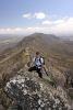
We decided to go to 8 mile flat, walk up the 8 mile spur, walk up the rocky spur down to refrigerated gap and onto the bluff hut on day 1. Day two would be checking out the bluff (1700m or so), then walking down to ritchies hut. day 3 back to 8 mile flat. We had too change things around mid-trip.
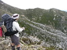
TRIP:
We set out early and at around 800m up on 8 mile spur we found snow. The snow got deeper and deeper until it was around 20cm cover everywhere (and more higher up). Visibility was rubbish, the track was steep and we had 23kg packs. It was drizzling the whole time/snowing higher up. Snow at this time of the year in such a level of cover (and at such a low altitude) is pretty rare I believe. There was no track markers and no track to follow after a certain point. The call was made to continue and we used a map and compass to navigate too refrigerated gap. Around 1km from refrigerated gap we went south-south-east to find a 4wd track lower down, as we didnt want to overshoot the ridge turn off with such crappy visibility. We found the 4wd track and camped just up from refrigerated gap in a decent clearing. there was a good cover of snow and it was freezing.

We slept well/warm even though it was freezing outside. some snow fell overnight but it turned to rain by morning. we had too make a choice after breakfast. walk 16km back on a 4wd road, or walk another 6km too the hut, camp and walk back 21km the next day. we had some wet gear and didn't want to take any chances, so we made the call to walk back. this is a very short version of the trip. it was very strenous, invoved mainly climbing in fairly deep and fresh snow, with no visibility and no track markers. it was a test of endurance, good gear and navigation. i'm glad we did it and i'm glad that the lost man was found also! we found out about this when we let the mansfield cops know we were back!

cheers.

PS we did not carry a PLB or GPS.
User avatar
Tofu_Imprint
Atherosperma moschatum
 
Posts: 90
Joined: Sat 07 May, 2011 4:47 pm
Location: NE VIC
Region: Victoria
Gender: Male

Re: Recommend me a 3-4 day challenging hike! *Trip report*

Postby marangaroo86 » Sun 15 May, 2011 8:01 pm

I have been waiting to hear what trip you where going to do.
The best made plans often go astray especially when the weather dictates a change.
Sounds like a challenging hike was had.
I love that area :D , especally Lake cobbler, Mt cobbler
I find early snow aways exciting, even if it make a walk into an epic.
Thanks for the quick report Wish I was out there! :mrgreen:
marangaroo86
Atherosperma moschatum
 
Posts: 79
Joined: Mon 11 Apr, 2011 1:23 pm
Region: New South Wales
Gender: Male

Recommend me a 3-4 day challenging hike! *Trip report*

Postby andrewbish » Mon 16 May, 2011 6:43 am

Sounds like hard yakka!
Twitter: @andrewbishxplor Blog: Trails & tracks
User avatar
andrewbish
Phyllocladus aspleniifolius
 
Posts: 802
Joined: Mon 03 Jan, 2011 7:08 pm
Location: Melbourne
Region: Victoria
Gender: Male

Re: Recommend me a 3-4 day challenging hike! *Trip report*

Postby Earwig » Wed 18 May, 2011 2:07 pm

I hiked The Bluff back in May 2010.

http://www.youtube.com/watch?v=Nq71iSeR8E4

My original plan was to hike over two days from Eight Mile Flat, up Eight Mile Spur and across to camp at Bluff Hut (13km), returning down Sixteen Mile and along the Howqua the next day (16km) but we cut it short and walked from Bluff Carparkto Bluff Hut and back along Bluff Link Rd the next day. Great walk and I want to do it again - and do the whole circuit, preferably when the roads are closed as there were deer hunters hooning around when we were there.
Live life moving around so when you're dead people can tell the difference.
MY HIKING BLOG http://ian-folly.blogspot.com/
User avatar
Earwig
Athrotaxis cupressoides
 
Posts: 289
Joined: Wed 11 Nov, 2009 3:25 pm
Location: NE Victoria
Region: Victoria
Gender: Male

Re: Recommend me a 3-4 day challenging hike! *Trip report*

Postby north-north-west » Wed 18 May, 2011 6:47 pm

Those roads are only closed after extreme events (like the floods), except the Bluff 4WD Track.
"Mit der Dummheit kämpfen Götter selbst vergebens."
User avatar
north-north-west
Lagarostrobos franklinii
 
Posts: 15151
Joined: Thu 14 May, 2009 7:36 pm
Location: The Asylum
ASSOCIATED ORGANISATIONS: Social Misfits Anonymous
Region: Tasmania

Re: Recommend me a 3-4 day challenging hike! *Trip report*

Postby MartyGwynne » Thu 19 May, 2011 3:12 am

Well done guys.
(subliminal message get a PLB)
I spent the week cowering in my lounge room feeding the fires trying to keep warm.
(subliminal message get a PLB)
I had walked the Great Ocean Walk the week before, not too bad weather wise and a lovely walk will have to go back and re-do the last bit as high tides kept me away from the best beach/rock part of the walk.
(subliminal message get a PLB)
I must get to walk in that area, as it looks very interesting.
(subliminal message get a PLB)
Wise move on going back it sounded like a tough slog through the snow.
(no subliminal message required, you get the idea)

Marty.
User avatar
MartyGwynne
Athrotaxis cupressoides
 
Posts: 355
Joined: Sun 30 Jan, 2011 4:31 am
Region: Victoria
Gender: Male

Re: Recommend me a 3-4 day challenging hike! *Trip report*

Postby Tofu_Imprint » Mon 23 May, 2011 5:29 pm

MartyGwynne wrote:Well done guys.
(subliminal message get a PLB)
I spent the week cowering in my lounge room feeding the fires trying to keep warm.
(subliminal message get a PLB)
I had walked the Great Ocean Walk the week before, not too bad weather wise and a lovely walk will have to go back and re-do the last bit as high tides kept me away from the best beach/rock part of the walk.
(subliminal message get a PLB)
I must get to walk in that area, as it looks very interesting.
(subliminal message get a PLB)
Wise move on going back it sounded like a tough slog through the snow.
(no subliminal message required, you get the idea)

Marty.


I dont know why but I somehow feel the urge too buy a PLB all of a sudden :)
I am kind of waiting for the new kti mini-sat unit too come out (december apparently).
When this contract ends i'm either doing the GSSW solo as an easy hike, or shooting off to NZ too meet up with a mate for some hiking.
Canada is also a possibility this year/next.

cheers all.
User avatar
Tofu_Imprint
Atherosperma moschatum
 
Posts: 90
Joined: Sat 07 May, 2011 4:47 pm
Location: NE VIC
Region: Victoria
Gender: Male

Re: Recommend me a 3-4 day challenging hike! *Trip report*

Postby MartyGwynne » Tue 24 May, 2011 11:05 am

I waited for while for the KTI one as it sounds great. It was going to be out in November (a few years ago).
I would read up on some of the threads on this site regarding technical type of things/gadgets/gear as there is a good one running for about 3 or so years which has some very interesting techo points to consider.
I have a GME PLB with sat location, have used the spot type of ones which are good for those who want to track their walk (but has the I am OK but will be late function).
So instead of waiting for the one which does everything to come out I just bought one and will use it for a few years then maybe one will come out which will even cook my dinner......... :-)
User avatar
MartyGwynne
Athrotaxis cupressoides
 
Posts: 355
Joined: Sun 30 Jan, 2011 4:31 am
Region: Victoria
Gender: Male

Re: Recommend me a 3-4 day challenging hike for next week!

Postby dplanet » Fri 10 Feb, 2012 5:58 pm

iGBH wrote:
andrewbish wrote:Lerdederg Gorge is an interesting and challenging 3 day walk.


I'm surprised by the enthusiasm to Lerdederg. Having done most of my walking in the alps, i find this place very uninspriring. Couldn't think of much worse than 3 days here, 2 was more than enough.


Have also experienced the alps for years; but, have to disagree with iGBH as there're many options to walk in Lerdederg River Gorge.

I had a wonderful & challenging three and a half day walk in there in September last year. It was the creek - the river- The Lerdederg River Gorge circuit walk with the start and finish near south of Mt Blackwood.
User avatar
dplanet
Phyllocladus aspleniifolius
 
Posts: 580
Joined: Thu 04 Oct, 2007 8:21 pm
Location: Ormond-Caulfield, Melbourne
Region: Victoria
Gender: Female


Return to Victoria

Who is online

Users browsing this forum: No registered users and 10 guests

cron